Showing 291 items matching "break up"
-
 Melton City Libraries
Photograph, Gnotuk Park, 1970
... farm properties established in the historic break-up... properties established in the historic break-up of the large pastoral ...Built in 1897, "it is one of the best-known of the Melton farm properties established in the historic break-up of the large pastoral estates at the turn of the twentieth century". Melton Heritage Study Stage 2 Volume 3Farm house located at 2389-2485, Diggers Rest-Coimadai Road, Diggers Rest. local architecture, local identities -
 Kiewa Valley Historical Society
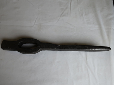
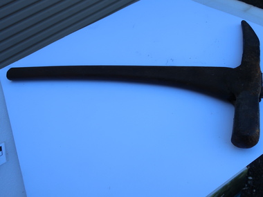
Miners' Pick Axe Head
... Miners used pickaxes to break up rock and ore, making... used pickaxes to break up rock and ore, making it easier ...Miners used pickaxes to break up rock and ore, making it easier to extract valuable minerals. The pointed end of the pickaxe was used to chip away at rock. The flat end was used to strike the rock for breaking it apart.Used in the Kiewa Valley by miners searching for gold.Cast steel 14 inches long with a sharp pointed end and a small flat end. There is a space for the handle which is missing and may have been made from wood.mining, miners' pick axe -
 Eltham District Historical Society Inc
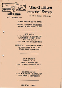
Newsletter, Newsletter, No. 57 November 1987
... Island Trip • Christmas Break-up • Twentieth Anniversary... Island Trip • Christmas Break-up • Twentieth Anniversary ...Contents: • Next meeting, guest speaker; David Cameron, Botanist: The significance of the Eltham area for nature conservation • Eltham Community Festival • November Meeting • Churchill Island Trip • Christmas Break-up • Twentieth Anniversary Functions • Other Brief Items The Shire of Eltham Historical Society was formed in October 1967. The first newsletter of the Society was issued May 1978 and has been published continuously ever since on a bi-monthly basis. With the cessation of the Shire of Eltham in late 1994, the Society's name was revised to Eltham District Historical Society and this name first appeared with issue No. 103, July 1995. The collection of the Society's newsletters provides a valuable resource on the history of the Society's activities, office bearers and committee members, guest speakers and subjects of historical interest pertinent to the former Shire of Eltham and the Eltham District.A4 photocopied newsletter distributed to membersnewsletter, eltham district historical society, shire of eltham historical society -
 Bendigo Military Museum
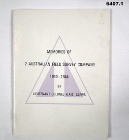
Booklet - Memories of 2 Australian Field Survey Company 1940-1944 by LtCol HPG Clews, HPG Clews, 23 Sep 1966
... "The buildup and operation of the Company", "The break-up... "The buildup and operation of the Company", "The break-up ...1. This story of 2 Australian Survey Company is not intended to be an official history or even a complete unofficial history, but it is a very warm human document that will be read with interest by all members of the Royal Australian Survey Corps. The history is written by Lieutenant Colonel H.P.G. Clews and the foreward was written by Colonel D. Macdonald Director of Military Survey 23 Sep 1966. Clews is renowned for his work surveying for the construction of the Snowy Mountains Hydro Scheme. A scan of the complete booklet is available on the RASvy website. 3. Photograph of Survey Corps officers in the early days for WWII. Left to right, TA Vance (Director of Survey Corps), TP Keig, OGF Ward and HPG Clews..1 Cream coloured A5 booklet with Australian Survey Corps colour patch, 48 pages black and white photos and diagrams, folded pages and stapled. .2 Synopsis, (Index) containing "The buildup and operation of the Company", "The break-up of the Company" and Appendices. 2 Australian Field Survey Company .3 A group of Australian Survey Corps Officers in the early days of WWII. Left to Right TA Vance (Director), TP Keig, OGF Ward and HPG Clewsroyal australian survey corps, rasvy, fortuna, army survey regiment, army svy regt, asr -
 Orbost & District Historical Society
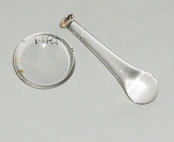
mortar and pestle
... the pestle. It would have been used to break up tablets. (identified... the pestle. It would have been used to break up tablets. (identified ...Veterinary equipment. Although glass mortars and pestles are fragile, they are stain-resistant The substance to be ground is placed in the mortar and ground, crushed or mixed using the pestle. It would have been used to break up tablets. (identified by vet. Peter Honey) These items were found in an old walk-through dairy at Wombat Track near Orbost. These items are representative of items used in Orbost on dairy farms in the first half of 20th century.A mortar and pestle. The mortar (2397.1) is a shallow bowl. The pestle (2397.2) is a blunt club-shaped object, the end of which is used for crushing and grinding. Both are made of glass.veterinary-equipment mortar-pestle dairy farming -
 Bendigo Historical Society Inc.
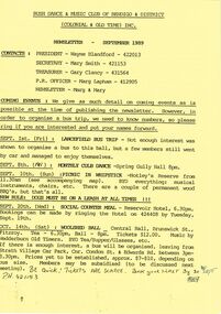
Document - PETER ELLIS COLLECTION: BUSH DANCE AND MUSIC CLUB BENDIGO, September
... Break-up and next meeting. On the back is the monthly dance.... The December issue has the contacts, Christmas Break-up and next ...Three Bush Dance & Music Club of Bendigo & District Newsletters, Sept 1989 (yellow), October 1989 (green) and December 1989 (yellow). Newsletters contain contacts, Coming Events, dance programs and September 1989 edition has a map of how to get to the Notley's Picnic area. Also reports and in the October edition a sketch of how to get to a picnic area in the Wellsford Forest. The December issue has the contacts, Christmas Break-up and next meeting. On the back is the monthly dance dates for 1990.clubs, music, bush dance & music club of bendigo, peter ellis collection, bush dance & music club of bendigo & district, wayne blandford, mary smith, gary clancy, marg lapham, notley's reserve, reservoir hotel, wedderburn old timers, harry mcqueen & friends, lorraine ogilvie, mike jackson, val wilson, barry simpson, peter ellis, victorian folk music club, shirley andrews, john meredith -
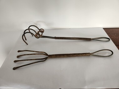
 Kiewa Valley Historical Society
Miners Pick - short
... Formerly KV 071. It was used to break up rock and ore... KV 071. It was used to break up rock and ore, making ...Formerly KV 071. It was used to break up rock and ore, making it easier to extract valuable minerals. The pointed end of the pick axe was used to chip away rock, while the flat end was used to strike the rock for breaking it apart. This one has a short handle. Miners picks were commonly used in the the 19th and early 20th centuries for extracting gold from underground mine tunnels.Used in the Kiewa Valley where prospecting for gold occurred.Formerly KV 071. Cast iron symmetrical pick tool on cast iron with a wooden handle. It has a pointed end and a flat end. It is 12 inches long.gold mining, miners' pick axe, hand tool -
 Sunbury Family History and Heritage Society Inc.
Photograph, December 1988
... at the end of the school year on 'break-up' day. ... of the school year on 'break-up' day. This is a visual record ...The five women photographed were staff members at Bulla Primary School in 1988. They are from L-R: Sue Bradley, grades 2/3 teacher, Ivy Grant, music teacher, Carol Hitchens, grades 4-6 teacher and principal, Kim Barber, integration aide and Jenny Wilson, grades Prep and 1 teacher. The photograph was taken at the end of the school year on 'break-up' day. This is a visual record of the school staff who were employed at Bulla primary School in December 1988.A coloured non-digital photograph of five ladies standing in a covered area, on a landing outside a weatherboard building.bulla primary school, sue bradley, ivy grant, carol hitchens, jenny wilson, kim barber -
 Kiewa Valley Historical Society
Painting, Cattlemen of the Bogong High Plains, c1995
... was to break up the parts in the painting and use these as large... (where the liquor store is now). His idea was to break up ...Leo Wimmer who lived locally was commissioned to do the painting for the Mt Beauty, S. K. Pearce Pty. Ltd., Supermarket as a display was wanted to fit against the blank walls opposite the cash registers (where the liquor store is now). His idea was to break up the parts in the painting and use these as large replicas painted on wood for the display. An official opening was held and Leo used the money earned to visit his homeland, Austria. Leo trained as a restorer of church art in Austria.This painting was commissioned for a Cattlemen's display behind the cash registers at the Mt Beauty S. K. Pearce Supermarket. Each part of the foreground was painted separately onto stand alone boards -the cattle, the hut, the grass and the Mt Beauty township. Leo Wimmer lived locally and was a professional frame conservator. Leo Wimmer specialised in gilding and worked at the National Gallery of Victoria and later the National Gallery of Australia (NGA Nov. 1981 - 1990) where he was responsible for conservation of gilded frames in the national collection. This involved crafting of missing pieces on period frames, conservation/restoration of gilded surfaces, crafting of period frames, and lecturing at galleries and institutions on gilding, wood carving, Australian frame history and crafting of period frames. Framed painting of Mt Bogong with cattle, Mt Beauty township and cattleman's hut in foreground.Circular watermark (illegible) on bottom right corner. "Wimmer / 1" is underneath the watermark.cattlemen; bogong high plains; s.k.pearce; mt beauty supermarket; leo wimmer; -
 Frankston RSL Sub Branch
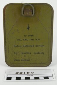
Emergency Ration Tin, AMF, A Gadsen Container
... / To be consumed as found. / 1. HOT CHOCOLATE (if preferred) / Break up... CHOCOLATE (if preferred) / Break up chocolate block and dissolve ...This type of ration tin was issued during the latter part of the Second World War. These rations were issued to every soldier involved in operations and were only to be opened if no other source of food was available.An unopened olive drab Australian Military Forces (AMF) Emergency Ration Tin. There are instructions printed in black ink on the inside surface of the lid. This should read 'INSTRUCTIONS FOR USE / To be consumed as found. / 1. HOT CHOCOLATE (if preferred) / Break up chocolate block and dissolve in hot water. / 2. TEA TABLETS: / Use one per pannikin, adding boiling water and sugar if required. / 3. SALT TABLETS : / To reduce fatigue and cure muscle cramp, take either in water or as desired. Normally stamped in the inside of an opened ration tin would be date, such as '10-44' indicating that it was produced in October 1944. The outside of the tin has printed in black ink 'A.M.F. / EMERGENCY RATION / D (Government broad arrow) D / . The bottom surface of the ration tin has printed in black ink " To be consumed only when no other rations of any kind are procurable. Consumption of this ration must be reported at first opportunity. Instructions for use are printed under cover of container and also on paper slip within can". ration, emergency ration, world war 1 ration -
 Arapiles Historical Society
Tool - Roy SCHMIDT Collection - Handmade Garden Forks (2)
... , and is better suited for fine cultivation, weeding, or breaking up soil... for fine cultivation, weeding, or breaking up soil clods. [2 ...These hand tools are examples of early to mid-20th century garden cultivators, designed for home gardening, small-scale agriculture, or kitchen gardens. Their full-metal construction suggests they were built for durability and could be used in tough soils where wooden-handled tools might break. The minimalist yet practical design would have made them ideal for weeding, soil aeration, or root work in garden beds. Such tools were commonly found in household sheds and were often homemade or locally manufactured by blacksmiths or rural toolmakers. – Roy SCHMIDT resided with his siblings Mabel and Jack at ‘Parklands’ 85 Lake Avenue Natimuk home of Heinrich Friederick ‘Heiny’ & Minna Christina SUDHOLZ nee LANGE and their children Louis, Sophie, Alma, Lena (Roy's Mother), Florence 'Florrie' and Edward ‘Ted’.The image shows two vintage hand garden forks or cultivators, each constructed entirely from metal, including coiled wire handles. The implements are similar in size and style, but differ in tine configuration: [1] Handmade Garden Fork Straight Prongs: Has five straight, flatter tines, more like a rake, and is better suited for fine cultivation, weeding, or breaking up soil clods. [2] Handmade Garden Fork Claw Prongs: Features three thick, curved tines arranged in a spiral and claw-like fashion. These tines are more widely spaced and likely used for loosening tough or compacted soil, or for aerating.gardening -
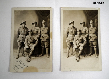 Bendigo Military Museum
Postcard - POSTCARD, PHOTOGRAPHIC 38th BN, C.1916
... Mother describing the photo as a “break up” and he looked like he... Mother describing the photo as a “break up” and he looked like he ...The photo was taken in Amesbury England in the latter part of 1916. The letter is from William Henry Myers No 594 to his Mother describing the photo as a “break up” and he looked like he got a fright in it. It is believed he is 1st on right rear. W.H.Myers No 594 enlisted on 22.2.1916 in B Coy 38th BN age 25 years, embark for England 20.6.1916, embark for France 22.11.1916, made L/Cpl 25.11.1917, WIA 1.10.1918 GSW Left Eye/Face, 19.2.1919 Left Eye “Excised”, RTA 15.5.1919, discharged from the AIF 27.9.1919..1) Post card photo sepia tone rectangular shape shows three soldiers standing and one siting, studio background. Letter in black pencil on the back, front in blue pen. .2) same photo as .1) with no text front or rear..1) on front, “With kind regards Bill”. photographs, 38th bn, b coy -
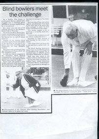 Vision Australia
Document - Text, Blind bowlers meet the challenge
... Bowls Club as part of a three day visit and season break up... Club as part of a three day visit and season break up ...Article profiling Ron Jones, who played at the Jerilderie Bowls Club as part of a three day visit and season break up by the Victorian Blind Bowlers Association. Taking up bowling six years ago, he soon competed at the Australian Blind Bowling championships and was awarded the trophy for the most improved. The Bowling Association does not have its own grounds, so throughout the summer its 41 members played on greens all over Melbourne. The article includes a picture of Ron Jones about to release the ball and Jean Sullivan after releasing a bowl.1 photocopied newspaper article with two imagesnon-fictionelizabeth maxwell, neil maxwell, victorian blind bowling association, ron jones -
 Bendigo Historical Society Inc.
Slide - RALPH BIRRELL COLLECTION: EIG SCHOOL, c1967
... School, Applied Science. Workman using jackhammer to break... jackhammer break rock Kodak EIG School - Ralph Birrell Collection ...EIG School - Ralph Birrell Collection. - Construction of Latrobe Uni. C1967. Bendigo Institute of Technology, Engineering School, Applied Science. Workman using jackhammer to break the rock up.Kodakeducation, tertiary, latrobe university bendigo, eig school - ralph birrell collection. - construction of latrobe uni. c1967. bendigo institute of technology, engineering school, applied science. workman jackhammer break rock -
 Ringwood and District Historical Society
Newspaper, Ringwood East State School 4180: Newspaper Articles 1924 - 1968
... 1927, School break-up 1930. Also a photo from the Mail 21/9/61... 1927, School break-up 1930. Also a photo from the Mail 21/9/61 ...Various newspaper articles on Ringwood East State School. Headings of articles and dates are as follows: Opening Festivies 8/8/24, Ringwood East State School Committee 18/5/27 and 11/5/1927, Ringwood East Ladies Guild 1924, Old Scholar's Club 1934, School Social Held 1924, 1928 and 1934, School Concert 1927, School break-up 1930. Also a photo from the Mail 21/9/61 of the first school Parents Committee Mr & Mrs Hodgkins, Mr Perry, Mr Hann, Mr Meyland, Mr P Klix and Mr Crooks. A hand written note about the purchase of the land from Edward Lindsay and the school was opened by W.H. Everard MLA on 6th August 1924. -
 Robin Boyd Foundation
Document, Frederick Romberg, The Gromboyd Letters Vol 1, 1987
... – the NGV project, the break-up of the partnership in 1963... – the NGV project, the break-up of the partnership in 1963 ...Frederick Romberg wrote a personal record of the Grounds Romberg and Boyd partnership (nicknames Gromboyd) and the subsequent Romberg and Boyd partnership, covering 1953-1971 and with some detail for later years up until 1983. The two volumes contain transcripts of a selection of correspondence between the partners, as well as some explanatory text. The first volume covers the establishment of the partnership in 1953 to 1956-57 when Robin Boyd was Visiting Bemis Professor at Massachusetts Institute of Technology. Volume two continues from 1957 covering all the later years – the NGV project, the break-up of the partnership in 1963, the formation of Romberg and Boyd, Robin Boyd's death and Romberg's years in Newcastle (1965-1975) and his return to Melbourne (see item D270).Bound hard cover booklet, with approx 123 foolscap pages, typed photocopy.Title page has "Suzy Boyd 11.1.87 at Boyds' Canberra Weekend 10.1.87-12.1.87. "Added in another hand 'with Mandie, Penleigh & Suzy'". -
 Robin Boyd Foundation
Document, Frederick Romberg, The Gromboyd Letters Vol 2, 1987
... the later years – the NGV project, the break-up of the partnership... the later years – the NGV project, the break-up of the partnership ...Frederick Romberg wrote a personal record of the Grounds Romberg and Boyd partnership (nicknames Gromboyd) and the subsequent Romberg and Boyd partnership, covering 1953 - 1971 and with some detail for later years up till 1983. The two volumes contain transcripts of a selection of correspondence between the partners, as well as some explanatory text. The first volume covers the establishment of the partnership in 1953 to 1956-57 when Robin Boyd was Visiting Bemis Professor at Massachusetts Institute of Technology (see item D269). Volume two continues from 1957 covering all the later years – the NGV project, the break-up of the partnership in 1963, the formation of Romberg and Boyd, Robin Boyd's death and Romberg's years in Newcastle (1965-1975) and his return to Melbourne.Bound hard cover booklet, with approx 114 foolscap pages, typed photocopy. -
 Warrnambool and District Historical Society Inc.
Original Document, Map: Agricultural area of Ballangeich 1865, 1865
... relates to the breaking up of large runs which the Victorian... relates to the breaking up of large runs which the Victorian ...George Eddington arrived in Australia in 1839 and named and established property in 1841 calling the property Ballangeich after a Pass near his home town of Stirling in Scotland. It is situated 151 miles west of Melbourne and to the south of Mortlake and was originally part of the Mortlake shire, which was proclaimed 26th Jan 1864. Nearest streams are the Hopkins Riverand Lyall and Drysdale creek running through good agricultural land. This map relates to the breaking up of large runs which the Victorian government enabled through selection acts of the 1860's. The previously larger runs which were mainly cattle and sheep based were now more open to closer settlement and a greater variety in farming.The lots range in size from approximately 50 acres to around 600 acres.Some areas are set aside for reserves. By 1886 the population of Ballangeich had grown to around 600 with an hotel, three state schools and a church.Tri weekly coaches ran to Colac, Warrnambool and Camperdown providing access to supplies mail and communication. This map is typical of many which were produced in the 1860's in Victoria during a significant period of Victoria's and Warrnambool district history.Rectangular light card paper with black text showing allotments of land The area is coloured in green with scale at bottom right cornerAt the top: Plan of the Agricultural area of Ballangeich 1865 At the bottom left: Prepared by the Board of Lands & Works in accordance with the Amending Land Act 1865 Lands & Survey Office Melbourne 13th April 1865. With signaturehistory of warrnambool, ballangeich, land surveys victoria 1865, lands act 1865 victoria, ballangeich map 1865 -
Ringwood and District Historical Society
Document, Ringwood and District Horticultural and Garden Club, Ringwood and District Horticultural and Garden Club Syllabus - 1972, 1972
... Meeting. Question Night Dec. 11th Christmas Break up... Annual Meeting. Question Night Dec. 11th Christmas Break up Small ...Ringwood and District Horticultural and Garden Club Syllabus 1972.Small card Ringwood and District Horticultural and Garden Club Syllabus 197__ Monthly Meetings are held in the Public Library, Warrandyte Road, Ringwood, on the Third Monday of each month at 8 pm. (Mrs.) V.H.WILSON, Hon. Secretary 38 William Street, Ringwood Telephone: 870-7458 (Inside) Page One Jan 17th Pressed Flowers Feb. 21st Judging Standards Mar.20th Fuchsias Apr. 17th Native Plants May 15t Indoor Plants June 19th Fruit Tree Pruning Page Two July 17th Toowoomba Festival Aug. 21st Camelias Sept. 18th Bulbs Oct. 16th Vegetables Nov. 20th Annual Meeting. Question Night Dec. 11th Christmas Break up -
 Bendigo Historical Society Inc.
Document - Anne Currie - A Colonial Wife, 1873 to 1916
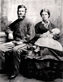
... Pioneer, Anne Currie and her husband John helped open up.... Currie' The diary continued with a few breaks right up lo 1916 ...Pioneer, Anne Currie and her husband John helped open up the area we now know as Lardner or the Drouin area. Anne Currie kept a diary more like a day book of her family's activities throughout their lives. The Diaries were commenced by John on 8th March 1813, but on 28 September of that year there is an entry 'John Currie has tired of keeping a Diary and has handed it over to me - C. Currie' The diary continued with a few breaks right up lo 19162807.11a Photocopy of Catherine and John Currie, photograhped in Melbourne by the famous J.P.Lind prior to journeying to Lardner in November 1875. Albert Currie is the baby aged four months. John is 41 years and Anne Catherine Currie is aged 30 years. 2807.11b Anne Currie - A Colonial Wife. A talk given by Robert Marmion at an Amy Huxtable Memorial Talk. Fifteen typed A4 Pages from the diaries.history, amy huxtable, bendigo, robert marmion, anne currie, albert currie, john currie, lardner drouin -
 Eltham District Historical Society Inc
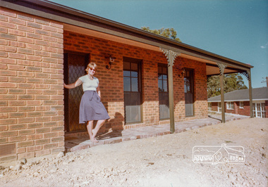
Photograph, 13 Stokes Place, Eltham, December 1980, 1980
... was developed from the break-up of the the orchard owned by Frank Stokes... was developed from the break-up of the the orchard owned by Frank Stokes ...Stokes Place was part of the Stokes Orchard Estate which was developed from the break-up of the the orchard owned by Frank Stokes who lived on the northeast corner of Nyora Road and Eucalyptus Road. His daughter Beryl advised that the Shire had levied a rate assessment on individual parcels of land within the orchard which became unaffordable resulting in its sub-division and sell off. The Stokes Orchard Estate was developed by Macquarie Builders in two stages starting with stage 1 in 1976. Stokes Place was part of Stage 2 in 1979. The Estate was bounded between Nyora Road, Eucalyptus Road, Diosma Road and Stokes Place. The original orchard only just reached the left most portions of Stokes Place and did not go fully up to Diosma, rather to just beyond the extant of Stokes Place. Stokes Place was known within the family as "The Oats" as that is where they grew oats. Frank Stokes moved to Eltham c.1945 after visiting Harold Bird to view his orchard, located diagonally opposite Stokes Orchard from the intersection of Eucalyptus Road, Pitt Street and Nyora Road. It was on Harold Bird's recommendation that Frank purchased the land.The Stokes Orchard Estate collection is typical of housing developments of the late 1970s and 1980s. It was one of the earliest estates in Eltham following the nearby Woodridge Estate development.Digital filestokes place, eltham, stokes orchard, stokes orchard estate, streets, houses -
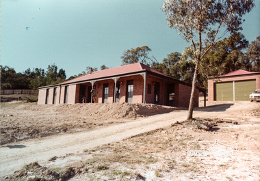
 Eltham District Historical Society Inc
Document, 14 Stokes Place, Eltham: Building plans and contracts, 1979c
... was developed from the break-up of the the orchard owned by Frank Stokes... was developed from the break-up of the the orchard owned by Frank Stokes ...14 Stokes Place was the home of Peter and Carla Vermey. The land was purchased in May 1979 and the home built by Peter and Carla Vermey after the developer, Macquarie Builders went bankrupt. Sold October 2017 by Morrison and Kleeman Real Estate. Stokes Place was part of the Stokes Orchard Estate which was developed from the break-up of the the orchard owned by Frank Stokes who lived on the northeast corner of Nyora Road and Eucalyptus Road. His daughter Beryl advised that the Shire had levied a rate assessment on individual parcels of land within the orchard which became unaffordable resulting in its sub-division and sell off. The Stokes Orchard Estate was developed by Macquarie Builders in two stages starting with stage 1 in 1976. Stokes Place was part of Stage 2 in 1979. The Estate was bounded between Nyora Road, Eucalyptus Road, Diosma Road and Stokes Place. The original orchard only just reached the left most portions of Stokes Place and did not go fully up to Diosma, rather to just beyond the extant of Stokes Place. Stokes Place was known within the family as "The Oats" as that is where they grew oats. Frank Stokes moved to Eltham c.1945 after visiting Harold Bird to view his orchard, located diagonally opposite Stokes Orchard from the intersection of Eucalyptus Road, Pitt Street and Nyora Road. It was on Harold Bird's recommendation that Frank purchased the land.The Stokes Orchard Estate collection is typical of housing developments of the late 1970s and 1980s. It was one of the earliest estates in Eltham following the nearby Woodridge Estate development.Digital file30 digital files scanned from documents provided on loan by Peter and Carla Vermeystokes place, eltham, stokes orchard, stokes orchard estate, streets, houses, peter and carla vermey -
 Eltham District Historical Society Inc
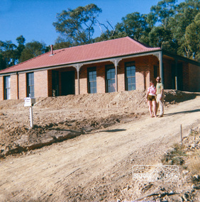
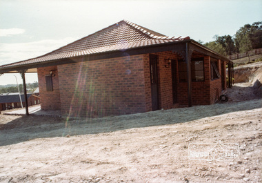
Photograph, 14 Stokes Place, Eltham, April 1980, 1980
... was developed from the break-up of the the orchard owned by Frank Stokes... was developed from the break-up of the the orchard owned by Frank Stokes ...14 Stokes Place was the home of Peter and Carla Vermey. The land was purchased in May 1979 and the home built by Peter and Carla Vermey after the developer, Macquarie Builders went bankrupt. Sold October 2017 by Morrison and Kleeman Real Estate. Stokes Place was part of the Stokes Orchard Estate which was developed from the break-up of the the orchard owned by Frank Stokes who lived on the northeast corner of Nyora Road and Eucalyptus Road. His daughter Beryl advised that the Shire had levied a rate assessment on individual parcels of land within the orchard which became unaffordable resulting in its sub-division and sell off. The Stokes Orchard Estate was developed by Macquarie Builders in two stages starting with stage 1 in 1976. Stokes Place was part of Stage 2 in 1979. The Estate was bounded between Nyora Road, Eucalyptus Road, Diosma Road and Stokes Place. The original orchard only just reached the left most portions of Stokes Place and did not go fully up to Diosma, rather to just beyond the extant of Stokes Place. Stokes Place was known within the family as "The Oats" as that is where they grew oats. Frank Stokes moved to Eltham c.1945 after visiting Harold Bird to view his orchard, located diagonally opposite Stokes Orchard from the intersection of Eucalyptus Road, Pitt Street and Nyora Road. It was on Harold Bird's recommendation that Frank purchased the land.The Stokes Orchard Estate collection is typical of housing developments of the late 1970s and 1980s. It was one of the earliest estates in Eltham following the nearby Woodridge Estate development.Digital fileScanned from a print contained in owner's photo album (81 prints in total digitised)stokes place, eltham, stokes orchard, stokes orchard estate, streets, houses, peter and carla vermey -
 Eltham District Historical Society Inc
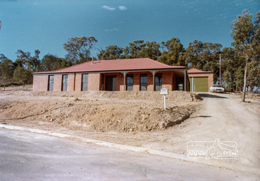
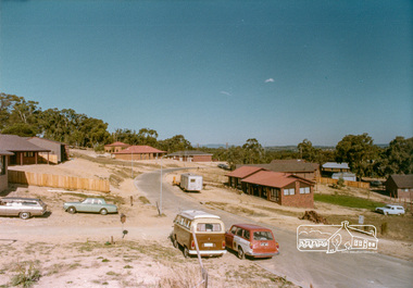
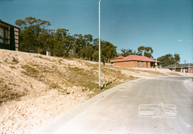
Photograph, Stokes Place, Eltham, April 1980; viewed from near no. 10 looking southeast, 1980
... was developed from the break-up of the the orchard owned by Frank Stokes... was developed from the break-up of the the orchard owned by Frank Stokes ...14 Stokes Place was the home of Peter and Carla Vermey. The land was purchased in May 1979 and the home built by Peter and Carla Vermey after the developer, Macquarie Builders went bankrupt. Sold October 2017 by Morrison and Kleeman Real Estate. Stokes Place was part of the Stokes Orchard Estate which was developed from the break-up of the the orchard owned by Frank Stokes who lived on the northeast corner of Nyora Road and Eucalyptus Road. His daughter Beryl advised that the Shire had levied a rate assessment on individual parcels of land within the orchard which became unaffordable resulting in its sub-division and sell off. The Stokes Orchard Estate was developed by Macquarie Builders in two stages starting with stage 1 in 1976. Stokes Place was part of Stage 2 in 1979. The Estate was bounded between Nyora Road, Eucalyptus Road, Diosma Road and Stokes Place. The original orchard only just reached the left most portions of Stokes Place and did not go fully up to Diosma, rather to just beyond the extant of Stokes Place. Stokes Place was known within the family as "The Oats" as that is where they grew oats. Frank Stokes moved to Eltham c.1945 after visiting Harold Bird to view his orchard, located diagonally opposite Stokes Orchard from the intersection of Eucalyptus Road, Pitt Street and Nyora Road. It was on Harold Bird's recommendation that Frank purchased the land.The Stokes Orchard Estate collection is typical of housing developments of the late 1970s and 1980s. It was one of the earliest estates in Eltham following the nearby Woodridge Estate development.Digital fileScanned from a print contained in owner's photo album (81 prints in total digitised)stokes place, eltham, stokes orchard, stokes orchard estate, streets, houses, peter and carla vermey -
 Eltham District Historical Society Inc
Photograph, 14 Stokes Place, Eltham, April 1980, 1980
... was developed from the break-up of the the orchard owned by Frank Stokes... was developed from the break-up of the the orchard owned by Frank Stokes ...14 Stokes Place was the home of Peter and Carla Vermey. The land was purchased in May 1979 and the home built by Peter and Carla Vermey after the developer, Macquarie Builders went bankrupt. Sold October 2017 by Morrison and Kleeman Real Estate. Stokes Place was part of the Stokes Orchard Estate which was developed from the break-up of the the orchard owned by Frank Stokes who lived on the northeast corner of Nyora Road and Eucalyptus Road. His daughter Beryl advised that the Shire had levied a rate assessment on individual parcels of land within the orchard which became unaffordable resulting in its sub-division and sell off. The Stokes Orchard Estate was developed by Macquarie Builders in two stages starting with stage 1 in 1976. Stokes Place was part of Stage 2 in 1979. The Estate was bounded between Nyora Road, Eucalyptus Road, Diosma Road and Stokes Place. The original orchard only just reached the left most portions of Stokes Place and did not go fully up to Diosma, rather to just beyond the extant of Stokes Place. Stokes Place was known within the family as "The Oats" as that is where they grew oats. Frank Stokes moved to Eltham c.1945 after visiting Harold Bird to view his orchard, located diagonally opposite Stokes Orchard from the intersection of Eucalyptus Road, Pitt Street and Nyora Road. It was on Harold Bird's recommendation that Frank purchased the land.The Stokes Orchard Estate collection is typical of housing developments of the late 1970s and 1980s. It was one of the earliest estates in Eltham following the nearby Woodridge Estate development.Digital fileScanned from a print contained in owner's photo album (81 prints in total digitised)stokes place, eltham, stokes orchard, stokes orchard estate, streets, houses, peter and carla vermey -
 Eltham District Historical Society Inc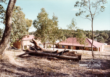
Photograph, 14 Stokes Place, Eltham, April 1980, 1980
... was developed from the break-up of the the orchard owned by Frank Stokes... was developed from the break-up of the the orchard owned by Frank Stokes ...14 Stokes Place was the home of Peter and Carla Vermey. The land was purchased in May 1979 and the home built by Peter and Carla Vermey after the developer, Macquarie Builders went bankrupt. Sold October 2017 by Morrison and Kleeman Real Estate. Stokes Place was part of the Stokes Orchard Estate which was developed from the break-up of the the orchard owned by Frank Stokes who lived on the northeast corner of Nyora Road and Eucalyptus Road. His daughter Beryl advised that the Shire had levied a rate assessment on individual parcels of land within the orchard which became unaffordable resulting in its sub-division and sell off. The Stokes Orchard Estate was developed by Macquarie Builders in two stages starting with stage 1 in 1976. Stokes Place was part of Stage 2 in 1979. The Estate was bounded between Nyora Road, Eucalyptus Road, Diosma Road and Stokes Place. The original orchard only just reached the left most portions of Stokes Place and did not go fully up to Diosma, rather to just beyond the extant of Stokes Place. Stokes Place was known within the family as "The Oats" as that is where they grew oats. Frank Stokes moved to Eltham c.1945 after visiting Harold Bird to view his orchard, located diagonally opposite Stokes Orchard from the intersection of Eucalyptus Road, Pitt Street and Nyora Road. It was on Harold Bird's recommendation that Frank purchased the land.The Stokes Orchard Estate collection is typical of housing developments of the late 1970s and 1980s. It was one of the earliest estates in Eltham following the nearby Woodridge Estate development.Digital fileScanned from a print contained in owner's photo album (81 prints in total digitised)stokes place, eltham, stokes orchard, stokes orchard estate, streets, houses, peter and carla vermey