Showing 89 items
matching canterbury railway station
-
 Surrey Hills Historical Society Collection
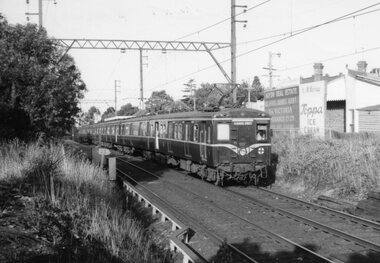
Unknown - Digital photo, George L Coop, Harris train at Mont Albert railway station c 1964, c1964
The train is headed towards Surrey Hills station. In the background are the Hamilton Street shops with advertising posters on their rear walls. The donor George Lister Coop was about 27 years of age when he took this photo. It is one of a small series of photos donated by him that relate to Mont Albert and Surrey Hills stations. He has always had an interest in railways and there are other examples of his documentation of railway history in other collections contributing to this database. A black & white photo of a Harris train destined for Flinders Street that has passed through Mont Albert station, which can just be seen in the background. Behind the train on the rear walls of buildings are advertising for Haydn Real Estate and K&M Murray selling Toppa Ice Cream.advertising signs, george l coop, mont albert station, trains, haydn real estate, toppa ice cream, k & m murray, hamilton street shops -
 Surrey Hills Historical Society Collection
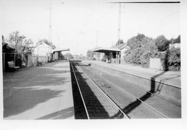
Digital photo, George L Coop, Mont Albert Railway Station c 1956, c1956
The donor George Lister Coop was about 19 years of age when he took this photo. It is one of a small series of photos donated by him that relate to Mont Albert and Surrey Hills stations. He has always had an interest in railways and there are other examples of his documentation of railway history in other collections contributing to this database. This documents the original building on the northern platform of the Mont Albert station. The railway line was extended out to Lilydale with work commencing in 1882. It is not known exactly when the Mont Albert station was built, but it opened in 1890. It is presumed that this building was demolished when the third line was constructed in 1971. At this time the nearby Surrey Hills original station buildings were demolished.A black & white photo of Mont Albert station taken from the north platform adjacent to High Street, looking towards Box Hill. It clearly shows the bend in the line beyond the platforms. it also shows both the original buildings; the one on the north side having been demolished. There is a lady on the south platform adjacent to Hamilton Street. The roof line only of one of the Hamilton Road shops can be seen.george lister coop, mont albert station, 1956, hamilton street shops -
 Surrey Hills Historical Society Collection
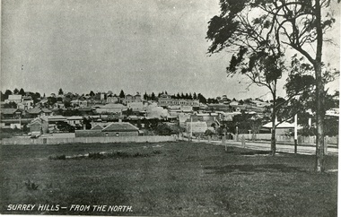
Photograph, Surrey Hills from north of Montrose Street 1907-1911
In the foreground is Dr Blakie's first surgery, later the Police Station, then a Service station. Behind and to the left are the two railway station buildings. On the horizon and in front of the pine trees is 'Montalto', home of the Hansen family, later Dr Box (demolished). Two storey terrace of shops in front of this is Hansen's Terrace. In centre, note smoke from steam train. On corner of Guildford Rd is a Gas Lamp. The first trees have been planted in Union Road and are protected with stout wood surround.Black and white photograph of a view of Surrey Hills. Written on the bottom left hand side "SURREY HILLS - FROM THE NORTH". In the foreground are two trees on the right hand side before a view leading up the hill. dr blakie, police station, hansen terrace, dr box, montalto, guildford rd, gas lamp, union road -
 Surrey Hills Historical Society Collection
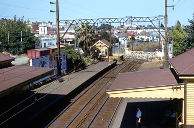
Work on paper - Digital photograph, George L Coop, Surrey Hills railway station c1958, c1958
The donor George Lister Coop was about 21 years of age when he took this photo. It is one of a small series of photos donated by him that relate to Mont Albert and Surrey Hills stations. He has always had an interest in railways and there are other examples of his documentation of railway history in other collections contributing to this database. R J Mercer was the butcher at 112 Union Road. This property has a long history of being a butcher's shop beginning from c1904. He took over from Edward Lloyd in 1951. Spotless Dry Cleaners were at 104 Union Road.This is an important photo as there are few known colour images of the station prior to the installation of the third line in the early 1970s, which resulted in the demolition of the station built in 1883. It is also significant as a record of the housing along the south side of Stirling Crescent which was later replaced by light industry.A digital colour photo of Surrey Hills railway station taken from the overhead pedestrian footbridge looking towards Canterbury. Both tracks and the verandas on either side of the line can be seen, as can the railway gates in the open position and the signal box, beside which is a large palm tree. A section of red goods vans are positioned in the adjacent goods yard. Some of the businesses and advertising hoardings in Union Road can be seen in the background. These include A Doubleday (real estate agents), R J Mer..., grocer, baker, Spotless Dry Cleaning, Robur tea and Lipton tea (part of only). A number of the Edwardian houses along the south side of Stirling Crescent are also seen.george l coop, surrey hills railway station, goods yard, real estate agent, a doubleday, grocer, baker, union road, stirling crescent, spotless dry cleaning, r j mercer, butcher -
 Canterbury History Group
Photograph - Canterbury station buildings, c1966
... melbourne Canterbury Canterbury station Canterbury Road Railway ...Ticket box and restrooms viewed from the north c1966. Black and white photographcanterbury, canterbury station, canterbury road, railway stations -
Canterbury History Group
Photograph - Canterbury station buildings, c1966
... melbourne Canterbury Canterbury station Canterbury Road Railway ...General view taken from the west, three workmen in foreground. Black and white photographcanterbury, canterbury station, canterbury road, railway stations -
Canterbury History Group
Photograph - Panorama of Canterbury Station
... melbourne Canterbury Canterbury Station Goldings Hall Railway ...Part one of a set of four sepia photographs which combine to provide a panorama of Canterbury station and its surrounds.canterbury, canterbury station, goldings hall, railway employee -
Canterbury History Group
Photograph - Panorama of Canterbury Station
Part two of a set of four sepia photographs which combine to provide a panorama of Canterbury station and its surrounds.canterbury, railway carriages, baptist church, canterbury buildings, canterbury road -
Canterbury History Group
Document - New Signal Box At Canterbury Station, 1890
... Canterbury Station Notification from the Victorian Railways ...Notification from the Victorian Railways that the new signal box at Canterbury will be brought into use 5 August 1890canterbury, canterbury road, victorian railways, signal boxes, canterbury station -
Canterbury History Group
Document - Regulation 180, 24 February 1888
... melbourne Canterbury Canterbury Station Canterbury Road Victorian ...Memo from the Victorian Railways of proceedures to be followed before a "Line Clear" can be given.canterbury, canterbury station, canterbury road, victorian railways, railway lines -
Canterbury History Group
Document - Memo for Signal Box Inspector, 13 August 1890
... melbourne Canterbury Canterbury Station Victorian Railways Signal ...Victorian Railways memo certifying that Thos. Coughlin has been instructed in all the duties of Canterbury Signal Boxcanterbury, canterbury station, victorian railways, signal boxes, coughlin> thos. -
Canterbury History Group
Photograph - At the station , Canterbury Victoria, Real Photo Series M 606, c1915
... melbourne Canterbury Canterbury Station Canterbury Road Steam Trains ...Photocopy of photo of a steam train at Canterbury Station, c1915canterbury, canterbury station, canterbury road, steam trains, railway lines -
Canterbury History Group
Photograph - New Overpass, 1968
... melbourne Canterbury Canterbury Road Canterbury Station Trains ...Photocopy of a train crossing on the up track of the Canterbury Road overpasscanterbury, canterbury road, canterbury station, trains, railway crossings -
Canterbury History Group
Document - Reminiscences, Munday, Bill
Some memories of Bill Munday of growing up in Canterbury from approx. 1906canterbury, mangarra road, horse drawn vehicles, moran and cato, fire station, canterbury road, laundries, salvation army corps, malones hotel, canterbury scot troop, geo carnell upholsterers, delivery vehicles, danks family, shenley street, outer circle railway, lifestyle -
Canterbury History Group
Document - Station Buildings at Canterbury, October 1899
... melbourne Canterbury Canterbury Station Plans Railway Stations ...Drawing for Contract no.8826. Railway buildings at Canterbury for Victorian Railways 1899.canterbury, canterbury station, plans, railway stations, railway place, railway lines, victorian railways, canterbury road -
Canterbury History Group
Photograph - Photocopy of train tickets relating to Canterbury
... melbourne Canterbury Canterbury Station Tickets Canterbury Road ...Coloured photocopy of 24 old train tickets relating to Canterburycanterbury, canterbury station, tickets, canterbury road, victorian railways -
Canterbury History Group
Document - Canterbury. Provision of Railway Bridge - Up Line, Office of Chief Traffic Manager, 9/09/1968 12:00:00 AM
... melbourne Canterbury Canterbury Station Canterbury Road Victorian ...Notification from Victorian Railways of the new railway bridge being opened for the Up Line service on Sunday 15 September 1968canterbury, canterbury station, canterbury road, victorian railways, railway bridges, railway lines, trains -
Canterbury History Group
Map - Victorian Railways East Camberwell to Laburnum. Diagram No.3' 58, 1/05/1958 12:00:00 AM
... melbourne Canterbury Canterbury Station Victorian Railways Railway ...Diagram showing proposed signal and interlocking arrangements for the East Camberwell to Laburnam line 1958canterbury, canterbury station, victorian railways, railway lines -
Canterbury History Group
Newspaper, Canterbury Courier, Early history of Canterbury and District
A series of reminiscences, stories and pictures depicting events and people in the district and their celebrations. Many names of early Canterbury identities and landowners and their streets.A series of articles from the Canterbury Courier reprinted in book form. 32 pages; A4. A series of reminiscences, stories and pictures depicting events and people in the district and their celebrations. Many names of early Canterbury identities and landowners and their streets.canterbury, canterbury station, shrublands, emulation hall, banks, shops, lowe> j. w., swan> c. r., rochester road, logans paddock, morrison> crosbie, empire day, outer circle railway, monomeath, bennett> g j, camm> a, scott> g c, hassett> p -
 Ringwood and District Historical Society
Book, Elizabeth Dole Porteus, Let's Go Exploring: The Life Of Stanley D. Porteus - Hawaii's Pioneer Psychologist, 1991
White hard covered book. Biography by daughter-in-law of Stanley Porteus, pioneer of modern psychology and one-time resident of Ringwood, Victoria. SUMMARY NOTES. Stanley David Porteus was born in Box Hill, Victoria, Australia in 1883, the only son of a Methodist minister. Like other now large suburbs of Melbourne such as Canterbury, Mitcham and Ringwood, Box Hill was a mere village. Each was surrounded by bush. He grew up like most Australian boys with a love of sport and, although lightly built, did quite well at Australian Rules football and was above average at cricket. He became a schoolteacher with the Victorian Education Department. Promotion within the department depended on experience gained at teaching in tiny rural schools so he applied for such a position at Glenaladale, on the Dargo Road, some 35 miles north west of Bairnsdale. He walked about 6 miles from the nearest railway station at Fernbank to find the school surrounded by virgin forest with only one dwelling in sight. Attached to the school were lean-to rooms that were to be his residence for the next 2 ½ years. He was fascinated by the nearby Den of Nargun and Bull Creek, which joined the Mitchell River in a deep gorge containing a profusion of rainforest vegetation. While at Glenaladale, he met Frances Evans who became his wife. To seek promotion, he left Glenaladale and taught at Leneva and Benambra. While at the latter school, he learned of a position becoming available as superintendent of special schools in Melbourne. As the available means of transport, coach and horses to Bairnsdale, then by train to Melbourne, would not get him to Melbourne before the close of applications, he borrowed a bicycle and rode through the bush to his in-laws home at Lindenow and thus made it before the deadline. He was successful in his application and it set him on a course that lead to him becoming Australia's first Clinical Psychologist. His work, particularly, the development of the Porteus Maze Test, attracted the attention of American educators and he was offered an appointment for a year at Vineland Training School in New Jersey. On a stopover in Honolulu, he was impressed to the extent that he expressed a desire to work there. Not the least of its attractions was the mix of races that offered opportunities to study psychological differences, if any, between various races. His wish was to be granted unexpectedly as he was, in 1919, invited to Honolulu to set up a Psychological and Psychopathic Clinic at the University of Hawaii. From his home in the hills north of Honolulu, on December 7th 1941, he saw the Japanese attack on Pearl Harbour. He lived there until his death in about 1980. -
 Canterbury History Group
Book, Carroll, Brian, Camberwell Sketchbook, 1978
... Mansions Kugelmann> Ludwig Canterbury Post Office Railway Stations ...A collection of drawings and notes on 26 historical places in the Camberwell and Canterbury area. The notes include history of Canterbury shops, Fairholme, Camberwell Station, Hartwell Station, Camberwell Tram Depot, Frognall, Camberwell Grammar, Fintona.56 pages; illustratedA collection of drawings and notes on 26 historical places in the Camberwell and Canterbury area. The notes include history of Canterbury shops, Fairholme, Camberwell Station, Hartwell Station, Camberwell Tram Depot, Frognall, Camberwell Grammar, Fintona.canterbury, camberwell, hartwell, maling road, canterbury mansions, kugelmann> ludwig, canterbury post office, railway stations, balwyn road, shrublands, frognall, cullymont, monomeath avenue, schools -
Canterbury History Group
Document - Thematic Environmental History, Built Heritage, 1/05/2012
Thematic Environmental Heritage. Final document produced, after community consultation, for the City of Boroondara by Built Heritage242 pages city of boroondara, back yards, canterbury, churches, cottages, dairies, danks family, elgar survey, exploration, frognall, goldings boot factory, maling road, malone's hotel, maps, masonic lodges, national parks, native plants, outer circle railway line, police stations, post offices, railways, rochester road, schools, shrublands, soldiers memorial hall, sport, telephone exchanges, theatres, transport, wildlife, canterbury road, land subdivisions, parks and reserves -
Canterbury History Group
Document - Comments on Boroondara Thematic Environmental History Draft document, Canterbury History Group, 1/08/2011 12:00:00 AM
... Stations Canterbury Gardens Railways Document Comments ...Comments by some concerned members of the Canterbury community regarding issues relating to Canterbury resulting from a careful study of the draft consultation document prepared for the City of Boroondara.canterbury, visions of a village, education, libraries, stationmasters house, petrol stations, canterbury road shopping centre, maling road shopping centre, theatres, police stations, canterbury gardens, railways -
Canterbury History Group
Map - Victorian Railways, Canterbury, Drainage Plan, cc1910
Drainage plan around Canterbury Station, Canterbury Road and Maling Road .5 pages of photocopies from the Public Record Officecanterbury, canterbury road, maling road, canterbury station, drainage, stormwater channels -
Canterbury History Group
Letter - Request to purchase land from the Victorian Railways, 1937 - 1939
... Canterbury Canterbury Road Canterbury Station Victorian ...Collection of letters and drawings between A.D.Jackson and the Victorian Railways, relating to the purchase of land 1937 - 1939canterbury, canterbury road, canterbury station, victorian railways, jackson> a.d., pharmacies, car parks -
 Melbourne Tram Museum
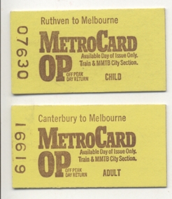
Ephemera - Ticket/s, Victorian Railways, "MetroCard", c August 1980
Ticket - "MetroCard" - printed yellow on both sides - paste board - Edmondson style, Off peak Metro card, available on both the train and MMTB Trams within the City Section. 161.1 - Child - Ruthven to Melbourne, Ticket No. 07630 161.2 - Adult - Canterbury to Melbourne, Ticket No. 16619 and 16628 161.3 - Child - Sandringham to Melbourne, Ticket No. 03792 See Reg Item 3003 for a block or bundle of this type of ticket issued from Seddon Station. For more details see http://www.robx1.net/victkt/pre1981/html/1980.htm - accessed 7/11/2018.trams, tramways, tickets, vr, melbourne, metrocard -
 Ringwood and District Historical Society
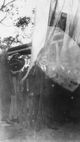
Photograph, Opening Heathmont Railway Station in May 1926, 1926
Opening Heathmont Railway Station in May 1926. The photo shows Herman Pump (centre) and Bill Everard MLA (left), at the gate at the entrance to the railway platform. The Station building was located on the west side of the tracks, near the corner of Heathmont and Canterbury Roads. At the officially opening, the ribbon was cut by Louise Pump, wife of Herman. -
 Ringwood and District Historical Society
Document - Research Notes, Richard Carter, Land Subdivisions in Ringwood 1890-1950
Handwritten table listing main local pre-1950s subdivisions in the Ringwood area, with estate names, streets, number of allotments for sale, and where known, vendor agent, LP (Lodged Plan) title registration number, and auction/sale date, some with sale price.Pg1 RINGWOOD STATION ESTATE LP3070 (Year?) Station Street, William Street (now Kendall Street), Wantirna Road, Station Street Pg1 RINGWOOD TOWNSHIP ESTATE LP5577 (1913) Station Road (now Warrandyte Road), Pratt Street (part now Aird Street), Whitehorse Road Pg2 RINGWOOD ORCHARD ESTATE LP4315 (1914) Brysons Road, Hillcrest Road, Anzac Avenue, Sulva Road Pg3 RINGWOOD RAILWAY ESTATE LP7522 (1918) Whitehorse Road (now Mount Dandenong Road), Dublin Road, Freeman Street, Patterson Street, Bona Street Pg4 THE RINGWOOD ESTATE LP7578 (1919) Warrandyte Road, Hobart Street, Paxton Street, Arnold Street Pg5 GARDEN FARMS ESTATE (LP?) (1919) Canterbury Road, Armstrong Road, Bungalook Road, Orchard Road, Bayswater Road (now Mountain Highway) Pg6 THE RINGWOOD ESTATE (SECOND SUB-DIVISION) LP7604 (1919) Warrandyte Road, Tamar Street, Derwent Street, Mersey Street Pg7 RINGWOOD STATION ESTATE LP7703 (1919) Bedford Road, Williams Grove (now Lena Grove) Pg8 RINGWOOD TOWNSHIP ESTATE LP8198 (1919) Wantirna Road, Ellison Street, Haig Street, Greenwood Avenue Pg9 EASTFIELD ESTATE (LP?) (1920) Eastfield Road, Longview Road, Pleasant Rise, The Mount Pg10 ELECTRIC RAILWAY ESTATE RINGWOOD LP9473 (1922) Campbell Street, Myrtle Avenue, George Street (now Tudor Court), Henry Street (now Myrtle Avenue), Williams Grove (now Lena Grove) Pg11 RINGWOOD PARK ESTATE LP7884 (1922 - two stages) Wonga Road (now Loughnan Road), William Street, Andrew Street, Harrison Street Pg12 HEATHMONT STATION ESTATE LP11009 (Date? - after 1922) Lisgoold Street, Viviani Crescent, Balrour Avenue, Station Street (now part Heathmont Road and part Wainui Street) Pg13 RINGWOOD RAILWAY ESTATE LP10507 (1923) Whitehorse Road, Sherbrooke Avenue, Burwood Avenue, Bonview Avenue, Heatherbrae Avenue, Grant Crescent Pg14 GARDEN HOMES ESTATE (LP?) (1923) Mullum Road, The Centreway, Wattle Crescent (now Wattle Avenue) Reserve Crescent (now Reserve Road) Pg15 DUBLIN ROAD ESTATE LP11993 (1923) Alexandra Road, Vonadawn Avenue, Green Street, Wood Street, Howard Avenue, Bedford Road, Dublin Road Pg16 CARLINGA ESTATE RINGWOOD LP9620 (1923) Bourke Street, Bond Street, Ringwood Street Pg17 PRATT'S JUNCTION ESTATE (LP?) (1923) Junction Street, Georges Road, Oliver Street, Whitehorse Road Pg18 EAST RINGWOOD ESTATE LP10492 (1923) Bona Street, Patterson Street, Miller Grove, Fairview Avenue, Eastfield Road, Whitehorse Road (now Mount Dandenong Road) Pg19 COLEMAN'S HEATHMONT ESTATE LP9974 (1923) Canterbury Road, Bedford Road, Alvena Crescent, Coleman Street, Leonard Street (now Royal Avenue) Pg20 RINGWOOD HEIGHTS ESTATE LP10506 (1924) Whitehorse Road, Bonview Avenue, Grant Crescent, Hillcrest Avenue, Heatherbrae Avenue, Margaret Street, Mary Street Pg21 EAST RINGWOOD STATION ESTATE LP10551 (1924) Knaith Road, Wenwood Street, Lois Street, Victoria Street, Station Street (now Railway Avenue) Pg22 GRAND VIEW ESTATE LP11019 (1924) Whitehorse Road, Rupert Street, Herbert Street, Leonard Street Pg23 RINGWOOD RAILWAY ESTATE & RINGWOOD HEIGHTS ESTATE - FINAL SECTIONS LP10506 & LP10507 (1924) Whitehorse Road, Sherbrooke Avenue, Burwood Avenue, Bonview Avenue, Heatherbrae Avenue, Margaret Street, Mary Street, Grant Crescent Pg24 RINGWOOD EAST ELECTRIC STATION ESTATE (LP?) (1924) Railway Parade (now Patterrson Street), Federal Road, Howship Avenue (part now French Street), Dublin Road, Rosedale Crescent Pg25 BEDFORD PARK (now Ringwood Secondary College) (LP?) (1924) Bedford Road, Adams Street, Anderson Street, Joyce Street, Graham Road Pg26 CROWN JEWEL ESTATE LP11645 (Private sales after 1924) Mount Dandenong Road, Mirabel Avenue, Valda Avenue, Evon Avenue, Velma Grove Pg27 GRAND CENTRAL ESTATE LP10917 (1925) Heathmont Road, Great Ryrie Street, Douglas Street, Garden Street, Bellevue Avenue Pg28 RINGWOOD (unnamed estate - 1926) Nelson Street, Seymour Street, Whitehorse Road Pg29 EAST RINGWOOD RAILWAY STATION ESTATE (YEAR? - 25 shops 60 villas) Railway Avenue, Dublin Road, Lawrence Grove, Stanley Avenue, Knaith Road Pg30 CHARM VIEW ESTATE (LP?) (year? - after 1926) Canterbury Road, Heathmont Road, Dickasons Road, Bennjett Avenue, Orchid Street Pg31 SUNBEAM ESTATE LP12150 (Circa 1925) Govt Road (now Old Lilydale Road), Sunbeam Avenue, Holland Road, Everard Street (now Everard Road) Pg32 FAIRVIEW ESTATE EAST RINGWOOD LP10853 (Circa 1924) Eastfield Road, Patterson Street, Margaret Street (now Short Street) Pg33 EAST RINGWOOD TOWNSHIP ESTATE LP3025 (Circa 1924 - 35 allotments) Mount Dandenong Road, Grey Street, Eastfield Road Pg34 EAST RINGWOOD TOWNSHIP ESTATE LP3025 (Circa 1924 - 49 allotments) and STATE SCHOOL ESTATE (26 allotments) and EAST RINGWOOD STATION ESTATE (14 shop sites) Mount Dandenong Road, Grety Street, Dunn Street, Eastfield Road, King Street, Holland Road, Dublin Road, Patterson Street, Bona Street Pg35 EAST RINGWOOD CENTRAL ESTATE LP17004 (1948) Knaith Road, Shasta Avenue, Talofa Avenue, Russet Road, Dublin Road Pg36 WARE ESTATE LP43360 (1958) Ware Crescent, Davey Drive, Grey Road (now Grey Street), Mount Dandenong Road Pg37 Lot 57 Kendall Street LP3070 (1939) £75.0.0 Pg37 Lot 14 LP7346 (year?) £225 Pg37 Lot 8 WHITE HORSE ESTATE LP14010 (year?) Maroondah Hwy, Seymour Street £98.9.0 Pg37 Lots 4-14 incl. LP10902 (year?) £300 Pg37 Lots 69&70 LP2216 (1939) Bedford Road, Pitt Street £500 Pg37 Lots 60&70 LP2216 (year?) £460 Pg37 MOUNTAIN VIEW ESTATE LP10902 (1936) Lots 1&2, 19-22 Wantirna Road, Daisy Street £50 Pg38 RAILWAY STATION ESTATE RINGWOOD EAST LP7522 (1925) Lots 16 to 19 £250 Pg38 RINGWOOD PARK ESTATE (LP?) (1924) Lot 112 Munro Street £230 Pg38 RINGWOOD TOWNSHIP ESTATE (LP?) (1925) Lot 57 Wantirna Road £850 Pg38 ELECTRIC RAILWAY ESTATE LP9473 (1925) Lot 98 & 99 £180 (30/- foot) Pg38 ELECTRIC RAILWAY ESTATE LP9473 (year?) Lot 100 £233.12.6 incl improvements (£2.12.6 foot) Pg38 Lot 22&23 Bedford Road Heathmont (LP & year?) £675 incl improvements Pg39 Lot 9 Mullum Mullum Road LP8221 (1923) £150 Pg39 Lot 27 Haig Street LP8198 (1925) £825 Pg39 Lot 56 Haig Street cnr Wantirna Road LP8198 (1923) £171 Pg39 Lots 3 & 4 Loughnan Road LP9626 (192?) £147 Pg39 Lots 98 & 99 Myrtle Avenue LP9473 (1925) £180 Pg39 Lots 80 & 81 Myrtle Avenue LP9473 (1929) £150 Pg39 Lot 30 Sherbrooke Avenue LP10507 (1926) £700 incl improvements Pg40 Lot 10 (year?) LP7703 £750 Pg40 Lot 36 (year?) LP7522 £25 Pg40 Lot 38 Pitt Street LP2216 (year?) £350 Pg40 Lot 7 Dublin Road cnr Green Street LP11993 (year?) £300 -
Canterbury History Group
Photograph - Street view of the laneway between shop nos 121 and 119 Maling Road, Jan Pigot, 27/03/1993 12:00:00 AM
Coloured photograph of a street view of the laneway between shop nos 121 and 119 Maling Road. The elevated railway can be seen in the distancecanterbury, maling road, shops, laneways, railway stations