Showing 71 items
matching closed 1960s
-
 Falls Creek Historical Society
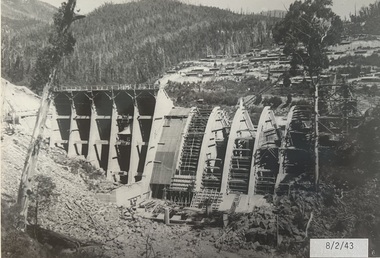
Photograph - Bogong Alpine Village 1943
The images in the Bogong Village Collection were displayed in Bogong Jack’s Tavern for over 20 years and were donated to the Falls Creek Museum when the Tavern closed in 2021. In 1939, the State Electricity Commission of Victoria established a field headquarters at Bogong to house workers and their families for the Kiewa Hydroelectric Scheme which ran from the 1930s to the 1960s. The workmen's camp was originally started with tents and was called Junction Camp. By 1947, the village supported 300 workers and their families. It included 40 houses, a hostel for single staff, a post office, a police station, a medical centre, and a primary school. The staff hostel was known as Kiewa House. At the completion of the Scheme, in the 1960s, the village was opened to public/tourism use. In 1968 the Victorian Education Department acquired the camp buildings and four houses from the State Electricity Commission of Victoria to establish an Outdoor Education Centre which operated for over 50 years. The Kiewa Hydroelectric Scheme was privatized in the 1990s and sold to Southern Hydro, before being acquired by AGL in 2005. In 2023 the Grollo Group signed a 73 year sublease on Bogong Village and has plans for its redevelopment as a workers’ village.These images are significant because they capture the development of Bogong Village as an important element of the Kiewa Hydroelectric Scheme in Victoria.A collection of seven black and white images capturing the development of Bogong Alpine Village and the Pretty Valley area during 1943.bogong alpine village, bogong high plains, bogong 1943 -
 Falls Creek Historical Society
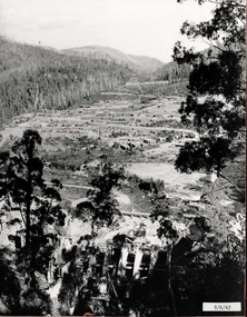
Photograph - Bogong Alpine Village 1942
The images in the Bogong Village Collection were displayed in Bogong Jack’s Tavern for over 20 years and were donated to the Falls Creek Museum when the Tavern closed in 2021. In 1939, the State Electricity Commission of Victoria established a field headquarters at Bogong to house workers and their families for the Kiewa Hydroelectric Scheme which ran from the 1930s to the 1960s. The workmen's camp was originally started with tents and was called Junction Camp. By 1947, the village supported 300 workers and their families. It included 40 houses, a hostel for single staff, a post office, a police station, a medical centre, and a primary school. The staff hostel was known as Kiewa House. At the completion of the Scheme, in the 1960s, the village was opened to public/tourism use. In 1968 the Victorian Education Department acquired the camp buildings and four houses from the State Electricity Commission of Victoria to establish an Outdoor Education Centre which operated for over 50 years. The Kiewa Hydroelectric Scheme was privatized in the 1990s and sold to Southern Hydro, before being acquired by AGL in 2005. In 2023 the Grollo Group signed a 73 year sublease on Bogong Village and has plans for its redevelopment as a workers’ village.These images are significant because they capture the development of Bogong Village as an important element of the Kiewa Hydroelectric Scheme in Victoria.A collection of four black and white images capturing the development of Bogong Alpine Village and the Pretty Valley area during 1942.bogong alpine village, bogong high plains, bogong 1942 -
 Falls Creek Historical Society
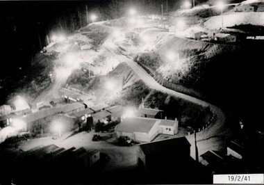
Photograph - Bogong Alpine Village 1941
The images in the Bogong Village Collection were displayed in Bogong Jack’s Tavern for over 20 years and were donated to the Falls Creek Museum when the Tavern closed in 2021. In 1939, the State Electricity Commission of Victoria established a field headquarters at Bogong to house workers and their families for the Kiewa Hydroelectric Scheme which ran from the 1930s to the 1960s. The workmen's camp was originally started with tents and was called Junction Camp. By 1947, the village supported 300 workers and their families. It included 40 houses, a hostel for single staff, a post office, a police station, a medical centre, and a primary school. The staff hostel was known as Kiewa House. At the completion of the Scheme, in the 1960s, the village was opened to public/tourism use. In 1968 the Victorian Education Department acquired the camp buildings and four houses from the State Electricity Commission of Victoria to establish an Outdoor Education Centre which operated for over 50 years. The Kiewa Hydroelectric Scheme was privatized in the 1990s and sold to Southern Hydro, before being acquired by AGL in 2005. In 2023 the Grollo Group signed a 73 year sublease on Bogong Village and has plans for its redevelopment as a workers’ village.These images are significant because they capture the development of Bogong Village as an important element of the Kiewa Hydroelectric Scheme in Victoria.A collection of four black and white images capturing the development of Bogong Alpine Village. They depict development of the new village, the surrounding area and some staff members during 1941.bogong alpine village, bogong high plains, bogong 1941 -
 Eltham District Historical Society Inc
Photograph - Digital Photograph, Alan King, St Andrews Anglican Church, St Andrews, 30 January 2008
... the mid-1960s the church closed, then fell into disrepair. So... the mid-1960s the church closed, then fell into disrepair. So ...Built c.1868, St Andrew’s Anglican Church is Nillumbik Shire’s oldest timber church and is historically, socially, and spiritually significant to the Shire of Nillumbik. The church is historically significant because it may have given its name 'St Andrews' to the town (another suggestion is that the name came from the local hotel), it is also historically significant as one of only four buildings that remain from the Caledonian goldfields era of Queenstown (now St Andrews) and one of only a handful of buildings that survived the 1960s bushfires. The church is historically, socially, and spiritually significant because it has played an important part in community life for more than 150 years; a proposal to move the church in 1984 met with strenuous opposition. Much of the fires on Black Saturday 2009 were the north of the town. The town itself remained intact - as did this heritage building. Covered under Heritage Overlay, Nillumbik Planning Scheme. National Trust of Australia (Victoria) Local significance Published: Nillumbik Now and Then / Marguerite Marshall 2008; photographs Alan King with Marguerite Marshall.; p69 The St Andrews Anglican Church and former St Andrews Primary School, are two reminders of the district’s early days, when it was founded on gold. St Andrews, then called Queenstown, was the earliest goldfield in the Caledonia Diggings.1 It was the Upper Diamond Gold Mining and Administrative Centre, with 3000 miners. Queenstown was also the seat of the Court of Petty Sessions. The church and school then stood close to European and Chinese stores, three hotels, a brewery and a quartz mill.2 In 1861, Queenstown was officially proclaimed a township. From 1865, the name Queenstown was interchangeable with St Andrews, until 1952, when the town was officially named St Andrews. As gold declined from the early 1880s, Queenstown changed dramatically into a settlement of small farms. St Andrew’s Anglican Church, built in 1868, is the Shire’s oldest timber church and possibly gave its name to the township.3 The small timber church was opened on November 1, 1869, by the Dean of Melbourne. Anniversary tea meetings helped raise funds, and in 1889, a three-bedroom parsonage was built alongside. In 1910, the vicar, the Rev Selwyn Chase (and friend of the Scouting Movement’s founder, Baden Powell), established the 1st Queenstown Scout Troop, only two years after Scouting began in Australia. The church was important to the lives of many local residents who were baptised, married and had funeral services there. But by the 1950s the population had decreased and so did the weekly attendances. Around the mid-1960s the church closed, then fell into disrepair. So in the mid 1980s it was sold to the Education Department and was under threat of relocation or demolition. However this caused such opposition from locals,4 that instead, the Anglican church leased it as part of the Panton Hill parish5 and it was reconsecrated in 1987. Queenstown’s first school was held in a tent after transferring from Andersons Creek, Warrandyte.6 From 1858 a church school, Caledonia Diggings, stood west of the main road, a quarter of a mile (0.4km) before Buttermans Track. In 1882 the school was moved from a leased building, owned by headmaster Robert Harris, into a larger building on the corner of the School and the Heidelberg-Kinglake Roads. It had been moved from Smiths Gully and included a teacher’s three-roomed residence.7 In 1887 the school was replaced by the Queenstown State School No 128, although it was also called Caledonia Diggings until 1891. In 1956 it was renamed St Andrews. Still standing, this building is now used as the St Andrews Community Centre and the residence is leased for private use. The original timber-lined room remains alongside the extensions, and is distinctive with its high ceiling and tall small-paned windows. In 1984 a new school was built 500 metres west of the old school. Many residents have contributed much to St Andrews but one family that has done so for several generations is the Harris family. Robert Harris was an active member of the St Andrew’s Anglican Church, and worked hard at improving the town’s amenities until his death in 1887. He was a signatory to the successful 1863 petition to the Chief Commissioner of Police, against the proposed removal of the Court of Petty Sessions and police station at the Caledonia Diggings. The police station stayed in the town until 1917. Harris was Head Teacher of Queenstown State School from 1864 to 1874, then of the Smiths Gully school until it closed in 1882, and he continued teaching at Panton Hill until his death. His son, Robert Charles Harris, was editor and printer of the local newspaper, The Evelyn Observer, from 1873 until 1915. Robert’s son, William Shelley Harris, served in the Boer War and in World War One. In 1928 he became Kinglake National Park’s first park ranger. Robert’s daughter Elizabeth, taught needlework at Queenstown State School, and later ran the post office in Kinglake.This collection of almost 130 photos about places and people within the Shire of Nillumbik, an urban and rural municipality in Melbourne's north, contributes to an understanding of the history of the Shire. Published in 2008 immediately prior to the Black Saturday bushfires of February 7, 2009, it documents sites that were impacted, and in some cases destroyed by the fires. It includes photographs taken especially for the publication, creating a unique time capsule representing the Shire in the early 21st century. It remains the most recent comprehenesive publication devoted to the Shire's history connecting local residents to the past. nillumbik now and then (marshall-king) collection, st andrews, st andrews anglican church -
 National Wool Museum
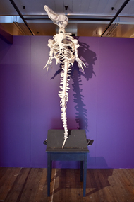
Sculpture - The Wreck of Hope, Michele Beevors, 2014
The Wreck of Hope (Long-nosed Common Dolphin skeleton, Delphinus delphis) featured as part of the exhibition Anatomy Lessons, shown at the National Wool Museum in 2024. The exhibition featured meticulously-sculpted, life size skeletons, making visitors question their place in this web of the living and the dead. From a towering giraffe stretching 4.4 metres in height, to an army of over 50 delicately rendered frogs, this exhibition was enthralling in scale. Each sculpture is an accurate portrayal of a real animal and is carefully measured, drawn, and moulded from steel, wire, and foam. The frame is then intricately knitted over to create these thought-provoking pieces. Each sculpture tells a story, one of the collection of animals by museums and collectors, of Western safari hunters, of human encroachment, and of the often-sad role of the animals in our lives. These underlying concepts are explored and reflected by the materials used. Wool, that speaks of warmth, of comfort, of care, meets the size, grace, and sheer breathtaking beauty of the pieces, clashing with the hard and complex stories beneath. This knitted dolphin skeleton was the start of Beevor's interest in comparative anatomy. Beevors recalls viewing a dolphin, one of many skeletons alongside a mouse and a lion in the Australian Museum's collection during a school visit in the 1970s. At the time, school children watched TV reruns of 'Flipper', which portrayed dolphins as intelligent and noble animals. Elsewhere, the conservation movement was growing, and appeals to protect marine mammals were gaining momentum through the 'Save the Whales' campaign. The fascination with live dolphin shows had grown throughout the 1960s and 1970s and the ethics began to be questioned. Some believe they played an important role in raising public awareness of cetaceans and their welfare. Others argued the performances glorified the dominance of heroic trainers over the subordinate dolphin, and offered little education about the dolphins' natural characteristics nor prioritised their welfare. Many of these facilities are now closed and all dolphin species are protected by international accords aimed at conserving wild populations. Despite this dolphins are still at risk of swallowing plastic waste, mercury toxicity, toxoplasmosis, boat impacts and being bycatch in commercial fishing operations. Originally from Australia, Michele Beevors has been practicing in New Zealand for the last 20 years. She is Head of Sculpture at Dunedin School of Art, Otago Polytechnic, New Zealand’s oldest, and one of its most prestigious, art schools. Beevors has exhibited in galleries, museums, and exhibition spaces in across New Zealand, Australia and Vienna with art that is defiant, unconventional, and moving.Life sized knitted skeleton of a dolphin, with white wool and internal steel, foam and wire frame. The dolphin is mounted on a wooden base, made from a desk, with books placed under the desk lid. The books and desk are painted black.knitting, art, dolphin, conservation, sculpture, skeletons, anatomy lessons, michele beevors -
 Sunbury Family History and Heritage Society Inc.
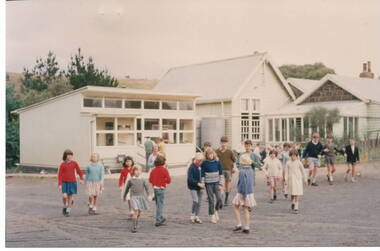
Photograph, Bulla Primary School, 1964
... . The modern portable classroom was added in the 1960s. Bulla Primary.... The modern portable classroom was added in the 1960s. Bulla Primary ...The school in the photograph is Bulla State School No. 46 and was originally known as the Government -funded Bulla Common School, built 1870 - 1871. With the passing of the Education Act in Victoria in 1873 it became known as Bulla State School No. 46. The original building comprised of a rectangular shaped bluestone building with a 3 roomed residence attached. As school enrolments began to increase in the district, a weatherboard classroom was added in 1881 and later extended in 1927 adjacent to the original building with a covered walkway between the two buildings. The modern portable classroom was added in the 1960s. Bulla Primary School closed in 1996 after much local controversy. The property is now privately owned. The photograph was taken in 1964.The bluestone section of the school with residence is one of very few remaining in the state and is of local heritage classification in the City of Hume.A non-digital coloured photograph of children in a school playground with the buildings visible in the background.bulla state school no. 46, school lane, bulla, education act 1873, common schools -
 Melbourne Tram Museum
Photograph - Digital Image, Kevin O'Reilly, "Kew Burke Rd' looking at the East Kew Tram terminus, c1925
Image from CD (Compact Diskette for use in computers) - see Reg Item 135. Image titled "Kew Burke Rd' on CD, of looking at the East Kew Tram terminus with the city skyline in the background, c1925. Photo published in the Bellcord No. 16, Oct. 2012. From the article with the photograph; The terminus was located at the intersection of High St, Burke, Kilby and Doncaster Roads. We are at the outer edges of Melbourne’s suburbia at the time, unlike the current tram terminus of today. Burke Road, north of Doncaster Road is clearly under construction in preparation for the new river crossing. The vacant block of land in the foreground will remain so for another ten years or so. In 1960 the new Dickens Supermarket was built on this site and the intersection became known locally as Dickens Corner. The narrow track on the left hand side of the photo is Doncaster Road. The tram at the terminus is a straight-sill single trucker of one of the G, K, Q or R classes. It is finished in the late MMTB chocolate and cream livery. A cable grip car body has been placed as a tram shelter at the terminus. The church was subsequently relocated to Francis Street Yarraville where it still stands today as a private residence. Behind the large hedge on the south side of High Street is Smith’s Dairy. Part of this land would be sold to the MMTB for a planned new tram depot Behind the large hedge on the south side of High Street is Smith’s Dairy. Part of this land would be sold to the MMTB for a planned new tram depot but by the early 1960s it was transferred to the Education Department for construction of the Kew High School. The last portion of the dairy closed in the 1970s.trams, tramways, kew, burke rd, east kew, doncaster rd -
 Kew Historical Society Inc
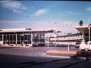
Photograph - California Motel, Barkers Road, Ron Setford, 1961
Ron Setford and his wife Grace Setford lived in Tanner Avenue, East Kew, from c.1946 to c.1995. A keen photographer, he recorded the changing face of Kew over a 20 year period. Apart from 30 photographs of built structures and places in Kew dating from 1960 and 1961, 145 of his 35mm colour slides chronicle the development of the Eastern Freeway through the Yarra Valley over a five year period from c.1972 to c.1977. This important collection was donated to the Society by his granddaughter in 2025.This collection of 175 35mm slides is of local and statewide significance, owing to its subject matter, particularly the major development of road transport infrastructure during the 1970s with the construction of the Eastern Freeway. The photographer also took care to annotate and date most of his slides which enable the researcher to pinpoint temporal and spatial locations.Opened in 1960, the California Motel at 138 Barkers Road, Hawthorn, was located opposite the entrance to Xavier College and built on the site of the former Barker railway station of the closed Kew branch line. The motel was advertised as “away from the hustle and bustle of the city and offering affordable accommodation for the business or leisure traveller”. Special amenities included air-conditioning, a business centre, and swimming pool. The motel had 82 suites. A possibly forgotten, but perhaps essential feature of the motel, was the Caltex Service Station at its entrance. The building was closed in April 2008, extensively vandalised and finally demolished in 2013."California Motel"ron setford, photographs -- kew (vic.) -- 1960s, california motel -- barkers road -- hawthorn (vic.) -
 Kew Historical Society Inc
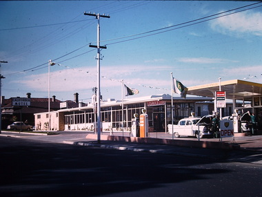
Photograph - California Motel, Barkers Road, Kew, Ron Setford, 1961
Ron Setford and his wife Grace Setford lived in Tanner Avenue, East Kew, from c.1946 to c.1995. A keen photographer, he recorded the changing face of Kew over a 20 year period. Apart from 30 photographs of built structures and places in Kew dating from 1960 and 1961, 145 of his 35mm colour slides chronicle the development of the Eastern Freeway through the Yarra Valley over a five year period from c.1972 to c.1977. This important collection was donated to the Society by his granddaughter in 2025.This collection of 175 35mm slides is of local and statewide significance, owing to its subject matter, particularly the major development of road transport infrastructure during the 1970s with the construction of the Eastern Freeway. The photographer also took care to annotate and date most of his slides which enable the researcher to pinpoint temporal and spatial locations.Opened in 1960, the California Motel at 138 Barkers Road, Hawthorn, was located opposite the entrance to Xavier College and built on the site of the former Barker railway station of the closed Kew branch line. The motel was advertised as “away from the hustle and bustle of the city and offering affordable accommodation for the business or leisure traveller”. Special amenities included air-conditioning, a business centre, and swimming pool. The motel had 82 suites. A possibly forgotten, but perhaps essential feature of the motel, was the Caltex Service Station at its entrance. The building was closed in April 2008, extensively vandalised and finally demolished in 2013.Nilron setford, photographs -- kew (vic.) -- 1960s, california hotel -- barkers road -- hawthorn (vic.), california motel -- barkers road -
 City of Kingston
Photograph - Colour, Circa 1993
Edithvale is a suburb in the City of Kingston. It is located between Aspendale and Chelsea on the Port Phillip Bay and built within remnant areas of the Carrum Carrum swamp. The foreshore precinct comprises a wide sandy beach, with low sand dunes and numerous historic boat sheds. The suburb consists of older style dwellings and former holiday houses, combined with mid-century housing and newer homes. The large blocks are increasingly subdivided and the existing dwellings demolished to accommodate units and townhouses, thus changing the landscape of the area and reducing the tree canopy.The beachside suburb of Edithvale was previously part of the extensive Carrum Carrum Swamp. The area was once a source of fish and eels for the Mayone-Bulluk clan of the Bunurong people. Over time the area was drained and predominantly devoted to dairy farming and holiday houses. The farms were gradually sold and subdivided with a large number of homes built after World War II and in the 1960s. Edithvale is mainly residential with a shopping strip along Nepean Highway but little significant industry was ever established in the area apart from a plaster works and confectionary factory, both now closed.Aerial colour photograph of Edithvale as viewed from Alexandra Avenue in the north to Ella Grove Chelsea/Edithvale in the south. The area is built-up with residential housing and facilities including Edithvale Primary School, numerous churches and the Edithvale Railway station. Large sections depict the remnant Carrum Carrum swamp. Edithvale Common and the former "Duck Inn" (Melbourne Water/Friends of Edithvale Seaford Wetlands) can be seen. Edithvale Recreational reserve, the velodrome and Edithvale Public Golf Course are prominent. The image shows vacant land in the area now known as Aspendale Gardens and the newer residential section of Chelsea Heights is not developed. A bike path has been established to cover the secondary drain. The Golf Links Court residential development located off Hughes Avenue is a large vacant block.Yellow circular adhesive sticker on plastic Black ink (marker): * (asterisk) Black type on white adhesive sticker: P000108edithvale, aspendale, chelsea, carrum carrum swamp -
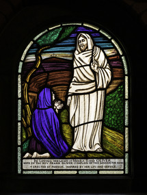 Mission to Seafarers Victoria
Artwork, other - Stained glass window, Joseph Stansfield, Noli Me Tangere - In memory of Moira Bird Oliver, 1969
Moira Bird Oliver (nee Good) was a the wife of Padre Frank Leslie Oliver. They lived in the Mission for about 30 years. From Bronwyn Hughes: "The subject shows the resurrected Christ appearing to Mary. The window was probably the work of Joseph Stansfield and Phoenix Studios. After Brooks, Robinson & Co. closed its stained glass department in the 1960s, Stansfield, who was the senior artist and head of the department, set up in business with the foreman of the leadlight department, Jim Lynch. Phoenix continued to provide stained glass windows to churches in Victoria, Tasmania and New South Wales."Arched windows depicting a woman kneeling in front of JesusIn Living Memory Of Moira Bird Oliver / Wife of Rev. Frank Leslie Oliver . Chaplain of this Mission for 30 Years / - Erected by Friends . Inspired by her Life and Service.st peter chapel, flinders street, mission to seafarers, seamen's mission, mission to seamen, st peter, sailors, seamen, stained glass windows, win, memorial chapel, hlg, harbour lights guild, moira bird oliver (nee good), joseph stansfield, phoenix studios