Showing 19401 items
matching coasts
-
 Flagstaff Hill Maritime Museum and Village
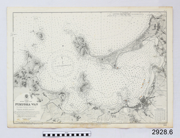
Document - Navigation Chart, Japan, Fukuoka Wan - Kyushu - North Coast
British Admiralty Navigation Chart - Japan, Fukuoka Wan - Kyushu - North Coastwarrnambool, shipwrecked-coast, flagstaff-hill, flagstaff-hill-maritime-museum, maritime-museum, shipwreck-coast, flagstaff-hill-maritime-village, shipwrecked-artefact, british admiralty, navigation chart -
 Flagstaff Hill Maritime Museum and Village
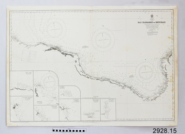
Document - Navigation Chart, Ras Makhabez to Bengazi
British Admiralty Navigation Chart - Africa, North Coast - Ras Makhabez to Bengaziwarrnambool, shipwrecked-coast, flagstaff-hill, flagstaff-hill-maritime-museum, maritime-museum, shipwreck-coast, flagstaff-hill-maritime-village, shipwrecked-artefact, ras makhabez to bengazi, british admiralty navigation chart, navigation chart -
 Flagstaff Hill Maritime Museum and Village
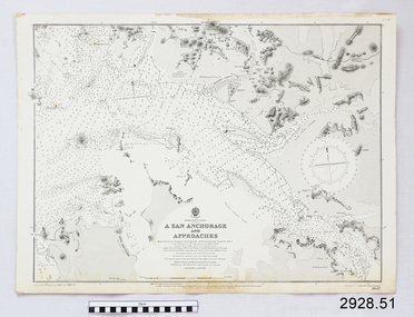
Document - Navigation Chart, A San Anchorage and Approaches
British Admiralty Navigation Chart - Korea - West Coast - A San Anchorage and Approacheswarrnambool, shipwrecked-coast, flagstaff-hill, flagstaff-hill-maritime-museum, maritime-museum, shipwreck-coast, flagstaff-hill-maritime-village, shipwrecked-artefact, navigation chart, british admiralty navigation chart, british admiralty, a san anchorage and approaches -
 Phillip Island and District Historical Society Inc.
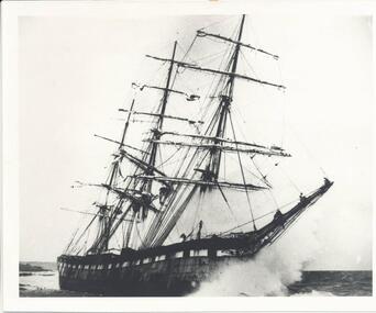
Photograph, The Speke, 22/02/1906
The Speke was an all steel ship of 310 feet, beam of 35 feet and weight of 2,712 tons and triple masted. She was built in 1891 at Carnarvon in Wales for a cost of 22,000 pounds. The wreck of the Speke was purchased for a mere 12 pounds after it went aground in 1906. The Speke had come from Peru to Sydney. She was then on her way to load wheat in Geelong when she ran aground on the 22 February 1906. Captain Tiltson confused a bushfire, near Cowes, for navigation lights. The ship drifted close to shore in Kitty Miller Bay and was eventually holed at 3 pm on the rocks. Life boats were immediately lowered and the ship’s crew all made it to shore except Seaman Frank Henderson, who lost his life.Black & White photograph of The Speke running aground on the south coast of Phillip Island.wreck of the speke, the speke, jack loney -
 National Vietnam Veterans Museum (NVVM)
Photograph, South Vietnamese Coastal patrol - 1969
Photograph of South Vietnamese Gun boat off the coast. there is a beach and hills in the backgroundMy Vietnam Collection. copyright Norm Cooperphotograph, gunboat, coastal patrol -
 Lakes Entrance Historical Society
Book, Fletcher Meredith, Squires Debra, Barraclough Linda, Gippsland Heritage Journal Vol 1 No. 1, 1986
Early discovery of Bass Straight and Gippsland coast and social history of Gippsland Victoriaexplorers, township, bibliography -
 Flagstaff Hill Maritime Museum and Village
Document - Navigation Chart, Admiralty Office, Lady Bay and Warrnambool Harbour, 03/04/1871
This Chart titled “Lady Bay and Warrnambool Harbour” was surveyed by Nav. Lieut. H.J. Stanley, of Britain's Royal Navy, in 1870 and printed in April 1871. The chart was made before the Warrnambool Breakwater was built (construction had begun in 1874 and was completed in 1890). The chart includes Directions for entering Lady Bay, Warrnambool Harbour. These are "Vessels entering Warrnambool Harbour must bring the Red Light in sight and steer in with it in line with the upper white Light bearing North, until the Green Light on the Jetty is opened, when steer towards it and anchor. The best anchorage is in 2 ¼ fms [fathoms)] of water, about a cable from ledge off Breakwater rock. Or where convenient, according to draught of water, only endeavouring to anchor as close as possible to Breakwater rock. It is not safe to enter or leave the Harbour in south westerly or Southerly gales.” This chart is significant for its strong connection to the maritime history of Warrnambool Harbour and Lady Bay, and eventually to the Warrnambool Breakwater. The Warrnambool Breakwater is registered as a place of significance on the Victorian Heritage Database (VHR H2024). A copy of the same chart was used to plan several submissions for future changes to the jetty and breakwater. The chart is a historical record of structures existing in 1870; the Warrnambool Jetties, Lady Bay, the leading lights (lighthouses), streets, roads, bridges and many buildings. It also shows the lay of the land and seabed.Canvas chart of Australia, South Coast, Victoria Title: Lady Bay and Warrnambool Harbour Surveyed by Nav. Lieut. H.J. Stanley, R.N., 1870. Magnet Variation, 1870 Published April 3, 1871, by the Admiralty, London. Directions for vessels entering Warrnambool Harbour are printed on the chart. The chart has a lacquer or seal over it.Top of chart has logo "HYDROGRAPHER OFFICE" "Price Eighteen Pence". "Engraved by Edward Weller" Along bottom of Chart: “London… Published at the Admiralty, 3rd April 1871, under the Superintendence of Rear Admiral G.H. Richards, F.R.S. Hydrographer, Corrections July 71” Bottom of chart “Australia South Coast Victoria Lady Bay and Warrnambool Harbour. 2494”flagstaff hill, warrnambool, chart of lady bay warrnambool 1870, warrnambool harbour, cartography, navigation, warrnambool breakwater, 1871, australia – south coast / victoria, lady bay, 1870, nav. lieut. h.j. stanley, r.n, directions for entering warrnambool harbour, hydrographer office, rear admiral g.h. richards, edward weller, port of warrnambool, flagstaff hill maritime museum & village, maritime museum, maritime village, shipwreck coast, map, chart, navigation chart, admiralty chart, breakwater, jetty, pier, vhr h2024 -
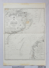 Flagstaff Hill Maritime Museum and Village
Document - Navigation Chart, Dungeness to the Thames and the Dover Strait
British Admiralty Navigation Chart - England - South Coast - Dungeness to the Thames and the Dover Straitwarrnambool, shipwrecked-coast, flagstaff-hill, flagstaff-hill-maritime-museum, maritime-museum, shipwreck-coast, flagstaff-hill-maritime-village, shipwrecked-artefact, navigation chart, british admiralty navigation chart, british admiralty, dungeness to the thames, dover strait -
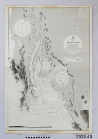 Flagstaff Hill Maritime Museum and Village
Document - Navigation Chart, Tavoy River
British Admiralty Navigation Chart - Bay of Bexgal - East Coast - Bruma - Tavoy Riverwarrnambool, shipwrecked-coast, flagstaff-hill, flagstaff-hill-maritime-museum, maritime-museum, shipwreck-coast, flagstaff-hill-maritime-village, shipwrecked-artefact, navigation chart, british admiralty navigation chart, british admiralty, tavoy river, bay of bexgal, bruma -
Glenelg Shire Council Cultural Collection
Poster - Poster - Admella 150 Festival, c. 2009
Laminaterd A3 poster promoting Admella 150 festival events in the limestone coast and Discovery coast regions. Posters shades of blue with black and white printing. Admella 150 logo top left corner. Gold sponsors logo's top right. -
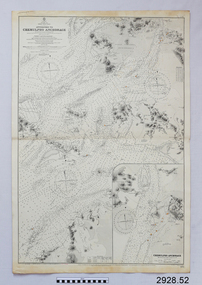 Flagstaff Hill Maritime Museum and Village
Document - Navigation Chart, Approaches to Chemulpho Anchorage
British Admiralty Navigation Chart - Yellow Sea - Korea East Coast - Approaches to Chemulpho Anchoragewarrnambool, shipwrecked-coast, flagstaff-hill, flagstaff-hill-maritime-museum, maritime-museum, shipwreck-coast, flagstaff-hill-maritime-village, shipwrecked-artefact, navigation chart, british admiralty navigation chart, british admiralty, approaches to chemulpho anchorage, korea -
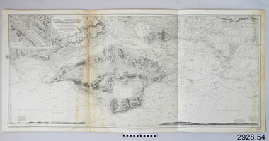 Flagstaff Hill Maritime Museum and Village
Document - Navigation Chart, Owers to Christchurch with Spithead and the Isle of Wight
British Admiralty Navigation Chart - England - South Coast - Owers to Christchurch with Spithead and the Isle of Wightwarrnambool, shipwrecked-coast, flagstaff-hill, flagstaff-hill-maritime-museum, maritime-museum, shipwreck-coast, flagstaff-hill-maritime-village, shipwrecked-artefact, navigation chart, british admiralty navigation chart, british admiralty, owers to christchurch -
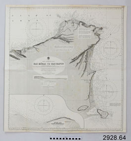 Flagstaff Hill Maritime Museum and Village
Document - Navigation Chart, Africa - North East Coast - Ras Kòrai to Ras Hafun
British Admiralty Navigation Chart - Africa - North East Coast - Ras Kòrai to Ras Hafunwarrnambool, shipwrecked-coast, flagstaff-hill, flagstaff-hill-maritime-museum, maritime-museum, shipwreck-coast, flagstaff-hill-maritime-village, shipwrecked-artefact, navigation chart, british admiralty navigation chart, british admiralty, ras kòrai to ras hafun, gulf of aden, africa : north east coast -
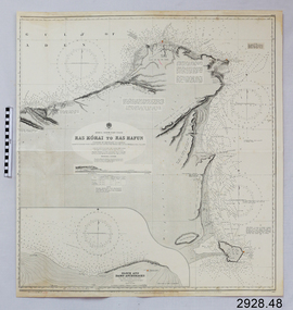 Flagstaff Hill Maritime Museum and Village
Document - Navigation Chart, Africa - North East Coast - Ras Kòrai to Ras Hafun
British Admiralty Navigation Chart - Africa - North East Coast - Ras Kòrai to Ras Hafunwarrnambool, shipwrecked-coast, flagstaff-hill, flagstaff-hill-maritime-museum, maritime-museum, shipwreck-coast, flagstaff-hill-maritime-village, shipwrecked-artefact, navigation chart, british admiralty navigation chart, british admiralty, ras kòrai to ras hafun -
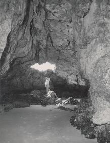 Phillip Island and District Historical Society Inc.
Photograph, Bryant West
One of a collection of over 400 photographs in an album commenced in 1960 and presented to the Phillip Island & Westernport Historical Society by the Shire of Phillip IslandPhotograph inside Forrest Caves South Coast Phillip Island. Man inside looking out. local history, photography, photographs, coastline, caves, phillip island, forrest caves phillip island, john jenner, bryant west -
Glenelg Shire Council Cultural Collection
Souvenir - Keyring - Portland Coast Region Water Authority, n.d
Key ring - Portland Coast Region Water Authority, gold coloured metal, enamelled designsouvenir, advertising -
Glenelg Shire Council Cultural Collection
Accessory - Badge - Bridgewater Sports, n.d
Metal badge, Bridgewater Sports New Year's Day with image of Cape Bridgewater and coast; roundcelebration, new years day, badge, cape bridgewater -
 Bendigo Historical Society Inc.
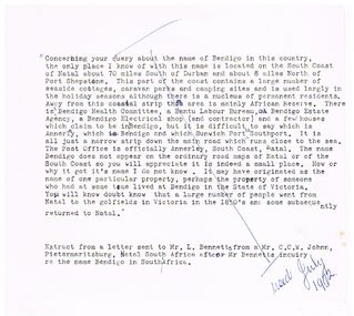
Document - BENDIGO - NATAL, 07/1972
Typed notes about a query about the name of Bendigo on the South Coast of Natal, South Africa.document, bendigo - natal, mr l bennetts, mr c c w johnn -
 Queenscliffe Maritime Museum
Newsletter - Essay by J McGrath "Some famous clippers"", Typed essay by J McGrath about American built clippers trading around Australia's coast, unknown date of production
Trading clipper shipsAustralian coastal tradeTyped essay by J McGrath about American built clippers trading around Australia's coast.Reverse - " NIL ".historical references -
 Queenscliffe Maritime Museum
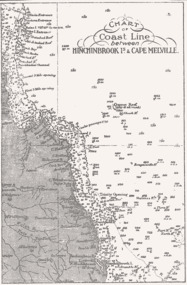
Map - B & W coastal map of Hinchinbrook Island to Cape Melville in Queensland, Coastal map Queensland Hinchinbrook Is to Cape Melville, Before donation in 1987
Australian coastal mapsAustralian coastal mapsMap from unknown book of Queensland coast Hinchinbrook Island to Cape Melville, pre 1987Reverse " NIL "old maps of australian coast -
 Kew Historical Society Inc
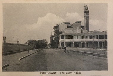
Postcard, The Cairo Postcard Trust, Port-Said - The Lighthouse, c.1918
One of a number of 'real photo' and commercial postcards created by or owned by members of the Christian and Washfold families of Kew. The postcards are part of a larger collection of photographs, postcards and publications donated to the collection in May 2021.Sepia postcard of Lighthouse at Port Said, located on the north east coast of Egypt on the Mediterranean Sea.The Cairo Postcard Trust Cairo 957 / Serle 632washfold family, postcards -- port said, christian family, christian-washfold collection -
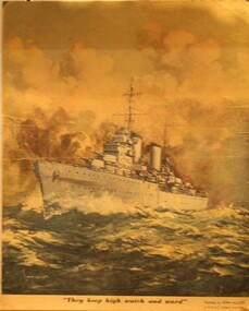 Ringwood RSL Sub-Branch
Printed Display item, Circa WW2
Coloured print of the HMAS Sydney which was lost with all hands of the Western Australian Coast in WW2"They keep high watch and ward" The HMAS Sydney in action by John Allcot. -
Lakes Entrance Historical Society
Booklet, Ronald Parsons, Australian Coastal Passenger Ships, 1981
The details and a brief outline of the career of every steam and motor ship that carried passengers on the Australian coast.ships and shipping -
Tatura Irrigation & Wartime Camps Museum
Photograph, 2001
Jack Sharpley lived in Erica Av. Tatura. His father was a P.M.G. Linesman c.1939. Jack attended Tatura Convent & Shepparton High School. Joined staff of State Savings Bank, and attended Melbourne University. Entered Air Force in Air Training Corps 1941. Trained in Canada as a Flight Observer. Posted to a Sunderland Flying Boat Squadron in England. Killed 04.02.1943 in a flying accident off the coast of Wales. A brillian pupil and an outstanding athlete.Photograph of Jack Sharpley who lived in Erica Av. Tatura. His father was on the P.M.G. line staff at Tatura c.1939-41. Jack entered the RAAF through the Air Training Corps. Trained in Canada, flew in Sunderland Flying Boats. Died in crash on duty off the coast of Wales.sharpley, jack, raaf, photograph, people -
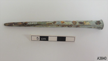 Flagstaff Hill Maritime Museum and Village
Functional object - Nail
This historic bronze nail dates back to 1790s to 1890s. Nails such as this one were used for ship building, as deck fasteners and many other uses. This nail was made at a time when the shanks of nails were usually machine cut but the heads were hand formed by blacksmiths. The nail was recovered from a shipwreck along the coast of Victoria in around 1968 and is part of the John Chance Collection. The nail is significant historically as an example of hardware used when building wooden ships in the early to mid-19th century. The nail is historically significant as an example of the work and trade of blacksmith. The nail is also significant as it was recovered by John Chance, a diver in Victoria’s coastal waters in the late 1960s to early 1970s. Items that come from several wrecks have since been donated to the Flagstaff Hill Maritime Village’s museum collection by his family, illustrating this item’s level of historical value.Nail; bronze, deck nail. Rounded rectangular head, rectangular shank cross-section, tip flattened to a rounded wedge shape. The surface is pitted and rough and has blue-grey, green and orange concretion and degradation on the nail's surface. Recovered from an unspecified shipwreck along the coast of Victoria. Part of the John Chance Collection. flagstaff hill, warrnambool, flagstaff hill maritime museum, maritime museum, shipwreck coast, flagstaff hill maritime village, great ocean road, john chance, fastener, nail, square nail, machine cut mail, blacksmith, historic nail, bronze nail, hand forged, coastal shipwreck, victorian shipwreck -
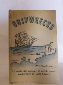 Flagstaff Hill Maritime Museum and Village
Book, Shipwrecks
Margaret MacKenzie had first hand knowledge of many shipwrecks along Victoria's treacherous 'shipwreck' coast. In her later years her failing sight caused her to attend the nearby eye specialist Dr W.R. Angus in Warrnambool. Dr Angus designed the cover for Margate's book. Margaret's daughter assisted in the writing due to her mother's failing sight.Shipwrecks by M.E. MacKenzie, part of the W.R. Angus Collection. An authentic account of wrecks from Peterborough to Cape Otway, Victoria. Cover printed in blue, black and white, depicts sailing ship approaching cliffs, and a map of the coast of south west Victoria, showing Peterborough and Cape Otway. Art work for cover was done by Dr. W.R. Angusflagstaff hill, warrnambool, shipwrecked-coast, flagstaff-hill, flagstaff-hill-maritime-museum, maritime-museum, shipwreck-coast, flagstaff-hill-maritime-village, shipwrecks, m e mackenzie, peterborough, cape otway, shipwreck coast, book, w.r. angus -
 Phillip Island and District Historical Society Inc.
Photograph - Post Card, 1920's
One of a collection of photographs donated by Steve Stefan, Archivist, St Frances Church, MelbourneBlack & White postcard showing the rugged coastline at San Remo."The Rose Series, P. 710" "The picturesque coast, San Remo, Victoria"san remo coastline, coastline, steve stefan -
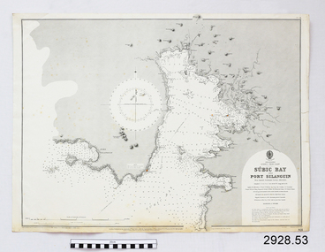 Flagstaff Hill Maritime Museum and Village
Document - Navigation Chart, Sùbic Bay and Port Silanguin
British Admiralty Navigation Chart - Phillipines - Luzom I. - West Coast - Sùbic Bay and Port Silanguinwarrnambool, shipwrecked-coast, flagstaff-hill, flagstaff-hill-maritime-museum, maritime-museum, shipwreck-coast, flagstaff-hill-maritime-village, shipwrecked-artefact, navigation chart, british admiralty navigation chart, british admiralty, phillipines, sùbic bay and port silanguin -
 Flagstaff Hill Maritime Museum and Village
Document - Navigation Chart, Chinnampo Ko, Pingyang Inlet : Yellow Sea, West Coast of Korea
British Admiralty Navigation Chart, Chinnampo Ko, Pingyang Inlet : Yellow Sea, West Coast of Koreawarrnambool, shipwrecked-coast, flagstaff-hill, flagstaff-hill-maritime-museum, maritime-museum, shipwreck-coast, flagstaff-hill-maritime-village, shipwrecked-artefact, navigation chart, british admiralty navigation chart, british admiralty, pingyang inlet, chinnampo ko -
Glenelg Shire Council Cultural Collection
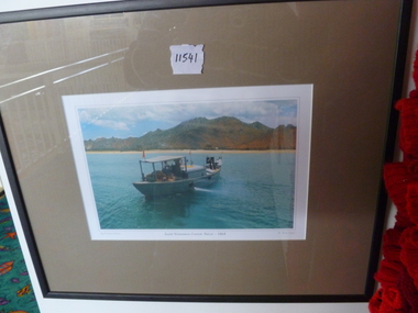
Photograph - Photograph - Tohoku Paper Co., Ltd., Akita Mill, n.d
Glenelg Shire Council RecordsAerial view of a factory on the coast. Jetties and piers in background. Framed in aluminium frame with thin plastic glazing.Front: Tohoku Paper Co., Ltd, Akita Millpaper and pulp industries, japan, maritime industry