Historical information
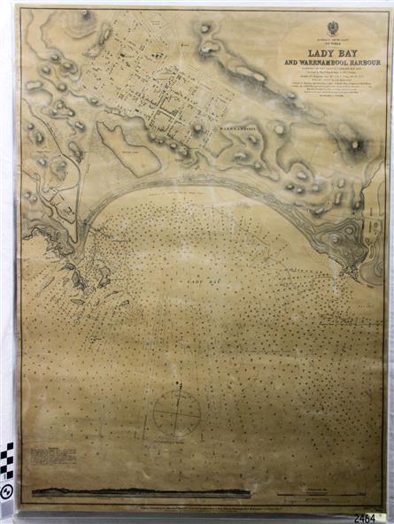
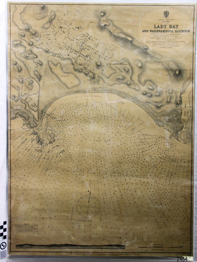
This Chart titled “Lady Bay and Warrnambool Harbour” was surveyed by Nav. Lieut. H.J. Stanley, of Britain's Royal Navy, in 1870 and printed in April 1871. The chart was made before the Warrnambool Breakwater was built (construction had begun in 1874 and was completed in 1890).
The chart includes Directions for entering Lady Bay, Warrnambool Harbour. These are
"Vessels entering Warrnambool Harbour must bring the Red Light in sight and steer in with it in line with the upper white Light bearing North, until the Green Light on the Jetty is opened, when steer towards it and anchor. The best anchorage is in 2 ¼ fms [fathoms)] of water, about a cable from ledge off Breakwater rock. Or where convenient, according to draught of water, only endeavouring to anchor as close as possible to Breakwater rock. It is not safe to enter or leave the Harbour in south westerly or Southerly gales.”
Significance
This chart is significant for its strong connection to the maritime history of Warrnambool Harbour and Lady Bay, and eventually to the Warrnambool Breakwater. The Warrnambool Breakwater is registered as a place of significance on the Victorian Heritage Database (VHR H2024). A copy of the same chart was used to plan several submissions for future changes to the jetty and breakwater.
The chart is a historical record of structures existing in 1870; the Warrnambool Jetties, Lady Bay, the leading lights (lighthouses), streets, roads, bridges and many buildings. It also shows the lay of the land and seabed.
Physical description
Canvas chart of Australia, South Coast, Victoria
Title: Lady Bay and Warrnambool Harbour
Surveyed by Nav. Lieut. H.J. Stanley, R.N., 1870. Magnet Variation, 1870
Published April 3, 1871, by the Admiralty, London.
Directions for vessels entering Warrnambool Harbour are printed on the chart.
The chart has a lacquer or seal over it.
Inscriptions & markings
Top of chart has logo "HYDROGRAPHER OFFICE"
"Price Eighteen Pence". "Engraved by Edward Weller"
Along bottom of Chart: “London… Published at the Admiralty, 3rd April 1871, under the Superintendence of Rear Admiral G.H. Richards, F.R.S. Hydrographer, Corrections July 71”
Bottom of chart “Australia South Coast Victoria Lady Bay and Warrnambool Harbour. 2494”
Subjects
- flagstaff hill,
- warrnambool,
- chart of lady bay warrnambool 1870,
- warrnambool harbour,
- cartography,
- navigation,
- warrnambool breakwater,
- 1871,
- australia – south coast / victoria,
- lady bay,
- 1870,
- nav. lieut. h.j. stanley,
- r.n,
- directions for entering warrnambool harbour,
- hydrographer office,
- rear admiral g.h. richards,
- edward weller,
- port of warrnambool,
- flagstaff hill maritime museum & village,
- maritime museum,
- maritime village,
- shipwreck coast,
- map,
- chart,
- navigation chart,
- admiralty chart,
- breakwater,
- jetty,
- pier,
- vhr h2024
References
- VHD Warrnambool Breakwater, Viaduct and Harbour Victorian Heritage Database
- Warrnambool City Council – Warrnambool Breakwater