Showing 123 items matching "computer paper"
-
![Map, [Coornmill land area available for leasing for grazing, Parish of Coornmill]. Circa 1904](/media/collectors/5e461d8021ea67224c82f2a1/items/677cde147f2053f3e5d277c3/item-media/677cdeea7f2053f3e5d27bb4/item-fit-380x285.jpg) Bacchus Marsh & District Historical Society
Bacchus Marsh & District Historical SocietyMap, [Coornmill land area available for leasing for grazing, Parish of Coornmill]. Circa 1904
This map shows an area of land north of Bacchus Marsh in the Larderderg State Park area known as the Parish of Coornmill.The map indicates an area of land which was to be made available by public tender for grazing leaseholders. The plan to do this was discussed in the Bacchus Marsh Express newspaper on the 16 July, 1904, page 2, column 7. The area reserved for grazing leases is identified by red lines on the map. The Express described the area available for grazing was 12,000 acres.A single page paper map showing an area of land in the Parish of Corrnmill to be made available for grazing leases. A photo lithographed Lands Department Map. No scale indicated. The map is pasted into a bound volume containing 76 maps or plans in total. High resolution digital image stored on BMDHS computer network. coornmill parish maps, lerderderg state park maps, agriculture bacchus marsh area -
 Bacchus Marsh & District Historical Society
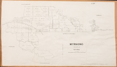
Map, Village allotments, Parish of Myrniong, County of Bourke
Myrniong is a village 9 kilometers west of Bacchus Marsh. Prior to 1863 the area was known as Blow's Flat. This map which was produced in 1903 and according to the catalogue record of this map held at the State Library of Victoria was based on an earlier map created in 1861. The early layout of streets for the village of Myrniong can be seen on this map. The streets shown are, Main Street, Hardy Street, Blow Street, Myrniong Street, Shuter Street, and Blackwood Street. An area marked as a reserve for a school can be seen between Hardy Street and Main Street.A single page paper map. A cadastral parish map of Myrniong in Victoria, showing numbered land allotments. Photo-lithographed at the Department of Lands & Survey, Melbourne, in 1903. Based on an original map created in 1861. The map is pasted into a bound volume containing 76 maps or plans in total. High resolution digital image stored on BMDHS computer network. Surveyed by John Hardy, Surveyor ; photo-lithographed at the Department of Lands & Survey, Melbourne by T.F. McGauran, 24.12.03myrniong parish plan, myrniong parish maps -
 Bacchus Marsh & District Historical Society
Map, Myrniong Parish Map 1904
A single page paper map showing the map for the Parish of Myrniong in the County of Bourke. A cadastral map showing parish boundaries and land ownership. The map is pasted into a bound volume containing 76 maps or plans in total. High resolution digital image stored on BMDHS computer network. myrniong parish plan, myrniong parish maps, bacchus marsh region parish plans -
 Bacchus Marsh & District Historical Society
Map, Parwan Parish Map, County of Grant, 1909
A single page paper map showing the map for the Parish of Parwan in the County of Grant. A cadastral map showing parish boundaries and land ownership. The map is pasted into a bound volume containing 76 maps or plans in total. High resolution digital image stored on BMDHS computer network. Photo-lithographed at the Department of Lands and Survey, Melbourne by T.F. McGauran, 7.7.09. bacchus marsh region parish plans, parwan parish maps, parwan parish plan -
 Bacchus Marsh & District Historical Society
Map, Trentham Parish Map 1905 Copy 1
A single page paper map showing the map for the Parish of Trentham in the Counties of Dalhousie and Bourke. A cadastral map showing parish boundaries and land ownership. The map is pasted into a bound volume containing 76 maps or plans in total. High resolution digital image stored on BMDHS computer network. Photo-lithographed at the Department of Lands and Survey, Melbourne by T.F. McGauran 22.3.05 trentham parish maps, trentham parish plan, bacchus marsh region parish plans -
 Bacchus Marsh & District Historical Society
Map, Coimadai Parish Map, County of Bourke. Circa 1890s-1900s
The cadastral Parish of Coimadai, a subdivision of the County of Bourke, lies directly north of the township of Bacchus Marsh. The date of this map is uncertain. T.F. McGauran the person who made a photo-lithographic copy of the map was in charge of photo-lithography at the Victorian Department of Lands and Survey in the late 19th century until about 1910.A single page paper map showing the map for the Parish of Coimadai in the County of Bourke. A cadastral map showing parish boundaries and land ownership. A rectangle shaped area is missing from the centre of the map due to a tear or deliberate excision. The map is pasted into a bound volume containing 76 maps or plans in total. High resolution digital image stored on BMDHS computer network. Photo-lithographed at the Department of Lands and Survey, Melbourne by T.F. McGauran 26.8.[??] NOTE. Photo litho from L.P showing temporary surveys and occupation of land prepared for departmental use onlybacchus marsh region parish plans, coimadai parish maps, coimadai parish plan -
 Bacchus Marsh & District Historical Society
Map, Gorrockburkchap Parish Map, County of Grant c.1906
The parish of Gorrockburkchap (sometimes spelled Gorrockburkghap) lies to the west and south west of the township of Bacchus Marsh. The locality of Rowsley is situated within this parish area.A single page paper map showing the parish plan for Gorrockburkchap in the County of Grant. A cadastral map showing parish boundaries and land ownership The map is pasted into a bound volume containing 76 maps or plans in total. High resolution digital image stored on BMDHS computer network. gorrockburkchap parish maps, rowsley victoria maps, bacchus marsh region parish plans -
 Bacchus Marsh & District Historical Society
Map, Plan of Land at Bacchus Marsh, the Property of James Young, 1868
James Young was a prominent businessman, land owner and public figure in the early colonial period of Bacchus Marsh. In February 1868 he offered for sale through the agent W. Anderson 38 blocks of land which ran from the Lerderderg RIver westwards beyond Gisborne Road in the vicinity of the present day Masons Land. The land for sale was described as, 'unsurpassed Agricultural Land, in the immediate vicinity of Bacchus Marsh, varying in size from 2 to 12 acres each'. The sale notice in the Bacchus Marsh Express of 1st February 1868 page 2, also noted that, ' Plans can be seen at Mr. Young's Border Mills Store, and at the Border Inn'. One of the largest and most important land sales in the early colonial period of Bacchus Marsh.A single page paper map showing 38 blocks of land for sale in 1868 in the vicinity of Masons Lane Bacchus Marsh. Scale 11 chains to 1 inch. The map is pasted into a bound volume containing 76 maps or plans in total. High resolution digital image stored on BMDHS computer network. land sales bacchus marsh, bacchus marsh victoria maps, james young 1816-1871, masons lane bacchus marsh land sales -
 Bacchus Marsh & District Historical Society
Map, Blackwood Parish Map, County of Bourke, 1892
A single page paper map showing the map for the Parish of Blackwood in the County of Bourke. A cadastral map showing parish boundaries and land ownership. The map is pasted into a bound volume containing 76 maps or plans in total. High resolution digital image stored on BMDHS computer network. Photo-lithographed at the Department of Lands and Survey, Melbourne by T.F. McGauran 14.7.92bacchus marsh region parish plans, blackwood parish plan, blackwood parish maps -
 Bacchus Marsh & District Historical Society
Map, Blackwood Parish Map, County of Bourke, 1905
A single page paper map showing the map for the Parish of Blackwood in the County of Bourke. A cadastral map showing parish boundaries and land ownership. The map is pasted into a bound volume containing 76 maps or plans in total. High resolution digital image stored on BMDHS computer network. Photo-lithographed at the Department of Lands and Survey, Melbourne by T.F. McGauran 21.7.05bacchus marsh region parish plans, blackwood parish plan, blackwood parish maps -
![Map, Liquidator's sale, 1896. [Woolpack Estate, Bacchus Marsh]](/media/collectors/5e461d8021ea67224c82f2a1/items/6779ee97032b72846b5995f2/item-media/6779ef33032b72846b599b30/item-fit-380x285.jpg) Bacchus Marsh & District Historical Society
Bacchus Marsh & District Historical SocietyMap, Liquidator's sale, 1896. [Woolpack Estate, Bacchus Marsh]
The Woolpack Estate was an area of land owned by various landowners in the Bacchus Marsh area since the early Colonial period of the 1840s. The area was located on the eastern side of the Bacchus Marsh township about 7 kilometers from the town. The Lerderderg River ran through part of the land and so did the Melbourne to Ballarat Road. The historic Woolpack Inn associated with James Crook was also located on this land. By 1896 150 acres of this land was under the control of liquidators for the Federal Bank of Australasia who instructed that the land be sub-divided and sold in lots by public auction. A successful sale was held on 24 June 1896. Most of the blocks of land were sold for higher than expected prices and most of the buyers were people from the town and district of Bacchus Marsh. The map includes various details about the land which is described on the map as an "important sale of rich alluvial irrigable flat land in the Bacchus Marsh Valley, and other properties". The auction was conducted by the local agents W. Anderson and Bence in conjunction with Pearce Brothers also of Bacchus Marsh.A single page paper map showing a plan of 150 acres of land from the Woolpack Estate to be sold in various lots in June 1896. Also shown on the map are lots for sale at Robinson's Farm on Coimadai Creek and allotments near Bacchus Marsh railway station, including lots on Government Road (East Maddingley Road), View Street and Government Road (Parwan Road). No scale provided. The map is pasted into a bound volume containing 76 maps or plans in total. High resolution digital image stored on BMDHS computer network. land sales bacchus marsh, bacchus marsh victoria maps, woolpack estate bacchus marsh victoria -
 Bacchus Marsh & District Historical Society
Map, Myrniong Parish Map, County of Bourke, 1882
A single page paper map showing the map for the Parish of Myrniong in the County of Bourke. A cadastral map showing parish boundaries and land ownership. The map is pasted into a bound volume containing 76 maps or plans in total. High resolution digital image stored on BMDHS computer network. Photo-lithographed at the Department of Lands and Survey, Melbourne by J. Noone, 17.7.82myrniong parish plan, myrniong parish maps, bacchus marsh region parish plans -
 Bacchus Marsh & District Historical Society
Map, Bacchus Marsh Tuesday 23rd Oct. 1888, Lodge & Dunn's Paddocks 1888. Business and Mansion Sites
This map was created as a plan for an auction of land close to the Bacchus Marsh Railway Station. The auction took place on 23 October 1888. 102 allotments of land from an area known as Lodge and Dunn's paddocks was offered for sale. The auction was conducted by auctioneers based in Melbourne and was advertised in Melbourne newspapers as well as in the Bacchus Marsh Express newspaper. The auction plan contains a range of details including the selling agents, Munro and Baillieu; W.P. Lockhart; and John Turner, all of Melbourne, deposit terms for purchases, price of railway passes for a return trip from Melbourne to Bacchus Marsh of 1 shilling, and a description of the land as having 'magnificent views and perfect drainage'. A single page paper map showing allotments of land for sale along the Parwan Road in Maddingley. The map is pasted into a bound volume containing 76 maps or plans in total. High resolution digital image stored on BMDHS computer network. At bottom on left side: 'Harston & Co. Lith, Melb.'land sales bacchus marsh, land sales maddingley, bacchus marsh victoria maps, maddingley victoria maps -
 Bacchus Marsh & District Historical Society
Map, Bacchus Marsh Suburban Allotments Parwan Road Lodge & Dunn's Paddocks 1888
This map was created as a plan for an auction of land close to the Bacchus Marsh Railway Station. The auction took place on 23 October 1888. 102 allotments of land from an area known as Lodge and Dunn's paddocks was offered for sale. A single page paper map showing allotments of land for sale along the Parwan Road in Maddingley. The map is pasted into a bound volume containing 76 maps or plans in total. High resolution digital image stored on BMDHS computer network. land sales bacchus marsh, land sales maddingley, bacchus marsh victoria maps, maddingley victoria maps -
 Bacchus Marsh & District Historical Society
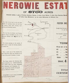
Map, Nerowie Estate Land Sale 1910
The Nerowie Estate was a large rural property of 8,700 acres (3520 hectares) near the locality of Parwan only a few kilometers east of Bacchus Marsh. It had once formed a large part of the land owned by the pioneering Staughton family.A single page paper map showing the land offered for sale from the Nerowie Estate at Parwan near Bacchus Marsh in 1910. The map is pasted into a bound volume containing 76 maps or plans in total. High resolution digital image stored on BMDHS computer network. nerowie estate parwan, land sales parwan, land sales bacchus marsh, staughton family bacchus marsh -
 Bacchus Marsh & District Historical Society
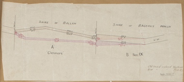
Map, Road plan deviation near Glenmore
This plan shows a proposed deviation in the road near Glenmore. This is likely to have been the Bacchus Marsh to Ballan road. The precise date of the plan has not been established. Proposed deviations to the road near Glenmore appear in reports in the Bacchus Marsh Express newspaper through many decades, especially in the 1870s and 1880s. Glenmore is located 19 kilometers west of Bacchus Marsh.A single page paper map showing a plan for a road deviation near Glenmore Station. Scale 5 chains to 1 inch. Date of production unknown. Circa 1860s-1890s. The map is pasted into a bound volume containing 76 maps or plans in total. High resolution digital image stored on BMDHS computer network. Old road colored Yellow, New road colored Pinkroad plans, road construction, glenmore victoria maps -
 Bacchus Marsh & District Historical Society
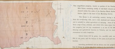
Map, Pentland Hills Estate Land Sale 1904
The Pentland Hills Estate property shown in this auction plan was put up for sale in 1904. It was a deceased estate sale. The property had been owned by Peter Grant who died in 1899. Peter Grant had worked and farmed in the Myrniong area for many years and had also been a Councillor on the Bacchus Marsh Shire for a number of terms. A property sales report in the Express newspaper recorded that the land for sale comprised 500 acres of the old Pentland Hills Estate. It was subdivided into three lots, all of which were sold at good prices. Lot l, 212 acres was sold to Messrs Thomas and Robert Lidgett of Myrniong, at £11/15/ per acre, lot 2, 200 acres, to Mr David Robertson, of Bacchus Marsh, at £9 17/0 per acre, and lot 3, 38 acres, was sold to Mr James Norton, jun at £11 per acre. A single page paper map showing a portions of land available for sale from the Pentland Hills Estate near Bacchus Marsh.The name of the seller, Mrs Grant, can seen handwritten on this map and the buyers of the three portions for sale, Lidgett lot 1, Robertson lot 2 and Morton lot 3. Parts of the text are missing along the edges due to tearing or excessive trimming of the edges. The map is pasted into a bound volume containing 76 maps or plans in total. High resolution digital image stored on BMDHS computer network. Handwritten: Mrs Grant, Myrniong, Executrix in the deceased Estate of Mr. Peter Grant to sell by public auction.land sales, pentland hills maps, myrniong area land sales, pentland hills estate -
 Bacchus Marsh & District Historical Society
Map, Plan of part of the road district of Bacchus Marsh circa 1856-1862
Local government in much of Victoria including the Bacchus Marsh area began with the formation of 'local committees'. These local committees could make representations to a Central Road Board regarding plans for road construction. Road construction and maintenance were seen as the essential tasks of these early local government authorities. By 1856 the local committee in Bacchus Marsh was constituted as the Bacchus Marsh Road District. This entity continued until 1862 when the name changed to the Bacchus Marsh and Maddingley Road District. This new entity lasted until 1871 when the local government authority in accordance with new statewide legislation became known as the Shire of Bacchus Marsh. The title of this plan being a plan of 'a portion of the road district of Bacchus Marsh' suggests that the plan was produced sometime between 1856 and 1862. The main purpose of this map was to shown the irrigable land in the district and the sources from which water for irrigation could be drawn. Bacchus Marsh was an early irrigation district in Victoria. Irrigation trusts were formed in the 1880s and 1890s to manage irrigation districts. But this was the culmination of many years of earlier attempts to construct irrigation systems in the Bacchus Marsh area and create a system to manage irrigation more broadly. This map dating from around 1856-1862 is an important cartographic document which provides evidence of how the early planning for irrigation was developing in the Bacchus Marsh region.A single page paper map showing a plan of part of the road district of Bacchus Marsh. The map is pasted into a bound volume containing 76 maps or plans in total. High resolution digital image stored on BMDHS computer network. bacchus marsh victoria maps, bacchus marsh road district, local government, road districts, irrigation -
 Bacchus Marsh & District Historical Society
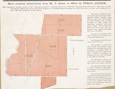
Map, Bullengarook Estate Property Sale. 1911
Bullengarook is a locality located 19 kilometers north of Bacchus Marsh. Pastoral leases for European colonists were granted to people for this area from around the 1840s.The Bullengarook Estate was part of these early pastoral holdings. By the 1900s the property had been owned by the Skene family for a number of years. In early 1911 the property then consisting of 300 acres and the homestead upon it was offered for sale in one lot. It appears however that the sale of the property did not go through in 1911. It was later leased by Thomas Skene to a Mr Coutts in 1915 and ultimately and at a later stage the property was sold by the Skene family.A single page paper map showing land allotments for sale from the Bullengarook Estate. The map is pasted into a bound volume containing 76 maps or plans in total. High resolution digital image stored on BMDHS computer network. land sales bacchus marsh, bullengarook land sales, bullengarook estate, bullengarook vic history -
![Map, Plan of Subdivision of Crown Portion 23 & parts 24-25, Parish of Korkuperrimul [1900s?]](/media/collectors/5e461d8021ea67224c82f2a1/items/675fe058304668462205d4fb/item-media/675fe0ef304668462205d7d6/item-fit-380x285.jpg) Bacchus Marsh & District Historical Society
Bacchus Marsh & District Historical SocietyMap, Plan of Subdivision of Crown Portion 23 & parts 24-25, Parish of Korkuperrimul [1900s?]
The Parish of Korkuperrimul includes a significant section of the township of Bacchus Marsh and extends in western and northern directions from the township area. The date of the subdivision indicated on this plan has not been established. The engineer's stamp on the drawing shows the firm of Muntz and Muntz who were operating under that name in the early part of the 20th century.A single page paper map showing 20 blocks of land for sale in the Parish of Korkuperrimul. Scale 100 feet to 1 inch. The map is pasted into a bound volume containing 76 maps or plans in total. High resolution digital image stored on BMDHS computer network. Stamped: 'Muntz & Muntz Civil Engineers, Architects & Surveyors, Trustees Chambers ?? Cor Collins Street and Bank Placeland sales bacchus marsh, bacchus marsh victoria maps, land sales korkuperrimul parish -
 Bacchus Marsh & District Historical Society
Map, Parish of Yangardook, County of Bourke 1876
The parish of Yangardook lies directly north of the township of Melton. The locality of Toolern Vale lies in the centre of this parish. A single page paper map showing the plan for the Parish of Yangardook in the in the County of Bourke. Scale 40 chains to 1 inch. The map is pasted into a bound volume containing 76 maps or plans in total. High resolution digital image stored on BMDHS computer network. Photo lithographed at the Department of Lands and Survey, Melbourne by J. Noone, 1.8.76yangardook parish maps, toolern vale victoria maps -
 Bacchus Marsh & District Historical Society
Map, Gaynor Street Area Land Sales, Maddingley, 1888
This map was produced for a major sale of land in the Maddingley area of Bacchus Marsh in 1888. The sale was conducted by two firms from Melbourne, Carney and Kelly 12 Swanston Street Melbourne. and 'Richardson, Kerr & Co. 40 Flinders Lane Melbourne. 136 blocks were for sale.A single page paper map showing land allotments for sale in the Maddingley area of Bacchus Marsh. Locations shown include Gaynor Street, Maddingley Road South, Parwan Road, Mitchem Street, Typpynge Street, Finn Street and East Maddingley Road. . The map is pasted into a bound volume containing 76 maps or plans in total. High resolution digital image stored on BMDHS computer network. bacchus marsh victoria maps, maddingley victoria maps, land use, maddingley victoria history, land sales bacchus marsh, land sales maddingley -
 Bacchus Marsh & District Historical Society
Map, Gaynor Street Land Sales, Maddingley, circa 1880s-1890s
This map was produced for a major sale of land in the Maddingley area of Bacchus Marsh. The precise date of the sale has not been determined. Features present on the map such as the Bacchus Marsh Railway Station indicate the land sale must have taken place some time after 1887 when the Railway Station opened. A single page paper map showing land allotments for sale in the Maddingley area of Bacchus Marsh. Locations shown include Gaynor Street, Maddingley Road South, Parwan Road, Mitchem Street, Typpynge Street, Finn Street and East Maddingley Road. . The map is pasted into a bound volume containing 76 maps or plans in total. High resolution digital image stored on BMDHS computer network. bacchus marsh victoria maps, maddingley victoria maps, land use, maddingley victoria history, land sales bacchus marsh, land sales maddingley -
 Federation University Art Collection
Work on paper - Bookplate, 'Ex Libris Bookplate for Zelma and John Gartner' by Wim Zwiers
The Keith Wingrove Trust conducts a competition among Australian artists, graphic designers and students for the production of Ex Libris Bookplates. The competition is called The Australian Bookplate Design Award. The purpose of the competition is to increase interest in and to attract publicity to the artistic value of bookplates. Although the competition is referred to as 'Australian' there is a category of award open to International artists. This bookplate was part of the 2013 Australian Bookplate Award. Wim Zwiers (b. 1922, Holland) Zwiers studied at the Academy of Fine Arts in Rotterdam from 1940 and graduated from there in 1944. Renowned as copper and wood engraver Zwiers became a teacher at an academy in Groningen. Zwiers has produced a few hundred bookplate. Around 1992 started to use the computer making ex-libris and other small graphics. Although he was not the first who started making computer exlibris, he surprised many by starting at age seventy. Framed etching - a bookplate for Zelma and John Gartner featuring a woman reading in the foreground and a weatherboard house in the background. Gift of the Keith Wingrove Memorial Trust, 2015Edition: 170/200 Signed: Wim Zwiersartist, artwork, printmaking, framed bookplate, available, bookplate, zweirs, zim zweirs, life drawing, keith wingrove memorial trust, australian bookplate design award, john gartner, zelma gartner -
 Federation University Art Collection
Work on paper - Artwork, Sammas Ex Libris
Framed bookplate - computer assisted designSigned lls 'Sammas-Illegible' lrs '1/3'bookplate, framed bookplate, keith wingrove bookplate design award, keith wingrove memorial trust -
 Bacchus Marsh & District Historical Society
Map, Gorrockburkchap Parish Map, County of Grant c.1915
The parish of Gorrockburkchap (sometimes spelled Gorrockburkghap) lies to the west and south west of the township of Bacchus Marsh. The locality of Rowsley is situated within this parish area.A single page paper map showing the parish plan for Gorrockburkchap in the County of Grant. The map is pasted into a bound volume containing 76 maps or plans in total. High resolution digital image stored on BMDHS computer network. gorrockburkchap parish maps, rowsley victoria maps -
 Bacchus Marsh & District Historical Society
Map, Gorrockburkchap Parish Map, County of Grant
The parish of Gorrockburkchap (sometimes spelled Gorrockburkghap) lies to the west and south west of the township of Bacchus Marsh. The locality of Rowsley is situated within this parish area.A single page paper map showing the parish plan for Gorrockburkchap in the County of Grant. The map is pasted into a bound volume containing 76 maps or plans in total. High resolution digital image stored on BMDHS computer network. gorrockburkchap parish maps, rowsley victoria maps -
 Bacchus Marsh & District Historical Society
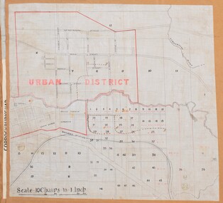
Map, Bacchus Marsh Urban District
The date of this map has not been established but the date would be sometime after 1887 as the Bacchus Marsh Railway Station, which opened in 1887, is shown on the map. A single page paper map showing blocks of land in the urban district of Bacchus Marsh. The 'urban district' is indicated by red drawn lines on the map and includes streets and blocks on the northern side of the Werribee River in Bacchus Marsh, and streets and blocks south of the Werribee in Maddingley. Scale 10 chains to 1 inch. The map is pasted into a bound volume containing 76 maps or plans in total. High resolution digital image stored on BMDHS computer network. bacchus marsh victoria maps, maddingley victoria maps -
 Bacchus Marsh & District Historical Society
Map, Balliang Parish Map, County of Grant c.1907
A single page paper map showing parish plan map for Balliang. This parish area contains the localities of Balliang and Balliang East and is located south of the township of Bacchus Marsh. The map is pasted into a bound volume containing 76 maps or plans in total. High resolution digital image stored on BMDHS computer network. balliang victoria maps, balliang parish maps -
 Bendigo Military Museum
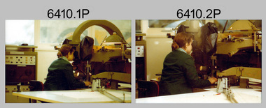
Photograph - Capturing Topographic Features with a Wild B8, AUTOMAP 1 Systems Operations – Army Survey Regiment, Fortuna, Bendigo, 1980
This is a set of 24 photographs of Air Survey Squadron technicians capturing topographic Features with a Wild B8 stereo plotter and operating AUTOMAP 1 equipment at the Army Survey Regiment at Fortuna, Bendigo, 1980. 17 of these photographs were taken of SPR Nick Van Dalen and SPR Santina (Argetto) Straube capturing topographic features – plotting with a Wild B8 stereo plotter were most likely taken in 1980. See item 6185.4P for black & white copies of photos of SPR Santina (Argetto) Straube operating the Wild B8 stereo plotter. Refer to item 6204.8P for detailed information and additional photographs of the Wild B8 stereo plotter. The history of the AUTOMAP 1 system is covered in more detail with additional historic photographs in pages 116-118 of Valerie Lovejoy’s book 'Mapmakers of Fortuna – A history of the Army Survey Regiment’ ISBN: 0-646-42120-4. See items 6122.20P, 6183.19P, 6184.20P, 6200.5P, and 6222.17P for additional photographs of the AUTOMAP 1 system.This is a set of 24 photographs of Air Survey Squadron technicians capturing topographic features with a Wild B8 stereo plotter and operating AUTOMAP 1 equipment at the Army Survey Regiment at Fortuna, Bendigo, c1980. The photographic proofs were printed on photographic paper and are part of the Army Survey Regiment’s Collection. The photographic proof prints were scanned at 600 dpi. .1) to .8) Photo, black & white, 1980. SPR Santina (Argetto) Straube operating a Wild B8 stereo plotter. .9) to .17) Photo, black & white, 1980. SPR Nick Van Dalen operating a Wild B8 stereo plotter. .18) to .24) Photo, black & white, 1980. CPL Gerry Gunn undertaking AUTOMAP 1 computer system duties..1P to .24P – no annotations.automap 1, royal australian survey corps, rasvy, army survey regiment, army svy regt, fortuna, asr, photogrammetry