Showing 1713 items
matching counties
-
 Stawell Historical Society Inc
Map, Illawarra, County of Borung, 1882
Illawarra, County of Borungstawell -
Stawell Historical Society Inc
Map, Illawarra, County of Borung, 1955
Illawarra, County of Borungstawell -
Stawell Historical Society Inc
Map, Kirkella, County of Borung, 1957
Kirkella, County of Borungstawell -
Stawell Historical Society Inc
Map, Moyston, County of Borung, 1951
Moyston, County of Borungstawell -
Stawell Historical Society Inc
Map, Jallukar, County of Borung, 1971
Jallukar, County of Borungstawell -
Stawell Historical Society Inc
Map, Stawell, County of Borung, 1959
Stawell, County of Borungstawell -
Stawell Historical Society Inc
Map, William, County of Borung, Shire of Stawell, 1945
William, County of Borungstawell -
Whitehorse Historical Society Inc.
Document, Certificate of Title, 1928, 1933-1934
Certificate of Title, Nanny Schifferdecker.Certificate of Title, Nanny Schifferdecker. Lots 44, 45,56 & 57 subdivision 3360 Crown portion 97 Parish of Nunawading, County of Bourke 1928. Vol 5406 fol 10881070 1928, Agnew and Craig Streets. Also correspondence re rates enforcement charge 1933.Certificate of Title, Nanny Schifferdecker. land titles, shire of blackburn and mitcham, schifferdecker, hanny, craig street, blackburn south, agnew street, blackburn south -
 Whitehorse Historical Society Inc.
Map - Parish Map, Parish of Nunawading, 1892
A map copied from 'Directory maps - parishes and counties' dated 26 Nov 1892. Compiled and lithographed by G.S. Bonney. The map includes roads, railway, stations, names of property owners. It has a scale [ca. 1:31,680] 40 chains to an 1 inch.A map copied from 'Directory maps - parishes and counties' dated 26 Nov 1892. Compiled and lithographed by G.S. Bonney. The map includes roads, railway, stations, names of property owners. It has a scale [ca. 1:31,680] 40 chains to an 1 inch.non-fictionA map copied from 'Directory maps - parishes and counties' dated 26 Nov 1892. Compiled and lithographed by G.S. Bonney. The map includes roads, railway, stations, names of property owners. It has a scale [ca. 1:31,680] 40 chains to an 1 inch.maps, parish of nunawading -
 Greensborough Historical Society
Map, Greensborough Map with Rail Line Plan, 1970s
Central Greensborough area, including railway line and some landowners. Basic map made c. 1902; annotations dated to circa 1970sTwo copies of planParish of Keelbundora, County of Bourke. Central Greensborough areagreensborough, greensborough railway station -
Port Melbourne Historical & Preservation Society
Map - County of Bourke, Thomas Bibbs, 1866
Map of the County of Bourke, 1886melbourne -
Stawell Historical Society Inc
Map, Department of Crown Lands and Survey Victoria, Allotments in the Township of Banyana. Parish of Burrum Burrum. 1946 / 1971, 1971
Richardson River. Avon River JunctionPaper Map of County of BorungReprint of the 1946 edition. Drawn and reproduced at the Department of Crown Lands and Survey Victoria 1971.survey -
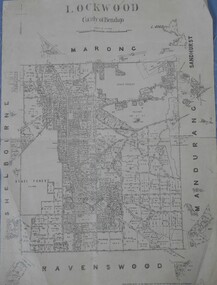 Bendigo Historical Society Inc.
Map - Lockwood County of Bendigo
A map of Lockwood in the County of Bendigo. On the back in blue pen: Lockwoodmap, lockwood -
Stawell Historical Society Inc
Map, Bolangum, County of Kara Kara, 1957
Bolangum, County of Kara Karastawell -
Stawell Historical Society Inc
Map, Navarre, County of Kara Kara, 1925 & 1955
Navarre, County of Kara Karastawell -
Stawell Historical Society Inc
Map, Landsborough, County of Kara Kara, 1954
Landsborough, County of Kara Karastawell -
Stawell Historical Society Inc
Map, Moyston West, County of Borung, 1934
Moyston West, County of Borungstawell -
Stawell Historical Society Inc
Map, Township of Stawell, County of Borung, 1958
Township of Stawell, County of Borungstawell -
Stawell Historical Society Inc
Map, Parish of Mokepilly, County of Borung
Parish of Mokepilly, County of Borungstawell -
 Bendigo Historical Society Inc.
Map - JACK FLYNN COLLECTION: COUNTY OF GLADSTONE, 1934
Map: County of Gladstone, map sheet showing the whole of the County and the Parishes within. Scale 2 Miles to 1 inch.Engraved at the Department of Lands and Survey Melbourne. 1958. By Authority of W.M. Houston, Government Printermap, gladstone, parish plan, gladstone -
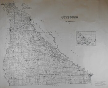 Bendigo Historical Society Inc.
Map - JACK FLYNN COLLECTION: COUNTY OF GUNBOWER, 1935
Map; County of Gunbower. Sheet containing the whole of the County, showing parishes within. Scale 2 Miles to 1 inch.map, gunbower, parish plan, gunbower -
 Kiewa Valley Historical Society
Maps - Kiewa Valley Parish Maps x3 and Kiewa Area Planimetric Map x1
Planimetric maps are 2 dimensional representations of the Earth's surface, showing the location and spatial arrangement of features such as roads, buildings, and bodies of water. The parish maps show the occupiers with leases or licences of the land. These are updated by the Department of Lands regularly. The names of early settlers of the Kiewa Valley occupying land by lease or licence are shown. Many of these familie's descendants still live in the Kiewa Valley.1. Kiewa Area Planimetric Map (photo) 2. Wermatong, County of Bogong Parish Map 3. Mulllindolingong, County of Bogong Parish Map 4. Mullagong, County of Bogong Parish Map All black and white kiewa valley. parish maps. land owners -
 Ringwood and District Historical Society
Map, Department of Mines, Plan of area applied for under the mining leases regulations in the township of Ringwood between Maroondah Highway and Mt. Dandenong Road. Mining District of Castlemaine, County of Mornington, Parish of Ringwood T Area 58(A) 2 (R)15(P) Acres, Roods, Perches. 1934, 20-Feb-34
Map of the township of Ringwood with subdivisions between Maroondah Highway and Mt. Dandenong Road. the area applied for on lease No.8210 by E.G.Browne.Mining District of Castlemaine, County of Mornington, Parish of Ringwood T Area 58(A) 2 (R)15(P) Acres, Roods, Perches.Buff coloured sheet foolscap with black printing showing map of the township of Ringwood between Maroondah Highway and Mt. Dandenong Road. Mining District of Castlemaine, County of Mornington, Parish of Ringwood T Area 58(A) 2 (R)15(P) Acres, Roods, Perches +Additional Keywords: Browne E.G. -
Whitehorse Historical Society Inc.
Map, Plan of special survey selected by H. Elgar Esq, 1841
Photocopy of plan and listing of corner stakes.Photocopy of plan and listing of corner stakes. Note on verso: Plan of special survey selected by H. Elgar Esq in the Parishes of Boroondara and Nunawading, County of Bourke. Surveyed by T.H. Nott (?Sydney) 31 May 1841. Boroondara Special Survey B.17, with attached descriptive note by T. H. Nott.Photocopy of plan and listing of corner stakes. maps, parish of boroondara, parish of nunawading, elgar, h, nott, t.h. -
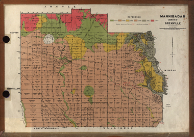 Federation University Historical Collection
Plan, Mannibadar Geological plan
Coloured plan of Mannibadar, County of Grenville.mannibadar, pitfield, mount bute, emu hills, woady yalouk river, geology, plan -
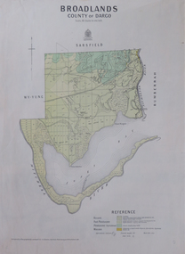 Federation University Historical Collection
Map, Broadlands, County of Dargo, 1887
Plan of Broadlands, County of Dargo, Victoria.broadford, j.g. easton, dargo, geological -
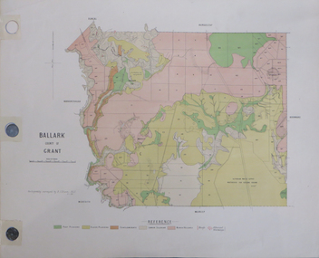 Federation University Historical Collection
Plan, Ballark: County of Grant, 05/01/1889
A geological plan of Ballark in the County of Grant.moreep, mount wallace, ballark -
Stawell Historical Society Inc
Map, Ledcourt, County of Borung, Shire of Stawell, 1957
Ledcourt, County of Borung, Shire of Stawellstawell -
Stawell Historical Society Inc
Map, Mokepilly, County of Borung, Shire of Stawell, 1957
Mokepilly, County of Borung, Shire of Stawellstawell -
Stawell Historical Society Inc
Map, Riachella, County of Borung, Shire of Stawell, 1920
Riachella, County of Borung, Shire of Stawellstawell