Showing 188 items
matching dirt road
-
 Glenelg Shire Council Cultural Collection
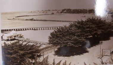
Postcard - Postcard - Portland Harbour, 1930s
... , a dirt road with an RACV sign bridging it to the right... protruding from it. In the foreground are trees, a dirt road ...Owned by James and Ada Brimblecomber, Heywood, and then by Merle Lewis, Mt. Gambier.Black and white photographic image of a harbour with two long piers running into it and a shorter jetty with a building on it and a circular jetting protruding from it. In the foreground are trees, a dirt road with an RACV sign bridging it to the right and a railway track visible between the trees.Front: THE HARBOUR, PORTLAND (printed, lower centre) -
 Federation University Historical Collection
Photograph - Photograph (Black & White), Mines Department, Back View School of Mines Ballarat, c 1900
... , and Albert Street is an unmade dirt road.... is an unmade dirt road. Back View School of Mines Ballarat Photograph ...The Albert Street end of the Ballarat School of Mines Campus included the Gauge Tower [designed by Henry R. Caselli] and the Mining Laboratory. The buildings shown along Albert Street have been demolished to make way for the M.B. John Building and the Flecknoe Building. Black and white photograph mounted onto green card. Shows the Ballarat School of Mines from Albert Street. The Henry Caselli designed Gauge tower is located on the left hand side of the photo, and Albert Street is an unmade dirt road.Written onto bottom of photo 'Back View School of Mines Ballarat. Mines Dept.ballarat school of mines, albert street, henry caselli, henry richards caselli, hr caselli -
 Bendigo Historical Society Inc.
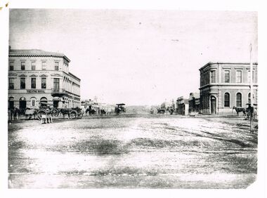
Photograph - WES HARRY COLLECTION: THEATRE ROYAL AND BANK OF AUSTRALASIA, WILLIAMSON ST. SANDHURSTG
... . On opposite corner Bank of Australasia. Dirt Roads, horse... of Australasia. Dirt Roads, horse and carriages on roadway. Horse trough ...Black and white image copy: image shows Theatre Royal, three storey building, on corner of Williamson Street. On opposite corner Bank of Australasia. Dirt Roads, horse and carriages on roadway. Horse trough on LH side on side of road.Batchelderplace, bendigo, theatre royal, bank of australasia, bendigo, sandhurst, bank of australasia, theatre royal -
 Lakes Entrance Historical Society
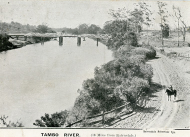
Postcard - Bridges, 1906
... on dirt road to Metung beside the river. Punt previously used...First timber road bridge over the Tambo River at Swan Reach ...First timber road bridge over the Tambo River at Swan Reach officially opened 20 December 1905, after which punt was removed to BairnsdaleBlack and white postcard of the lifting bridge over the Tambo River at Swan Reach, Victoria. Man on horse standing on dirt road to Metung beside the river. Punt previously used to cross river visible against western bank of river.Tambo River (16 miles from Bairnsdale)bridges, waterways -
 Bendigo Historical Society Inc.
Photograph - HARVEY TOWN, EAGLEHAWK, 1960's ?
... , Eaglehawk. Dirt road, with dirt footpath. Two stone cottages on RH...: streetscape of Harvey Town, Eaglehawk. Dirt road, with dirt footpath ...Black and white photograph: streetscape of Harvey Town, Eaglehawk. Dirt road, with dirt footpath. Two stone cottages on RH side of photo, white painted stone ( ? ) cottage with a verandah on LH side of photo. Cottages have iron roof, brick chimneys. A wire fence runs across the front of the cottages. A. Doney photo ?place, streetscape, harvey town -
 Glenelg Shire Council Cultural Collection
Postcard - Postcard - The Harbour, Portland, n.d
... , a dirt road with an RACV sign bridging it to the foreground right... it. In the foreground are trees, a dirt road with an RACV sign bridging ...Black and white photographic image of a harbour with two long piers running into it and a shorter jetty with a building on it and circular jetty protruding from it. In the foreground are trees, a dirt road with an RACV sign bridging it to the foreground right and a railway track visible between the trees.Front: THE ROSE SERIES P. 10771/ COPYRIGHT (typed, lower left) THE HARBOUR, PORTLAND (typed, lower centre) -
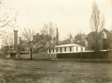
 National Wool Museum
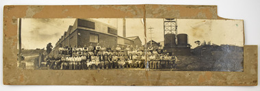
Photograph - Staff Group Portrait, Collins Bros Mill Pty Ltd, 1930s-1940s
... , a chimney, towers, tanks, farmland, a car, powerlines and dirt roads..., farmland, a car, powerlines and dirt roads are shown ...The Collins No. 2 Woollen Mill building dates from around the 1930s, however related buildings at that site were first constructed from around 1918, that was the Marnock Vale Wool Scouring Works. The Union Woollen Mill founded in the 1870s by William Henry Collins, a major Geelong industrial enterprise, was among the local firms which flourished during the First World War period. From 1914-1918 Collins Bros. concentrated on equipment for the A. I. F. However, afterwards Collins Bros. Pty. Ltd. specialised in the manufacture of flannels and blankets. From 1920 to 1938 the output was increased by fifty percent, and the number of employees rose to 200. The Collins Bros. No. 2 Mill was established in Bridge Street, Newtown. The proprietary brand 'Physician' became well and favourably known throughout Australia source: Heritage Victoria The Collins Bros Mills No. 1 and No. 2 hired over 250 people, and produced between 40,000 and 60,000 blankets for both the Australian market and for overseas export. Collins Bros closed both mills in 1974.Landscape photograph mounted on board showing a group portrait of staff seated and standing together in front of the Collins No. 2 Woollen Mill, Bridge Street, Newtown. Buildings, a chimney, towers, tanks, farmland, a car, powerlines and dirt roads are shown in the background. -
 Phillip Island and District Historical Society Inc.
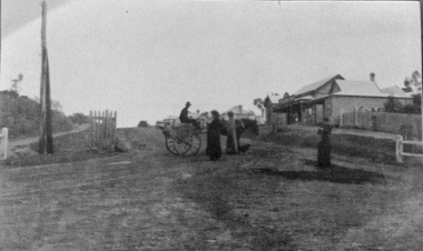
Photograph, Main Street, Cowes
... , showing dirt road with buildings on the right side.Looking south..., showing dirt road with buildings on the right side.Looking south ...Building on the right is Robb Brothers StoreCopy of a sepia photo of Main Street,[Thompson Ave] Cowes, showing dirt road with buildings on the right side.Looking south uphill along Thompson Ave. A man on a jinker on road talking to 2 women and another woman standing on right side of road.Main Street [Thompson Ave] Cowes. Robb Bros Storecowes, thompson avenue cowes, photographs, transport - jinker, robb brothers -
 Bendigo Historical Society Inc.
Photograph - WES HARRY COLLECTION: POST OFFICE, VIEW STREET, BENDIGO
... stone building, verandah in front and side. Tile roof. Dirt... and side. Tile roof. Dirt road in front. Men and boy standing ...Black and white photo copy : image shows single storey stone building, verandah in front and side. Tile roof. Dirt road in front. Men and boy standing in front of building. Lamp Post on RH side. Post Office in View Street.Batchelderplace, building, post office -
4th/19th Prince of Wales's Light Horse Regiment Unit History Room
Framed Colour Photo
... of Wales's Light Horse Regiment parked nose to tail on dirt road... on dirt road in desert country of Northern Victoria. Crews ...Annual camp of 4/19 Prince of Wales's Light Horse Regiment, in desert country of Northern Victoria, about 1982 Colour photo of squadron of M113A1 of 4/19 Prince of Wales's Light Horse Regiment parked nose to tail on dirt road in desert country of Northern Victoria. Crews are on tops of vehicles waiting for something to happen. In glass fronted wooden frame. Landscape orientation. desert camp, m113a1, -
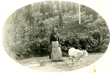 Mt Dandenong & District Historical Society Inc.
Photograph
... to a small cart loaded with collected firewood. They are on a dirt... cart loaded with collected firewood. They are on a dirt road ...Photograph likely taken on Childs Road in Kalorama in the early 1900s.Black and white photograph showing a woman with a long dress, apron and headscarf leading a got that is hitched to a small cart loaded with collected firewood. They are on a dirt road with bush above them. The photograph has been produced in postcard format with the picture in an oval in the centre of white frame.goat, wood collection, cart, wood, kalorama, childs road -
 Linton and District Historical Society Inc
Photograph, Grey Street, Linton
... Sepia photograph showing several houses along a dirt road... along a dirt road open area with some trees, footbridge on RHS ...Sepia photograph showing several houses along a dirt road open area with some trees, footbridge on RHS. Shire Engineer's house (formerly house owned by Hubert Adams, newspaper proprietor) is on corner of road to Devil's Kitchen. Glimpse of Murrell's Victoria Hotel in distance."Esther Cluff Linton".buildings, houses, shire of grenville engineer's house -
 Bendigo Historical Society Inc.
Photograph - WES HARRY COLLECTION: WEATHERBOARD MINERS' COTTAGE
... with two women and child. Dirt road, sloping upwards to LH side... standing in garden with two women and child. Dirt road, sloping ...Black and white copy: image shows double fronted miners' cottage, side entrance with timber fretwork on RH side, additional room at rear. Picket fence in front, man standing in garden with two women and child. Dirt road, sloping upwards to LH side of image.Batchelderplace, bendigo, miners' cottage, bendigo, sandhurst, miners' cottage, picket fence -
![Postcard - Digital image, Main Road Greensborough [showing Methodist Church], 1902](/media/collectors/4f729f5697f83e03086015b8/items/54e05e832162f11b9403aebc/item-media/54e05ead2162f11b9403b247/item-fit-380x285.jpg) Greensborough Historical Society
Greensborough Historical SocietyPostcard - Digital image, Main Road Greensborough [showing Methodist Church], 1902
... on the dirt road. Today Main Street Greensborough is a busy commercial... and small houses on the dirt road. Today Main Street Greensborough ...This postcard of Main 'Road' Greensborough looking north shows the Methodist Church to the left and small houses on the dirt road. Today Main Street Greensborough is a busy commercial area. The postcard was addressed to Miss A Medhurst. Amy Medhurst married Jim Knapsey.The Methodist Church was sited near the present entrance to Greensborough Plaza and was demolished during the Plaza's development.Digital copy of sepia postcard [damaged]Caption on back of card.methodist church greensborough, main street greensborough, medhurst family -
 Bendigo Historical Society Inc.
Photograph - WES HARRY COLLECTION: BRICK INDUSTRIAL BUILDING
... on footpath. Dirt road. Market Building ?... be photographer's cart on footpath. Dirt road. Market Building ? Photograph ...Black and white photo, copy: image shows large brick building, two arched entranceways under flat façade. 3 arched windows, iron bars. Skylights on top of building. Man sitting on footpath to left of building, could be photographer's cart on footpath. Dirt road. Market Building ?Batchelderplace, bendigo, market building, bendigo, sandhurst, goldmining, market building -
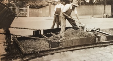
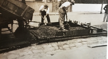 Kew Historical Society Inc
Photograph - Street Works, Studley Park Road, March 1934
... a dirt road. Street works during the Great Depression included... Studley Park Road, like most streets in Kew, was originally a dirt ...Studley Park Road, like most streets in Kew, was originally a dirt road. Street works during the Great Depression included bituminising major roads in the district. This photograph of Council works originated in the City of Kew Engineers Department as a record of works undertaken. It was given to the collection by a Mrs Fisher in 1998.Well provenanced photograph of Council-funded public works in Kew during the Great Depression. Original sepia monochrome positive of Council workers spreading bitumen in Studley Park Road, Kew.Typed reverse: "B4 / Kew C.C. / Spreading premixed material on Studley Park Road with drag spreader, March 1934"roadworks -- kew (vic.), street works -- kew (vic.), public works kew (vic.), studley park road -- kew (vic.), city of kew -- engineers department, city of kew -- public works -- great depression -- 1930s -
 Kew Historical Society Inc
Photograph - Street Works, Studley Park Road, March 1934
... a dirt road. Street works during the Great Depression included... Studley Park Road, like most streets in Kew, was originally a dirt ...Studley Park Road, like most streets in Kew, was originally a dirt road. Street works during the Great Depression included bituminising major roads in the district. This photograph of Council works originated in the City of Kew Engineers Department as a record of works undertaken. It was given to the collection by a Mrs Fisher in 1998.Well provenanced photograph of Council-funded public works in Kew during the Great Depression. Original sepia monochrome positive of Studley Park Road, Kew.Typed reverse: "B4 / Kew C.C. / Studley Park Road after surfacing with one coat of premixed material spread with drag, March 1934"roadworks -- kew (vic.), street works -- kew (vic.), public works kew (vic.), studley park road -- kew (vic.), city of kew -- engineers department, city of kew -- public works -- great depression -- 1930s -
 Kew Historical Society Inc
Photograph - Street Works, Studley Park Road, March 1934
... a dirt road. Street works during the Great Depression included... Studley Park Road, like most streets in Kew, was originally a dirt ...Studley Park Road, like most streets in Kew, was originally a dirt road. Street works during the Great Depression included bituminising major roads in the district. This photograph of Council works originated in the City of Kew Engineers Department as a record of works undertaken. It was given to the collection by a Mrs Fisher in 1998.Well provenanced photograph of Council-funded public works in Kew during the Great Depression. Original sepia monochrome positive of Council workers standing on and beside a dray in Studley Park Road, Kew while resurfacing of the street was taking place. The Kew Junction is just visible behind the men.Typed reverse: "B4 / Kew C.C. / Spreading premixed material on Studley Park Road with drag spreader, view from rear of machine, March 1934"roadworks -- kew (vic.), street works -- kew (vic.), public works kew (vic.), studley park road -- kew (vic.), city of kew -- engineers department, city of kew -- public works -- great depression -- 1930s -
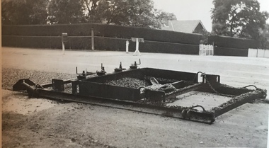 Kew Historical Society Inc
Photograph - Street Works, Studley Park Road, March 1934
... a dirt road. Street works during the Great Depression included... Studley Park Road, like most streets in Kew, was originally a dirt ...Studley Park Road, like most streets in Kew, was originally a dirt road. Street works during the Great Depression included bituminising major roads in the district. This photograph of Council works originated in the City of Kew Engineers Department as a record of works undertaken. It was given to the collection by a Mrs Fisher in 1998.Well provenanced photograph of Council-funded public works in Kew during the Great Depression. Original sepia photographic positive of a drag used to spread bitumen in Studley Park Road, Kew.Typed reverse: "B4 / Kew C.C. / Drag spreader used for premixed material on Studley Park Road, showing end of strip just with spread, with unsurfaced work on left and completed section on right, March 1934"roadworks -- kew (vic.), street works -- kew (vic.), public works kew (vic.), studley park road -- kew (vic.), city of kew -- engineers department, city of kew -- public works -- great depression -- 1930s -
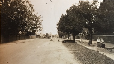 Kew Historical Society Inc
Photograph - Street Works, Studley Park Road, March 1934
... a dirt road. Street works during the Great Depression included... Studley Park Road, like most streets in Kew, was originally a dirt ...Studley Park Road, like most streets in Kew, was originally a dirt road. Street works during the Great Depression included bituminising major roads in the district. This photograph of Council works originated in the City of Kew Engineers Department as a record of works undertaken. It was given to the collection by a Mrs Fisher in 1998.Well provenanced photograph of Council-funded public works in Kew during the Great Depression. Original sepia photographic positive of Studley Park Road, Kew while resurfacing of the street was taking place. The Kew Junction is just visible in the distance. Boys sitting on a drum at right. Behind them is the brick fence and front entrance to Tara Hall.Typed reverse: "B4 / Kew C.C. / Studley Park Road showing drag spread surfacing with premixed material, unrolled material on the right, March 1934"roadworks -- kew (vic.), street works -- kew (vic.), public works kew (vic.), studley park road -- kew (vic.), city of kew -- engineers department, city of kew -- public works -- great depression -- 1930s -
 Kew Historical Society Inc
Photograph - Street Works, Studley Park Road, March 1934
... a dirt road. Street works during the Great Depression included... Studley Park Road, like most streets in Kew, was originally a dirt ...Studley Park Road, like most streets in Kew, was originally a dirt road. Street works during the Great Depression included bituminising major roads in the district. This photograph of Council works originated in the City of Kew Engineers Department as a record of works undertaken. It was given to the collection by a Mrs Fisher in 1998.Well provenanced photograph of Council-funded public works in Kew during the Great Depression. Original sepia photographic positive of Studley Park Road, Kew while resurfacing of the street was taking place. Typed reverse: "B4 / Kew C.C. / Spreading premixed material on Studley Park Road with drag spreader, March 1934"roadworks -- kew (vic.), street works -- kew (vic.), public works kew (vic.), studley park road -- kew (vic.), city of kew -- engineers department, city of kew -- public works -- great depression -- 1930s -
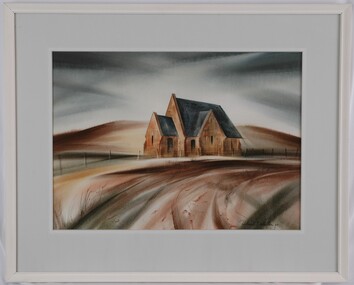 Glenelg Shire Council Cultural Collection
Painting, Robert Miller et al, Old Church Portland, 1965
... landscape. Within the foreground is a sweeping corner of a dirt road... landscape. Within the foreground is a sweeping corner of a dirt road ...CEMA Art CollectionThe painting depicts a church in an otherwise empty landscape. Within the foreground is a sweeping corner of a dirt road. Along the edge of the road runs a simple fence. Behind the church is a bare yellow and brown hill which reaches into a dark sky. The work has a wooden, white painted frame with grey mount and white trimming and glass.Front: Robert T. Miller 75 (lower right, black signature) Back: ROBERT MILLER " OLD CHURCH PORTLAND" (1966) (lower right, typed) Watercolourportland, church, streetscape, religion -
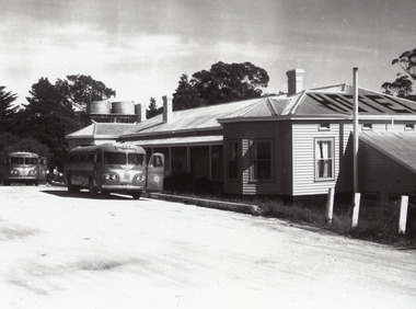 Lakes Entrance Historical Society
Photograph - Kalimna Hotel, 1960c
... on the Eastern end of the hotel. Dirt road at front with two Ansett buses... of the hotel. Dirt road at front with two Ansett buses and people ...This is the before paired photograph used in the 150 year, Lakes Entrance 1858-2008 display.|The after paired photograph number is 01335.1|Also one 12 x 16 framed photograph used in room display.| The hotel was owned by Ansett and used by their coaches for a meal stop-off point. The Kalimna is often referred to as the Hotel with a View.Black and white enlarged photograph showing original Kalimna Hotel prior to a fire in 1962 which burnt the old bar on the Eastern end of the hotel. Dirt road at front with two Ansett buses and people in front of hotel. Two water tanks, three chimneys and hotel painted on top of roof. Lakes Entrance Victoria,restaurant, hotels, room display -
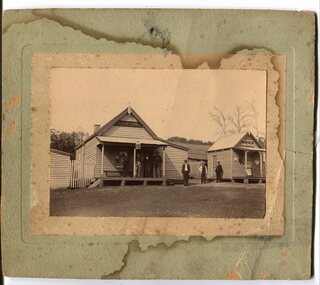 Orbost & District Historical Society
black and white photograph, early 20th century
... single-storeyed timber buildings fronting a wide dirt road... dirt road. On the right is the Bonang Hotel with four men ...The hotel at Bonang was also known as Clancy's Hotel, Bonang, after its licensee, William Clancy. It operated from the late 1890s until early 20th century. William Clancy was aslo the postmaster at Bonang. A post office operated at Bonang from at least 1859. At the time Bonang was "a small, scattered collection of buildings marking the intersection of the Bonang Highway and the McKillops Bridge Road" ( from Regional Heritage Assessment 1996). As the mining activity declined the township became even smaller as many of the population moved to Orbost,, a larger settlement. This is a pictorial record of Bonang, a small settlement approximately 50 km north of Orbost. The buildings in the photograph no longer exist.A black / white photograph mounted on grey card. there are stains from water damage on the mount. It is a photograph of two single-storeyed timber buildings fronting a wide dirt road. On the right is the Bonang Hotel with four men in suits standing on a verandah. The building on the right is the Bonang Post Office and there are three men outside it. the photograph has been posed. on back - 'Grandma Clancy owned the hotel & Uncle Will had a gold mine which he worked"bonang bonang-post-office bonang-hotel clancy-william clancy's-hotel-bonang -
 Whitehorse Historical Society Inc.
Photograph, Joyce & Elvie Johns, c1924
... of dirt road with grass paddocks on each side. Elvie, born 29... the narrow strip of dirt road with grass paddocks on each side. Elvie ...Black & white photo of Joyce & Elvie Johns, Daughters of Mr. & Mrs. F. Johns of Orient Ave Mitcham. Note the narrow strip of dirt road with grass paddocks on each side. Elvie, born 29 April 1918, married Stan Finger, Orchardist. Joyce born Sept 1920 died 1924 - Scarlett Fever.johns joyce, johns elvie, finger stan, vermont, orient ave 41 -
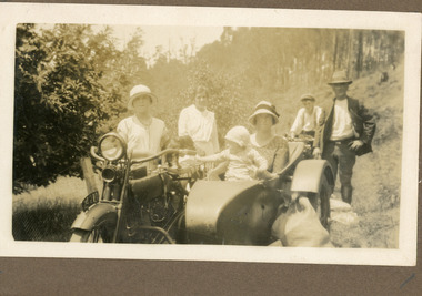 Mt Dandenong & District Historical Society Inc.
Photograph
... on a dirt road. A motorbike with side car is in the foreground... of people on a dirt road. A motorbike with side car ...The photograph is from the album of Ivy Child. Everyone in the photograph is well dressed for a day of visiting. The woman without the hat standing to the LHS appears to be Ethel Child.The location is most likely the road outside the Child Family Homestead of Ted and Ethel Child - Childs Road. Ivy May Child (1910 – 1989) was the daughter of Arthur Edward (Ted) Child (1878 – 1964) and Ethel May Madden (1888 – 1970). Ted Child was the son of Matthew Francis Child (1839 – 1933) and Martha Jeeves (1857 – 1926). He was the grandson of one of the early pioneers Francis Child. Ivy grew up on the family property on Childs Road and took many photographs. Most of these are glued into her photo album. The album covered the years from c1927 – 1932. Ivy married Henry William Burgess (1906 – 1968) in 1944. The photographs remain in their original state in the album with individual copies made. Sepia coloured photograph showing a group of people on a dirt road. A motorbike with side car is in the foreground with a woman and baby in the side car and a young woman standing beside it. Another motorbike is behind this with a young man wearing a cap sitting on it. A man wearing a hat is at the rear of the motorbike with side car and a woman without a hat is standing to the LHS. ethel child, motorbike, side car, child family homestead, kalorama -
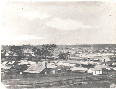 Bendigo Historical Society Inc.
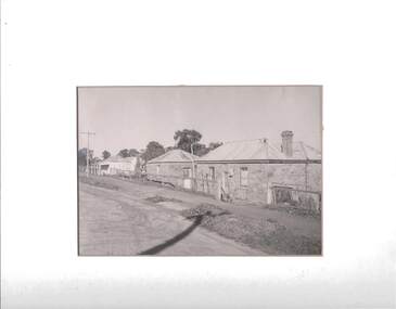
Photograph - HARRY BIGGS COLLECTION: BENDIGO LANDSCAPE VIEW OF COTTAGES, c1850's (late) Pre 1864
... . Black & white photos, Forest St in foreground - dirt road picket.... Black & white photos, Forest St in foreground - dirt road picket ...Photograph. Harry Biggs Collection. 2 Black and white streetscape of Bendigo City from Forest Street late 1850's. The long Beehive Store can be seen. In the foreground are many cottages long since gone. A stand of trees along the ridge can be seen. Black & white photos, Forest St in foreground - dirt road picket fence.photograph, streetscape, bendigo, harry biggs collection, bendigo streetscape -
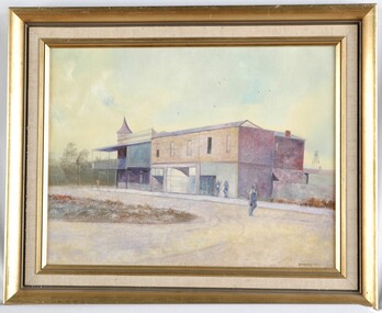 Glenelg Shire Council Cultural Collection
Painting, Down the Street, 1977
... the centre of the dirt road. Framed in gold painted wooden frame.... in overalls and carrying a bag walks along the centre of the dirt road ...UnknownView of a building on a country street. The building is large, and in 3 sections, two of which may be shops. The building on the corner has a verandah and balcony over the footpath, and may be a pub. Two people lean on the wall to the right of the building. One man in overalls and carrying a bag walks along the centre of the dirt road. Framed in gold painted wooden frame.Front: B Malloch '77 (lower left) (brown paint) Back: 1977 - (yellow sticker, upper right) Mer-ger Galleries, Picture Framing sticker, order no. 1057 (sticker, lower centre) "Dow...E Street" (blue pen on sticker, lower left, torn) -
 Lakes Entrance Historical Society
Postcard - North Arm bridge. Lakes Entrance Victoria 1905, Cooper, Alexander, 1908c
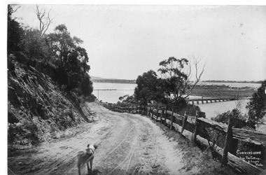
... Sepia giant post card dirt road leading to the first North... corner Sepia giant post card dirt road leading to the first North ...On back of postcard 'Postage one penny without any communication with communication ordinary letters'|This is the before paired photograph used in the 150 year Lakes Entrance 1858-2008 display|The after paired photograph number is 01147.1|Also one 12 x 16 framed photograph used in room display.|Cooper based in Paynesville 1908-1909Sepia giant post card dirt road leading to the first North Arm bridge. Horse facing two bovines on bridge, mud flat with a small jetty, Club Hotel, sand dunes facing Bass Strait. Post and Rail fence on side of road. Shaggy dog in road. Dieback of melaleuca and reeds on mudflats. Lakes Entrance VictoriaCunninghame from the Cutting A.Cooper photo- right hand cornerroads and streets, bridges, fences, animals, room display -
 Stawell Historical Society Inc
Photograph, Cemetery Crowd
... at graves. 7083-4 A Group of People on a dirt road over a small... at graves. 7083-4 A Group of People on a dirt road over a small ...7083. A Groupd of People standing inside the Cemetery Gates Stawell. 7083-1 A Group of people looking at a fenced headstone 7083-2 A Group of people looking at a Monument. With houses in the background. 7083-3 A Group of People lookning at graves. 7083-4 A Group of People on a dirt road over a small bridge, with a white ute in right foreground.5 Colour Photographs: showing a group of people at various locations looking at Graves, Monuments and a bush land site.