Showing 242 items
matching documents - maps/plans
-
 Port Melbourne Historical & Preservation Society
Document - Report, Plan of General Development, Mr J Green (Government Printer), Plan of General Development, 1929
Plan of General Development. Melbourne Report of Metropolitan Town Planning Commission, 1929. Was passed on by local history librarian as it was no longer required. On p63 shows view up Swallow Street and contrasts it with approach of St Kilda. P42 aerial view of Port Melbourne piers. Also includes maps and photographs.town planning, piers and wharves, swallow street -
 Bendigo Historical Society Inc.
Document - CONSTABLE RYAN COLLECTION: PLANS HIGHLITING PROPERTIES CONNECTED TO CASE
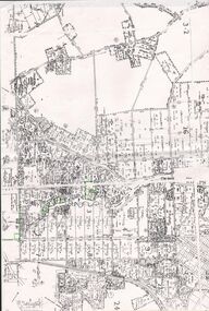
Details plans of particular properties connected to the case.map, bendigo -
 Bendigo Historical Society Inc.
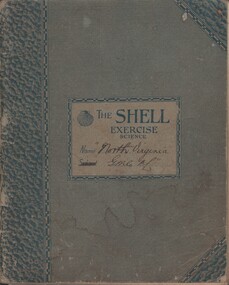
Document - MCCOLL, RANKIN AND STANISTREET COLLECTION: NORTH VIRGINIA GMC N L - CROSS SECTION PLAN OF THE MINE, 1942 1947
Document. Grey/green exercise book with 'North Virginia GMC NL. Book contains hand drawings of shafts and their metalurgical content at every depth. Symbols have been used to indicate different metals and earth. 2 maps loose in the book.McColl, Rankin & Stanistreetorganization, business, north virginia gmc n l, mccoll, rankin & stanistreet, north virginia gmc n l, gold mining, cross section plan of the north virginia -
 Bendigo Historical Society Inc.
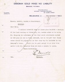
Document - MCCOLL, RANKIN AND STANISTREET COLLECTION: DEBORAH GOLD MINE NL - LEASE DOCUMENTS, 1935, 1941
Document: McColl, Rankin and Stanistreet: lease documents. 12 pages of lease details, with attached map plan on no 9672 Bendigo. ( Abel and Eve Street marked )organization, mining, deborah gold mines nl, mccoll, rankin and stanistreet: deborah gold mines nl, gold mining, lease -
 Bendigo Historical Society Inc.
Document - MCCOLL, RANKIN AND STANISTREET COLLECTION: SOUTH DEBORAH GOLD MINES NL GOLD LEASE DOCUMENT, 14/1/1941
Document: McColl, Rankin and Stanistreet - South Deborah Gold Mines NL. Gold mining lease document. No. 11141, Vol. 325, Fol. 35893. Lease adjoins Railway Reserve, Breen Street. Attached to plan with pin piece of paper, written in pencil ' application Atherton 14/4/46 - consent refused - hand drawn map with Honeybone Street.organization, mining, south deborah gold mines nl, mccoll, rankin and stanistreet, south deborah gold mines nl, gold mining lease documents -
Clunes Museum
Document - DOCUMENTS
.1 DILAPIDATION ASSESSMENT AND RESTORATION PROPOSAL FOR THE QUEENS PARK FOUNTAIN AT CLUNES, AUGUST 1993 .2 CRESWICK CREEK WALK PROJECT 2005 WITH CORRESPONDENCE FROM MICHAEL CHESHIRE .3 CLUNES WALKING TRACK WITH DETAILS OF WORK TO BE UNDERTAKEN 2005 .4 "TAKE BACK THE CREEK" COMMUNITY MEETING - AGENDA FOR MEETING 8/8/2005 .5 ACCOUNT FOR CRUSHED ROCK AND GRANITE SAND 17/05/2005 .6 MAP OF HEPBURN SHIRE SHOWING LANDCARE GROUPS .7 CTDA LETTER DATED 14/06/2005 REGARDING PLANNING WORKSHOP .8 QUEENS PARK FENCE PROJECT REPORT 2003 .9 MINUTES OF GENERAL MEETING OF CLUNES LANDCARE GROUP FROM 23/07/2002 TO 12/05/2005 .clunes landcare group, queens park fountain, creswick creek walk -
Clunes Museum
Document - PLAN, TITLE PLANS OF GLENGOWER
1 PAGE PHOTOCOPY OF MAP OF GLENGOWER3153 G(3) 28 COMPILED AUGUST 1875 COMPARED WITH ORIGINALS 5/6/1965 AND 4/8/1976photo-lithographic, glengower titles plan -
Tatura Irrigation & Wartime Camps Museum
Folder, Karlsruhe, 1987
History of "Karlsruhe" homestead on Nation Trust of historical homes built by Baon Von Swaine. Also plans maps, photographs. Tape of official opening 1986Black and white mottled binder, contains newspaper articles on renovation of Karlsruhekarlsruhe homestead, lancaster, baron von swaine, tatura, documents, history, local, newspapers -
Tatura Irrigation & Wartime Camps Museum
Document, Geological Plan, Eildon Dam Site, 1945
To record details of geological aspects of EildonA series of maps illustrating rock formations etc., locations, boundaries and planswater/irrigation, documents, maps -
 Robin Boyd Foundation
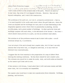
Document - Manuscript, Robin Boyd, Albert Park Protection League
Criticism of the state of Albert Park, Melbourne, preparation of a current map, the need for a Master Plan of buildings, plantings, furniture. Criticism of buildings. Suggests a plan to plant and paint.This appears to be a lecture.Typewritten with pencil edit and notes, quarto, 4 pages. (Two copies)Small paper square included with Monday, January 24 calendaralbert park, macrobertson girls high school, planting, building, furniture, robin boyd, manuscript -
Victorian Aboriginal Corporation for Languages
Conference proceedings, Joe Blythe, Maintaining the links : language, identity and the land : proceedings of the Seventh FEL Conference, Broome, Western Australia, 22-24 September 2003, 2003
Major headings: Languages & Land claims; Toponymy & Topography; Planning for the future; Language, identity & the environment; Language & Identity: Home & Away; Language revitalisation: Maintenance; Documenting ENdangered LanguagesMaps, graphs, word listsland claims, east kimberley, ecotourism, nsw, borroloola, gurr-goni, maningrida -
 Victorian Aboriginal Corporation for Languages
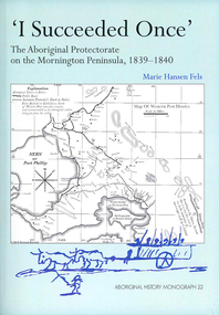
Book, Marie Hansen Fels, I succeeded once : the Aboriginal Protectorate on the Mornington Peninsula, 1839-1840, 2011
1. The writings of William Thomas 2. The Context 3. The record of observation 4. Tubberubbabel, Protectorate head station 5. Kangerong, Protectorate second station 6. Buckkermitterwarrer, Protectorate third station 7. Kullurk, the Bonurong choice for a reserve 8. The raid into Gippsland and the massacres remembered 9. Manufacturing industry on the Mornington Peninsula, 'the successful plan at Arthurs Seat' 10. Death of Johnny and his burial on the foreshore at McCrae 11. The abduction between Arthurs Seat and Point Nepean, and Yankee Yankee's return 12. Thomas' translations.maps, document reproductions, b&w illustrations, colour illustrations, colour photographsboon wurrung, yarra mission, william thomas -
 Victorian Aboriginal Corporation for Languages
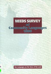
Book, Aboriginal and Torres Strait Islander Commission Broadcasting, Languages, Arts and Culture Section, Needs survey of community languages 1996, 1996
The survey aims to document the Indigenous language situation and to establish the extent of Indigenous language needs so as to provide a sound basis for further program planning.maps, surveyeducation policy, language policy -
Clunes Museum
Map - MAPS/ DOCUMENTS, CIRCA 1857
COLLECTION OF DOCUMENTS (COPIES OF10 MAPS AND DIAGRAMS OF TOURAAL PURCHASED UNDER PREEMPTIVE RIGHT BY DONALD CAMEROM 17TH FEBRUARY, 1857. COUNTY OF TALBOT - GOLDFIELD'S SURVEY PLAN NO.1 CLUNES COUNTY OF TALBOT. GLENDONALD - CRESWICK/CLUNES.local history, mining -
Clunes Museum
Document, VICTORIAN GOVERNMENT DEPT. OF PLANNING, THE RURAL LAND MAPPING PROJECT 1981 - DRAFT, JULY 1981
A REPORT TO THE SHIRE OF TALBOT AND CLUES TO ACCOMPANY AND EXPLAIN THE SET OF PHYSICAL CONSTRAINTS MAPS PRODUCED FOR THE SHIRE AS PART OF THE RURAL LAND MAPPING PROJECT...SOFT COVER, TAN COLOURED DRAFT OF THE RURAL MAPPING PROJECT 1981 - SHIRE OF TALBOT AND CLUNES.non-fictionA REPORT TO THE SHIRE OF TALBOT AND CLUES TO ACCOMPANY AND EXPLAIN THE SET OF PHYSICAL CONSTRAINTS MAPS PRODUCED FOR THE SHIRE AS PART OF THE RURAL LAND MAPPING PROJECT...local history, government, state government, essential services -
Clunes Museum
Plan - PLAN/MAP, SOUTH CLUNES GOLD MINE
PLAN AND MAP OF SOUTH CLUNES GOLDMINEPLAN OF SOUTH CLUNES UNITED G.M.CO.CLUNES PRODUCED OR DRAWN BY F.W.NIVEN & CO LITH BALLARATlocal history, document, mining, plans -
Clunes Museum
Map, F.W. NIVEN EMBOSSER
SCROLL - SURVEVOR MAP AND PLAN OF NEW CRESWICK GOLD FIELDS SURFACE LEVELSlocal history, document, maps, mining - maps -
Clunes Museum
Map - MAPS
ORIGINAL MAP SHIRE OF TALBOT AND CLUNES. LOCALITY PLAN, SEALED ROADS, BITUMEN ROADS, GRAVEL OR SAND ROADS, UNMADE OR PART FORMED ROADS.local history, document, maps, talbot, clunes shire -
Whitehorse Historical Society Inc.
Document, Eastern Freeway Extension, 2000 - 2002
Eastern Freeway ExtensionEastern Freeway Extension- Cost estimates for community consultation option Public consultation process : report on analysis submissions Deep Creek Road - Landscape concept Media Release from Premier of Victoria VicRoads - Works update newsletters Whitehorse City Council minutes VicRoads Correspondence Schwerkolt Cottage Precinct - Concept Plan VicRoads maps.Eastern Freeway Extensioneastern freeway extension, vicroads, victoria. department of infrastructure, city of whitehorse, schwerkolt cottage, landscape planning, maps -
Whitehorse Historical Society Inc.
Document, Historical maps and plans, 1855 1889
... of historical maps and plans - Crown Lands Department Copy of catalogue ...Copy of catalogue of historical maps and plans - Crown Lands DepartmentCopy of catalogue of historical maps and plans - Crown Lands DepartmentCopy of catalogue of historical maps and plans - Crown Lands Departmentmaps, historical maps -
 Whitehorse Historical Society Inc.
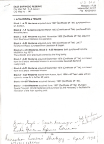
Letter - Correspondence, East Burwood Reserve, 1993
Various documents relating to the establishment of East Burwood ReserveVarious documents relating to the establishment of East Burwood Reserve including acquisition of land, details, plans, locality map, news cuttings and photographs. Appears to be copy of Nunawading City Council File April 1993Various documents relating to the establishment of East Burwood Reserve sportsgrounds, east burwood reserve, soilleur (dr), hitchens, anna, blue moon fruit co-operative ltd., jacobson and logan, king family, central methodist mission, aussat, tally ho, sewart, bill -
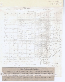 Whitehorse Historical Society Inc.
Document, The Village of Norwich, C1862
Map showing the planned village of NorwichMap showing the planned village of Norwich in Vermont about 1862Map showing the planned village of Norwichland settlement, morack road, vermont south, barkly street, vermont, george street, william street -
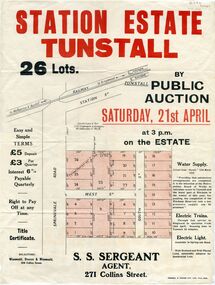 Whitehorse Historical Society Inc.
Pamphlet - Document, Station Estate Tunstall, 1923
Land Plan for auction of estate at Tunstall.Land Plan for auction of estate at Tunstall. Original in Haughton Maps, Latrobe LibraryLand Plan for auction of estate at Tunstall. auctions, station estate tunstall, s. s. sergeant (agent) -
Whitehorse Historical Society Inc.
Document, Australian Social History House Research Assignment, 1986
Social History of 2 Gordon Crescent, Blackburn,Social History of 2 Gordon Crescent, Blackburn, included - History of Blackburn, Architecture of the House and first owner, Thomas Richards Burrowes. Morton. Real Estate Brochures, Maps, Photos, Floor Plans.Social History of 2 Gordon Crescent, Blackburn, morton thomas richards burrowes, architecture -
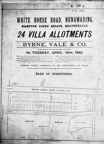 Whitehorse Historical Society Inc.
Document, Hampton Court Estate
Plan of subdivision Hampton Court EstatePlan of subdivision Hampton Court Estate Whitehorse Road, Nunawading 1882. Original in Vale Maps LaTrobe LibraryPlan of subdivision Hampton Court Estate hampton court estate, byrne vale & co. -
Whitehorse Historical Society Inc.
Document, Municipal Chambers, Nunawading, 23/07/2001 12:00:00 AM
Papers relating to applications for Council permits, objections and VCAT hearingsPapers relating to applications for Council permits, objections and VCAT hearings concerning development of 360-362 Whitehorse Road, Nunawading, and of 13 Walkers Road, Nunawading. Includes maps, plans, photos and architectural assessment of 360 Whitehorse Road by Andrew Ward.Papers relating to applications for Council permits, objections and VCAT hearings associated planning consultants, arrowsmith, valda, nunawading and district historical society, municipal chambers, whitehorse road, nunawading, no 360, no 362, walkers road, no. 13, victorian civil and administrative tribunal, ward, andrew, city of whitehorse -
Whitehorse Historical Society Inc.
Document - Correspondence, Letter and Map Schwerkolt houses, 9/11/1993
Letter to W. Gray, Nunawading Historical Society from Glyn France enclosing map of Schwerkolt property and rough plan of old stone house drawn by Arthur Schwerkolt [map filed at A-SP 120]. Gives information about dates of building 'old' and 'new' houses.schwerkolt, arthur, schwerkolt, myra, france glyn, schwerkolt cottage -
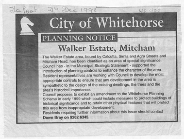 Whitehorse Historical Society Inc.
Document - Article, Planning Notice, 21/12/1998 12:00:00 AM
... . Includes map of area. Planning Notice Document Article ...Planning Notice concerning the Walker Estate in Mitcham. Amendment to the Whitehorse Planning Scheme could include protection of buildings of historical significance, proposed early in 1999. Includes map of area.maps, walker estate, mitcham road, mitcham, calcutta street, mitcham, delhi street, mitcham, agra street, mitcham, simla street, mitcham, benares street, mitcham, meerut street, mitcham, the strand, mitcham, percy street, mitcham, stanley grove, mitcham, bray, dawn -
 Whitehorse Historical Society Inc.
Legal record - Document, Melbourne Metropolitan Planning Scheme, 1987
Explanatory Statement of Amendment 500 to Melbourne Metropolitan Planning Scheme, including map of area (South of Blackburn Station). To be exhibited from 2 October 1987 to 22 December 1987.roads and streets, victoria. ministry for planning and environment, city of nunawading, south parade, blackburn, blackburn road, blackburn, main street, blackburn -
 Whitehorse Historical Society Inc.
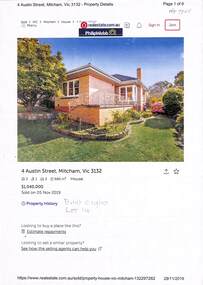
Document - Various including maps, titles, posters, Land ownership of 4 Austin Street, Mitcham, 1873 - 2019
Ownership history of 4 Austin Street, Mitcham.Ownership history of 4 Austin Street, Mitcham between 1873 to 2019, including the plan of the Mellorton Estate, Mitcham (1923), showing some lots priced at one hundred and forty-five pounds and the Charlesworth Estate ((1913). The Austin Street house was purchased by Martin and Shirley Gleeson 1956 and sold in 2019. Subdivision map of area south of Burnett Street to Harrison Street. non-fictionOwnership history of 4 Austin Street, Mitcham.drake real estate, charlesworth estate mitcham, mellorton estate mitcham, austin street mitcham no4, ainger frank