Showing 85 items
matching documents - maps/records
-
 Kew Historical Society Inc
Photograph, Floods in North Kew, 1934
Living with natural processes was frequently a challenge to early European settlers and later residents of what was in the 1850s administered by the Borondara Road Board. This was compounded by the area being bounded on three sides by rivers (Yarra River, Koonung Creek and Gardiner's Creek). In 1849, the historian James Bonwick recorded that "our district [Kew] suffered considerably. Mr Wade speaks of 80 acres, out of 100 acres of his cultivated paddock, covered by water." Newspapers continued to describe major flooding in Kew in 1863, 1869, 1878, 1880, 1889, 1891, 1916 and 1934. While the construction of the Upper Yarra dam in 1957 reduced the levels of flowing downstream, local and riverine floods continue.The Kew Historical Society's pictures and map collections testify to the impact of flooding in the district. They have historical importance in documenting the extent of flooding in the district and its affects on homes, services and recreation. Numerous photographs record flooding throughout the Twentieth Century.Floods in North Kew, 1934. Chipperfield's Boat House under flood.floods (kew) 1934, yarra river, chipperfield's boat house -
 Kew Historical Society Inc
Photograph, Floods in North Kew, 1934
Living with natural processes was frequently a challenge to early European settlers and later residents of what was in the 1850s administered by the Borondara Road Board. This was compounded by the area being bounded on three sides by rivers (Yarra River, Koonung Creek and Gardiner's Creek). In 1849, the historian James Bonwick recorded that "our district [Kew] suffered considerably. Mr Wade speaks of 80 acres, out of 100 acres of his cultivated paddock, covered by water." Newspapers continued to describe major flooding in Kew in 1863, 1869, 1878, 1880, 1889, 1891, 1916 and 1934. While the construction of the Upper Yarra dam in 1957 reduced the levels of flowing downstream, local and riverine floods continue.The Kew Historical Society's pictures and map collections testify to the impact of flooding in the district. They have historical importance in documenting the extent of flooding in the district and its affects on homes, services and recreation. Numerous photographs record flooding throughout the Twentieth Century.Floods in North Kew, 1934. Flood near the lagoon (Billabong?)floods (kew) 1934, yarra river -
 Kew Historical Society Inc
Photograph, Chipperfield's Boat House & Floating Pontoon, 1934
Living with natural processes was frequently a challenge to early European settlers and later residents of what was in the 1850s administered by the Borondara Road Board. This was compounded by the area being bounded on three sides by rivers (Yarra River, Koonung Creek and Gardiner's Creek). In 1849, the historian James Bonwick recorded that "our district [Kew] suffered considerably. Mr Wade speaks of 80 acres, out of 100 acres of his cultivated paddock, covered by water." Newspapers continued to describe major flooding in Kew in 1863, 1869, 1878, 1880, 1889, 1891, 1916 and 1934. While the construction of the Upper Yarra dam in 1957 reduced the levels of flowing downstream, local and riverine floods continue. A number of boat houses operated on both sides of the River Yarra at Kew. Chipperfield's Boat House was located on the Yarra near the corner of Kilby and Willsmere Roads.The Kew Historical Society's pictures and map collections testify to the impact of flooding in the district. They have historical importance in documenting the extent of flooding in the district and its affects on homes, services and recreation. Numerous photographs record flooding throughout the Twentieth Century.Floating pontoon at Chipperfield's Boat House where the canoes were stored, taken in 1934, presumably before the 1934 Flood. This area of the Yarra was shallow with a number of mid river sandbanks and a popular swimming area for locals.yarra river, chipperfield's boathouse, pontoon -
 Bacchus Marsh & District Historical Society
Document, Family History Files, Bacchus Marsh & District
Family History files relating to families and individuals from the township of Bacchus Marsh and its surrounding district. Files may contain family trees, replies to research inquiries, obituaries, biographical material, photocopies of published and unpublished material from books, newspapers, magazines, pamphlets, maps, archival sources and personal papers. Material may also include copies data from births, marriages, deaths, funeral, cemeteries and other genealogical registers and indexes. of Other material includes printouts of website pages, and photocopies or printouts of images. Arranged in A-Z sequence by family surname.Paper documents in ring and lever arch foldersFamily History files relating to families and individuals from the township of Bacchus Marsh and its surrounding district. Files may contain family trees, replies to research inquiries, obituaries, biographical material, photocopies of published and unpublished material from books, newspapers, magazines, pamphlets, maps, archival sources and personal papers. Material may also include copies data from births, marriages, deaths, funeral, cemeteries and other genealogical registers and indexes. of Other material includes printouts of website pages, and photocopies or printouts of images. Arranged in A-Z sequence by family surname.obituaries, funeral notices, death notices, births, marriages, cemetery records -
 Wodonga & District Historical Society Inc
Booklet - Hume and Hovell Centenary Celebrations Booklet
This souvenir was created as part of the celebrations to commemorate the journey of Hume and Hovell from New South Wales (Near Yass) to Port Phillip Bay, passing through the site of modern day Albury and Northeast Victoria.A small booklet printed for celebrations to commemorate the centenary of the journey of Hume and Hovell, including maps and advertising.fictionThis souvenir was created as part of the celebrations to commemorate the journey of Hume and Hovell from New South Wales (Near Yass) to Port Phillip Bay, passing through the site of modern day Albury and Northeast Victoria.hume & hovell, hume & hovell centenary -
 Wodonga & District Historical Society Inc
Book - Meteorological Study Albury Wodonga District March 1974, Australian Government Publishing Service
... , maps and data documenting meteorological observations ...A compilation of historical records, tables, maps and data documenting meteorological observations throughout the Albury- Wodonga district. Records for Albury date from 1860 and those for Wodonga date from 1898. Other areas documented include Beechworth, Yackandandah and Corowa.A plain covered publication. Pages are stapled stapled together down the left side of pages.A compilation of historical records, tables, maps and data documenting meteorological observations throughout the Albury- Wodonga district. Records for Albury date from 1860 and those for Wodonga date from 1898. Other areas documented include Beechworth, Yackandandah and Corowa.meteorology wodonga, meteorology albury, historical weather statistics, climate albury-wodonga -
 Wodonga & District Historical Society Inc
Album - Hume Reservoir Australia Album - Plans and Progress Photos - River Murray Water Scheme, Department of Public Works, N.S.W, 1927
This set of photos is from a leather bound album bearing the inscription "HUME RESERVOIR AUSTRALIA" plus 'The Rt. Hon. L. C. M. S. Amery, P. C., M .P.' all inscribed in gold. It was presented to The Rt. Hon. L. C. M. S. Amery, P. C., M. P, Secretary of State for Dominion Affairs on the occasion of his visit to the Hume Reservoir on 2nd November 1927. This album is of local and national significance as it documents the planning and development of the Hume Reservoir up to 1927. It was the largest water reservoir in the British Empire. The album records the pioneering engineering work that went into its construction.1. Locality Plan and Plan of Dam. The dam is about ten miles by road upstream from Albury and about three-quarters of a mile below the confluence of the Mitta Mitta River and the Murray River. Its main features consist of a concrete portion across the bed of the river with earth embankment at both ends. The foundations throughout are on hard granite, found at an average depth of about 40 feet below the surface, the centre line being located to take advantage of the most favourable rock levels.Heading on page "WORKS UNDER RIVER MURRAY WATERS AGREEMENT/HUME RESERVOIR" Beneath top diagram "FIG. 1. ELEVATION" Beneath second diagram "FIG. 2. PLAN" On map "LOCALITY PLAN"hume reservoir australia, river murray waters scheme, hume weir diagrams, hume weir location -
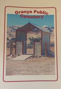 Wodonga & District Historical Society Inc
Booklet - Granya Public Cemetery
This booklet was compiled by the Granya Heritage group. It contains records of people buried at the Granya Public Cemetery between 1880 and 2003. The booklet contains maps of the plots in both the Protestant and Catholic sections of the cemetery. Where available information provided includes Surname, Given Name, Year of Death, Age, Parents , Registration No., Denomination and Cause of Death.A booklet containing a plan of the Granya Public Cemetery and a listing of the people buried there between 1880 and 2003. The cover features a colour photograph of the gateway to the cemetery.non-fictionThis booklet was compiled by the Granya Heritage group. It contains records of people buried at the Granya Public Cemetery between 1880 and 2003. The booklet contains maps of the plots in both the Protestant and Catholic sections of the cemetery. Where available information provided includes Surname, Given Name, Year of Death, Age, Parents , Registration No., Denomination and Cause of Death.granya public cemetery, cemetery records -
 Wodonga & District Historical Society Inc
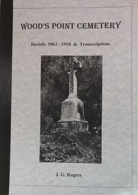
Booklet - Wood's Point Cemetery Records Burials 1863 - 1920 & Transcriptions, Rogers, J. G, 1995
A detailed history of the town of Wood's Point and stories of many of the people buried in the Cemetery. It also contains an analysis of places of origin and a glossary of causes of death. An index and a bibliography are included.A book containing detailed information about the history of Wood's Point, Victoria. It gives detailed information about citizens of Wood's Point buried at the local cemetery. Maps of the area are included.non-fictionA detailed history of the town of Wood's Point and stories of many of the people buried in the Cemetery. It also contains an analysis of places of origin and a glossary of causes of death. An index and a bibliography are included.epitaphs -- victoria -- woods point, cemeteries -- victoria -- woods point, woods point cemetery -
 Wodonga & District Historical Society Inc
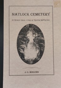
Booklet - Matlock Cemetery Records Burials 1864 - 1946 & Transcriptions, Rogers, J. G, 1999
A detailed history of the town of Matlock and stories of many of the people buried in the town's Cemetery. It also contains an analysis of places of origin and a glossary of causes of death.A book containing information about the history of Matlock, Victoria. Detailed information about citizens of Matlock buried at the local cemetery. Maps of the area are included as well as official government communications related to the establishment of the cemetery. A bibliography and index are also provided.non-fictionA detailed history of the town of Matlock and stories of many of the people buried in the town's Cemetery. It also contains an analysis of places of origin and a glossary of causes of death. matlock cemetery, matlock, small cemeteries victoria -
 Whitehorse Historical Society Inc.
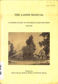
Manual - Government (Lands Dept), Royal Historical Society of Victoria, The Lands Manual - A Finding Guide to Victorian Land Records 1836 - 1983, March 1989
The manual documents the archives of the Department of Crown Lands and Survey (Lands Department) between 1836 to 1983 and explains how they can be used for historical research.The manual documents the archives of the Department of Crown Lands and Survey (Lands Department) and explains how they can be used for historical research.The manual documents the archives of the Department of Crown Lands and Survey (Lands Department) between 1836 to 1983 and explains how they can be used for historical research.crown lands, victoria. department of crown lands and survey -
 Bendigo Historical Society Inc.
Document - SPECIMEN COTTAGE COLLECTION: VARIOUS DOCUMENTS
In 1853, Bendigo Miners protested against the 30 shilling miners licence the had to pay the government. They wore red ribbons to show their protest and shopkeepers hung red ribbons outside their premises in support. Thousands of miners signed a petition to Governor LaTrobe to no avail. A protest gathering in Pall Mall marched to the Government camp on Camp Hill but this was a peaceful event again to no real avail.Various documents. The topics are: 1. Public donations and organised charities in Bendigo (1850's to 1900's by Carol Holsworth. 2. The spirit of Bendigo R711 and the loco driver on the return trip from Bendigo by Rod Giri, also several photographs of the train. 3. Diary of a new chum - Johnny Greenfield Gill. 4. Family history by Pat Hocking. 5. The story of the Gaylards as told by Ella Gaylard. 6. Journalism- History first draft by Wayne Gregson. 7. List of residents of Thistle Street, Bendigo approx. 1950's compiled by Cynthia Stringer. 8. Sandhurst club history by David Cotton. 9. Sandhurst boys centre compiled by Brian Dillon. 10. Lily Street Walk 24/04/2018 notes by Jim Evans. 11. Document - All things Bendigo, wine food and music fest. 12. White Hills Sandhurst copies of maps and two pages of district directory1908. 13. Draft report of interview with Noel Smith of 5 Summit Drive, Kennington. 14. Three brothers from Scotland by Rae Alexander Anderson. Also, seven newspaper articles by James Lerk on William, Alexander Rae and John Rae. 15. St. John Presbyterian church, Bendigo. Historical record. 16. Journal of Thomas Llewellyn Raston. 17. Recollections of Sandhurst in the 1850's - Joseph Anderson Panton, 22 segments from Panton manuscript by Terry Davidson. Also, a photographs of a portrait of Joseph Panton. 18. Photocopy of letter of Chinese storekeepers, miners and residents to Joseph Anderson Panton esquire, resident warden of Bendigo dated August 28th, 1858, with transcription and the reply from Esquire Panton dated 29 August, 1858. 19. View street reborn, tours of inspection ''welcome to View Street'' view Street properties part of stage 1 of the project: National Trust Chambers, Temperance Hall, Art Gallery Annexe, Trades Hall, Bendigo Regional Arts Centre, Bendigo Regional Performing Arts Centre, Dudley House. 20. View Street early 1900's in between and now. From handwritten notes by Mr. Bob Carr written in 1989. The handwriting has been transcribed by Beverly Ellis. 21. Transcription of ''Diary of a voyage to the colony of Victoria and back'' June1856-September 1858 by Charles Groves. 22. Adelaide Vale historic homestead built by Cr. John Harney. Tour notes prepared by the Central Victorian Branch of the National Trust. 23. Four pages essay titled Spanish Tomato Growers. 24. Eight pages of notes compiled by Leonard Henderson title: Trade token issuers of Bendigo district. The issuers mentioned are: Grieve, Hodgson, Stead and Williams. 25. City of Bendigo tourist promotion Committee. Eight pages document describing the formation of committee for the promotion of tourism in the City of Bendigo. 26. Article ''The Birdman of Bendigo'' Bendigo Advertiser 17th January 1968 detailing the life of Mr. Redvers James Eddy. 27. Speech presented by Miss Margaret Brennan on the occasion of the Drechsler family reunion, Sunday 5th April 1987. 28. Robert Gray Ford - A man before his time! Talk by James Lerk to the Bendigo Historical Society 3 February 2006. 29. Copy of an article from The Bendigonian Annual from November 16, 1910. The demand for good music, how a Bendigo firm has met it. The article is about the life of Oscar Flight. 30. Five photocopies of the Bendigonian masthead showing the changes through the years, plus the notice of the final issue on April 8th, 1920. 31. The red ribbon rebellion & the Bendigo petition, a proposal to commemorate a significant event in Bendigo. Also three different sizes poster for the August 26, 2016 re-enactment and two invitations to join the red ribbon agitation memorial. 32. Two handwritten pages of notes on the red ribbon rebellion. 33. Three pages of typewritten notes on the Creeth and Howie families. 34. An Australian Edward Medallist - Joseph Davies honoured by Paul Street. 35. A. H. Chisholm obituary. 36. Catalogue auction sale of the entire collection of antique furniture, objects d'art etc of Mr. and Mrs S. Cragg. 37. two coloured photographs of Cherry Tree Hotel in Melbourne Road just north of Tuckerman's lane, Big Hill. Photos taken March 2000 by Joan Paynter. -
 Bendigo Military Museum
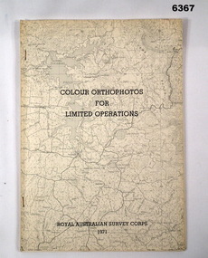
Administrative record - Royal Australian Survey Corps - Colour Orthophotos for Limited Operations 1971, Army Survey Regiment, Bendigo, 1971
This is a report on the experimental production of the colour Orthophoto Map 1:25,000 7924 - 3 - SW Northwood (Puckapunyal area) during 1971 conducted at the Army Survey Regiment Bendigo. The report covers all aspects of production including cartographic enhancement, test proofing, platemaking and printing. While Annexes A and C are listed in the contents, they are missing from the document. A second copy has been added to this record that contains Annex A that is a colour enhanced colour orthohotomap of the map sheet.Soft covered A4 sized booklet stapled along the left hand side. Title and a greyed map image printed on cover. A second copy containing Annex A was added in 2025royal australian survey corps, rasvy, fortuna, army survey regiment, army svy regt, asr -
 Falls Creek Historical Society
Document - Bob Hymans' Correspondence Collection
Bob (Herman) Hymans (a former member of the Royal Netherlands Navy) was born in Bloemendaal, Holland on 30th September 1922. During World War II he fought against the Japanese in the Dutch East Indies (now Indonesia) and was imprisoned in Changi and on the Burma Railway. After gaining qualifications as a Ski Instructor, Bob arrived in Falls Creek in July 1950. Working as an Instructor and Supervisor at Bogong Lodge, Bob decided his future was in accommodation. He was successful in negotiating an indenture for land from the State Electricity Commission (SEC). It took Bob two years to build his Grand Coeur Chalet but, tragically, it was burned down in August 1961. Bob also built the first Chairlift in Australia. This was a single chairlift and the structure was built from wooden electricity poles. He was constantly full of new ideas and proposals for the village. Bob Hymans died on 7th July 2007. This collection of between 200 - 300 items includes documents from Bob Hymans' correspondence whilst he was pioneering developments at Falls Creek, Victoria. It consists of Aerogrammes, telegrams, maps and communication with American and French companies related to issues ranging from licences, ski tows, international visits and developments at Falls Creek.This Collection is significant because it contains correspondence records of a Falls Creek pioneer who played an active role in the development of Falls Creek Village, including the first ski lift as well as Grand Coeur and Four Seasons lodges.A collection of letters and other documents from the personal records of Bob Hymansbob hymans, falls creek pioneers -
 Warrnambool and District Historical Society Inc.
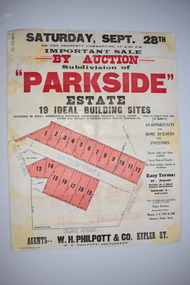
Work on paper - Original Document, H J Paynter, Advertisement "Parkside"Estate subdivision, Circa 1935
This sheet denotes an auction of land which is situated close to Albert Park on the northern part of Warrnambool. The area is complete now with homes which are a mixture of brick and concrete faced houses. The agent W H Philpott was operating in Warrnambool from the 1930's though to 1950'sThis item has local interest and significance as it records the sale of Warrnambool land.Large white paper sheet with black and red text. The auction details are at the top and down the righthand side with a map of the available blocks are coloured red and outlined in black.Parkside estate, W H Philpott & Co Kepler St , R V Philpott auctioneer,Solicitors J S Tait & son. Cramer Street, Nelson Street McConnell Street.warrnambool, mcconnell street warrnambool -
 Melbourne Tram Museum
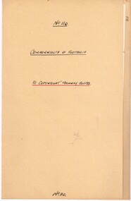
Legal record, Commonwealth of Australia - Copyright Office, "Commonwealth of Australia - Re copyright Tramway Routes", 8/12/1925 12:00:00 AM
Legal document within a light brown manila document - titled "Commonwealth of Australia - Re copyright Tramway Routes". Typed on pre-printed paper, Copyright Office, No. 14428, registering the MMTB as the copyright owner in a literary work, a map, entitled "Melbourne's Tramway Routes and Time Tables". Dated 8-12-1925, with date stamp of 22/12/1925 as being received by the Board. Address to A. S. Whyte of the Board. Folder has file number "110" written on the outside.trams, tramways, mmtb, commonwealth government, legal agreements, copyright, maps -
 Melbourne Tram Museum
Document - report, Norm Wadeson, "Sorrento Tramway", 1961
Notes prepared by Norm Wadeson 1961 from Lands Department Records about the history of the Sorrento Tramway. Has notes on the formation, operation, passengers carried, land, possible extension, deputations to the Minister, Mr George Copin, and closure. See item 7717 for maps and photographs.Yields information about the Sorrento tramway co. and its Lands Department records.Two quarto sheets, typed - stapled in top left hand corner.tramways, tramcars, sorrento, george coppin -
 Bendigo Military Museum
Administrative record - Royal Australian Survey Corps Planning Conference 1972 - Standard of Compilation sheets by Army Survey Regiment, Army Survey Regiment, Bendigo, 03.10.1972
This booklet was prepared for the Royal Australian Survey Corps Planning Conference 1972 by the Army Survey Regiment held at Fortuna Bendigo. It was intended to provide a trouble shooting guide for personnel engaged in the production of map compilation sheets. See also item Number 6517 "Standard of Compilation Sheets" by LtCol DR Ridge (RASvy)26 x A4 page document containing typed text diagrams and copied map extracts, photocopies and Oza film. Item is four hole puched and is held together by an ARNOS Fastenerroyal australian survey corps, rasvy, fortuna, army survey regiment, army svy regt, asr -
 Bendigo Historical Society Inc.
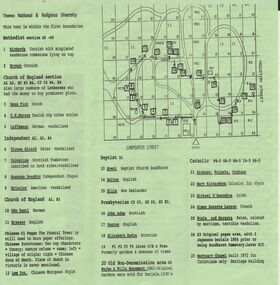
Document - BENDIGO CEMETERIES COLLECTION: SELF GUIDED TOUR NO. 4 DOCUMENT
BHS CollectionGreen trifold document: Self Guided Tour No. 4 of the Bendigo Cemetery, Friends of the Bendigo Cemeteries 1997. Map of Bendigo Cemetery with numbered grave sites. Theme : National and religious diversity. Text on back describes how early colonists arrived with different religions, languages, social habits etc Sandhurst Cemetery Register recorded denomination not nationality, but noted if the dead person was coloured.Friends of the Bendigo Cemeteries Inc 1997bendigo, cemetery, bendigo cemetery tour -
 Bendigo Military Museum
Administrative record - International Map of the World (IMW) 1:1 Million Scale - H Ureta, Circa 1964, MR H Ereta, Post 1964
This document records the history of the International Map of the World (IMW) at 1:1Million Scale. Mr H. Ereta, Chief of the Cartographic Section of the United Nations Department of Economic Development and Social Affairs gave a lecture on the IMW and described the history and development of the map series in post 1964. This document is a copy of that lecture. 7 x Foolscap pages of typed text, stapled and two hole punched, Paper is dis-coloured.royal australian survey corps, rasvy, fortuna, army survey regiment, army svy regt, asr, imw -
 Bendigo Military Museum
Administrative record - Royal Australian Survey Corps - A simple silk screen equipment for limited map reproduction by LTCOL HM Hall (RASvy) 1967, LtCol HM Hall (RASvy), 6 Feb 1967
This paper deals with the employment of Hand operated Mobile Screen Printing Equipment and its associated cartographic techniques for limited map reproduction and overprinting under field conditions. Written by LtCol HM Hall (RASvy)8 x A4 page document containing typed text, photos and map extractroyal australian survey corps, rasvy, fortuna, army survey regiment, army svy regt, asr, school of military survey, sms -
Whitehorse Historical Society Inc.
Document - Report, Robert Bethel, 1/06/1997
Photocopy of school assignments. Includes description of several local war memorials and an investigation into the record of Robert Bethel whose name appears on the Box Hill and Mitcham War Memorials although he was a Tasmanian. Bethel was killed at Gallipoli, information includes copies of Bethel's military record and correspondence with his parents, his family background and details of his brother, Wilfred Michael Bethel also killed in action at the Somme. Maps show his travels. Illustrations. Approx 42 pagesbethel, robert, world war, 1914-1918. battle of gallipoli, wilfred michael, world war 1914-1918. battle of the somme, war memorials -
Ballarat Tramway Museum
Administrative record, State Electricity Commission of Victoria (SECV), "Queen Mother's visit - Tramway Arrangements", March 1958
... Mother Begonia Festival Royal Visit Map Administrative record ...Set of documents regarding the visit of the Queen Mother to Ballarat for the Begonia Festival on 2 March 1958. Comprises: 1 - SEC tramway arrangements - giving tramcar termination and restarting while the visit occurred 2 - Multiple copies of the Begonia Festival programme and the Music for the People event 3 - Letter from D I Graham thanking all those involved on Begonia Festival letterhead dated 7/4/1958 4 - Greater Ballarat map - with tram notes along the top edge. 5 - three page handwritten notes regarding tram arrangements, inspectors, and other notes.Yields information about the 1958 visit by the Queen Mother.Administrative record or documents - 8 sheets, and one folded map.tramways, queen mother, begonia festival, royal visit, map -
 Ballarat Tramway Museum
Administrative record - Book, Andersons' printing, "Ballaarat Tramways", Jan. 1888
Book with an index or table of contents, listing all the documents relating to the establishment of the Ballaarat Tramways (the horse tram operator) including, references to Legislation and orders in council, original tender conditions, the contract between the Council and Edward Thomson, Specifications for the construction, delegation to the operator, and plan of routes. Last document dated 17/1/1888.Yields information about the establishment of the Ballarat horse trams, Councils and the operator.Bound book, with end papers, 20 pages, patterned covers, titled with a label on the front cover - "Ballaarat Tramways"Has an old ownership note on the inside front cover.secv, tramways, horse trams, city of ballaarat, ballaarat tramway company, tenders, specifications, operations, maps -
 Bendigo Historical Society Inc.
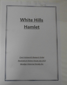
Document - RESEARCH FOLDER COLLECTION: WHITE HILLS HAMLET, 1990 - 2015
... rolls, local directories, and rates records Maps Document ...Folder of research material compiled by Carol Holsworth. Received at History House in July 2023. White Hills Hamlet Includes Newspaper articles including many photographs of properties in the White Hills area advertised for sale Historical information about White Hills Hamlet properties Family history information about former residents of the White Hills area Notes based on electoral rolls, local directories, and rates records MapsCarol Holsworthbendigo, history, white hills hamlet