Showing 169 items
matching early sunbury
-
 Hume City Civic Collection
Photograph, Early 1970s
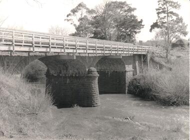
The Macedon Street Bridge over Jacksons Creek is important because it was built on one of Victoria's first important roads. It replaced a smaller lighter bridge in 1857 and continued to be used until the early 1970s.A black and white photograph of a two arched bluestone bridge over a creek. A wooden post and rail fence painted white has been constructed in front of the original stone wall of the bridge.bridges, bluestone bridges, jacksons creek, macedon street, george evans collection -
 Hume City Civic Collection
Photograph, 1960s
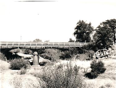
The two-arched bluestone bridge which spans the Jacksons Creek at the east end of Sunbury township, was built in 1857 and continued to be used as a road bridge on the main Sunbury Road-Macedon Street until the early 1970s when a wider bridge replaced the original bluestone bridge.A black and white photograph of a two- arched bluestone bridge which spans a dry creek bed. A bulldozer is on the riverbank on the RHS of the photograph.bridges, bluestone bridges, jacksons creek, harris, thomas lascelles, macedon street, george evans collection -
 Hume City Civic Collection
Photograph, Early 1970s
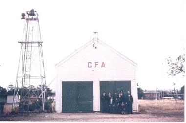
The old Sunbury CFA station was situated in Evans Street where part of the Sunbury Shopping Square has been built. It was opened on that site in 1914. In 1969 a newer fire station was built in Evans Street on the opposite side of the road and closer to Macedon Street. From 1969 until 1978 the old fire station became a scout hall. In the early 2000s two new fire stations were built away from the main shopping area. One was built in Jackson Street, opposite the Ball Court Hotel and the other one was built on the corner of Gap Road and Elizabeth Drive. By locating them out of the immediate shopping centre which had become quite busy, it meant that access in and out of the new stations was quicker. The butter factory in Horne Street is on the RHS and the former public tennis courts are on the LHS of the photograph.A coloured photograph of the CFA firemen standing outside the former CFA building. The bell tower is on the LHS of the building.country fire authority, fire fighters, sunbury fire station, butter factory, tennis courts, george evans collection -
 Hume City Civic Collection
Photograph
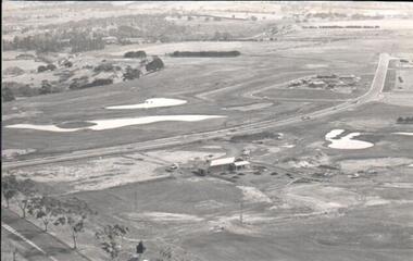
A black and white aerial photograph of an aerial view of the newly established Goonawarra Golf Club. Sunbury Road is visible in the bottom LH corner and Francis Avenue crosses the photograph. The clubhouse is in the centre of the photograph and some early housing development is in the distance.goonawarra gold club, housing developments, regional newspaper, george evans collection -
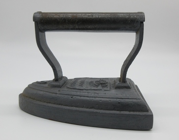
 Hume City Civic Collection
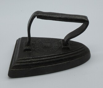
Domestic object - Flat Iron
These small heavy flat irons were used to iron clothes prior to electric irons being invented. They were heated on a wood fire stove top and used quickly before they lost heat to iron items of clothing and other small items. These irons were very heavy so that they retained the heat when heated by a wood fire stove top prior to electricity being connected to houses. Flat irons were used in the 1800's and in the early 1900's.Heavy black small flat iron with handle on top. Iron tapers from flat wide base to rounded point. It has a round logo on front under the handle.Unreadable round possibly manufacturers logo.social history, irons, ironing, domestic items, 1800's -
 Hume City Civic Collection
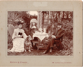
Photograph, c1907
... Church of England in Sunbury during the early decade... Church of England in Sunbury during the early decade ...The Rev. Charles Edward Gayer was the vicar at St. Mary's Church of England in Sunbury during the early decade of the twentieth century.A sepia coloured photo of the Rev and Mrs Gayer with their daughter, Crystal, in a garden setting with an afternoon tea set up. The photo is mounted on a grey cardboard mat. There are a number of stains and some foxing on it and also a number of pin holes and an area of superficial paper loss centre top of the mat.Matson and Frazer 264 Collins Streetgayer, rev charles edward, - (mrs), george evans collection -
 Hume City Civic Collection
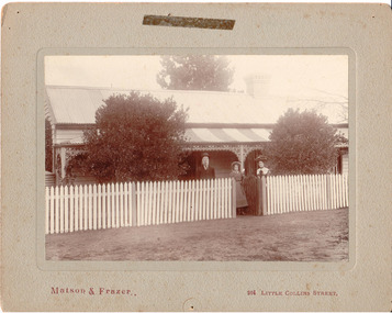
Photograph, c1907
Members of the Fanning family standing outside their house 'Sunnyside', in Loemans Road, Bulla. The Fannings were one of the early European families to settle in the Bulla township. A black and white mounted photograph of the Fanning family in front of a cottage with a picket fence.Printed on face: Matson and Frazer / 264 Little Collins Street Handwritten on back: Eric Boardmanmatson and frazer, photographers, eric boardman collection, fanning family, george evans collection -
 Hume City Civic Collection
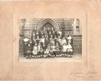
Photograph, 1920
A group of school children and 2 nuns with the Catholic church in the background.Written on front: Catholic school early 1920nuns, catholic schools, schools, 1920s, george evans collection -
 Hume City Civic Collection
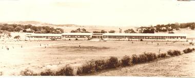
Photograph, c1965
Photo was taken in the early 1960s when the school was first established.Sepia portrait of the original Sunbury Secondary College building. Photograph is unframed and unmounted.Stamped indentation on back: 'C-AUS' and 'S' in pencil handwritten.sunbury secondary college, schools, kismet park, education department, parks and reserves, george evans collection -
 Hume City Civic Collection
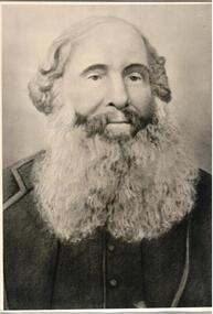
Photograph
A photo of Martin Batey, an early settler in the district.A black and white photo of a male with a full bears and long hair on side, appears to be thinning on top of head. Believed to be Martin Batey. It is mounted between paper and cardboard and transparent paper at front of photo.Written inside cover: Martin Bateybatey, martin, pioneers, george evans collection -
 Hume City Civic Collection
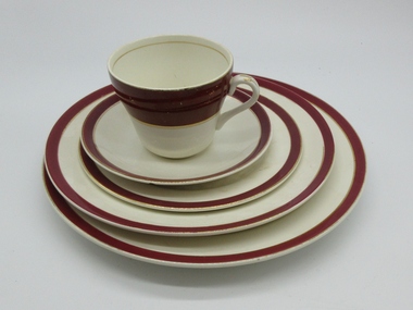
Cup, saucer and plate setting
This was an early table setting used by the Shire of Bulla.A maroon and gold table setting consisting of a cup 271.1 a band of maroon around top of cup with two lines of gold in middle of cup and one line of gold on lip and inside of cup. 271.2 maroon and gold around saucer. 271.3 maroon and gold around the edge of saucerQueens Maroon "Solian ware"shire of bulla, crockery, simpsons, potters, containers, domestic items, george evans collection -
 Hume City Civic Collection
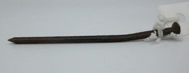
Equipment - nail (building)
An unusual square nail used for building. early 19th Century?A long square nail with a point at one end and a flat head at the other.buildings, building materials, nails, george evans collection -
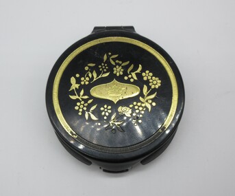 Hume City Civic Collection
Accessory - Powder compact, Angel Face
Compacts containing face powder and foundation in one were sold in department stores from the early 1950's. Their widespread use meant that the heavier powder compacts with face powder were less popular.A round black plastic compact with a gold design on the hinged lid. There is a gold border around the circumference and part of the paint has disappeared near the catch. In the centre there is a coronet which is surrounded with a floral design. Manufacturer's details are stuck on the back of the compact. There is a mirror inside the compact with a small powder puff.CHESEBROUGH PONDS PTY. LTD REG. USER / ANGEL / FACE / by PONDS / BRONZEcosmetics, angel face, face powder, personal effects, chesebrough ponds, george evans collection -
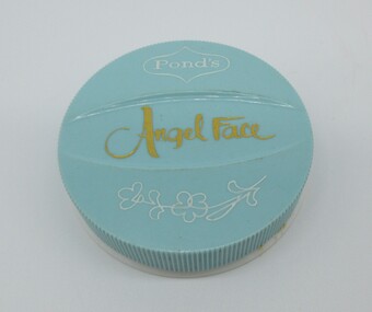 Hume City Civic Collection
Accessory - Powder compact, Angel Face
... Hume City Civic Collection 40 Macedon Street Sunbury ...From the early 1950's compacts containing face powder and foundation in-one were sold in department stores. Their widespread use resulted in heavier compacts and conventional face powder becoming less popular.A round blue plastic powder compact with the captions and design done in gold and blue on lid. The compact contains face powder and foundation in-one and there is a small flatened foam powder puff and information sheet inside.PONDS / ANGEL FACEchesbrough ponds, angel face, cosmetics, face powder, personal effects, george evans collection -
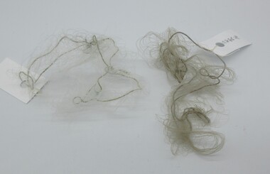 Hume City Civic Collection
Headwear - Hair nets
Hair nets were used to hold unmanageable hair in place. Earlier nets were made from fine natural yarn but nylon replaced the natural fibres in latter years.2 hair nets in different shades of grey inside a small white paper bag.hair accessories, hair nets, personal effects, george evans collection -
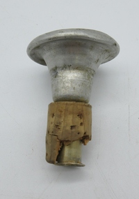 Hume City Civic Collection
Domestic object - Damping bottle with top, Schweppes
The damping bottle was filled with water and used to moisten starched clothes and linen before garments were ironed. The introduction of steam irons into households in the early 1960's resulted in damping bottles becoming superfluous.A glass 'Schweppes' bottle has yellow and black graphics on it. It has been recycled and used as a damping bottle. The metal stopper has been inserted into a cork. There are spray holes on the top of the stopper. The word 'Schweppes' has been embossed around the base of the bottom.13 FL. OZ / SCHWEPPESlaundering, ironing, starching, schweppes, domestic items, george evans collection -
 Hume City Civic Collection
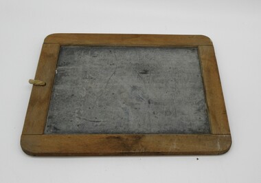
Functional object - Writing slate
Slates were used in the junior grades at primary school probably from the 1900's to the early 1940's. The children wrote on the slate with a special slate pencil. A small slate framed with wood and a piece of string through a hole at the top and knotted.school, education, teaching, writing, george evans collection -
 Hume City Civic Collection
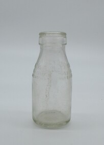
Container - Milk bottle
This object was used to distribute free milk to primary school children during the early 1950's. This distribution of milk was a means of ensuring the children had some way of obtaining milk. Each bottle held 1/3 of a pint of milk.A small glass bottle used to hold a third of a pint of milk.on shoulder "THIRD PINT MILK..."schools, education department, george evans collection -
 Hume City Civic Collection
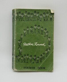
Book, Gather Round/Fourth Book
This green cloth bound book was used as a fourth grade reader in primary schools from 1965. It was a revised edition of earlier reader.A green cloth bound book used as a fourth grade reader."Gather Round..."education department, schools, george evans collection -
 Hume City Civic Collection
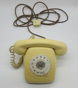
Telephone, Telecom Aust.STC
The cream plastic telephones replaced the black telephones of a similar design in the early 1980's. They were used throughout Australia until the mid 1990's when the wall units and touch phones were introduced.A plastic cream telephone with a dial and receiver which sits on top of the unit. The telephone unit has a fawn cord with a plug which is fitted into the wall."TELECOM AUST..."telecom, telstra, george evans collection -
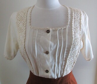 Hume City Civic Collection
Blouse, c.1970's
The blouse made from a man-made fibre which resembled linen and trimmed with crochet motifs and edging was fashionable during the early 1970's. They were often worn with batik printed skirts.A cream linen blouse with three pin tucks and a crochet band on either side of the centre front opening. There is a shell pattern crochet border around the square neckline and across the hem of the short sleeves and around the bottom of the blouse. There are two darts in the back. there are five brown buttons down the centre front."Made in the/PHILIPPINES/..."1970s, clothing and dress, george evans collection -
 Hume City Civic Collection
Domestic object - Flat Iron
This iron is from Bayview Farm, Diggers Rest and believed to have been used there.Flat based irons were used to iron clothes and other items prior to electric irons being invented and electricity being connected to houses. They were used mainly in the 1800's and early 1900's.Heavy flat based iron with handle. Inscriptions on front, tapers from wide back to rounded point at front.on point of iron "6" on front "SILVESTER'S/PATENT..."cullinan, c, diggers rest, george evans collection -
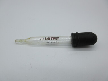 Hume City Civic Collection
Eye Dropper
... as Caloola closed down in the early 1990's. sunbury sunbury asylum ...The measuring instruments which were used in the Pharmacy Department at the Sunbury Asylum were collected by a former Curator of the GEM and members of the GEM before the Asylum also known as Caloola closed down in the early 1990's.A small eye dropper with a black cap at the top."CLINTEST"sunbury, sunbury asylum, george evans collection -
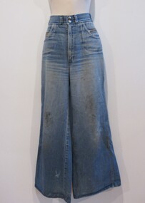 Hume City Civic Collection
Jeans
... Thought to have been worn at Sunbury Pop Festival early... melbourne Thought to have been worn at Sunbury Pop Festival early ...Thought to have been worn at Sunbury Pop Festival early 1970's held on George Duncan's property.Blue denim mens jeans, two silver studs on waist band. Two zipper pockets front and back. Wide bottom flares.on label on waist band "Staggers/RegdTM..."sunbury pop festival, clothing and dress, george evans collection -
 Hume City Civic Collection
Equipment - Seal Press
This heavy seal press would have been used to emboss impressions of the Shire of Bulla seal onto documents. This seal impressed "The President Councillors and Citizens of The Shire of Bulla" plus a central emboss and would have been used sometime between 1866-1989. Various Councils within Victoria amalgamated in the early 1990's. The Shire of Bulla amalgamated and became part of the City of Hume.A large heavy shiny black seal press.council seals, seals, shire of bulla, bulla shire council -
Hume City Civic Collection
Equipment - Seal Press
This heavy seaal press would have been used to emboss impressions of the Shire of Bulla seal onto documents. This seal impressed "The Mayor, Councillors And Citiizens of the Shire of Bulla" and was used between 1989-1994. Various Councils within Victoria amalgamated in the early 1990's with the Shire of Bulla becoming part of the City of Hume.A large heavy dull black seal press.council seals, seals, shire of bulla, bulla shire council -
Hume City Civic Collection
Plaque - Shire of Bulla Plaque
This round Shire of Bulla plaque would have been attached possibly to a lectern by three screws as per the back of the the plaque. Shire of Bulla amalgamated to become part of the City of Hume in 1994. Various council areas in Victoria amalgamated in the early 1990's.A heavy round brown and gold colour plaque.The President Councillors And Ratepayers of the Shire of Bulla 1866shire of bulla, plaques, local government -
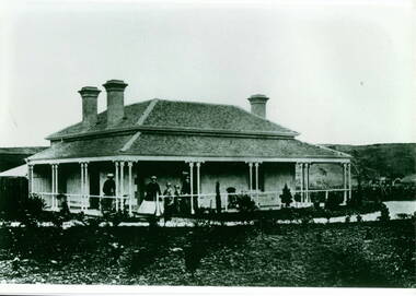 Hume City Civic Collection
Photograph, Craiglee Homestead
The property is Craiglee, which was one of the first vineyards established in Sunbury in 1865 by Stuart Johnson. It is sited on the east bank of Jackson Creek and fronts onto Macedon Street. Goonawarra is another early vineyard on the opposite side of Macedon Street.A black and white photograph of a Victorian single storey homestead with a return verandah. Five people are standing on the porch. There are hills across the skyline and the garden surrounds the house.craiglee, johnson james stuart, vineyards, ] -
Hume City Civic Collection
Sticker, Shire of Bulla
This adhesive sticker with Shire of Bulla Sunbury printed on it along with City Living/Country Style a slogan used by the Shire in the 1980's to early 1990's. They were used to stick on any type of flat surface to help promote the area within the Shire of Bulla especially Sunbury.This is a rectangle shape adhesive sticker promoting the Shire of Bulla.Shire of Bulla/City Living/Country Styleshire of bulla, councils, advertising -
Hume City Civic Collection
Advertisement
... . Edwards in the late 1940's early 1950's Sunbury Garages Brook ...This is a photocopy of an advertisement of the Sunbury Garage that was situated on the corner of Brook Street and O'Shanassy Street. It was run by Harry Muir and his partner Mr. Edwards in the late 1940's early 1950'sThis is a photocopy of an advertisement for a local garage.sunbury, garages, brook street, o'shanassy street, muir harry