Showing 1087 items matching "earth"
-
 Ballarat Heritage Services
Photograph - Colour, Earth Banks, Old Sarum, England, 2016, 01 November 2016
William the Conqueror inherited Old Sarum from the last Saxon king of England. It was an ideal site for a royal castle. It was here in 1070 that William paid off his army after a long and bitter campaign in northern England. It was here in 1086 that he called together all the major landholders in England so they could swear allegiance to him. It was a crucial moment. The Domesday Book was being written, a threatened Viking invasion had only just been averted and William's eldest son was in armed rebellion. Old Sarum was an important place where this Norman king of England held power. In 1794 the Ordnance Survey set out to check the accuracy of the first mapping of Southern England, which had begun ten years earlier. From a point just below Old Sarum Lieutenant William Mudge laid out a base-line 36,574 feet (11,253 metres) long. From each end of the line the positions of distant places were plotted using a huge theodolite made in 1791 by Jesse Ramsden. The accuracy of the process, which was repeated all over England, depended on Jesse Ramsden's craftsmanship and on William Mudge's surveying skill in setting out this first base-line from Old Sarum. The nearer end of Mudge's line is marked by an inscribed stone beside the modern A345 at Old Sarum. ordnance survey, william mudge, jesse ramsden, william the conqueror, old sarum, saxon, 1086, england -
 Ballarat Heritage Services
Photograph - Colour, looking from Stonework towards earth mounds, Old Sarum, England, English Heritage Site, 2016, 01 November 2016
William the Conqueror inherited Old Sarum from the last Saxon king of England. It was an ideal site for a royal castle. It was here in 1070 that William paid off his army after a long and bitter campaign in northern England. It was here in 1086 that he called together all the major landholders in England so they could swear allegiance to him. It was a crucial moment. The Domesday Book was being written, a threatened Viking invasion had only just been averted and William's eldest son was in armed rebellion. Old Sarum was an important place where this Norman king of England held power. In 1794 the Ordnance Survey set out to check the accuracy of the first mapping of Southern England, which had begun ten years earlier. From a point just below Old Sarum Lieutenant William Mudge laid out a base-line 36,574 feet (11,253 metres) long. From each end of the line the positions of distant places were plotted using a huge theodolite made in 1791 by Jesse Ramsden. The accuracy of the process, which was repeated all over England, depended on Jesse Ramsden's craftsmanship and on William Mudge's surveying skill in setting out this first base-line from Old Sarum. The nearer end of Mudge's line is marked by an inscribed stone beside the modern A345 at Old Sarum. ordnance survey, william mudge, jesse ramsden, william the conqueror, old sarum, saxon, 1086, england -
 Ballarat Heritage Services
Photograph - Colour, Looking from Stonework towards people walking on earth mounds, Old Sarum, England, English Heritage Site, 2016, 01 November 2016
William the Conqueror inherited Old Sarum from the last Saxon king of England. It was an ideal site for a royal castle. It was here in 1070 that William paid off his army after a long and bitter campaign in northern England. It was here in 1086 that he called together all the major landholders in England so they could swear allegiance to him. It was a crucial moment. The Domesday Book was being written, a threatened Viking invasion had only just been averted and William's eldest son was in armed rebellion. Old Sarum was an important place where this Norman king of England held power. In 1794 the Ordnance Survey set out to check the accuracy of the first mapping of Southern England, which had begun ten years earlier. From a point just below Old Sarum Lieutenant William Mudge laid out a base-line 36,574 feet (11,253 metres) long. From each end of the line the positions of distant places were plotted using a huge theodolite made in 1791 by Jesse Ramsden. The accuracy of the process, which was repeated all over England, depended on Jesse Ramsden's craftsmanship and on William Mudge's surveying skill in setting out this first base-line from Old Sarum. The nearer end of Mudge's line is marked by an inscribed stone beside the modern A345 at Old Sarum. ordnance survey, william mudge, jesse ramsden, william the conqueror, old sarum, saxon, 1086, england -
 Ballarat Heritage Services
Photograph - Colour, Public toilets hidden in earth mound, Old Sarum, England, English Heritage Site, 2016, 01 November 2016
William the Conqueror inherited Old Sarum from the last Saxon king of England. It was an ideal site for a royal castle. It was here in 1070 that William paid off his army after a long and bitter campaign in northern England. It was here in 1086 that he called together all the major landholders in England so they could swear allegiance to him. It was a crucial moment. The Domesday Book was being written, a threatened Viking invasion had only just been averted and William's eldest son was in armed rebellion. Old Sarum was an important place where this Norman king of England held power. In 1794 the Ordnance Survey set out to check the accuracy of the first mapping of Southern England, which had begun ten years earlier. From a point just below Old Sarum Lieutenant William Mudge laid out a base-line 36,574 feet (11,253 metres) long. From each end of the line the positions of distant places were plotted using a huge theodolite made in 1791 by Jesse Ramsden. The accuracy of the process, which was repeated all over England, depended on Jesse Ramsden's craftsmanship and on William Mudge's surveying skill in setting out this first base-line from Old Sarum. The nearer end of Mudge's line is marked by an inscribed stone beside the modern A345 at Old Sarum. ordnance survey, william mudge, jesse ramsden, william the conqueror, old sarum, saxon, 1086, england -
 Ballarat Heritage Services
Photograph - Colour, Entrance to Public toilets hidden in earth mound, Old Sarum, England, English Heritage Site, 2016, 01 November 2016
William the Conqueror inherited Old Sarum from the last Saxon king of England. It was an ideal site for a royal castle. It was here in 1070 that William paid off his army after a long and bitter campaign in northern England. It was here in 1086 that he called together all the major landholders in England so they could swear allegiance to him. It was a crucial moment. The Domesday Book was being written, a threatened Viking invasion had only just been averted and William's eldest son was in armed rebellion. Old Sarum was an important place where this Norman king of England held power. In 1794 the Ordnance Survey set out to check the accuracy of the first mapping of Southern England, which had begun ten years earlier. From a point just below Old Sarum Lieutenant William Mudge laid out a base-line 36,574 feet (11,253 metres) long. From each end of the line the positions of distant places were plotted using a huge theodolite made in 1791 by Jesse Ramsden. The accuracy of the process, which was repeated all over England, depended on Jesse Ramsden's craftsmanship and on William Mudge's surveying skill in setting out this first base-line from Old Sarum. The nearer end of Mudge's line is marked by an inscribed stone beside the modern A345 at Old Sarum. ordnance survey, william mudge, jesse ramsden, william the conqueror, old sarum, saxon, 1086, england -
 Moorabbin Air Museum
Book (Item) - Textbook Of Air Armament Part 1 , Chapter 5 Craters And Earth Movements
-
Moorabbin Air Museum
Plaque (Item) - And of the living ... not one who truly loves the sky would trade a hundred earth bound hours for one that he could fly Gill Robb Wilson
-
 Federation University Art Collection
Ceramic - Ceramic - hand built & coloured porcelain, Lo, Li Feng, 'Natural Series (Earth, Sky, Water)', by Li-Feng Lo, 2010
My work is informed by a philosophical and spiritual engagement with Buddhist ideas, particularly in response to environmental concerns. In this work I wanted to challenge myself and explore the limits of clay material. Clay allowed me to express myself and free my mind. When I revisited Australia in 2010 form my residency, the natural environment here still was the best to me. Li-Feng LO (1967- ) Born Taiwan Ceramic artist Dr Li-Feng Lo completed a PhD at Monash University in 2008. She was a resident artist in the Federation University Arts Academy ceramics studio in 2010. Li-Feng worked with Southern Ice porcelain to create sculptural forms in response to environmental concerns. Her work is informed by a philosophical and spiritual engagement with Buddhist ideas. These works were exhibited in the exhibition 'AIRed' at the Post Office Gallery in 2011. This was a group exhibition showcasing the work of six artists who undertook residencies at the Arts Academy over a couple of years. This item is part of the Federation University Art Collection. The Art Collection features over 1000 works and was listed as a 'Ballarat Treasure' in 2007.Handbuilt (pinched), coloured porcelain form. Artist's Statement: In the beginning I try to use clay to achieve a dream-like quality by providing a feeling of flexibility like paper and fragility like glass. I was my artwork to the one with nature. Gift of the artist, 2010art, artwork, li-feng lo, ceramics, artist in residence, available, available ceramics, chinese -
 Federation University Art Collection
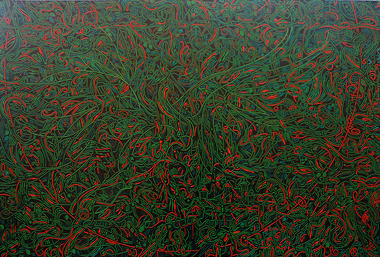
Painting - Artwork, 'Earth Trailings' by Peter Storey
This item is part of the Federation University Art Collection. The Art Collection features over 2000 works and was listed as a 'Ballarat Treasure' in 2007.Black abstract painting blue, yellow and red curvie lines.art, artwork, peter storey, abstract, business school collection -
Federation University Art Collection
Printmaking - Etching, Evans, Mel, Leap of Earth
This item is part of the Federation University Art Collection. The Art Collection features over 1000 works and was listed as a 'Ballarat Treasure' in 2007.art, artwork -
Federation University Art Collection
Work on paper - Artwork - Printmaking, Tiana Price, 'Earth' by Tiana Price
tiana price, printmaking -
Kadimah Jewish Cultural Centre and National Library
Programme, Our Earth; 1951
Play in 3 acts directed by Jacob Waislitz. Choreographed by Ruth Bergner. Piano M. Rochlin and Violin Sh. Newmandovid herman theatre, jacob waislitz, leah zuker, sh. tigel, rochel lewita, moshe berinson, mordechai rotfarb, avrom pat, j. blustein, f. mrocki, zvi gershov, stella brustman, yasha sher, meyer ceprow, j. levine, israel rothman, s. hochgelernter -
University of Melbourne, Burnley Campus Archives
Newspaper - Newspaper Cutting, The Sun, Down-to-earth-scientists, 1969
Newspaper cutting from The Sun, September 18, 1969, p. 29. Includes photos of some young women with a tractor and feeding cows in a country setting, and of Mr Farrance (staff, 1952-1975). Article by John Farrance and Ian Anderson which discusses the range of educational possibilities for school leavers interested in Agriculture. Includes information about Melbourne University, LaTrobe University, Dookie, Longerenong and Burnley. Discusses possible employment for graduates and the cost of education at the colleges.the sun, john farrance, ian anderson, agricultural schools, girls education, agriculture, employment -
 Federation University Historical Collection
Book, Geological Gossip or Stray Chapters on Earth and Ocean, 1860, 1860
Brown hard covered book. Chapter 16 is on gold deposits and discusses the discovery of gold in California and Australia.Brown hard covered book geology, water, rivers, the atlantic, great deep, africa, australian interior, eyre's expedition, murray river, darling river, earthqaukes, leichardt, moreton bay, volcanos, darwin's theory, evolution, egyptian race, human remains in caverns and gravel, rocks, metamorphism, iron ores, coal, coal fields, gold deposits, california, water-glass, artificial stone, porous stones, cements -
 Darebin Art Collection
Painting, Caesar Sario, Sienna Earth, 2013
painting -
Lakes Entrance Historical Society
Book, Earth and Industry - Stories from Gippsland, 1984
This collection explores the theme of the regions environmental history and how societies perceived it.history -
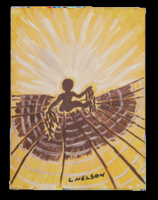 Darebin Art Collection
Painting, Lorraine Nelson, The Baby is Feeling Mother Earth, 2004
-
Moorabbin Air Museum
Book - BETWEEN EARTH AND SKY, AUGUSTE PICCARD, 1950
-
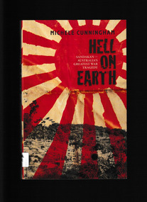 Monbulk RSL Sub Branch
Book, Michele Cunningham, Hell on Earth : Sandakan - Australia's greatest war tragedy, 2103
The heart-rending story of the Australians brutally imprisoned in Sandakan, the Japanese POW camp in North Borneo, whose very name came to symbolise cruelty and ill-treatment. In mid-1942, after the fall of Singapore, almost three thousand Allied prisoners of war were taken by the Japanese from Changi to Sandakan. Of those, 2500 lost their lives. Men died at Sandakan and on the infamous death marches: they died from sickness and starvation, torture and appalling violence, or were killed by the guards as they were forced to keep moving along a seemingly never-ending track. Only six Australians survived the death marches, out of the thousand who leftIndex, ill, p.335.non-fictionThe heart-rending story of the Australians brutally imprisoned in Sandakan, the Japanese POW camp in North Borneo, whose very name came to symbolise cruelty and ill-treatment. In mid-1942, after the fall of Singapore, almost three thousand Allied prisoners of war were taken by the Japanese from Changi to Sandakan. Of those, 2500 lost their lives. Men died at Sandakan and on the infamous death marches: they died from sickness and starvation, torture and appalling violence, or were killed by the guards as they were forced to keep moving along a seemingly never-ending track. Only six Australians survived the death marches, out of the thousand who left world war 1939-1945 - prisoners of war - sandakan, world war 1939 – 1945 - prisons and prisoners – australia -
 Narre Warren and District Family History Group
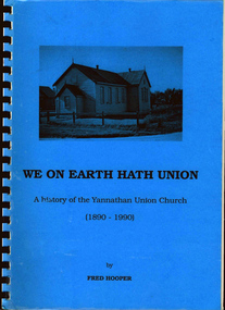
Book, FC Hooper, We on earth hath union : A history of the Yannathan Union Church 1890 - 1990, August 1990
1890-1990 We On Earth Hath Union - A history of the Yannathan Union Church52 p. : ill., ports. ; 30 cm.non-fiction1890-1990 We On Earth Hath Union - A history of the Yannathan Union Churchyannathan (vic.), yannathan--history, yannathan union church (vic.) -
 Monbulk RSL Sub Branch
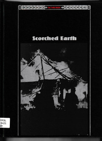
Book, Time Life Books, Scorched Earth, 1991
Chronicles the retreat from the East by Germany during World War IIIndex, bib, ill, maps, p.177.non-fictionChronicles the retreat from the East by Germany during World War IIgermany - history - 1939-1945, world war 1939-1945 - campaigns - eastern europe -
Clunes Museum
Book, MAY TOWNSEND, 1 CRESWICK GIRL GUIDES .2 THE EARTH WE KNOW
.1 A REPORT OF ACTIVITIES OF THE GIRL GUIDES AND .2 A BOOKLET OF POEMS.1 LIGHT GREEN SOFT COVER BOOKLET CRESWICK GIRL GUIDES, REPORT OF ACTIVITIES 1927 TO 1994 .2 CREAM COLOURED SOFT COVER BOOKLET 44 PAGES OF POEMS.1 A REPORT OF ACTIVITIES OF THE GIRL GUIDES AND .2 A BOOKLET OF POEMScreswick girl guides, poetry -
Port Fairy Historical Society Museum and Archives
Functional object - Tin with Lid
Cylindrical tin with lid containing Pears' Precipitated Fuller's Earth. Picture of nurse and baby on lid Domestic ContainerPears' Fuller's Earth is a necessary adjunct to the Nursery and the Toilet as a dusting powder. It is absorbent and prevents irritation due to friction and chaffing. Pears' Fuller's produces a soothing effect and gives a sense of ease and comfort. A & F PEARS. Limited, SYDNEY tin, fullers earth -
 Whitehorse Historical Society Inc.
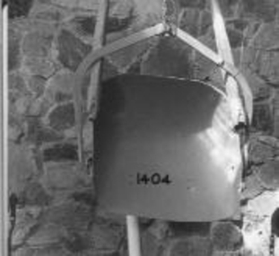
Machine - Horse Drawn Scoop
Used by Mr. Livermore, Snr, and his brothers to construct dams on their properties and for neighbours. It was filled by raising the wooden handle slightly so that the cutting edge bit into the earth. It was tipped by raising the handles higher so that the cutting edge bit in so deeply that the scoop was rotated and emptied.Horse drawn earth moving scoop used for construction of dams, irrigation channels, roads, etc on a farm, orchard, or roads, or where earth needs to be moved. Scoops had no tipping mechanism and needed considerable effort to empty them.rural industry, agriculture, transport, roads -
 City of Moorabbin Historical Society (Operating the Box Cottage Museum)
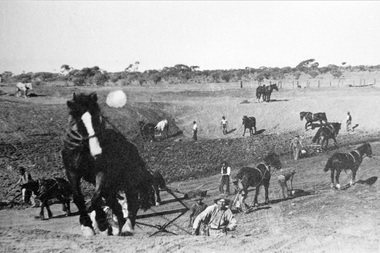
Photograph, Black & White Horse drawn scoops earthwork in Moorabbin Shire c1900, c1900
The, horse drawn metal scoop ,guided by a man, was used to clear earth for road making. Well before the introduction of motorised, mechanical graders and trucks the painstaking, labour-intensive work was undertaken by large teams of sturdy men using strong horses such as the draught horse. Roads were needed by the market gardeners to transport their produce to market. Later as the heavy wagon loads continually caused ruts and general degradation of the roadways a Plateway system was installed so that the wagon wheels could roll along the rails thus protecting the roadways. August 31st 2021 Ron Nash, from WA, informs us "The men and horses pulling earth scoops in the photo are not moving earth for road making - they are excavating an "earth tank", or dam, as described in common nomenclature today. This skill was known as "tank sinking", and tank sinkers were active in many rural and remote areas in the 1800's and early 1900's, establishing sizeable dams for important water reserves for community and farm and railway use. With the advent of mechanised equipment such as bulldozers, the trade of tank sinking was still carried out, but on a faster basis. I am a former tank sinker and earth moving contractor, now long retired." Early settlers in Moorabbin Shire had to build the roads, plateways, drains, as the settlement of the land, in Dendy's Special Survey 1841 Brighton, spread and market gardeners need to transport their produce to market. Their most valuable possession was the draught horse that was used for ploughing, drawing carts and these scoops.Black & White photograph showing many horses pulling metal scoops guided by men to move earth for road making in Moorabbin Shire c 1900Back Handwritten Informationplateway, roadworks moorabbin shire, draught horses, metal scoops, paviers, box alonzo, smith j l; chaff cutter, horse drawn carts, toll gates brighton, motor cars 1900, steam engines, early settlers, bentleigh, mckinnon, parish of moorabbin, city of moorabbin, county of bourke, moorabbin roads board, shire of moorabbin, henry dendy's special survey 1841, were j.b.; bent thomas, o'shannassy john, king richard, charman stephen, highett william, ormond francis, maynard dennis, market gardeners, vineyards, orchards -
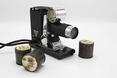 Port Fairy Historical Society Museum and Archives
Education kit - Projector, 1930
Film strips put out by the Visual Centre of the victorian Education Department during the 1940's and 50's as an aid to the teaching of subjects such as Social Studies, English, History. Picturol Projector Model K/ U.S. Patent Nos 1277568- 14342/9 Mr Wilfred Murphy became headmaster of the Port Fairy Consolidated School in the 1950's and retired in the 70's. The projector was used by Mr Wilfred Murphy during the early days of his teaching career. small portable projector in leatherette case with leads to attach to 6 volt battery. seven (7) tins of film - 'The garden that Mary made'/'Our Earth'/ two (2) Copies of 'the Story of the Seed'/ 'Spiders-their Kin'/ 'Camouflage in Nature'/ 'the Story of a Tree'Each tin has a label='The garden that Mary made'/'Our Earth'/ two (2) Copies of 'the Story of the Seed'/ 'Spiders-their Kin'/ 'Camouflage in Nature'/ 'the Story of a Tree'photography, projectors, wilf murphy, education -
Bass Coast Shire Council - Art Collection
Artwork, other - A Hill Somewhere, Julie Lundgren Coulter
AustraliaEarth pigments and charcoalSigned -
 Stawell Historical Society Inc
Slide, Constructing Lake Bellfield
Earth works at lake bellfieldlake bellfield -
Geelong Gallery
Painting - Gipipi, WIRRPANDA, Ms, 2018
Natural earth pigments on stringybark