Showing 517 items
matching east r
-
 Waverley RSL Sub Branch
Photo Album, R. Crockford vx42349
... and Puckapunyal before leaving for the Middle East. Crochford R. Crockford ...This album was prepared from photos take and collected by R Crockford of Benalla Victoria. Spr.R. Crockford VX48349 Joined the 2/8 Fld. Co. Engineers 19 Brigade 6 Div. later transfering to 17 Brigade after leaving Syria in August 1940 and served until November 1945. He trained at Hamilton and Puckapunyal before leaving for the Middle East. Brown Cardboard Photo Albumcrochford, r. crockford, benalla, 2/8 fld. co. engineers 19 brigade 6 div, syria, weewak, palastine, milne bay, wau, salamoa, madang, benalla fire brigade, wwii palestine -
 Bendigo Military Museum
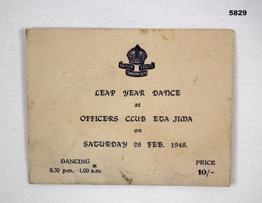
Memorabilia - DANCE TICKET, 1948
... /an enjoyable/ time with/ ...........rly & Colin East/ Jim Godwin, Dan.... "I had/an enjoyable/ time with/ ...........rly & Colin East ...Owner and donor details (see Cat No. 5826P)Ticket - cardboard, black print on off white background with British Commonwealth Forces Coat of Arms, Crown over "BRITISH COMMONWEALTH FORCES" ON BACK OF TICKET - HANDWRITTEN MESSAGE.Back of ticket - handwritten, black ink. "I had/an enjoyable/ time with/ ...........rly & Colin East/ Jim Godwin, Dan Baldwin & ...........A/ lass/ Bldg small but floor passable.memorabilia, military history, japan, bcof -
 Bendigo Military Museum
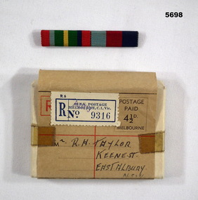
Award - SERVICE RIBBONS IN BOX
1. Service Ribbons issued to all servicemen on active service to indicate area of service. 2. White box containing Ribbons and instructions. Refer 5687 for details. "R. H. Taylor" NX94268.Australian Service medal ribbons made of cloth and mounted on a bar. Two Ribbons to indicate areas of Service. Metallic back with small clips to attach to uniform. Cardboard postage box with a small white sheet of white paper defining contents. Also separate sheet of information on conditions of award and guidance to wearing.Box is addressed to "R.H. Taylor", Keane Street, East Albury, NSW.ribbons, ww2, uniform -
 Federation University Historical Collection
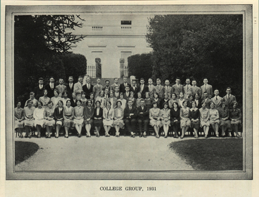
Magazine - Booklet, Ballarat Teachers' College Student Magazine, 'Extra Muros', 1931
A printed magazine of the Ballarat Teachers' College, including a number of black and white photographs. ballarat teachers' college, extra muros, sport, tennis team, hocket team, maclean, ballarat east town hall, theatre, romantic age, athletics, swimming, colin inglis, alex coto, m. fogarty, gladys dunstan, thomas ryan, m.e. bainbridge, nancy larkan, alex a. brown, a.m. kerr, r.w. johnston, r. southwell, m. graham, m.m. o'callaghan, w.j. braden, m. quin, anne vickers, gregor c. mcleod, hazel j. henderon, claire davey, jess higgins, dot watson, c. mccullough, ronnie mcmahon, g. ingpen, m. connolly, w. sudholz, g. turner, norman povey, c. kirk, a. curtis, doris roscoli, kitty kelly, alfred dixon, d.r. anderson, keith m. johnson, arthur h. bryant, m.j. drummond, norna nevett, l.j. miles, dougles mcdowell, m.g. boucher, e.b. tregonning, h.p. doyle, edward russell, lorna mitchell, mac kerrmann, mildred coad, lurline f. desailly, rosa m. fraser, ann saligari, jean baily, meg arnott, r. mcinerny, a.b. stearn -
 Bendigo Military Museum
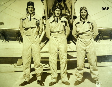
Photograph - PHOTOGRAPH RAAF, c.1936
Given that the photo is 1936 the first two are possibly, F/O Joshua Roger McDONALD No 86, enlisted 15.1.35. At his death on 10.12.1941 he was Wing Commander No 13 Sqd RAAF Darwin. Flying Hudson No A16-69 himself and 3 crew members were killed when the plane crashed into the sea near Ambon Island, Indonesia. Fl/Lt Robert Frederick DALTON No 37, no details of enlistment date. When he was discharged from the RAAF on 16.12.1947 he was Wing Commander at RSTN Laverton (TD & RS) F/O Frederick Attwood WITTSCHEIBE No 89 enlisted on 15.1.1935. At discharge from the RAAF on 21.5.1946 he was Wing Commander at Station HQ East Sale. There is only one WITTSCHEIBE listed on the nominal role. Refer also Reg No 97.Black & white photo of 3 members of A Flight No 21 Squadron in rectangular black timber frame with wire hanger.Hand written on rear: F/O McDonald, FL/Lt R F Dalton, F/O F A Wittscheibe (Born Bendigo 1913, died Bendigo 1998) A Flight No 2 Squadron, circa 1936.military history, photography - group photograph, raaf -
 Bendigo Military Museum
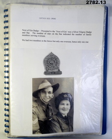
Document - DOCUMENTS WW2, post 1955
Photos relate to CAPTAIN R EMOND's WWII service in the Middle East & North Africa. 2782.7 - 2782.9 relate to Queen Elizabeth's visit to Bendigo in March 1954. 2782.11 & 2782.12 depict soldiers marching through Charing Cross, Bendigo. 2782.13 shows CAPTAIN EMOND & Gov Dallas Brooks inspecting the 38th Battalion.Collection of black & white photos & documents related to CAPTAIN RUSS EMOND. Copied photos & captions have been glued to A4 pages. x 13 pages in blue plastic display folder..13) "14 Mar 55. The Gov of Vic Sir Dallas Brookes inspecting guard of honour from 38 Inf Bn. Guard Commander - Capt Russ Emond"documents - copies, photography-photographs-copies, military history, passchendaele barracks trust -
 Bendigo Military Museum
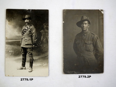
Postcard - POSTCARDS, PHOTOGRAPHIC WW1, Various et al, c.1914 - 1918
.1) Trooper Jack Miller .2) M J O'Donohue .3) & .4) F C Cotton .5) Pte Peter Williams .6) Pte A Bellingham, Queensland .7) D Kearin, G Thorn .8) Pte Roger Fitzpatrick, Maryborough East .9) L/Sgt D D Bruce, Sig W J Wair .10) John Oakes .11) Leslie Bryant .12) Cpt W Turner .13) Sgt T Marshall .14) R W Mattingley .15) Sgt A T Power .16) Sgt Walter Yates .17) Charles Drury .18) Joe O'Neill .19) Les J MartinPhotographs of Australian Servicemen WWI..17) Names on rear.photography-photographs, military history, passchendaele barracks trust -
 Federation University Historical Collection
Letter, Letters written by Richard Squire to his son Tom Squire 1937
In 1905 Richard Squire was manager of the West Berry Consols at Allendale, and developed an improved system of mine ventilation, which was supported in "The Age."[4] He was successful in combating and remedying the gas and ventilation troubles of the Deep Mines of Creswick and Allendale Districts after all had failed. MINE MANAGERS’ ASSOCIATION. Ballarat Branch. ... Mr R. B. Squire, manager of the West Berry Consols, at Allendale, submitted a paper detailing what he had done tor the betterment of ventilation in the alluvial mines of Smeaton and Mary borough districts- Members gave Mr Squire every credit for the results that he claimed to have effected; the adoption of his ideas had testified to their value to mine-owners. It was painted out, however, that for want of a thorough debate of the subject with experienced men the author had unwittingly included some general statements that required modifying in some points and extending in others, in justice to other workers among the earlier and the present day managers of mines. It was decided to invite the author to meet a sub-committee on this subject!A variety of Letters written by Richard Squire to his son Tom Squire about the goings on at Mt Mercer Mine 1937richard squire, tom squire, hazel squire, jack squire, jim squire, ned, mt mercer, plant, skids, pump, poppet, carburetor, shaft, balance weight, pulleys, syndicate, suction, lease, reports, estimates, flat fields, reef, trucks, pipeclay, sandstone, suction pipe, valves, honeycomb rock, yarrowee, ballarat, reef combs, cheques, yellow slate, leigh river, dyke, quartz, ballarat deep leads, ballarat deep leads extension, bore, reads, bedrock, cemented sand, g m of a, gold mines of australia, liz the car, geoff squire, lode, cameron and sutherland, hayes timber, alan squire, ethel, ross creek field, ross creek gold mining co., frank herman, lillas, jack hayes, eyres brothers, g.gay & co, buninyong, glenfine, the star mine of avoca fields, talbot alluvials, guildford plateau, a.b.c. special supply store, geological branch, shell coy, lawaluk, almanac, mcbinny, bingley's paddock, cargaire valley and lead, stand and deliver demands, sheehan's, smeaton hotel, john charleson, aleck charleson, ted brown, billy jordan, mr banks, ballarat main lead, binney, goon, illabrook, mrs trenery, bre, max, june, mary, len, barry, hunter, herman, martin, aunt annie, bella, pitfield coy, mcnaughtons, donaldson, dereel, hogan, the bay leads, avoca field, ballarat alluvials, neil cameron, haddon field, courier, tom cotton, llewellen, stanley hunter, mr leonard, tom mitchell, school of mines, bryant, a.c. connely, dodson, constable mcmullins, adam ronaldson, bewick mining & co., reginald murray, r.c. selwyn, craig's hotel, broken hill syndicate, morrison's lead, wilkinson, j. hayes, mr nichol, burglary, baragwanath, wilkinson ross, creswick, seville, mr. ross, o'connor, c. mcgrath, alfred mica smith, henderson ross, angus kelly, a. r. dodson, duke of wellington plant, the moorabool lead, williams, paralysis, woodlock, squire, whipp, joe williams, peacock, moran, buchanan, hoare, bree kutchel, kohinoor band and alluvian, star of the east, bonshaw, epidemic, polio, mining -
 Federation University Historical Collection
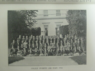
Photograph, Ballarat Teachers' College, 1930, 1930
ballarat teachers' college, ballarat east library, sport, autographs, a.p. hamono, a.b. jones, murial ross, t.m. sturart, margaret connolly, i.m. stuart, loris evans, g. roseshaw, e. smith, bon dickman, john l. murray, ronnie mcmahon, george carey, jan turner, florrie mcguane, r. bowman, l. milllar, r. montgomery, t.h. elwood, peggy skene, a.duggan, m.j. thomas, m.a. fogarty, gladys dunstan, monica o'callaghan, mildred a. graham, doris roscoe, m. callery, mary murray, mary bainbridge, gwen hall, gwen walter, han weir, marion hall, dot rayner, rita martin, clarice l. cox, lena martin, maude giles, molly quinn, flo mcrobinson -
 Federation University Historical Collection
Booklet, The Ballarat School of Mines and Industries 1870-1920 Jubilee Booklet, 1920 (estimated)
The first school of Mines in Australia was established at Ballarat in 1870. At the time of its jubilee (1930) the following people were members of the School Council: W.H. Middleton (President), W.T. Humphreys (VP), J.S. Vickery (VP), F. Barrow, Col. W.K. Bolton, William Baragwanath, A.E. Cutter, J.N. Dunn, G. Fitches, W.H. Fleay, F. Herman. W.D. Hill, T. Hurley, K. Kean. J. Kelly, L. Lederman, Mayor of Ballarat, Mayour of Ballarat East, D. Maxwell, M. Martin, R. Maddern, D. Ronaldson, F. Saunders, R. Stephenson, A.O. Stubbs, R.E. Tunbridge. The School Staff in 1920 comprised: Herbert H. Smith, Walter Rowbotham, Reginald L. Cutter, M.C. Young, Hilda Wardle, M. Wiliamson, P.S. Richards, L.H. Archibald, J. Woods, Ken Moss, W. Kenneth, Mrs McIlvena. B. Robinson, S. Rowe, E. Hope-Jones, Miss Abrams, L.St.G.P. Austin, Alfred Mica Smith, J.R. Pound, Herbert R. Murphy, N.H. Junner, Maurice Copland, L.H. Archibald, E.J.A. McConnon, Newton King, D.m. Hull, T.R. Gordon, John M. Sutherland, T.K. Jebb, Dick Richards, C. Tonkin, A.W. Steane, J. Paterson, H.W. Malin, R.V. Maddison, S.M. Mayo, F.A. King, W.H. Steane, T.R. Gordon, T.A. Williams, H. Waldron, G. Black, E.J. McConnon, R.V. Duncan. R. Cutter, E.G. Vawdrey, Hilda WardleWhite stapled booklet - landscape format - 20pp + soft covers with blue writing. Includes an historical sketch of the Ballarat School of Mines. Contains images of the school from around 1920. The history outlined in the booklet follows: 'Ballarat has helped to influence the life and destinies of Australia in many ways, the recital of which would perhaps prove tedious to the citizens of less favoured localities! However, it can be said, without much fear of contradiction, that only less known thought Australia than its fame as a gold field is the reputation won for it by its school of Mines, ... Ballarat was still quite a new place when the School was founded, but a very propserous and popular place all the same, with a go-ahead lot of citizens brim full of the spirit of enterprise which seemsto animate mining populations generally. Money was plentiful, and they launched out into ventures, which later, were to develop and take the place of the gold mines, while what is more to the point, they understood the value of education. the old digging days were passing away. So far as Ballarat itself was concerned the day of the cradle and tin dish had already passed into an antiquity "as dead and distant as the age of the Tubal Caon," said dir redmond Barry on declaring the School open. Mining had become a serious business, and the mining engineer, the metallurgist, and the geologist had become a power in the land. In these circumstances the suggestions to found a School of Mines met with ready acceptance. The late Mr James M. Bickett had the honor of bringing forward the proposition at a meeting of the Ballarat Mining Board in October, 1869. it was agreed to, and the Government, having been approached for assistance, granted a lease of the old Supreme Court buildings at a nominal reantal. A modest sum, including 100 pounds from the Borough Council of Ballarat West, was subscribed by a number of sympathisers, and on the 26th October, 1870, the inaugural address was delivered by Sir Redmond Barry, the first President of the School. Classes were commenced on the 23rd January, 1871. The students at first were mostly adults. They were chiefly men emloyed at the mines, who had the wisdom and energy to devote their spare time to study, and, though their attendance was somewhat irregular, they made very good progress. Old prints which have been preserved show them at work at furnaces, big bearded men of the old-fashioned type of miner. It is interesting to note that among those who gave evidence and encouragement was Sir Roderick Murchison, who many years before had advised Cornish miners to emigrate to Australia to search for gold, and who in 1848 was in possession of gold ore sent from this country. Sir Roderick sent a parcel of books for the library, and gave useful advice as to the curriculum which should be adopted. The Museum, which now contains a most valuable collection of minerals, was one of the first things attended to, and the reports presented to the Council from time to time speak of additions being made from all parts of the world. New equipment was constantly being added to the School, a good deal of assay work was done, and some specimens were sent from the East Indies for examination as far back as 1873. By this time there was a difficulty in providing accomodation for the students who wished to enrol, and the number of instructors had grown from two to four. In 1882 the first building was being erected on what was then part of the gaol reserve. A little more than ten years afterwards a buildnig formerly serving as a Methodist Church was absorbed, while later on, the demand for accomodation increasing, the attack upon the gaol was renewed. The School continued to grow in reputation and size, and became the science centre of the district, and in 1889 a learge new building was opened by Sir Alexander Peacock. Students came from over seas as well as from all the States of Australia, and after going through their courses they took with them the name and fame of the old School to all parts of the globe. School of Mines boys have played a great part in developing the mining fields of Western Australia, South Australia, and africa, while old students who have made a name in their profession are constantly dropping in to see how the old place is getting along. It was not to be expected, however, that the Ballarat School would be left without rivals, its very success inspiring competition. Mining Schools were started in other parts of Australia, and, at the same time, Victoria ceased to hold first place as a mining state. On the other hand there was a great advance in manufacturing, and the demand for technicaly trained men became a great and as insistent as ever it had been for trained mining men. The Council was quick to adapt the school to the new conditions, and the result is seen in the institution, which is one of Ballarat's proudest possession. Instruction is given in all branches of technical work, and the classes are filled with students who are building up for Ballarat a reputation as an industrial centre, which promises to equal that which it formerly held as a mining town. Owing to its bracing climate, its abundant opportunities for recreations, and its accessibilty, Ballarat as a city is an ideal place for educational purposed, and is yearly becoming more and more appreciated throughout the State. The chairman of one of Ballarat's biggests industries claims that the workman can do twice the day's work here that he can do in Melbourne. he was a little enthusiastic over it, perhaps, but it is a well-known fact that the healthy and invigourating Ballarat climate is conducive to both physical and mental activity, and the records of the School provide ample proof of it. One of the most interesting and successful branches of the School of Mines and Industries - if the name be enlarged with the enlargement of its scope - is the Technical Art School. "The City of Statues" has from its earliest days been a stronghold of art. Art schools have flourised here, and in 1905 the Education Department came to the conclusion that the best thing to do with them was to place them under the management of the School of Mines Council. A magnificent new Technical Art School was built at a cost of some 12,000 pounds on the site of the old Supreme Court building, and was formally opened on the 23rd July, 1915. The results have not only been justified but surpassed all anticipations. The most comprehensive list of subjects is taught, and this list is constantly added to. Students have flocked to the art School, which may be said to occupy a unique position in Australia, and its record of success is really astonishing. Its students supply art teachers for the newer schools that are being built, and many occupy leading positinos in important business houses. So well is its reputation known that orders are constantly being received, not only from Victoria, but from other States, for honor boards and challenge shields to be designed and made. The most recent addition to the School of Mines and Industries is the Junior Technical School, for which a new building is now being erected on a portion of the gaol site, transferred to the School of Mines Counci by the Government. At the present moment temporary quarters are being occupied. Some students after passing through the Junior School go straight to employment, continuing perhaps to attend the evening trade classes, while others move on to the senior School. In a review of the work of the School of Mines mention must be made of a series of industrial research carried out under supervision of the Principal. One in particular, regarding the suitability of the local ores for the manufacture of pigments attracted much attention, while the experiemtns on the manufacture of white potery from Victorian clayes were considered of sufficient importance by the Federal Advisory Council of Science and Industry to warrant the appointment of a special investigator. The results of these have been most encouraging, and may have far-reaching consequences. The vocational training of returned soldiers also should not be overlooked. The work was taken in hand from the first, before the Repatriation Department gave assistance, and now with the help of the department of the School has become one of the largest vocational training centres in Victoria outside of Melbourne. The soldiers, trained in a variety of occupations, have made remarkable progress, and already considerable numbers have found employment in local workshops and factories. To sum up, the School is divided into the following departments, each well staffed and equipped: - The School of Mines, science, and Engineering; the Techncial Art School, the Boys' Junior Technical School, the Girl's Preparatory Technical Classes, Trade Classes, and the Commercial School. The school of Mines, science and Engineering, comprises the following branches: - Mining, Metallurgy, Geology, Electrical Engineering, Civil Engineering, Mechanical Engineering, Applied Chemistry, and Pharmacy. Battery treatments, Cyanide Testing, Smelting, Assays, and Clay Testing from a regular part of the School's work. Students gaining qualifications obtain concession in their courses at the university, should they proceed there to continue their studies. The technical Art school curriculum includes training in all branches of pictorial and applied art, an Architectural Diploma Course, a Draughtman's Course, technical Art teachers' Course, Photography,Ticket Writing, Art Metal Work, Woodcarving, Needlework, and Leather work. The Trade Classes give instruction in Telephone Mechanics, telegraphy, Carpentry, Cabinet Making, Plumbing, Blacksmithing, Fitting, Electric Wiring, and Printing. Numerous Scholarships are offered every year, and altogether students will find few places to equal the Ballarat School of Mines and Industries as a training place for their life's work. One of the first in the continent to be established, its Jubilee finds it still in the front rank, keeping pace with the times, and offering to the youths of this country the means of taking advantage of Australia's teeming opportunities. william, battery, smith, herbert, drawing from the antique, ballarat school of mines botanical gardens, ballarat school of mines, redmond barry, alfred mica smith, james bickett, museum, dick richards, ballarat junior technical school, s m b, ballarat school of mines and industries, ballarat technical art school, model mine, james m bickett, j m bickett, roderick murchison, vocational training rooms, wesley church, methodist church, alexander peacock, lathes, repatriation, repatriatin department, war service, school council, baragwanath, gold mining, mining laboratory, plaster cast, r.w. richards, anniversary, jubilee -
Federation University Historical Collection
Book - Book - Scrapbook, Ballarat School of MInes: Scrapbook of Newspaper Cuttings, Book 24, April 1985 to October 1985
Collection of newspaper articles related to Ballarat School Of Mines.They cover activities and advertisements for staff. The papers concerned are The Courier, Ballarat, The Australian, The Age over the period of 8 April 1985 to 10 October 1985.Book with beige cover, front, spiral bound. teaching positions advertised, pre-employment courses, courses available, industrial electrical engineers society, trevor henderson wins award, geoffrey blainey launches history of the school of mines, wendouree tech high wins football, six-day tree seminar at old ballarat east gardens, ian duggan wins welding award, smb facing big changes, challenges, writing workshops give pleasure, ania walwicz - writer artist, smb's famous head - r w richards, antarctic hero dies - 92, jim bell head of engineering, lee wallis head of plumbing and sheet metal, ballarat council to replace statue of malcolm fraser, staff farewelled, captain moonlight slept here, carpentary at smb will be moved, dick richard's obituary, hairdressing seminar, flagstaff college of tafe, smb, kim odgers first woman - certificate of technology in surveying, apprentices compete in work skill finals, peter brown - carpentry, ricky hains - engineering drawing, craig haintz - fitting and turning, lynn wheeler - hairdressing, brendan mceldrew - fitter, daryl edwards - electrical wiring, phillip smith - construction steelworker, dr murray gillan, former smb student now dean - faculty of engineering - swinburne institute of technology, tom walsh top farm apprentice for 1984, andrew gibbs top sheetmetal apprentice, ballarat unique educational centre, steven smith top motor mechanic for 1984, ricky hains selected fo skill olympics in japan, lynne wheeler wins silver medal in hairdressing, lynne kirkpatrick - most outstanding apprentice of 1985, lynne kirkpatrick - certificate of woolclassing, david brown motor mechanic apprentice, vacc award smb level one apprentice, central highlands/wimmera regional tafe awards, lynne kirkpatrick, wool classer, leigh gillbert building trade, darrenhumphris automotive trades, ian duggan metal trades, peter flett electrical trades, e j tippett resigns from smb council, courses for young job-seekers, $7 million project takes shape, ballarat municipal observatory being restored, breaking down more barriers, disabled employment support, smb grant for job training in modern office skills, ricky hains receives smb's centenary medallion, when centres for disabled will be redundant, nursing aide girls' award, jenny westin, bronwyn fleming, sharon rook, leanne adams, tracey foley, tammy lench, maxine cloks, ministry for arts visit, lydiard street closed between grant and dana streets, dangers that lurk at work, ministry of employment and training, forgotten hero is resurrected, baldwin spencer, barry hill, blackburn report on post-compulsory schooling, schools - what changes are needed, gifts for ballarat gardens, michael taffe presenting rose to smb, heritage roses in australia, courier 10/9/85, meri gracin smbfood services department, chokkie vegetable, learning the skills of hospitality, courier gardening seminar at smb, kevin heinze, smb redevelopment on target, eating their way to health, trevor mckenzie, helen schaper, steven marsden, farmer lynne kirkpatrick outstanding, silvana faulkner equal opportunities officer, women try non-traditional jobs -
 Bendigo Military Museum
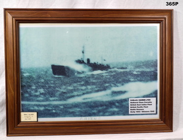
Photograph - PHOTOGRAPH, FRAMED, Post 1945
A highly enlarged, blurry photo, of the warship HMAS Cairns in high seas. The photo has an overall green tint. The dot structure of the enlargement can be seen.Bottom L in green ink: Cairns Bottom R: H.M.A.S. Cairns J183 Bathurst Class Corvette British East Indies Fleet British Pacific Fleet Battle Honours Sicily 1943 / Okinawa 1945photography-photographs, frame accessories, military history - navy -
 Flagstaff Hill Maritime Museum and Village
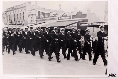
Photograph - Ship's crew, HMAS Warrnambool J202, 1941
This photograph shows the crew of the first HMAS Warrnambool (J202) marching east along Timor Street in Warrnambool, just opposite the Post Office on the corner of Gillies Street. People are watching the parade from the footpath and two boys, dressed in their ‘best’ clothes, are marching alongside the crew. The HMAS Warrnambool was one of 60 Bathurst class corvette vessels built during World War II for the Royal Australian Navy (RAN) as armed minesweepers. The namesake of the City of Warrnambool, Victoria, was launched in Sydney in 1941. The HMAS Warrnambool began service with patrols off Bass Strait in 1941. In December the ship docked in the Warrnambool harbour at Lady Bay. The crew came ashore and performed a march for the city. The Mayor, Cr. John R Astbury presented them with a plaque of the City of Warrnambool’s Coat of Arms and the Warrnambool Patriotic Fund gave them a gift of 110 books for the crew’s library. The Warrnambool served in Darwin during the time it was bombed, it was involved in several rescues and carried troops to New Guinea, it carried out escort and patrol duties on Australia's east coast, then at Fremantle and back to Darwin. The ship was at Timor when the Japanese surrendered in 1945. It performed mine clearance work around the Solomon Islands and New Guinea after the war. In 1947 the HMAS Warrnambool was at the Great Barrier Reef, off the Queensland coast, to clear the defensive British mines previously laid to protect Australia’s boarders. The ship hit a mine near Cockburn Reef, exploded and sank shortly afterwards. One of the 70 or so men on board was killed and three died later. The rescued men were transferred by boats to the nearby HMAS Swan II, which took the survivors to Cairns. The four deceased were Victorian seamen. In May 1948 the Royal Australian Navy divers recovered a number of items from the wreck, including the ship’s bell and the City of Warrnambool plaque. In 1949 the RAN returned the plaque to the Warrnambool City Council, and donated the ship’s bell to the Australian War Memorial. Further objects were recovered in 1972-75 by Southern Cross Diving and Salvage. A memorial plaque was erected in Warrnambool on September 13, 1995 in honour of all who served on HMAS Warrnambool. NOTE: (1)- HMAS Warrnambool II (FCPB204 was built in 1980 in Cairns, with a compliment of 22 personnel. It was decommissioned in 2005. (2)- SS Warrnambool, a steam and sail ship, was built in 1892 in London and broken up in 1926. [A more detailed history can be found in our Collection Record 3477.]This photograph is significant for its association with the lifesaving rescue of the crew and the sinking Royal Australian Navy vessel, HMAS Warrnambool (J202). The HMAS Warrnambool played a nationally significant role in overturning Australia’s Immigration Restriction Act 1901 (colloquially known as the White Australia policy). The ship rescued, and brought to Australia, Samuel and Annie Jacob and their family after they evacuated Dutch East India. The family was threatened with deportation and made the first successful appeal to High Court regarding that Act. The HMAS Warrnambool has - Local significance for being the namesake of the City of Warrnambool - Local significance, having docked in Warrnambool Harbour - Local significance, the crew having paraded in Timor Street, Warrnambool - State significance for its first patrol being in Bass Strait. - National significance, being present in Timor at the Japanese surrender - National significance, shown by the significance of the ship’s bell being curated as Military Heritage and Technology at the Australian War Memorial. - National significance as part of Australia’s defence force history, being one of only four Bathurst class corvettes lost while in Australian service, the only Bathurst class corvette lost after World War II, the only RAN vessel to be sunk by a mine, and associated with the last four Navy deaths of WWIIPhotograph of the crew of HMAS Warrnambool J202. This black and white image shows the crew marching east along Timor Street in Warrnambool. People are watching from the footpath and two formally dressed boys are marching alongside the sailors. Inscription on the reverse.(PRIVATE details - See Notes)flagstaff hill, maritime village, maritime museum, warrnambool, shipwreck coast, mort's dock & engineering co ltd, h.m.a.s. warrnambool, hmas warrnambool, hmas warrnambool i, hmas warrnambool j202, hmas swan ii, j202, world war ii, bathurst class corvette, royal australian navy, ran, sydney built ship, bass strait patrol, sea mine patrol, mine sweeper, mine clearance, navy divers, great barrier reef, cockburn reef, southern cross diving and salvage, warrnambool city council, cr j r astbury, mayor j r astbury, warrnambool patriotic fund, seal, coat of arms, dedicatory plaque, hmas warrnambool 1941, shipwreck by sea mine 1947, sinking ship, sunk ship, marching, parade, timor street warrnambool, minesweeper -
 Flagstaff Hill Maritime Museum and Village
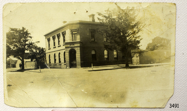
Photograph - Building, Bank of Australasia Warrnambool, ca. 1860
This sepia coloured photograph show the image of the former Bank of Australasia in Warrnambool. The two-storey building was built for the bank on the corner of Timor and Kepler Streets and opened there for business in 1860. It is now one of the City's Historic Buildings. The Bank of Australasia was incorporated by Royal Charter of England in March 1834. It came to Australia on 14th December 1835, opening in Sydney. The Acting Superintendent of the Bank of Australasia in Sydney at that time was David Charters McArthur. He was Superintendent from 1867-to 1876. The Melbourne branch of the Bank of Australasia opened on 28th August 1838 in a two-roomed brick cottage on the north side of Little Collins Street. Two huge mastiff dogs were kept in the backyard and let loose at night to guard the bank. The government also provided an armed military sentinel. Due to the bank's rapid growth, a new building for the Melbourne branch was opened in 1840 at 75 Collins Street West. By 1879 the bank had been upgraded to a magnificent two-storey building on the corners of Collins and Queens Streets, with the entry on Collins Street. In 1951 the Bank of Australasia amalgamated with the Union Bank to form the Australia and New Zealand Bank, now known as the ANZ. Then in 1970, the ANZ merged with both the ES&A and the London Bank of Australia to form the ANZ Banking Group Limited. The ANZ Banking Group Ltd kindly donated a variety of historic items from the Bank of Australasia. BANK of AUSTRALASIA, WARRNAMBOOL – In 1854 Warrnambool had two banks, the Union Back and the Bank of Australasia. Later, completely different bank businesses opened; in 1867 the National Bank of Australasia, then in 1875 the Colonial Bank of Australasia. The original Warrnambool branch of the Bank of Australasia was established in July 1854, and operated from a leased cottage on Merri Street, close to Liebig Street. The bank later bought a stone building previously erected by drapers Cramond & Dickson on the corner of Timor and Gibson Streets. Samuel Hannaford was a teller and then Manager at the Warrnambool branch from 1855 to 1856 and the Warrnambool Council chose that bank for its dealings during 1856-57. In 1859 Roberts & Co. was awarded the contract to build the new Bank of Australasia branch for the sum of £3,000. The land was on a sand hill on the northeast corner of Timor and Kepler Streets and had been bought in 1855 from investor James Cust. The new building opened on May 21, 1860. The bank continued to operate there until 1951 when it merged with the Union Bank to form the ANZ Bank, which continued operating from its Liebig Street building. Warrnambool City Council purchased the former Bank of Australasia building in 1971 and renovated it, then on 3rd December 1973 it was officially opened as the Art Gallery by Cr. Harold Stephenson and Gallery Director John Welsh. The Gallery transferred to the purpose-built building in Liebig Street in 1986 and the old bank building is now the Gallery club. Staff at the Bank of Australasia in Warrnambool included the following men but others were also involved: Samuel Hannaford, Teller then Manager from 1855-1856; W H Palmer, Manager from January 1857 until November 1869 when the Teller Basil Spence was promoted to Manager; H B Chomley, Manager from April 1873 and still there in 1886; A Butt, Manager in 1895-1904; J R McCleary Accountant and Acting Manager for 12 months, until 1900; A Kirk, Manager 1904; J Moore, staff until his transfer to Bendigo in December 1908; J S Bath was Manager until 1915; C C Cox, Manager until April 1923; Richard C Stanley, Manager 1923 to April 1928. The photograph is significant historically for its connection with the Bank of Australasia. The early Australian bank was established in 1834 by Royal Charter and opened in Sydney, Australia, in Sydney in 1835. The bank had many Australian offices in November 1877, particularly on the east and south coasts. Victoria had 45 percent of all Offices. The photograph has local historical significance for its association with the Warrnambool Bank of Australasia, which was established early in Warrnambool's history. It was Warrnambool Council’s first bank. The bank continued to operate until the organisation's merger in 1951 when it became the ANZ Bank Group of today. The Bank was an integral part of the growth of local commerce and the community.Black and white (or sepia) rectangular photograph, landscape orientation. Image of a two-storey building on a street corner. It is the former Bank of Australasia, Warrnambool, on the corner of Timor and Kepler Streets that was built in 1860. The reverse has a round, serrated-edged red label with an inscription, covered in opaque tape, plus four lines of handwritten text. There are several pin holes through the photograph.Label with: "AH2 2 / W.BOOL" Writing in pen: "D. K. Frew / --- / ---- / ----"flagstaff hill, warrnambool, shipwrecked coast, flagstaff hill maritime museum, maritime museum, shipwreck coast, flagstaff hill maritime village, great ocean road, bank of australasia, boa, union bank, australia & new zealand bank, anz bank, david charters mcarthur, d c mcarthur, commerce, banking, samuel hannaford, w h palmer, basil spence, h b chomley, a butt, j r mccleary, a kirk, j moore, j s bath, c c cox, richard c stanley, historic building, roberts & co., james cust, bank of australasia warrnambool -
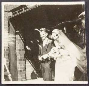
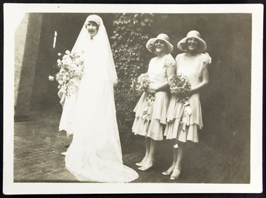 Mission to Seafarers Victoria
Photograph, 15/2/1928
This photograph shows one of the many weddings held at the Mission to Seafarers over the years and provides an overview of wedding fashion of the late 1920s. The Bride is posing in the courtyard of the Mission to Seamen. The bridesmaids were Ella Kendall and Molly Walker. The Walkers and Dora had a long association with the Mission and the LHLG and in the 1960s becoming president of the Flying Angel League which amalgamated with the LHLG in the early 1960s. In 1970 Dora received an OBE. Private images of the day for the record were supplied to the Mission by sons David and Brian in 2018. The article in the Herald of the day describes the event: "WEDDING AT SEAMEN'S CHAPEL Reception at Hotel Windsor The pretty little chapel at the Sea men's Institute was packed with interested friends this afternoon, when Miss Dora Walker, one of the Mission's most enthusiastic and efficient voluntary helpers, chose it as the setting for her marriage with Mr H. P. Simpson, son of Mr and Mrs J. H. Simpson, of Mornington. A group of her fellow workers decorated the chapel with lovely pink and white gladioli, carnations and roses. The ceremony was performed by the Rev. J. R. Weller, chaplain of the Mission, and the bride was given away by her father, Mr A. W. Walker, of Manning road, East Malvern. She wore a lovely ivory georgette frock, the finely tucked skirt being fashioned with a deep transparent hem of Chantilly lace. Over it fell a beautiful Honiton lace veil mounted on tulle and arranged to give the ef fect of a train. Fragrant white roses composed her bouquet. Two attendants followed her down the aisle — her sister, Miss Molly Walker, and Miss Ella Kendall — both wearing dainty shrimp pink georgette frocks and large crinoline straw hats in the same shade with a dainty edging of tulle. They carried bouquets of pink cactus dahlias nnd delphiniums. Mr Louis Buscombe was best man, and Mr George Thompson grooms man. After the ceremony Mr and Mrs Walker entertained about 50 guests at the Hotel Windsor."This photograph shows one of the many weddings performed at the Mission to Seafarers chapel over the years. Cross referencing with the marriage registers, also held in the collection, records that this photograph is Amy Dora Simpson (nee Dora Walker) of East Malvern marrying Harold Priestley Simpson of Surrey Hills / Mornington? on 14 February 1928.Sepia toned photograph of bride and attendants in the courtyard of the Mission to Seafarers. The bride's dress is calf length and she is standing with her veil draped in front of her, holding a large bouquet. There are two attendants to the right of the photograph, wearing layered calf length dresses and wearing cloche hats and holding small posy bouquets. The bridal group is posed standing in in the courtyard near the entrance to the MTS chapel.Small circular Blue ink stamp on rear of photograph: Printed by Harringtons stamped 2 small numerals : 3 and 8hat, flowers, veil, wedding, dress, ivy, shoes, dora walker, dora simpson, ella kendall, molly walker, amy dora walker, reverend j.r. weller, flinders street, st peter chapel, mission to seamen, seamen's mission, mission to seafarers, david simpson -
 Mission to Seafarers Victoria
Photograph, 14 February 1928
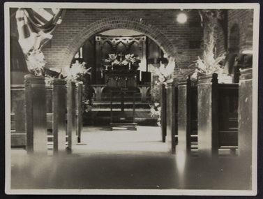
The article in the Herald of the day describes the event: "WEDDING AT SEAMEN'S CHAPEL Reception at Hotel Windsor The pretty little chapel at the Seamen's Institute was packed with interested friends this afternoon, when Miss Dora Walker, one of the Mission's most enthusiastic and efficient voluntary helpers, chose it as the setting for her marriage with Mr H. P. Simpson, son of Mr and Mrs J. H. Simpson, of Mornington. A group of her fellow workers decorated the chapel with lovely pink and white gladioli, carnations and roses. The ceremony was performed by the Rev. J. R. Weller, chaplain of the Mission, and the bride was given away by her father, Mr A. W. Walker, of Manning road, East Malvern. She wore a lovely ivory georgette frock, the finely tucked skirt being fashioned with a deep transparent hem of Chantilly lace. Over it fell a beautiful Honiton lace veil mounted on tulle and arranged to give the ef fect of a train. Fragrant white roses composed her bouquet. Two attendants followed her down the aisle — her sister, Miss Molly Walker, and Miss Ella Kendall — both wearing dainty shrimp pink georgette frocks and large crinoline straw hats in the same shade with a dainty edging of tulle. They carried bouquets of pink cactus dahlias nnd delphiniums. Mr Louis Buscombe was best man, and Mr George Thompson grooms man. After the ceremony Mr and Mrs Walker entertained about 50 guests at the Hotel Windsor."In 1928 there were not many stained glass windows in the chapel, giving that bright light inside.2 original prints and a reprinted versionwedding, dora walker, st peter chapel, flinders street, dora simpson, lhlg, amy dora walker, molly walker, elle kendall, reverend j.r. weller, harry simpson, missals, flowers, bookcase -
 Mission to Seafarers Victoria
Photograph, 14 February 1928
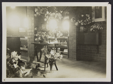
Dora Walker, a member of the Ladies Harbour Lights Guild married H.P. Simpson on 14 February 1928. The wedding was celebrated at the Mission's chapel at 2.45pm. The article in the Herald of the day describes the event: "WEDDING AT SEAMEN'S CHAPEL Reception at Hotel Windsor The pretty little chapel at the Sea men's Institute was packed with interested friends this afternoon, when Miss Dora Walker, one of the Mission's most enthusiastic and efficient voluntary helpers, chose it as the setting for her marriage with Mr H. P. Simpson, son of Mr and Mrs J. H. Simpson, of Mornington. A group of her fellow workers decorated the chapel with lovely pink and white gladioli, carnations and roses. The ceremony was performed by the Rev. J. R. Weller, chaplain of the Mission, and the bride was given away by her father, Mr A. W. Walker, of Manning road, East Malvern. She wore a lovely ivory georgette frock, the finely tucked skirt being fashioned with a deep transparent hem of Chantilly lace. Over it fell a beautiful Honiton lace veil mounted on tulle and arranged to give the ef fect of a train. Fragrant white roses composed her bouquet. Two attendants followed her down the aisle — her sister, Miss Molly Walker, and Miss Ella Kendall — both wearing dainty shrimp pink georgette frocks and large crinoline straw hats in the same shade with a dainty edging of tulle. They carried bouquets of pink cactus dahlias nnd delphiniums. Mr Louis Buscombe was best man, and Mr George Thompson grooms man. After the ceremony Mr and Mrs Walker entertained about 50 guests at the Hotel Windsor."2 original prints and a reprinted version depicting the St Peter chapel decorated with flowers for Dora Walker's wedding in 1928 wedding, dora walker, st peter chapel, mission to seamen, mission to seafarers, flinders st, lhlg, dora simpson, 1928, valentine's day, amy dora walker, ladies harbour lights guild, malvern, reverend j.r. weller, molly walker, ella kendall, flowers -
 Mission to Seafarers Victoria
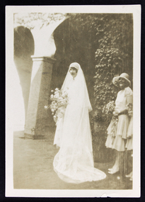
Photograph - Photograph, Sepia, 14 February 1928
Dora Walker was a student of Milverton school, one of the Ladies Schools, a branch of the Ladies Harbour Light's Guild. Amy Dora Walker (known as Dora) of East Malvern married Harold Priestley Simpson of Surrey Hills on 14 February 1928. The bride's maids were Ella Kendall and Molly Walker. The article in the Herald of the day describes the event: "WEDDING AT SEAMEN'S CHAPEL Reception at Hotel Windsor The pretty little chapel at the Sea men's Institute was packed with interested friends this afternoon, when Miss Dora Walker, one of the Mission's most enthusiastic and efficient voluntary helpers, chose it as the setting for her marriage with Mr H. P. Simpson, son of Mr and Mrs J. H. Simpson, of Mornington. A group of her fellow workers decorated the chapel with lovely pink and white gladioli, carnations and roses. The ceremony was performed by the Rev. J. R. Weller, chaplain of the Mission, and the bride was given away by her father, Mr A. W. Walker, of Manning road, East Malvern. She wore a lovely ivory georgette frock, the finely tucked skirt being fashioned with a deep transparent hem of Chantilly lace. Over it fell a beautiful Honiton lace veil mounted on tulle and arranged to give the ef fect of a train. Fragrant white roses composed her bouquet. Two attendants followed her down the aisle — her sister, Miss Molly Walker, and Miss Ella Kendall — both wearing dainty shrimp pink georgette frocks and large crinoline straw hats in the same shade with a dainty edging of tulle. They carried bouquets of pink cactus dahlias nnd delphiniums. Mr Louis Buscombe was best man, and Mr George Thompson grooms man. After the ceremony Mr and Mrs Walker entertained about 50 guests at the Hotel Windsor."A member of the Ladies Harbour Lights Guild, Dora is one of the few ladies who married at the Mission.Sepia toned photograph of bride and attendants in the courtyard of the Mission to Seafarers. The bride's dress is calf length and she is standing with her veil draped in front of her, holding a large bouquet. There is one attendant to the right of the photograph, wearing a layered calf length dress and holding a smaller bouquet. Both are standing in front of one of the columns in the courtyard which has ivy growing over it.Blue ink on rear of photograph: 4 49hat, flowers, veil, wedding, dress, ivy, columns, shoes, dora walker, dora simpson, milverton school, ladies school, lhlg, mrs h.p. simpson, mrs harry simpson, courtyard, amy dora walker, ella kendall, molly walker, reverend j.r. weller, david simpson -
 Mission to Seafarers Victoria
Photograph - Photograph, Sepia, Just married, Harry and Dora, 14 February 1928
The Marriage Register lists Harold Priestley Simpson and Amy Dora Walker as the bride and groom, and the wedding date as 14th of February 1928. The photograph uses the personal Harry and Dora, instead of the formal Harold and Amy. In the Register, Amy started signing her name as Dora. before correcting it. The photograph shows that weddings took place at the Chapel during the late 1920's, and the style of weddings at the time. This includes the type of outfits worn, such as the length of the veil and the type of bouquet carried. Dora's Bridesmaids are depicted in 2 other images in the MTSV collection also an image of the chapel decked with flowers for the occasion. The article in the Herald of the day describes the event: "WEDDING AT SEAMEN'S CHAPEL Reception at Hotel Windsor The pretty little chapel at the Sea men's Institute was packed with interested friends this afternoon, when Miss Dora Walker, one of the Mission's most enthusiastic and efficient voluntary helpers, chose it as the setting for her marriage with Mr H. P. Simpson, son of Mr and Mrs J. H. Simpson, of Mornington. A group of her fellow workers decorated the chapel with lovely pink and white gladioli, carnations and roses. The ceremony was performed by the Rev. J. R. Weller, chaplain of the Mission, and the bride was given away by her father, Mr A. W. Walker, of Manning road, East Malvern. She wore a lovely ivory georgette frock, the finely tucked skirt being fashioned with a deep transparent hem of Chantilly lace. Over it fell a beautiful Honiton lace veil mounted on tulle and arranged to give the ef fect of a train. Fragrant white roses composed her bouquet. Two attendants followed her down the aisle — her sister, Miss Molly Walker, and Miss Ella Kendall — both wearing dainty shrimp pink georgette frocks and large crinoline straw hats in the same shade with a dainty edging of tulle. They carried bouquets of pink cactus dahlias nnd delphiniums. Mr Louis Buscombe was best man, and Mr George Thompson grooms man. After the ceremony Mr and Mrs Walker entertained about 50 guests at the Hotel Windsor."The photograph shows St. Peter chapel was being used for weddings in 1928. The Anglican church has been used for weddings since being finished in 1917. The Marriage Register shows that these weddings were legal in the Commonwealth of Australia, and lists Church of England as the denomination for this wedding. Miss Amy Dora Simpson (nee Walker) had a long association with the Mission, first as a young Volunteer with the Ladies Harbour Light Guild circa WW1, and through to her wedding in early 1928 and beyond. Square sepia, glossy photograph of a bride and groom, taken as they leave a building. Guests are throwing rice at the newlywed. The groom is turned towards the camera, while the bride is looking ahead, carrying a bouquet. There is a white border around top, bottom and left edges, the photograph seems to have been cut in half along the right edge.On the reverse: handwritten in blue pen JUST MARRIED!/DORA & HARRY/28/2/28. 618 is stamped in blue ink . (date is incorrect as wedding took place on 14/2/28)bride, wedding, groom, 1928, dora simpson, dora walker, st peter chapel, harry simpson, lhlg, flinders street, harold priestley simpson, valentine's day, amy dora walker, ladies harbour lights guild, mr and mrs a.w. walker, malvern, manning road, reverend j.r weller, molly walker, ella kendall, david simpson -
Glenelg Shire Council Cultural Collection
Document - Clothing Ration Card, c. 1948
... in 1948 to 'R. Kiel Buln Buln East'. Pale yellow card, red print...Front: 'Kiel R. Buln Buln East' - handwritten, black ink... clothing ration card issued in 1948 to 'R. Kiel Buln Buln East ...Commonwealth of Australia clothing ration card issued in 1948 to 'R. Kiel Buln Buln East'. Pale yellow card, red print. Card complete - 56 ticketsFront: 'Kiel R. Buln Buln East' - handwritten, black ink -
Glenelg Shire Council Cultural Collection
Photograph - Photograph - Shire of Glenelg Councillors, c. 1963
... ''Councillors East Riding' L to R Cr T.J Carey Cr. D. P. Mullane Cr. J.P... ''Councillors East Riding' L to R Cr T.J Carey Cr. D. P. Mullane Cr. J.P ...Sourced from Casterton Town Hall (Former Shire of Glenelg)Black and white photo. Three East Riding Councillors for Shire of Glenelg, sitting at desk, Honour Board on wall behind them with names of Past Presidents of the Shire of Glenelg 1863 -1963 Left to right T. J. Carey (in glasses), D. P. Mullane, J. P. Neylon, Council chambers, Casterton Town HallBack: Black stamp ;\' 003826' ' B' pencil Blue biro line arrowed both ends, drawn across photo. '3" ' above line ''Councillors East Riding' L to R Cr T.J Carey Cr. D. P. Mullane Cr. J.P. Neylon' handwritten in blue birotj carey, d p mullane, jp neylon -
4th/19th Prince of Wales's Light Horse Regiment Unit History Room
Photograph, R McGeehan, Officers of the 7th Light Horse Regiment, 1909
A sepia toned posed photograph of 25 officers of the 7th Light Horse Regiment, with a young boy at centre front, at their Seymour camp in 1909. Mounted on card.R McGeehan Photographer 8 Queen Street East St Kildaphoto, 7th light horse, seymour camp -
 Kiewa Valley Historical Society
Photograph of Kiewa Valley Panorama, Kiewa Valley from No. 5 Road, Before 1945
In 1943 a camp for workmen was erected and a commencement made with the erection of plant storage and workshop buildings in the new township of Mt. Beauty. The photograph was probably taken after the completion of these buildings. There is no sign of construction of the town itself. In the latter part of 1945 work was commenced on the Mt. Beauty township area with a medical centre, general trading store and some houses under construction. The No. 5 Road, from where the photograph was taken, is the road to West Kiewa Power Station and Big Hill Scenic Lookout.Is an excellent view of the Kiewa Valley before there was little work undertaken to establish the town of Mt. Beauty. Farming was well established with the evidence of huge areas of cleared land. The junction of the East and West Kiewa Rivers can be clearly seen. The first Workmen's camp is near the river and some workshop buildings can also be seen. Black and white photograph of the Kiewa Valley, looking North.Handwritten on the back of photograph "Kiewa Valley from No. 5 Road".kiewa valley, camp, buildings, mt. beauty -
 Doncaster RSL Sub Branch
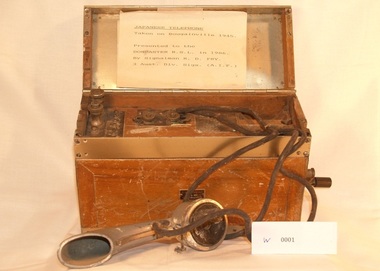
Japanese Bush telephone
Telephone taken on Bougainville 1945 used by Japanese signals Communications presentered to Doncaster RSL in 1986 by signalman R D Fry 3 Aust. div. Sigs. ( A.I.F.)Japanese Army bush telephone in container with manually operated generatormarked in japanese small label on front with number155420 -
 Doncaster RSL Sub Branch
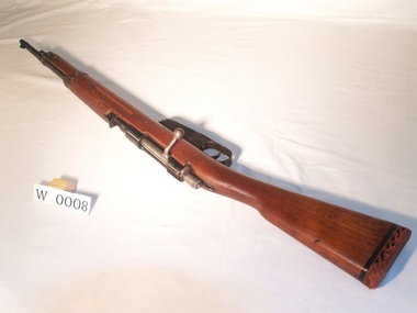
Italian Carcano Model 3 Carbine, R Terni Bnp, Early 20th century
World War Two. Used by the Italian ArmyInfantryman's rifle. Weapon rendered inoperative. -
 Warrnambool and District Historical Society Inc.
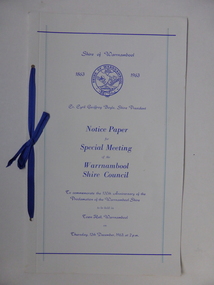
Document, Collett and Bain, Notice of meeting Warrnambool Shire, 1963
This booklet commemorates the 100th anniversary of the proclamation of the Shire of Warrnambool. The original proclamation was read from the Government gazette 13/12/1863 Pg 2958. This follows from being proclaimed a roads district in 1854 which was then partly portioned and proclaimed the Municipal district in 1855. Portion of the shire was again annexed to the city in 1955. The Warrnambool shire covers the area on north east and western sides of the city of Warrnambool covering approximately 600 square miles and has a rich history of farming and dairy products. A program which commemorates 100 years of the shire of Warrnambool. It contains a comprehensive list of councillors who served during that time.White light card cover with royal blue text and tied with royal blue ribbon.Pale blue vertical lines. Shire crest with dates either side at top centre of page.Back cover has list of councillors names who have served from 1863 up to 1963. Photographs in green tinge inside front and back covers. 8 pages. Cr Cyril Geoffery Boyle. Thursday 12th December 1963.Mr Robert Burke, Cr C S Brown, Cr C G Boyle, A F Ponting,The Honourable Murray Porter, Hon R W Mack, Cr J Pascoe, Mr J W Crawley, Mr L Crawley, J Wm Crawley, Jnr, R L Crawleywarrnambool,, warrnambool shire, cr c g boyle, warrnambool shire 1863, warrnambool shire 1963 -
 Warrnambool and District Historical Society Inc.
Note Book, Engineering Drawings, 1919-21
This note book contains handwritten material by Ron Uebergang – notes on engineering drawings prepared for a class at Warrnambool Technical School 1919-1921. Ronald Uebergang (1903-1971) was the son of Ernest and Mary Uebergang. He attended Allansford State School and Warrnambool Technical School and spent his working life dairying and raising cattle on the family property, Hopkins Hill, at Allansford, about nine kilometres east of Warrnambool. He was mechanically minded, fond of music and dancing and a keen photographer. These notes are of interest as they were compiled by Ron Uebergang when he was a student at Warrnambool Technical School 1919-21. The Uebergang families were pioneering settlers in the Allansford area and have been prominent farmers in the area from the 1850s on. The notes also are a good example of the work done by students at Warrnambool Technical School in the 1920s. This is a hand-made book of 22 pages with notes on engineering drawings by Ron Uebergang handwritten in black ink. There is tissue paper inserted between some of the pages. There are several drawings and equations in with the handwritten material. There is some silver fish damage on the front cover. Front Cover: ‘R. Uebergang’ ‘Note Book for Engineering Drawing Grade 3’ ronald uebergang, warrnambool technical school, history of allansford, history of warrnambool -
Ringwood and District Historical Society
season tickets, Ringwood East Football Club Membership Cards and Season Tickets 1963-1978, 1963-1978
Season Tickets for Ringwood East Football Club 1963- 1978 all belonging to Bruce Holliday13 membership cards for Ringwood East Football Club. Season Tickets 1963-1978 as follows: 1963 Blue card of reinforced fabric, member no. 68, Mr Ray Holliday. Includes all fixtures 1964 White card. Ticket no 109 1965 white card No 79 1966 white card No300 1967Lady re Bruce No 55 1968 Lady re Bruce No 238 1969 Gents re R A Holliday No 48 1969 Ladies re Bruce No 280 1970 Gents R A Holliday No 54 1971 Gents no name No 164 1976 Gents no name No 030 1977 Male no name No 153 1978 Male No Name No 066 +Additional Keywords: Holliday, Bruce -
Ringwood and District Historical Society
Programme, Ringwood and District Horticultural and Garden Club, Ringwood and District Horticultural and Garden Club Schedule for the Annual Autumn Show, 1971, 1971
Ringwood and District Horticultural and Garden Club Schedule for the Annual Autumn Show, 1971.12 page booklet- typed Schedule.Front Page Ringwood and District Horticultural and Garden Club Schedule for the Annual Autumn Show To be held in the Assembly Hall, Ringwood High School, Bedford Road, Ringwood Saturday, March 6, 1971. (Doors Open at 2 p.m.) Entries close: 9 p.m. Thursday March 4th, 1971. Admission: Adults: 30 centsChildren: 5 cents Next Page OFFICE BEARERS LIFE MEMBERS: Mrs.Lord, Mrs.W.McDowell, Mr.B.J.Hubbard, Messrs.W.Gillespie, E.Bennett, G.W.Burns, E.T.Kearsley, Les.Ingram, W.McDowell. PRESIDENT:Mr.J.Roberts 39 Warrandyte Road Ringwood, Telephone: 870-1483 VICE-PRESIDENTS: Mrs.D.Hutchinson Mr.V.H.Wilson MENS' COMMITTEE: Mr.G.W.Burns, Mr.W.McDowell, Mr.E.Frame, Mr.V.H.Wilson, MR.J.Percival LADIES COMMITTEE: Mesdames: W.McDowell, D.Hutchinson, A.Mabu, D.Wilson, Miss Isbester TREASURER: Mr.D.Puckey Summit Crescent Ringwood North SECRETARY: Mrs.V.H.Wilson 38 William Street Ringwood, Telephone: 870-7458 ENTRIES CLOSE ON THRUSDAY MARCH 4TH 1971 AT 9 P.M. NO LATE ENTRIES WILL BE ACCEPTED AT THIS SHOW. PROGRAMME Staging of Exhibits 8.30 a.m. till 12 Noon Judging Commences 12.30 p.m. Show Opens 2.30 p.m. Removal of Exhibits 9.00 p.m. Admission: Adults: 30 centsChildren: 5 cents Page One EXHIBITORS MAY MAIL OR TELEPHONE ENTRIES TO THE UNDERMENTIONED:- MRS.V.H.WILSON,38 William Street, Ringwood870-7458 MRS.D.HUTCHINSON, 48 Caroline Street, RINGWOOD 870-8577 ENTRIES CLOSE THURSDAY MARCH 4TH AT 9 P.M. RULES FOR COMPETITORS All Exhibits must be stages by 12 Noon and must not be removed before 9 p.m. Exhibitors must apply on moring of Show to the Secretary for Cards which must be placed in front of Exhibit in the allotted space. All Exhibits, except Floral Art, must be grown by the Exhibitor. Awards will be made by the Judges whose decision is final. Prize Money available at 8 p.m. and if not claimed within one month will revert to the Society. Exhibits should be names. In a close finish this counts. No Exhibitor allowed in Hall whilst Judging is in progress. Any Protest shall be in writing accompanied with a 50 cent deposit lodged with the Secretary before 7 p.m. on day of Show. Protest must be limited to non-accordance of an Exhibit within the Schedule. The Committee is empowered to determine and protest to be forfeited if it deems such to be frivolous. BOWL:- The width of the vessel must be greater than its height. VASE:- The height of the vessel must be greater than its width. Page Two Continuation of: RULES FOR COMPETITORS... The Rules of the Royal Horticultural Society of Victoria will apply. Dahlias will be judged under the Rules and Standards laid down by the National and Royal Dahlias Society of Victoria. A VASE consists of 3 to 6 stems (in Cut Flowers) unless otherwise stated. AWARDS: Bronze Medal of the National Dahlia Society for Best Dahlia Exhibit. BLUE RIBBONS MAY BE AWARDD FOR:- BEST VASE OF CUT FLOWERS BEST DAHLIA OVER 6 INCHES BEST VASE DAHLIAS UNDER 6 INCHESBST FLORAL ART EXHIBIT BEST SEEDLING DAHLIA CERTIFICATES OF MERIT:- GIANT DAHLIA OVER 8 INCHESBEST SHRUB MINIATURE CACTUS DAHLIA BETWEEN 4 1/2" TO 6" BEST POT PLANT CHARM DECORATIVE BETWEEN 6' AND 8' BEST VEGETABLE BEST SINGLE ROSE UNLESS OTHERWISE STATED ENTRY FEE PER SCHEDULE CLA CLASS - 5 CENTS PER ENTRY. PLEASE NOTE THAT ENTRY FEE FOR ITEMS NO. 1 AND 2 IS 25 CENTS IN EACH SECTION ENTRIES CLOSE: THURSDAY MARCH 4TH, 1971 AT 9 P.M. Page Three VICTORIANCHAMPIONSHIPSECTION 1 SCH.NO: FIRST 1DAHLIAS UNDER 8 INCHES 12 Vases (3 of each) Distinct Varieties TROPHY VALUED AT $5.00 29 Giant Dahlias, Distinct Varieties (SPONSORED BY AMETCO TRAVEL AGENCY, RINGWOOD) To be won Three Times - Trophy valued at $20-00 DAHLIAS OPEN SECTION 2 39 Dahlias 3 Medium Cactus, 3 Miniature Cactus, 3 Charm Cactus, Distinct Varieties, Shown separately $2-00 44 Giant Decorative, Distinct Varieties 50c. 51 Giant Decorative 30c. 63 Giant Cactus, Distinct Varieties 50c. 71 Giant Cactus 30c. 86 Medium Garden Cactus N.N.D. 50c. 93 Medium Garden Cactus, Distinct Varieties 50c. 10 3 Medium Decorative Distinct Varieties 50c. 11 1 Medium Decorative 30c. 12 6 Vases Miniature Cactus, Distinct Varieties - 3 of each - 75c 13 3 Vases Miniature Cactus, Distinct Varieties - 3 of each - 50c 14 3 Vases Miniature Decorative, Distinct Varieties - 3 of each 50c 15 1 Vase Miniature Dahlias - 3 Blooms Distinct Variety 30c 16 3 Vases Charm Cactus, Distinct Varieties - 3 of each - 50c 17 3 Vases Charm Decorative - Distinct Varieties - 3 of each 50c Page Four Continuation of: SECTION 2 - DAHLIAS OPEN. SCH.NO. FIRST 18 1 Vase Charm, 3 Blooms, Distinct Variety30c 19 Seedling Dahlia Over Six Inches30c 20 Seedling Dahlia Under Six Inches 30c 21 3 Vases Pompones, Distinct Varieties, 3 of each50c 22 1 Vase Pompones, N.N.D, 50c 23 3 Exhibition Cactus Distinct Varieties 50c 24 1 Exhibition Cactus30c 25 1 Miniature Dahlia20c 26 1 Charm Dahlia 20c 27 1 Vase Dahlias Under 8 Inches, 10 Stalks, N.N.D. 75c SECTION 3: RINGWOOD AND DISTRICT AMATEUR CHAMPIONSHIP DAHLIAS - AMATEUR 28 6 Giant Dahlias, Distinct Varieties $1.00 29 9 Dahlias Distinct Varieties (Shown Separately) 3 Medium Cactus; 3 Miniature Cactus, 3 Charm Cactus $2.00 30 3 Giant Decorative Distinct Varieties 50c 31 1 Giant Decorative30c 32 3 Giant Cactus, Distinct Varieties 30c 34 3 Medium Decoratve Distinct Varieties 50c 35 1 Medium Decorative 30c 36 3 Medium Cactus Distinct Varieties50c 37 1 Medium Cactus 30c 38 3 Vases Miniature Cactus Distinct Varieties (3 of each) 50c 39 1 Vase Miniature Cactus 3 Blooms N.N.D. 50c 40 1 Vase Miniature Decorative 3 Blooms N.N.D.50c Page Five Continuation of: SECTION 3 - AMATEUR DAHLEA CLASS SCH.NO: FIRST 413 Vases Charm Cactus, Distinct Varieties - 3 of each -50c. 421 Vase Charm Cactus, Distinct Variety - 3 Blooms - 30c 433 Vases Charm Decorative, Distinct Varieties, 3 of each50c 441 Vase Charm Decorative 5 Blooms N.N.D. 30c 451 Vase Miniature, 3 Blooms, N.N.D.20c 461 Charm 471 Vase Pompones 5 Blooms N.N.D.50c 481 Vase Show or Ball Dahlias 3 Blooms N.N.D. 50c. SECTION 4: DAHLIAS - NOVICE 491 Giant Dahlia 30c 501 Medium Dahlia 30c 511 Vase Miniature Dahlias, 3 Blooms, N.N.D.30c 521 Vase Charm Dahlias, 3 Blooms, N.N.D. 30c 531 Miniature Dahlia20c 541 Charm Dahlia 20c SECTION 5:R O S E S-O P E N 55Roses, 3 Blooms in Separate Containers, (Distinct Varieties)40c 56Roses, 3 Blooms, 1 colour shown separately 30c 57Roses, 3 Blooms, Bud to Full Bloom 30 c 58Roses, 3 Vases, Distinct Varieties 75c 59Roses, 1 Vase Full Bloom showing stamens 30c 60Roses, 1 Vase C.V.A. 20c Page Six Continuation of: SECTION 5 - R O S E S-O P E N SCH.NO:FIRST 611 Rose in Bloom20c 62Rose, 1 Vase of Floribunda or Grandiflora 30c SECTION 6 - R O S E S - A M A T E U R 63Rose, 1 Bloom20c 64Rose, 1 Vase, C.V.A. 30c 65Roses, 3 Blooms, Distinct Varieties35c 66Roses, 3 Blooms, Bud to Full Bloom 35c 67Roses, 1 Vase Floribunda or Grandiflora30c SECTION 7C U T F L O W E R S -O P E N 683 Vases Cut Flowers, Distinct Kinds, C.V.A. 50c 691 Vase Cut Flowers, Distinct Variety, C.V.A. 25c 701 Vase Cut Flowers, Red Shades, Distinct Kind 25c 711 Vase Cut Flowers, Pink Shades, Distinct Kind25c 721 Vase Cut Flowers, White Shades, Distinct Kind 25c 731 Vase Cut Flowers, Cream or Yellow Shades25c 741 Vase Cut Flowers, Blue Shades 25c 751 Head Hydrangeas25c 763 Vases Geranium or Pelargonium, N.N.D. 25c 771 Vase Asters, C.V.A.25c 781 Vase Zinnias, Distinct Variety, Dahlia Flowered25c 793 Vases Zinnias, Distinct Colours, Dahlia Flowered 25c 801 Vase Lilliput Zinnias, C.V.A. 25c 811 Vase Marigolds. C.V.A. 25c 821 Vase Cut Flowers, not shown in this Schedule 25c 831 Vase Decorative Chrysanthemum, C.V.A., A.N.S.25c Page Seven Continuation of: SECTION 7:CUT FLOWERS - OPEN - SCH.NO: FIRST: 841 Container phlox, C.V.A.25c SECTION 8C U TF L O W E R S - AMATEUR 853 Vases Cut Flowers, Distinct Kinds, C.V.A. 40c 861 Vase Cut Flowers, Distinct Variety, C.V.A. 25c 871 Vase Cut Flowers, Red Shades, Distinct Kinds25c 881 Vase Cut Flowers, Red Shades, Distinct Kinds 25c 891 Vase Cut Flowers, Blue Shades, Distinct Kinds 25c 901 Vase Cut Flowers, White Shades, Distinct Kinds 25c 913 Vases Fuchsias, C.V.A.25c 923 Vases Geraniums or Pelargoniums (N.N.D.) 25c 931 Vase Aster, C.V.A.25c. 941 Vase African Marigolds, Distinct Variety 25c 951 Vase Zinnias, Dahlia Flowered, C.V.A. 25c. 961 Vase Cut Flowers not stated in Schedule 25c 971 Flower not stated in Schedule 25c 981 Vase Geranium, Distinct Variety25c 991 Container Phlox25c Page Eight SECTION 9 - C U T F L O W E R S - N O V I C E SCH.NO:FIRST: 1001 Vase Asters 25c 1011 Vase Snap Dragons C.V.A.25c 1021 Vase Marigold C.V.A.25c 1031 Vase Zemias, Dahlia Flowered, C.V.A. 25c 1041 Vase Zemias, Lilliput, C.V.A. 25c 1051 Container Phlox 25c SECTION 10 F L O R A L A R T O P E N FIRST SECOND 106Arrangement of Flowers for the Home50c 20c 107Table Centre Piece of Mixed Flowers 50c 20c 108Bowl of Dahlias 50c 20c 109Arrangement of Autumn Tones (Any Foliage Allowed)50c 20c 110 Arrangement of Flowers (Dahlias to predominate - May include any plant material and accessories)$1-00 50c 111Dry Arrangement 50c 20c 112Church Arrangement 50c 20c 113A Basket of Fruit 50c 20c 114Line Arrangement (May include any Plant Material) 50c 20c 115"AS I LIKE IT" (May include any Plant Material and Accessories) 50c 20c 116Arrangement, Tall and Stately 50c 20c 117Bowl of Floating Flowers (FLOWERS MUST FLOAT)35c 15c Page Nine SECTION 11 F L O R A L A R T - A M A T E U R SCH.NO: FIRST:SECOND: 118Arrangement of Dahlias35c 15c 119Miniature Arrangement 50c 15c 120Harvest Arrangement of Flowers and/or Vegetables 40c20c 121Arrangement of Gladioli 35c 15c 122One Flower Spray30c 15c 123Arrangement of Five Dahlias 35c 15c 124Presentation Basket50c 20c 125Arrangement in Pink and Gray on Silver 40c 20c S P E C I A L N O T I C E PLEASE NOTE THAT SCHEDULE NUMBERS 106, 118 AND 120, TO BE EXHIBITED IN 2FT.6IN. NICHE.. SECTION 12 F L O R A L A R T - INTERMEDIATE SCH.NO: FIRST: SECOND: 126A Dry Arrangement 30c15c 127Presentation Basket40c20c 128Tall Arrangement 30c15c 129Line Arrangement Five Flowers40c20c ENTRIES CLOSE THURSDAY MARCH 4TH, 1971 AT 9 P.M. Page Ten SECTION 13 F L O R A L A R T - N O V I C E SCH.NO:FIRST: SECOND: 130"My Choice" 30c 15c 131Dry Arrangement 30c 15c 132One Flower Spray 30c 15c 133Presentation Basket 40c 20c 134Arrangement, "AS I LIKE IT"30c 15c SECTION 14V E G E T A B L E S SCH.NO:FIRST: 135Collection of not more than 8 Vegetables $1.50 136Brace (2) of Apple Cuccumbers25c. 137Brace (2) of Long Cuccumbers 25c 138Plate of 4 Tomatoes, smooth, (eith Stalks) 25c. 139Plate of 4 Onions25c 140One Vegetable Marrow25c 141One Pumpkin 25c 142One Lettuce25c 143Plate of Peas - 12 Pods - 25c 144Plate of Climbing Beans - 12 Beans25c. 145Plate of Dwarf Beans - 12 Beans - 25c 146Bunch of Three Carrots with Tops25c 147Bunch of Three Parsnips 25c 148One Head Silver Beet25c 149Plate of 4 Potatoes25c 150Bunch of 3 Red Beet with Tops 25c 1513 Sticks of Rhubarb with Leaves25c 152Vegetable not otherwise specified 25c 1533 Cobs Sweet Corn25c. Page Eleven SECTION 14 - F R U I T SCH.NO: FIRST: SECOND: 154A Dish of 4 Culinary Apples 25c 155A Dish of 4 Dessert Apples 25c 156A Dish of 4 Lemons 25c 157A Dish of 6 Passion Fruit 25c 158A Fruit not otherwise stated 25c SECTION 15 - FLORAL ART - CHILDREN 11 TO 14 YEARS 159Floral Mat 12 inches by 9 inches 75c25c 160Arrangement of 3 Flowers (Any Foliage) 20c10c 161Decorated Saucer of Flowers20c 10c 162Flower Arrangement in Egg Cup 20c10c 163Novelty of any Horticultural Material20c 10c 164Boquet of Flowers 20c 10c 165Miniature Arrangement not to Exceed Three Inches 20c 10c. 166Arranged Vase of Flowers 20c 10c 167Arranged Vase of 6 Dahlias20c 10c. SECTION 16SPECIAL FUCHSIAS SECTION 168Single, 3 Distinct Variety 169Single, 6 Distinct Variety 170Single, 3 C.V.A. 171Single, 6 C.V.A. 172Double, 3 Distinct Variety 173Double, 6 Distinct Variety 174Double, 3 Distinct Variety 175Double, 6 C.V.A. Page Twelve Fuchsias Florets to be displayed on collar in a container (Small). Containers and Collars will be supplied by the Club, PRIZE-CARDS - FIRST, SECOND, WILL BE AWARDED ALSO MERIT CARD. A TROPHY WILL BE AWARDED TO THE BEST EXHIBIT IN SPECIAL FUCHSIAS SECTION SPECIAL OPEN CLASS - POT PLANTS.... SCH.NO:FIRST: 1761 Pot Plant, Foliage30c 1771 Pot Plant, Orchid In Bloom 30c 1781 Pot Succulents 30c 1791 Pot Geranium in Bloom 30c 1801 Pot Geranium Foliage 30c 1813 Indoor Plants - Different Varieties 30c 1825 Pots, at least 3 in Bloom 30c 183Container of Mixed Plants 30c 1841 Pot Plant in Bloom 30c Back Page G A R D E N C O M P E T I T I O N G A R D E N C O M P E T I T I O N sponsored by RINGWOOD CITY COUNCIL (Entries close Thursday February18th) (JUDGING SATURDAY FEBRUARY 27TH, 1971) ENTRIES MAY BE LEFT WITH: MRS.D.HUTCHINSON MRS.V.H.WILSON 43 Caroline Streetor38 William Street RINGWOOD RINGWOOD 870-8577870-7458 JOIN THESOCIETY Our MONTHLY MEETINGS are held on the THIRD MONDAY at 8 p.m. on each month in the PUBLIC LIBRARY, Warrandyte Road, RINGWOOD. YEARLY SUBSCRIPTION: ONE DOLLAR ($1-00) C H R Y S A N T H E M U M S H O W SATURDAY, MAY 8TH, 1971 WATCH FOR FURTHER DETAILS Sunrise Secretarial Service, 12 Grey Street, Ringwood East Telephone: 870-6871 -
 Ringwood and District Historical Society
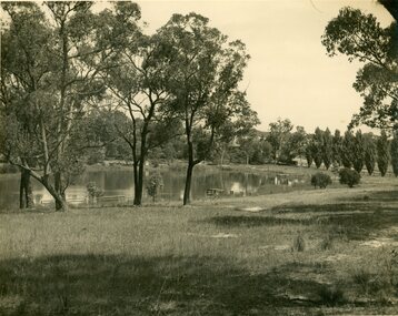
Photograph, R. Pullin, Ringwood Lake 1946, 1946
Ringwood Lake 1946, photograph by R. Pullin looking across lake from east side. Maroondah Highway can be seen on right hand side with avenue of poplars.