Showing 66 items matching "eltham north (vic)"
-
 Eltham District Historical Society Inc
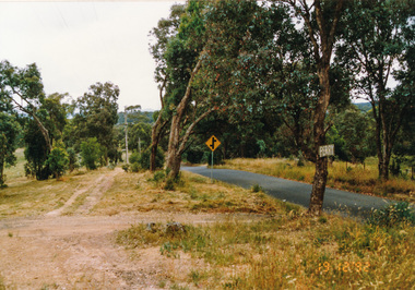
Photograph, Ingrams Road looking north to Allendale Road, Research, 19 December 1992, 19/12/1992
The Eltham Horse Trail: Research and Warrandyte to Kinglake: Survey of proposed route, December 1992: (4) Connecting trail to ElthamColour photographeltham horse trail (1992 survey), allendale road, ingrams road, research (vic.) -
 Eltham District Historical Society Inc
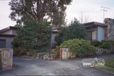
Photograph, 31 Pryor Street, Eltham, June 1999, 1999
Owner 1940-50: Mr and Mrs Barker; 1960s: Vera Barker and Colin Barker On 23 July 2019 this house and fence and garden was demolished. https://www.realestate.com.au/property/31-pryor-st-eltham-vic-3095The Margaret Ball (Pre 1960s Houses) Collection was a personal project initiated to mark the year 2000 and arose as a result of the disappearance of many pre-1960s parts of Eltham due to development. Approximately 200 pre-1960s style houses that were left in Eltham between Main Road and east to Bible Street, between Cecil Street to the north and south to Dalton Street were photographed in late 1999. Not all of the houses could be photographed; some because the garden or trees blocked the view of the house, others because of rubbish or cars were in the way, some because people were working on the house or in the gardens at the time.Roll of 35mm colour negative film, 10 stripsFuji 200eltham, houses, streets, margaret ball (pre 1960s houses) collection, pryor street -
 Greensborough Historical Society
Poster - Planning Document, Shire of Diamond Valley et al, Subdivision Plan # 1018 - Parish of Nillumbik, County Bourke, Crown Allotment 4 Section 15, and Crown Allotment B Section 12, Eltham North, 1981-1982
Subdivision Plan # 1018 - Parish of Nillumbik, County Bourke, Crown Allotment 4 Section 15, and Crown Allotment B Section 12, Eltham North. This subdivision plan includes Ryans Road (also known as Government Road) and St Clems Street. The developer for this subdivision is Taunton Developments and the Surveyors are Fisher Cleeland Turner & Dwyer Vic, Surveyors and Engineers.An example of hard copy subdivision plans from the Greensborough area. Mainly from the Shire of Diamond Valley era (1964-1994).Plan (single sided) mounted on heavy card. Stamped and handwritten Council permissions, dates and other details. subdivision plans, shire of diamond valley, taunton developments -
 Greensborough Historical Society
Poster - Planning Document, Shire of Diamond Valley et al, Subdivision Plan # 1026 - Parish of Nillumbik, County Bourke, Crown Allotment B Section 12, Eltham North, 1981-1984
Subdivision Plan # 1026 - Parish of Nillumbik, County Bourke, Crown Allotment B Section 12, Eltham North. This subdivision plan includes Ryans Road (also known as Government Road) and St Clems Street. The developer for this subdivision is Taunton Developments and the Surveyors are Fisher Cleeland Turner & Dwyer Vic, Surveyors and Engineers.An example of hard copy subdivision plans from the Greensborough area. Mainly from the Shire of Diamond Valley era (1964-1994).Plan (single sided) mounted on heavy card. Stamped and handwritten Council permissions, dates and other details. subdivision plans, shire of diamond valley, taunton developments -
 Greensborough Historical Society
Poster - Planning Document, Shire of Diamond Valley et al, Subdivision Plan # 1044 - Parish of Nillumbik, County Bourke, Crown Allotment B Section 12, Eltham North, 1981-1987
Subdivision Plan # 1044 - Parish of Nillumbik, County Bourke, Crown Allotment B Section 12, Eltham North. This subdivision plan includes Weidlich Road and St Clems Street. The developer for this subdivision is Taunton Developments and the Surveyors are Fisher Cleeland Turner & Dwyer Vic, Surveyors and Engineers.An example of hard copy subdivision plans from the Greensborough area. Mainly from the Shire of Diamond Valley era (1964-1994).Plan (single sided) mounted on heavy card. Stamped and handwritten Council permissions, dates and other details. subdivision plans, shire of diamond valley, taunton developments -
 Eltham District Historical Society Inc
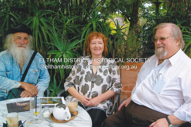
Photograph, Fay Bridge, Book launch of Laughing Waters Road by Jane Woollard at Montsalvat, Eltham, 30 January 2016
Laughing Waters Road , the book was launched at Montsalvat in Eltham. On Saturday, January 30, 2016, Nillumbik Council launched this book. The weather was cool; just as well, considering over 500 people attended this very pleasant event where food and drink were plentiful. The Australian Government and Nillumbik Shire Council funded the book and it was designed by Wayne Rankin of North Warrandyte. The dedication page is to our very own Ranger Campbell Beardsell OAM of Parks Vic who taught Jane to be “passionate about the environment of this special place” (p260). FOWSP members Val Polley, Linda Rogan and Ken Crook contributed to the content and photos. David Wandin, Wurundjeri Elder, gave a Welcome to Country and officially launched the book after the Mayor of Nillumbik, Cr Hattam, made introductions. Jane Woollard followed with a brief outline of how she came to write the book (her very first) and read out loud the last paragraph which focuses on reconciliation and shared culture. Jane declared in her preface that the book “has been formed by attending to the connection between rivulets of memories, creeks of hearsay, rivers of tales, the meanders of local legend and the deep, still pools of the archive.” Very poetic! - Lynda Gilbert Newsletter; Friends of Warrandyte State Park March 2016, Volume 34 Number 2 Laughing Waters Road , the book was launched at Montsalvat in Eltham ON SATURDAY 30 JANUARY Nillumbik Council launched this book. The weather was cool; just as well, considering over 500 people attended this very pleasant event where food and drink were plentiful. The Australian Government and Nillumbik Shire Council funded the book and it was designed by Wayne Rankin of North Warrandyte. The dedication page is to our very own Ranger Campbell Beardsell OAM of Parks Vic who taught Jane to be “passionate about the environment of this special place” (p260). FOWSP members Val Polley, Linda Rogan and Ken Crook contributed to the content and photos. David Wandin, Wurundjeri Elder, gave a Welcome to Country and officially launched the book after the Mayor of Nillumbik, Cr Hattam, made introductions. Jane Woollard followed with a brief outline of how she came to write the book (her very first) and read out loud the last paragraph which focuses on reconciliation and shared culture. Jane declared in her preface that the book “has been formed by attending to the connection between rivulets of memories, creeks of hearsay, rivers of tales, the meanders of local legend and the deep, still pools of the archive.” Very poetic! - Lynda Gilbert Newsletter; Friends of Warrandyte State Park March 2016, Volume 34 Number 2 https://fowsp.org.au/docs/News_2016/34_02_March.pdffay bridge collection, 2016-01-30, book launch, bronnie hattam, jane woollard, laughing waters road, montsalvat, sigmund jorgensen, harry gilham, maurice hurry