Showing 402 items
matching enders bridge
-
 Eltham District Historical Society Inc
Photograph, Russell Yeoman, Fitzsimons Lane Bridge over Yarra River between Eltham and Templestowe, c.1970, 1970c
... of the river. In 1991 a new bridge was built to the west... of the river. In 1991 a new bridge was built to the west ...The bridge over the Yarra River was initially opened September 22nd, 1961. Newspaper reports at the time of opening stated it linked Bolton Street, Eltham, with Fitzsimons Lane, Templestowe. In 1955 the Country Roads Board (CRB) produced survey plans that showed proposed land acquisition for the future bridge and road approaches. The 1955 plan shows that it was proposed to connect Fitzsimons Lane with Bolton Street in Eltham by a diagonal road across the river. The road connection would then continue along Bolton Street to Main Road. Prior to construction of the bridge the CRB modified the proposal significantly so that there was a new road parallel with Bolton Street and then curving to join Main Road at what was then its intersection with Old Eltham Road. This involved significantly more land acquisition and altered the pattern of land subdivision through this corridor. Initially the new road was just a single two-way carriageway as it would have required a significant widening of the cutting on the Shire of Eltham side of the river. The road was officially un-named but was known locally as the Eltham-Templestowe Road. The 1966 Melway street directory and other 1960s editions also listed the road as the Eltham-Templestowe Road. In December 1970, Eltham Shire Council, in pursuance of the provisions of the Local Government Act, named it Templestowe Road. The road was renamed Fitzsimons Lane around 1984 in conformity with the section south of the river. In 1991 a new bridge was built to the west of the original bridge. Fitzsimons Lane was widened to four traffic lanes although on the Eltham side this was done within the limits of the existing cutting. NEW BRIDGE STARTS THEM EXPLORING Without any fanfares, Country Roads Board workmen on Friday afternoon put the finishing touches to the approaches, removed the barricades, and let the traffic roll over the new Yarra bridge linking Bolton Street, Eltham, with Fitzsimons Lane, Templestowe. Over the week-end many “bridge watchers” who were making one of their periodic inspections of the progress on the new bridge found to their surprise that they could drive over it, so that people who had gone for a run out to Eltham suddenly found themselves wandering through Templestowe and Doncaster. By Monday the word of the bridge’s opening had got around sufficiently for many regular travellers to the city from Eltham and beyond to vary the monotony by going to town via Templestowe and Kew instead of through Heidelberg. They were surprised at the distances – about 3 ½ miles from Eltham to Templestowe, 6 miles from Eltham Shire hall to the Lower Heidelberg Road-Banksia Street intersection. NEW NEIGHBOURS For people on both sides of the river, the new bridge has turned distant friends into near neighbours. A Greensborough man on Sunday took 35 minutes to reach the home of a friend in East Doncaster, but the return trip over the new bridge took only 17 minutes. It will be some time yet before most people work out the possibilities in shorter and quicker trips form the north-eastern areas to the eastern and south-eastern suburbs. The coming of the warmer months will soon teach many, though the short cuts to Peninsular beaches and eastern suburban drive-ins. And before very long it is likely there will be a Tramways bus running from Templestowe to Eltham station. NEW BRIDGE STARTS THEM EXPLORING (1961, September 27). The Diamond Valley News (News clipping held in SEA_74-1_047) The previously un-named road between Main Road and Yarra River, Eltham South, east of Bolton Street was named Templestowe Road, December 15, 1970 NAMING OF STREETS AND ROADS. (1970, December 15). The Diamond Valley News (News clipping held in SEA_74-2_022)Roll of 35mm black and white negative film, 4 of 7 stripsIlford HP4bridge, bridges, fitzsimons lane bridge, infrastructure, shire of eltham infrastructure, yarra river -
 Eltham District Historical Society Inc
Photograph, Fitzsimons Lane Bridge over Yarra River between Eltham and Templestowe, c.1966, 1966c
... of the river. In 1991 a new bridge was built to the west... of the river. In 1991 a new bridge was built to the west ...The bridge over the Yarra River was initially opened September 22nd, 1961. Newspaper reports at the time of opening stated it linked Bolton Street, Eltham, with Fitzsimons Lane, Templestowe. In 1955 the Country Roads Board (CRB) produced survey plans that showed proposed land acquisition for the future bridge and road approaches. The 1955 plan shows that it was proposed to connect Fitzsimons Lane with Bolton Street in Eltham by a diagonal road across the river. The road connection would then continue along Bolton Street to Main Road. Prior to construction of the bridge the CRB modified the proposal significantly so that there was a new road parallel with Bolton Street and then curving to join Main Road at what was then its intersection with Old Eltham Road. This involved significantly more land acquisition and altered the pattern of land subdivision through this corridor. Initially the new road was just a single two-way carriageway as it would have required a significant widening of the cutting on the Shire of Eltham side of the river. The road was officially un-named but was known locally as the Eltham-Templestowe Road. The 1966 Melway street directory and other 1960s editions also listed the road as the Eltham-Templestowe Road. In December 1970, Eltham Shire Council, in pursuance of the provisions of the Local Government Act, named it Templestowe Road. The road was renamed Fitzsimons Lane around 1984 in conformity with the section south of the river. In 1991 a new bridge was built to the west of the original bridge. Fitzsimons Lane was widened to four traffic lanes although on the Eltham side this was done within the limits of the existing cutting. NEW BRIDGE STARTS THEM EXPLORING Without any fanfares, Country Roads Board workmen on Friday afternoon put the finishing touches to the approaches, removed the barricades, and let the traffic roll over the new Yarra bridge linking Bolton Street, Eltham, with Fitzsimons Lane, Templestowe. Over the week-end many “bridge watchers” who were making one of their periodic inspections of the progress on the new bridge found to their surprise that they could drive over it, so that people who had gone for a run out to Eltham suddenly found themselves wandering through Templestowe and Doncaster. By Monday the word of the bridge’s opening had got around sufficiently for many regular travellers to the city from Eltham and beyond to vary the monotony by going to town via Templestowe and Kew instead of through Heidelberg. They were surprised at the distances – about 3 ½ miles from Eltham to Templestowe, 6 miles from Eltham Shire hall to the Lower Heidelberg Road-Banksia Street intersection. NEW NEIGHBOURS For people on both sides of the river, the new bridge has turned distant friends into near neighbours. A Greensborough man on Sunday took 35 minutes to reach the home of a friend in East Doncaster, but the return trip over the new bridge took only 17 minutes. It will be some time yet before most people work out the possibilities in shorter and quicker trips form the north-eastern areas to the eastern and south-eastern suburbs. The coming of the warmer months will soon teach many, though the short cuts to Peninsular beaches and eastern suburban drive-ins. And before very long it is likely there will be a Tramways bus running from Templestowe to Eltham station. NEW BRIDGE STARTS THEM EXPLORING (1961, September 27). The Diamond Valley News (News clipping held in SEA_74-1_047) The previously un-named road between Main Road and Yarra River, Eltham South, east of Bolton Street was named Templestowe Road, December 15, 1970 NAMING OF STREETS AND ROADS. (1970, December 15). The Diamond Valley News (News clipping held in SEA_74-2_022)Black and white photographManufacturer's marks: Polaroid, Batch #J62K181 (Sep 1966).infrastructure, shire of eltham infrastructure, bridge, fitzsimons lane bridge, polaroid, yarra river -
 Eltham District Historical Society Inc
Photograph, Fitzsimons Lane Bridge over Yarra River between Eltham and Templestowe
... of the river. In 1991 a new bridge was built to the west... of the river. In 1991 a new bridge was built to the west ...The bridge over the Yarra River was initially opened September 22nd, 1961. Newspaper reports at the time of opening stated it linked Bolton Street, Eltham, with Fitzsimons Lane, Templestowe. In 1955 the Country Roads Board (CRB) produced survey plans that showed proposed land acquisition for the future bridge and road approaches. The 1955 plan shows that it was proposed to connect Fitzsimons Lane with Bolton Street in Eltham by a diagonal road across the river. The road connection would then continue along Bolton Street to Main Road. Prior to construction of the bridge the CRB modified the proposal significantly so that there was a new road parallel with Bolton Street and then curving to join Main Road at what was then its intersection with Old Eltham Road. This involved significantly more land acquisition and altered the pattern of land subdivision through this corridor. Initially the new road was just a single two-way carriageway as it would have required a significant widening of the cutting on the Shire of Eltham side of the river. The road was officially un-named but was known locally as the Eltham-Templestowe Road. The 1966 Melway street directory and other 1960s editions also listed the road as the Eltham-Templestowe Road. In December 1970, Eltham Shire Council, in pursuance of the provisions of the Local Government Act, named it Templestowe Road. The road was renamed Fitzsimons Lane around 1984 in conformity with the section south of the river. In 1991 a new bridge was built to the west of the original bridge. Fitzsimons Lane was widened to four traffic lanes although on the Eltham side this was done within the limits of the existing cutting. NEW BRIDGE STARTS THEM EXPLORING Without any fanfares, Country Roads Board workmen on Friday afternoon put the finishing touches to the approaches, removed the barricades, and let the traffic roll over the new Yarra bridge linking Bolton Street, Eltham, with Fitzsimons Lane, Templestowe. Over the week-end many “bridge watchers” who were making one of their periodic inspections of the progress on the new bridge found to their surprise that they could drive over it, so that people who had gone for a run out to Eltham suddenly found themselves wandering through Templestowe and Doncaster. By Monday the word of the bridge’s opening had got around sufficiently for many regular travellers to the city from Eltham and beyond to vary the monotony by going to town via Templestowe and Kew instead of through Heidelberg. They were surprised at the distances – about 3 ½ miles from Eltham to Templestowe, 6 miles from Eltham Shire hall to the Lower Heidelberg Road-Banksia Street intersection. NEW NEIGHBOURS For people on both sides of the river, the new bridge has turned distant friends into near neighbours. A Greensborough man on Sunday took 35 minutes to reach the home of a friend in East Doncaster, but the return trip over the new bridge took only 17 minutes. It will be some time yet before most people work out the possibilities in shorter and quicker trips form the north-eastern areas to the eastern and south-eastern suburbs. The coming of the warmer months will soon teach many, though the short cuts to Peninsular beaches and eastern suburban drive-ins. And before very long it is likely there will be a Tramways bus running from Templestowe to Eltham station. NEW BRIDGE STARTS THEM EXPLORING (1961, September 27). The Diamond Valley News (News clipping held in SEA_74-1_047) The previously un-named road between Main Road and Yarra River, Eltham South, east of Bolton Street was named Templestowe Road, December 15, 1970 NAMING OF STREETS AND ROADS. (1970, December 15). The Diamond Valley News (News clipping held in SEA_74-2_022)Black and white photographinfrastructure, shire of eltham infrastructure, bridge, fitzsimons lane bridge, yarra river -
 Ballarat Tramway Museum
Album - Postcards & Photographs - Vic Solomons and others - Australian Tramways, Vic Solomons, 2023
... Brisbane 124 Post Card South End Victoria Bridge Brisbane Q... Brisbane 124 Post Card South End Victoria Bridge Brisbane Q ...Contains 184 images of postcards and photographs collected primarily by Vic Solomons of Sydney, with others from the collection of Wal Jack and Warren Doubleday. Covers almost all of Australia's tramway systems. 1 Post Card Hay St Perth Looking East No 3 Unknown Perth 2 Post Card Cars 30 & 90 both on Route 19 pass in Barrack St looking South Perth WA 1935.02.18 Perth 3 Post Card Hay St Looking East Perth WA Unknown Perth 4 Post Card William St Perth WA Unknown Perth 5 Post Card Perth from Shaftsbury Hotel Unknown Perth 6 Post Card Hay St Perth WA Looking East Unknown Perth 7 Post Card Barrack St Perth Unknown Perth 8 Post Card Murray Views No 3 High St Showing Town Hall Fremantle WA Unknown Fremantle 9 Post Card High St Fremantle WA Unknown Fremantle 10 Post Card View of Bolder City Golden Mile in the Background (Section No 1) 1908.08.20 Kalgoolie 11 Post Card Hannan St Kalgoolie 1900.08.19 Kalgoolie 12 Post Card Hannan St Kalgoolie WA (No 2) Unknown Kalgoolie 13 Post Card Intersection Hannan & Maritana Sts Kalgoolie WA Unknown Kalgoolie 14 Post Card Hannan St Kalgoolie Unknown Kalgoolie 15 Post Card Lane Street Bolder City Unknown Kalgoolie 16 Post Card Hobart Double Deck Tram Unknown Hobart 17 Post Card Macquarie St Hobart Unknown Hobart 18 Photo Liverpool Street Hobart Unknown Hobart 19 Photo Hobart 21 Unknown Hobart 20 Photo Hobart 14 in Elizabeth St Hobart Unknown Hobart 21 Post Card Macquarie St Hobart Unknown Hobart 22 Post Card Macquarie St Hobart Tas Unknown Hobart 23 Photo Double Decker Tram 3 at G.P.O. Hobart Tas No 31 Unknown Hobart 24 Post Card Double Decker Tram 19 Hobart Tas A B Series No 24 Unknown Hobart 25 Photo Hobart Municipal Tramways Tas No 95 Unknown Hobart 26 Post Card Elizabeth St Hobart Unknown Hobart 27 Post Card Elizabeth St Hobart Unknown Hobart 28 Post Card Elizabeth St Hobart Unknown Hobart 29 Post Card Elizabeth St Hobart Tas Unknown Hobart 30 Post Card HMT 21 with crew at Beach Road Terminus Unknown Hobart 31 Post Card HMT 9 & another with crew at Beach Road Terminus. Front cover photo of Destination GPO 1921.01.00 Hobart 32 Post Card Cascade Road and Mount Wellington Hobart Unknown Hobart 33 Post Card Elizabeth St Hobart Unknown Hobart 34 Post Card Elizabeth St Hobart Unknown Hobart 35 Post Card Elizabeth St Hobart 1915.04.07 Hobart 36 Post Card Macquarie St Hobart Tas Unknown Hobart 37 Post Card Macquarie St showing Post Office Hobart 1908.03.12 Hobart 38 Post Card Hobart Municipal Tramways 21 Unknown Hobart 39 Post Card Elizabeth St Hobart Tas Unknown Hobart 40 Post Card Liverpool Street Hobart Unknown Hobart 41 Post Card Electric Tram Launceston Tas 446 W J Little Photo 1919.02.08 Launbceston 42 Post Card Launceston Tram no 3 1911.08.30 Launbceston 43 Post Card Launceston Tram no 3 passes tram No 1 Unknown Launbceston 44 Post Card Tram 6 at Trevallyn a popular suburb Launceston Tasmania Unknown Launbceston 45 Post Card Tram 7 at Trevallyn Road Terminus Launceston Tasmania Unknown Launbceston 46 Post Card Tram 4 in Brisbane St Launceston Unknown Launbceston 47 Post Card Tram 9 in Brisbane St Launceston Tasmania Unknown Launbceston 48 Post Card Camerom Street Launceston Tasmania Unknown Launbceston 49 Post Card Murray Views No 15 Jetty Road Glenelg Terminus 1962-02-08 Adelaide 50 Post Card Bay Tram at Jetty Road Terminus Glenelg SA Unknown Adelaide 51 Post Card Tram 3 in King William Street Adelaide S Aust Unknown Adelaide 52 Post Card Valentine Series No 3065 The Old Horse Tram Victor Harbour Unknown Victor Harbour 53 Post Card Bourke Street Melbourne with Cable Car Looking East 1904.04.25 Melbourne 54 Post Card Opening of New Electric Tramway Elsternwick 1913-11-13 Melbourne 55 Post Card Cable trams in Clarendon St Sth Melb Unknown Melbourne 56 Post Card Pall Mall from Charing Cross Bendigo Unknown Bendigo 57 Post Card Tram 4 & 7 pass at The Fountain and Mitchell Street Bendigo Vic Rose Series P 3198 Unknown Bendigo 58 Post Card M&MTB 133 at Charing Cross bound for Eaglehawk Bendigo Vic Murray Views No 45 Unknown Bendigo 59 Post Card Pall Mall Bendigo Vic Unknown Bendigo 60 Post Card Charing Cross & Mitchell St Bendigo Trams passing 1919.00.00 Bendigo 61 Post Card Pall Mall Looking East Unknown Bendigo 62 Post Card Electric Trams and City Hotel Bendigo Vic Unknown Bendigo 63 Post Card Moorabool Street Geelong V 23 Unknown Geelong 64 Post Card Murray Views No 3 Moorabool Street Geelong Vic Unknown Geelong 65 Post Card The Rose Series P 2487 Ryrie Street Geelong Vic Unknown Geelong 66 Post Card Southern Cross Series 2696 Ryrie Stret Geelong Vic Unknown Geelong 67 Post Card The Rose Series P 1490 Ryrie Street Geelong Vic 1920-03-04 Geelong 68 Post Card Valentine Series No 1568 Lower Sturt Street Ballarat Unknown Ballarat 69 Post Card Rose Series P 1710 Sturt Street Ballarat Victoria Unknown Ballarat 70 Post Card Sturt Street Ballarat Victoria Unknown Ballarat 71 Post Card Horse Tram In Sturt Street Ballarat 1905.11.10 Ballarat 72 Post Card Sturt Street Ballarat Looking North-West Unknown Ballarat 73 Post Card Shoppes Square Sturt Street Ballarat Looking North Unknown Ballarat 74 Post Card Junction Sturt and Lydiard Streets Ballarat 1909-09-01 Ballarat 75 Post Card The Electric Supply Co Souvenir Tram Ticket No 3085of the opening of Electric System August 18 1905 1905.08.18 Ballarat 76 Post Card Sturt Street Ballarat Victoria 1907.11.25 Ballarat 77 Post Card Off to the Gardens Electric Tram Ballarat Unknown Ballarat 78 Post Card Sturt Street Ballarat 1907.04.16 Ballarat 79 Post Card Sturt Street Ballarat Looking East Electric tram with Double Deck Trailer 1911.04.17 Ballarat 80 Post Card Sturt Street Ballarat Looking East Unknown Ballarat 81 Post Card Sturt Street Ballarat Looking West 1911.03.01 Ballarat 82 Post Card Town Hall and Sturt Street Ballarat Unknown Ballarat 83 Post Card Lydiard Street Ballarat 1906.11.23 Ballarat 84 Post Card Looking North along Adelaide Street from George Street Brisbane Sidues Series No 764 Unknown Brisbane 85 Post Card Looking South along Queen Street from the Creek Street Intersection Brisbane Qld Sirues Series No 1379 Unknown Brisbane 86 Post Card George Street from near Supreme Court Brisbane Unknown Brisbane 87 Post Card Queen and Eagle Streets Brisbane 1907.07.04 Brisbane 88 Post Card Queen Street showing His Majesty’s Theatre Brisbane Unknown Brisbane 89 Post Card Queen Street Treasury Building 1908.01.20 Brisbane 90 Post Card G P O and Queen Street Brisbane Unknown Brisbane 91 Post Card Queen Street Brisbane Looking from Wharf Street Unknown Brisbane 92 Post Card Customs House Brisbane 1905.02.16 Brisbane 93 Post Card Queen St Brisbane 1905.09.16 Brisbane 94 Post Card Queen St Brisbane 1907.11.19 Brisbane 95 Post Card Treasury Buildings Brisbane Unknown Brisbane 96 Post Card Queen and Eagle Streets Brisbane Unknown Brisbane 97 Post Card The Valley Corner Brisbane Unknown Brisbane 98 Post Card Brisbane Queen Street opposite General Post Office Unknown Brisbane 99 Post Card North Quay and Milton Beach Brisbane Q Unknown Brisbane 100 Post Card Victoria Bridge Brisbane South Side 1907.08.14 Brisbane 101 Post Card Victoria Bridge Brisbane Unknown Brisbane 102 Post Card Breakfast Creek Bridge Brisbane Q Unknown Brisbane 103 Post Card Melbourne Street Station South Brisbane Queensland Unknown Brisbane 104 Post Card General Post Office Queen Street Brisbane 1955.09.23 Brisbane 105 Post Card Customs House Brisbane 1904.11.04 Brisbane 106 Post Card Queen St Brisbane 1919.11.00 Brisbane 107 Post Card Queen St Brisbane Sidues Series No 627 Unknown Brisbane 108 Post Card Creek Street Brisbane Queensland Unknown Brisbane 109 Post Card Customs House and Garden Reach Brisbane Queensland 1910.00.08 Brisbane 110 Post Card Queen and Creek Streets Brisbane 1909.06.07 Brisbane 111 Post Card Queensland National Bank andd Queen Street Brisbane Queensland Unknown Brisbane 112 Post Card Queen Street and Treasury Buildings Brisbane 0000.09.07 Brisbane 113 Post Card Queen Street showing “Courier” Buildings Brisbane Unknown Brisbane 114 Post Card Intersection George & Roma Streets Brisbane Q 1916.05.11 Brisbane 115 Post Card Adelaide Street Brisbane Q Unknown Brisbane 116 Post Card G P O Queen Street Brisbane Q Unknown Brisbane 117 Post Card Treasury Building Brisbane 1906.03-20 Brisbane 118 Post Card Queen and Eagle Streets Brisbane 1907.02.01 Brisbane 119 Post Card Queen St Brisbane Unknown Brisbane 120 Post Card Queen St Brisbane Q Unknown Brisbane 121 Post Card Victoria Bridge Brisbane 1906.07.30 Brisbane 122 Post Card An Unusual View showing Head of Queen Street Victoria Bridge & South SideSuburbs Brisbane Q Unknown Brisbane 123 Post Card Petries Bight Brisbane Q Unknown Brisbane 124 Post Card South End Victoria Bridge Brisbane Q Unknown Brisbane 125 Post Card Customs House Brisbane Unknown Brisbane 126 Post Card Photo of toastrack car circa 1910 Unknown Brisbane 127 Post Card Treasury Buildings Brisbane Unknown Brisbane 128 Post Card East Street Rockhampton with Steam Tram & trailer Unknown Rockhampton 129 Post Card Post Office Rockhampton with steam tram Unknown Rockhampton 130 Post Card East Street Rockhampton with Steam Trams Rose Series P 7154 Unknown Rockhampton 131 Post Card William Street Rockhampton Rose Series P 7156 Unknown Rockhampton 132 Post Card Central East Street Rockhampton Q with Steam Trams Unknown Rockhampton 133 Photo Sturt St Ballarat Unknown Ballarat 134 Photo Bridge Street Ballarat Unknown Ballarat 135 Post Card George St Sydney Unknown Sydney 136 Post Card Elizabeth St Sydney Unknown Sydney 137 Post Card Railway Square Unknown Sydney 138 Post Card Sydney Harbor Bridge - pending receipt 139 Post Card Kings Cross - Mowbray Series with description on rear from C Roy G Field Unknown Sydney 140 Post Card Kings Cross - Mowbray Series with description on rear from C Roy G Field Unknown Sydney 141 Post Card Central Railway Station Sydney - Rose Series P6033 1954-01-26 Sydney 142 Post card William Street Darlinghurst looking towards City - Rose Series P6602 unknown Sydney 143 Post Card Circular Quay Sydney - Rose Series P6680 Unknown Sydney 144 Post Card View at Manly NSW - Rose Series B1003 Unknown Sydney 145 Post Card Hunter St Newcastle NSW - Rose Series P7843 Unknown Newcastle 146 Post Card Bank Corner Newcastle NSW - Mowbray Series No. 155 Unknown Newcastle 147 Post Card Hunter St Newcastle NSW Unknown Newcastle 148 Post Card Criterion Hotel Hunter St Newcastle NSW Unknown Newcastle 149 Photo Horse tram at Newtown Station 1894 to 1898 - PTC photo c1894 Newtown 150 Photo Steam tram motor No 3 at Railway Square 1879 1879 Sydney 151 Photo Railway steam tram c1900 with a horse drawn double deck bus c1900 Sydney 152 Photo Steam motor 5A and doubled deck bus Unknown Sydney 153 Photo Steam motor 53A with detail notes on rear 1922 Sydney 154 Photo Cable tram set at Milsons Point ferry terminal c1900 Sydney 155 Photo Early Sydney electric car - Ocean St - Rose Bay Unknown Sydney 156 Photo George St looking souoth c1905 c1905 Sydney 157 Photo Tram 165 at Circular Quay Unknown Sydney 158 Photo Tramcar ferry or transporter at The Spit Unknown Sydney 159 Photo tram 882 George St at Marti Place, 1937 1937 Sydney 160 Photo Tram 826 Railway Sq area Unknown Sydney 161 Photo Railway Sq in background, Broadway with double decker bus and toastrack car late 1930s Sydney 162 Photo Coupled St Pitt St? - photo Ben Parle Feb. 1950 Sydney 163 Photo Electric tram No. 2 - North Sydney with side trolley pole running Unknown Sydney 164 Photo George St - Horden's Corner Unknown Sydney 165 Photo George St at Martin Place c1920 Sydney 166 Photo Castlereagh St Sydney c1928 c1928 Sydney 167 Photo Railway Sqare c1920 c1920 Sydney 168 Photo Darling St Countereweight Unknown Sydney 169 Photo Trolley bus depot Unknown Sydney 170 Photo Trolley bus No. 14 Unknown Sydney 171 Photo Newcastle Railway Station with steam tram - Wharf Road?? Unknown Newcastle 172 Photo High St West Maitland - steam tram Unknown Maitland 173 Photo High St West Maitland - steam tram Unknown Maitland 174 Post Card Argent St near tram terminal Broken Hill NSW c1900 Broken Hill 175 postcard Argent St looking south Broken Hill - with Ken Magor's notes on rear Unknown Broken Hill 176 Photo Toronto - steam tram 61A Unknown Toronto 177 Photo 124A trial run 1911? Sutherland - Cronulla line 1911 Sutherland 178 Photo 103A at a tram stop Unknown Sydney 179 Photo Cable tram set at Crows Nest terminus grip car 12, trailer 22 Unknown Sydney 180 Photo Cable tram Queens Square Sydney 1903 Sydney 181 Photo cars 2078 and 2077 Chatswood late 1950s Sydney 182 Photo car 1877 Balmain area late 1950s Sydney 183 Photo Trolley bus - Rockdale destination Late 1950s Sydney 184 Photo Broken Hill steam tram - motor 18A North Tram Unknown Broken Hill 185 Photo Millars Point Sydney NSW - ferry/tram interchange, unknown Sydney All items imaged including the rear or back where there was writing of information. All files stored on the Museum's Photo Collections directory. Demonstrates through the medium of many images, Australian tramway systems and Ballarat's place in them.Album - heavy card covers, plastic lined with postcard or 6x4 photo sleeves.australia, tramways, postcards, photographs, steam trams, horse trams, cable trams, trolley buses -
 Orbost & District Historical Society
pamphlets, Princes Freeway - Orbost Section, 1976
Opened by the Hon. J A Rafferty, Minister for Transport, 25 November 1976, the bridge was the first of four bridges to be built as part of the freeway bypass of Orbost. Construction cost $2.4 million. This construction was an important development along the Princes Highway corridor through East Gippsland. The original highway approached the Snowy River at a very poor alignment, and several serious accidents had occurred at the Orbost end. In times of heavy flood, the highway on both sides of the river had been cut by floodwaters and during the 1971 floods, the highest ever recorded, the river was a mile wide at the crossing. Construction of the bridges commenced in January 1975, with an expectation to open the bridge across the Snowy River as soon as possible. Less than two years later, on 25 November 1976, the bridge across the Snowy River was opened to traffic, allowing the old bridge to be demolished. The remainder of the Orbost Bypass, both the floodplain crossings and the eastern section around the township itself, was declared ‘Princes Freeway’ and opened to traffic in December 1977. (ref http://mrv.ozroads.com.au) The Country Roads Board was the government authority for the construction and maintenance of main roads in Victoria between 1913 and 1983. It was succeeded by the Road Construction authority on 1 July 1983 and later merged with the Road Traffic Authority on July 1 1989 to form the Roads Corporation. James Cameron, an Orbost farming pioneer and Member of the Legislative Assembly, fathered the Country Roads Board. The opening of this Snowy River Bridge was an important development in the accessibility to the township of Orbost.Three coloured Country Roads pamphlets for the 'Princes Freeway - Orbost Section". On the front is a coloured photograph of the new construction over the Snowy River at Orbost. Inside is a program for a ceremony for the opening of the new Snowy River Bridge. There is also a black print map of the project. -
 Orbost & District Historical Society
rabbit traps, First half 20th century
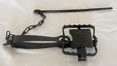
During the Great Depression from 1929 to 1932, rabbit trapping was a means of survival for many people. Rabbits provided meat and pelts which were sold for making felt hats such as the Akubra. Rabbit populations are controlled in the 21st century by poisoning, destroying or 'ripping' burrows (warrens), biological control with rabbit haemorrhagic disease and myxomatosis, and by shooting. Rabbit-proof fences also prevent the spread of rabbits into some areas. (ref. Powerhouse Museum) Steel-jawed rabbit traps were widely used in urban and rural Australia from 1880 to 1980. This trap is symbolic of the battle that Australians have waged against burgeoning rabbit populations for over a century. Rabbits cause enormous damage to Australian soils and biodiversity. The introduction of rabbits to this country was an environmental disaster.Two iron rabbit traps. Each consists of a pair of jaws held closed by spring tension and a triggering mechanism. When the trap is triggered the jaws close over the top of the bridge, plate and tongue mechanism that is designed to trigger the trap. A chain is attached by a hook on the bent end of the trap's spring with a long steel spike looped over the last link of the other end of the chain. The trap is designed so that the metal jaws snap shut against each other when the trap is activated by the application of weight to the pressure plate. In use, traps are set with open jaws, buried lightly just below the surface of the earth. When an animal steps on the pressure plate, the jagged teeth of the jaws snap around the animal's leg, usually breaking bone and sinew. Thus the animal is immobilised.rabbits rural trapping -
 Orbost & District Historical Society
postcard, C1920-1940
This photograph shows the second major bridge across the Snowy River at Orbost. The current Snowy River bridge is the fourth to provide a crossing to the township of Orbost. The first, in 1891, lasted just two years before it succumbed to flood waters. The bridge in this photograph was built in the 1920s as a road and rail bridge, and was again partly washed away by flood waters in 1934. After the end of the first World War the Victorian Railways considered an extension of the railhead across the river at Orbost, and in 1922 a new timber and steel girder structure, a joint Country Roads Board — Victorian Railways venture, was built and completed at a cost of £41,000 (the steel girders came from the Flinders Street viaduct reconstruction). Subsequently it was decided not to take the railway across the river, and the bridge was only used by road traffic. It was severely battered by floods during its life. and after the 1971 floods was eventually replaced by the current bridge in 1975. (info from Newletter 54N by John Phillips) This item is an early pictorial record of the previous Snowy River bridge at Orbost.A postcard with a black / white photograph of a bridge - timber and steel girder structure - across the Snowy River at Orbost, Reflections of the bridge are seen in the water.snowy-river-bridge-orbost -
 Orbost & District Historical Society
postcard, Vogt. W.S, first half 20th century
This photograph is of a train on the small rail bridge which crosses over the Burn Road Newmerella cutting. In 1912 work was underway to complete the Bairnsdale to Orbost section of the railway. This meant the end of river transport for the area. The railway was opened on April 10 1916 and closed in 1987. The letter written on the card is from Hilda Graham to her uncle.This item is associated with the history of the Orbost-Bairnsdale railway line and therefore reflects the role that the rail line played in the social and economic history of Orbost.A black / white postcard photograph showing a train engine crossing on a small rail bridge. On the back is a handwritten letter.Photo caption - "NEWMERELLA RAILWAY, ORBOST STANLEY VOGT"newmerella east-gippsland-railway -
 Orbost & District Historical Society
black and white photograph, Vogt. W.S, first half 20th century
... railway. It was opened on April 10 1916. The two bridges... railway. It was opened on April 10 1916. The two bridges ...In 1912 work was underrway on the Bairnsdale to Orbost railway. It was opened on April 10 1916. The two bridges on the railway viaduct, which crosses the Snowy River floodplain at Orbost, were built from local Southern Mahogany. The bridge on the Bairnsdale end (770m) is now the longest in Victoria. (info. Helen Martin)This item is associated with the history of the Orbost-Bairnsdale railway line and therefore reflects the role that the rail line played in the social and economic history of Orbost.A black / white photograph, oval-shaped on white background. It is of the railway viaduct across the flats at Orbost,.photo caption -"ORBOST RAILWAY BRIDGE, NEWMERELLA E. S. Vogt, Bairnsdale"newmerella orbost-viaduct east-gipsland-railway -
 Orbost & District Historical Society
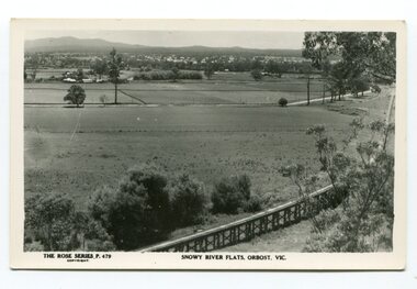
black and white photograph, Rose Stereograph Company, first half 20th century
... Mahogany. The bridge on the Bairnsdale end (770m) is now... Mahogany. The bridge on the Bairnsdale end (770m) is now ...The two bridges on the railway viaduct, which crosses the Snowy River floodplain at Orbost, were built from local Southern Mahogany. The bridge on the Bairnsdale end (770m) is now the longest in Victoria. Despite various attempts to extend the line, the station stayed on the western side of the Snowy River. (info. Helen Martin)This item is associated with the history of the Orbost-Bairnsdale railway line and therefore reflects the role that the rail line played in the social and economic history of Orbost.A black / white photograph / postcard of the Orbost township in the background and the railway viaduct over the flats in the foreground.photo caption - The Rose Series P.479 copywright SNOWY RIVER FLATS, ORBOST, VIC"east-gippsland-railway orbost-viaduct -
 Orbost & District Historical Society
photograph / postcard, early 20th century
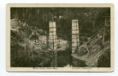
Boggy Creek Bridge was built in 1916 as part of the Bairnsdale to Orbost extension to the main Gippsland Railway, and is situated in the middle of the township of Nowa Nowa, crossing a steep-sided and well-timbered creek-valley. This section of the line closed in 1987.This item is a pictorial record of the construction of the Boggy Creek railway bridge on the East Gippsland line. This bridge plays a major part in the identity and history of the town of Nowa Nowa, since Boggy Creek’s steep sided valley divides the township into two components. A black / white photograph on a postcard showing the construction of a railway bridge across a creek. The end pylons are evident and there is scaffolding on both sides of the creek. Two copies of a black / white photograph showing the construction of a railway bridge across a cree. The end pylons are evident and there is scaffolding on both sides of the creek. There is a steam train on the rail track.on front of postcard - caption - " Boggy Creek, Nowa Nowa, W.S. Vogt, Bairnsdale"boggy-creek-bridge vogt-w.s. railway-bridges east-gippsland-railway railway-construction train -
 Orbost & District Historical Society
black and white photographs, Howard D. Bulmer, first half 20th century
This bridge was built in the 1920s as a road and rail bridge, and was partly washed away by flood waters in 1934. After the end of the first World War the Victorian Railways considered an extension of the railhead across the river at Orbost, and in 1922 a new timber and steel girder structure, a joint Country Roads Board — Victorian Railways venture, was built and completed at a cost of £41,000 (the steel girders came from the Flinders Street viaduct reconstruction). Subsequently it was decided not to take the railway across the river, and the bridge has only been used by road traffic. This is a pictorial record of an early bridge across the Snowy River at Orbost.A large black / white photograph of the Orbost Snowy River bridge. There is a large copy as well as a postcard copy in sepia.on front - Snowy River Bridge Orbost H.D. Bulmer - photo - Lake Tyers.snowy-river-bridge-orbost -
 Orbost & District Historical Society
black and white photograph, 1971
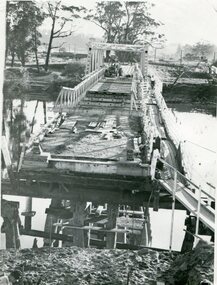
This photograph shows the second major bridge across the Snowy River at Orbost. The current Snowy River bridge is the fourth to provide a crossing to the township of Orbost. The first, in 1891, lasted just two years before it succumbed to flood waters. The bridge in this photograph was built in the 1920s as a road and rail bridge, and was again partly washed away by flood waters in 1934. After the end of the first World War the Victorian Railways considered an extension of the railhead across the river at Orbost, and in 1922 a new timber and steel girder structure, a joint Country Roads Board — Victorian Railways venture, was built and completed at a cost of £41,000 (the steel girders came from the Flinders Street viaduct reconstruction). Subsequently it was decided not to take the railway across the river, and the bridge was only used by road traffic. It was severely battered by floods during its life. and after the devastating 1971 floods was eventually replaced by the current bridge in 1975. (info from Newletter 54N by John Phillips)This is a pictorial record of the flood damage in 1971 when part of the Snowy River Bridge was washed away.A black / white photograph of a bridge which has been damaged by floodwaters. It shows one end has been washed away.orbost-snowy-river-bridge-1971 floods-orbost-1971 -
 Orbost & District Historical Society
rabbit trap, first half 20th century
During the Great Depression from 1929 to 1932, rabbit trapping was a means of survival for many people. Rabbits provided meat and pelts which were sold for making felt hats such as the Akubra. Rabbit populations are controlled in the 21st century by poisoning, destroying or 'ripping' burrows (warrens), biological control with rabbit haemorrhagic disease and myxomatosis, and by shooting. Rabbit-proof fences also prevent the spread of rabbits into some areas. (ref. Powerhouse Museum) This trap was used in the Orbost district. Steel-jawed rabbit traps were widely used in urban and rural Australia from 1880 to 1980. This trap is symbolic of the battle that Australians have waged against burgeoning rabbit populations for over a century. Rabbits cause enormous damage to Australian soils and biodiversity. The introduction of rabbits to this country was an environmental disaster.A rusted iron rabbit trap which consists of a pair of jaws held closed by spring tension and a triggering mechanism. When the trap is triggered the jaws close over the top of the bridge, plate and tongue mechanism that is designed to trigger the trap. A chain is attached by a hook on the bent end of the trap's spring with a long steel spike looped over the last link of the other end of the chain. The trap is designed so that the metal jaws snap shut against each other when the trap is activated by the application of weight to the pressure plate. In use, traps are set with open jaws, buried lightly just below the surface of the earth. When an animal steps on the pressure plate, the jagged teeth of the jaws snap around the animal's leg, usually breaking bone and sinew. Thus the animal is immobilised. rabbit-trap rural -
 Orbost & District Historical Society
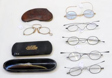
spectacles and spectacle cases, late 19th early 20th century
This collection of glasses and cases was donated by Miss Connie Cruickshank. She was part of the family of Orbost's first doctor, Dr James Kerr. As the 19th Century came to a close, more and more people wore their eyeglasses everyday. A popular style of inexpensive, everyday spectacles was the pince-nez. French for "pinch nose," the pince-nez was first developed in France circa 1840 and began to be imported after the 1850s. Pince-nez have no temples, but are fit snugly on the bridge of the nose. Pince- nez could be uncomfortable to wear and broke often from falling off the nose. These items demonstrate how glasses' styles have changed over time. One pair of pince-nez glasses and its brown leather case shaped to fit. One solid black wooden case with a small hinged door at one end. One blue/black case with the words A A Abotomey 14 Carpenter Street Middle Brighton in gold lettering. Five pairs of spectacles, one with blue coloured glass with crack in one lens.A A Abotomey 14 Carpenter Street, Middle Brightonspectacles spectacles-cases pinz-nez -
 Orbost & District Historical Society
black and white photograph, Howard D. Bulmer, first half 20th century
A new bridge over the Snowy River at Orbost was opened for traffic on June 20th 1922. It was intended as a road and rail bridge, and was again partly washed away by flood waters in 1934. After the end of the first World War the Victorian Railways considered an extension of the railhead across the river at Orbost, and in 1922 a new timber and steel girder structure, a joint Country Roads Board — Victorian Railways venture, was built and completed at a cost of £41,000 (the steel girders came from the Flinders Street viaduct reconstruction). Subsequently it was decided decided not to take the railway across the river, and the bridge was only used by road traffic. This is a pictorial record of an early bridge over the Snowy River at Orbost.A black / white postcard photograph of a bridge across a shallow river with men on horseback underneath.snowy-river-bridge -
 Orbost & District Historical Society
black and white photograph, first half 20th century
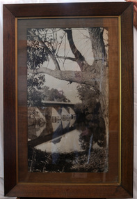
This is a bridge across the Snowy River at Orbost. This bridge was built in the 1920s as a road and rail bridge, and was partly washed away by flood waters in 1934. After the end of the first World War the Victorian Railways considered an extension of the railhead across the river at Orbost, and in 1922 a new timber and steel girder structure, a joint Country Roads Board — Victorian Railways venture, was built and completed at a cost of £41,000 (the steel girders came from the Flinders Street viaduct reconstruction). Subsequently it was decided not to take the railway across the river, and the bridge has only been used by road traffic.This is a pictorial record of an early bridge across the Snowy River at Orbost.A very large black / white photograph under glass in a timber frame. It is of a bridge across a river and is framed by trees.bridge snowy-river-bridge road-transport-orbost -
 Ringwood and District Historical Society
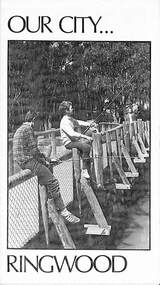
Pamphlet, Our City - Ringwood (1972), 1972
Community information brochure issued in 1972 by Ringwood Council outlining local services, sporting, and cultural facilities. Includes names of Ward Councillors, and two City of Ringwood Free Tipping Vouchers valid until the end of 1973."Frontpiece: New bridge of pressure treated pine over Ringwood Lake." "Ringwood Must Grow, Not Go! With your money, Council provides these vital Services."rinx -
 Upper Yarra Museum
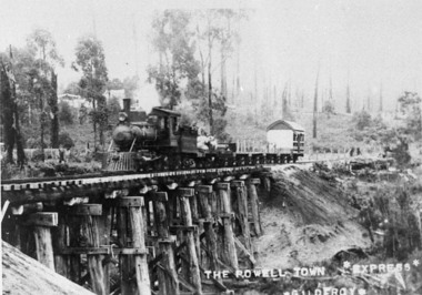
Negative Photographic Reproduction, Powelltown Express 1914 Gilderoy, 14.2.1983
The "Express" is pulled by the Little Yarra steam train, and is on a wooden trestle bridge crossing the Saxton creek at Gilderoy, the carriage on the end was for passengers, but it was only used for a short timePowelltown Express 1914 Gilderoy. Negative Black white Scanned at 600 dpi. trestle bridge tramway powelltown steam engine saxton creek gilderoy a ross -
 Bendigo Military Museum
Album - ALBUM, PHOTOGRAPH, Photo Album BCOF Association, c1945-1949
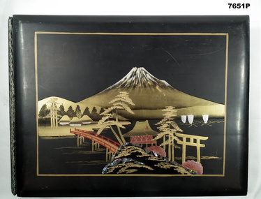
Item is part of the BCOF Association collection. Refer Cat No 7625This is a large photo album. The front and rear covers are made from wood. The basic colour is dark brown. On the front cover is painted a picture of Mt. Fuji, a Japanese village, a bridge and a small building on land, a tree and an archway. Colours are white, gold, red and mauve. It also has a very fine layer of reflective material - possible pearl shell. Inside are a large quantity of Aust soldiers in Japan - postwar. There are tourist type photos as well. Tokyo - Kure - Iwakuni. There are coloured postcards amongst the photos. It also has numerous scenes of Japanese civilian life. There are a few unused pages at the end of the album.ww2, japan, bcof -
 Warrnambool and District Historical Society Inc.
Instrument - Musical Instrument, Violin and stand, Early 20th Century
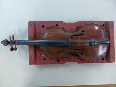
This violin was made by Mr Edward Richter who lived in Warrnambool for 78 of his 85 years. he was born 10/03/1853 and was an expert model maker making models of ships. The Warrnambool Museum in 1937 held a model of the Cutty Sark which he had made from timber from the wreck of the Enterprise which was wrecked on Warrnambool beach. Violins were another of of his hobbies.This violin has a connection to Warrnambool through the maker who was a long time resident of the town. It belongs to an era when many people were interested in and turned their hand to making objects such as this.The body of the violin is stained brown in colour with black neck and bridge. The four strings are nylon. The pegs and scroll are timber of a finer grain than the front and back.The tailpiece and end button are black material. The bridge is missing. The stand is rectangular with violin shape cutout, painted in red with a ply backing. Small leather strap on one end. Six large and two small drilled holes around front section.Richter written in large letters on back of standwarrnambool, edward richter, handmade violin, richter warrnambool -
 Kiewa Valley Historical Society
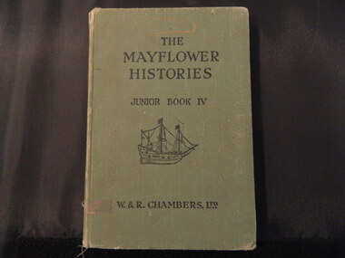
Book - History - Educational, The Mayflower Histories - Junior Book IV by Thomas Kelly MA
School books were bought and stored in the school library for teachers' use. This has Questions and Exercises at the end of each chapter. its aim is to give children in the junior school an understanding and knowledge of history.This book was part of the Mongan's Bridge and later the Tawonga State Schools libraries. It is an example of teaching subjects and methods in the early 1950s.Greenish book with black title and picture of a sailing boat on the front thick cardboard cover. 192 pages. Black and white drawings and photos. Library sleeve and slip inside back cover.Written in pen "State School ' Mongans Bridge" Ink stamp "State School / No. 2282 / Tawonga Library book with 911 / KEL sticker on back.mongan's bridge, tawonga state school, kiewa valley, library -
 Kiewa Valley Historical Society
Spectacles Reading, circa early 1900s
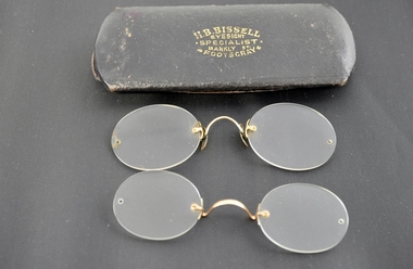
These reading glasses plus the two additional replacement lenses were highly fashionable in the late 1800's and early 1900's due to their light frames ie. wire. They are of light material and are not as obtrusive, or heavy, as horn rimmed reading glasses.This minimisation of the eye wear was to allow the facial features to be presented without any obstructing eye wear, "au naturel". The "light weight" wire connections to nose and ears was to minimise weight upon those physical areas. It was an eye piece preferred by accountants and all forms of "book worms". This was a period when the "written word" was at its peak. This was well before the light enhanced computer screen and at an age where the "written word" was in the majority as compared to the typed word. These reading glasses are very significant to the Kiewa Valley as they provide additional material which supports the "isolational factors" which were prevalent in the 1800's and early 1900's. Poor lighting and lack of available optical technicians in rural areas, required those suffering with eye troubles in these rural areas to go to Melbourne. An advertisement placed by H B Bissel "eyesight specialist" in the "Independent" Newspaper in 1915 on page 3 " Every person's eyes are liable to be affected by some little weakness or other and these weaknesses, if not corrected at once, are apt to assume a most serious aspect as time goes on". This type of advertisement is putting "the fear of God" on those with slight eyesight problems. It also does not factor the poor lighting used by most in rural areas at this point in time. By the mid to late 1950's, electricity in the Kiewa Valley was available to all households and improved lighting helped nighttime readers. These reading glasses, made in Melbourne, highlight the fact that the Kiewa Valley and its region were still reliant on Melbourne based "specialists" and travel to and from these highly professional health practitioners not only involved a long, and time consuming journey, but also an expensive one.The frames of this oval wire reading glasses is made from gold plated copper wire. There are three nose bridges each with a slightly different angle and shape, each has a different magnification. This may suggest that they were in use at different developmental periods during the wearers ages. Each of the three lenses were fixed onto the frame by a screw and fastened directly onto the glass. Two of the glasses have nose "guides/rests" and one without.. The fine wire ear "loops" has a small "ball" feature at its end (to stop the glasses from slipping off the face).personal effects, spectacles, eye fashion, reading glasses -
 Kiewa Valley Historical Society
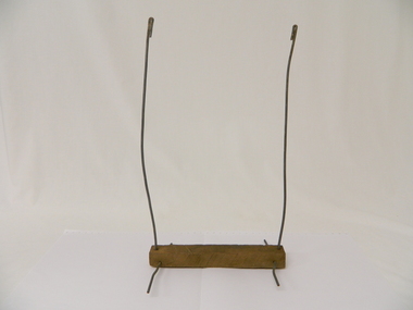
Tobacco Grading Dividers x 6, 1962
Tobacco farming began circa 1960 in the Kiewa Valley and consequently became one of its major industries. Many of the Italian families were involved in tobacco farming.Historical: This equipment was used on one of the first tobacco farms in the Kiewa Valley at Mongans Bridge. The dividers were home-made showing the resourcefulness of farmers living in the Kiewa Valley. Provenance: This tobacco farmer came from Italy and was sponsored to visit a tobacco farmer in Myrtleford to learn how to grow tobacco so that he could transfer those skills to his own farm in the Kiewa Valley.Wood plank with wire attached through a hole at each end in from side edge to create a stand. Another piece of wire stands vertically and is folded over to create blunt edge at the top. At the bottom it goes through the wood and along a bit to hold the wire in place. There are 6 dividers and because they are handmade the measurements vary slightly. tobacco. kiewa valley. mongans bridge. parmeson. rossaro, lorenzi brothers. grading dividers. -
 Kiewa Valley Historical Society
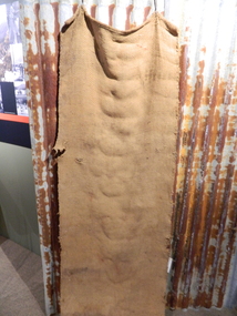
Tobacco Picking Bag
Tobacco farming began circa 1960 in the Kiewa Valley and consequently became one of its major industries. Many of the Italian families were involved in tobacco farming.Historical: This equipment was used on one of the first tobacco farms in the Kiewa Valley at Mongans Bridge. The picking bag was home-made showing the resourcefulness of farmers living in the Kiewa Valley. Provenance: This tobacco farmer came from Italy and was sponsored to visit a tobacco farmer in Myrtleford to learn how to grow tobacco so that he could transfer those skills to his own farm in the Kiewa Valley.Picking bag known as 'Sacco'. The bag was used as a liner to the collecting bin in front of each of the 4 pickers on the picking machine. The bag was then hooked closed and held the leaf together for transport to the shed. Brown hessian woven length with 2 thick wires at 1 end hooked through 'bag' 100 mm from each side and hook on other end. Shaped in 1 rectangle rather than like a bag.Edges rough with wear and tear. A couple of holes where weave in 1 direction has torn.tobacco. picking bag. mongans bridge. kiewa valley. sacco. parmesan. rossaro. lorenzi brothers.