Showing 876 items matching "evelyn"
-
 Eltham District Historical Society Inc
Book, Warrandyte Historical Society, Letters Home: Boer War 1900-1901, World War I 1916 (extracts from The Evelyn Observer reproduced by Warrandyte Historical Society)
... Letters Home: Boer War 1900-1901, World War I 1916 (extracts from The Evelyn Observer reproduced by Warrandyte Historical Society)...Copies of newspaper articles copied from "The Evelyn Observer" with dates. Includes some news reports but mostly letters from soldiers. ...Capewell (Eltham) evelyn observer boer war letters world war 1 Various un-numbered pages held in place housed in yellow folder. ...Copies of newspaper articles copied from "The Evelyn Observer" with dates. Includes some news reports but mostly letters from soldiers. Names include W. J. Beard of Research E. Andrew of Eltham Private S. Harris (Kangaroo Ground, Queenstown and Kinglake) E. Payne (Whittlesea) W Reid of (Hazelglen) W. J. Capewell (Eltham)Various un-numbered pages held in place housed in yellow folder. Photo of soldier on a horse on the cover. No caption but probably Private/Trooper Shelley Harris of Kinglake, Bushmen's Corp. Boer Warevelyn observer, boer war, letters, world war 1 -
 Eltham District Historical Society Inc
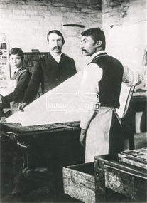
Photograph, L-R: John Edward Greenaway (apprentice), R. C. Harris (editor) and James Foggie in the Printing Office of the Evelyn Observer, Kangaroo Ground in the 1880s
... Harris (editor) and James Foggie in the Printing Office of the Evelyn Observer, Kangaroo Ground in the 1880s....The Printing office of the 'Evelyn Observer' at Kangaroo Ground operated from about 1872 until it became the 'Advertiser' and moved to Hurstbridge during the 1914-1918 war. ...Harris (editor) and James Foggie in the Printing Office of the Evelyn Observer, Kangaroo Ground in the 1880s. ...Reproduced on p40 of 'Pioneers & Painters' Mr Robert Harris (centre) was associated with the paper for forty-seven years. The Printing office of the 'Evelyn Observer' at Kangaroo Ground operated from about 1872 until it became the 'Advertiser' and moved to Hurstbridge during the 1914-1918 war. The building was then used as Shire Office, later destroyed by fire 8 Feb. 1934. Source: Mrs. McMinn, KinglakeThis photo forms part of a collection of photographs gathered by the Shire of Eltham for their centenary project book,"Pioneers and Painters: 100 years of the Shire of Eltham" by Alan Marshall (1971). The collection of over 500 images is held in partnership between Eltham District Historical Society and Yarra Plenty Regional Library (Eltham Library) and is now formally known as the 'The Shire of Eltham Pioneers Photograph Collection.' It is significant in being the first community sourced collection representing the places and people of the Shire's first one hundred years.Digital imageevelyn observer, james foggie, john edward greenaway, kangaroo ground, newspapers, pioneers and painters, printing, r.c harris, sepp, shire of eltham pioneers photograph collection -
 Eltham District Historical Society Inc
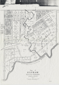
Document - Map, Victoria. Department of Crown Lands and Survey, Town of Eltham, Parish of Nillumbik, County of Evelyn, 2 October 1929
... Town of Eltham, Parish of Nillumbik, County of Evelyn...Township of Eltham, Parish of Nillumbik, County of Evelyn / lithographed at the Department of Lands & Survey Melbourne 5th June 1888, amended 2 October 1929 This amendment from the 1888 original shows the reserve for the the State School marked as permanent with dimensions added to Main Road and block frontages along Main Road between Mount Pleasant Road and Dalton Street and Metery Road Possibly photocopied from a copy held at PROV by Harry Gilham whilst resaerching Eltham Primary School history in 1995....Schultz William Thomas Eltham Primary School Eltham State School Eltham State School No. 209 Quarry Reserve A3 size photocopy Town of Eltham, Parish of Nillumbik, County of Evelyn Document Map Victoria. Department of Crown Lands and Survey ...Township of Eltham, Parish of Nillumbik, County of Evelyn / lithographed at the Department of Lands & Survey Melbourne 5th June 1888, amended 2 October 1929 This amendment from the 1888 original shows the reserve for the the State School marked as permanent with dimensions added to Main Road and block frontages along Main Road between Mount Pleasant Road and Dalton Street and Metery Road Possibly photocopied from a copy held at PROV by Harry Gilham whilst resaerching Eltham Primary School history in 1995.a. armstrong, a. lavard, arthur c. allan, arthur c. allen, b. bowatere, baxter street, benjamin oliver wallis, bolton steet, c. souter, c.s. hain, cemetery reserve, charles brown, charles newman, charles symons wingrove, christopher caldwell, church of england, d. anderson, dalton street, david ballard, e. james, e.m. peck, edward dumaresq, eltham town, ely street, f.e. falkiner, f.m. peck, falkiner street, flint street, g. buckingham, g. drabble, george stebbing, godalmin street, h. peck, h.c.whess, h.h. farquharson, h.j. bews, henry stooke, j. goer, j. mcdonald, j. mclaren, j. roberts, j.b. knagers, james irish, jane bailey (nee matthews), john l. smith, john mason, john scott, john smith, joseph stevenson, joseph verse, k. wingrove, k.e. dunstan, kerby street, kirby street, location tbd, m. coman, map, michael o'shea, o.b. mccutcheon, p. & g. tumbull, p.k. mccaughan, p.p. cotter, porter street, pound reserve, robert hepburn, roman catholic church, s. evans, samuel dagley, samuel phillips, samuel ramsden, t. upton, t. watkins, t.a. stark, t.c.b. batt, t.p. cross, thomas grant, thornton street, w. adam, w. blain, w. long, w. watkins, w.f. ford, w.h. hull, w.r. belcher, w.t. schultz, william thomas, eltham primary school, eltham state school, eltham state school no. 209, quarry reserve -
 Mont De Lancey
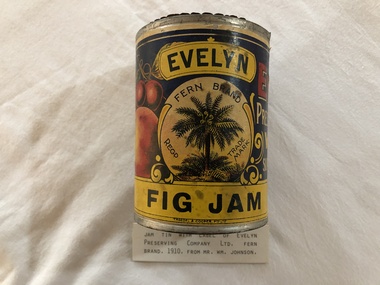
Tin, 1910
... Jam tin with label of Evelyn Preserving Company Ltd, Wandin. ...Evelyn Fig Jam/ Fern Brand Regd Trade Mark...Mont De Lancey 71 Wellington Road Wandin North yarra-valley-and-dandenong-ranges jam containers food storage cans Evelyn Fig Jam/ Fern Brand Regd Trade Mark Jam tin with label of Evelyn Preserving Company Ltd, Wandin. ...Jam tin with label of Evelyn Preserving Company Ltd, Wandin. Evelyn Fig Jam/ Fern Brand Regd Trade Markjam containers, food storage cans -
 Eltham District Historical Society Inc
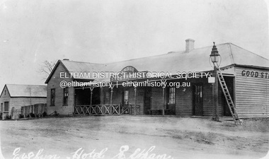
Photograph, Evelyn Hotel, Eltham, c.1892
... Evelyn Hotel, Eltham...Postcard image of W. Morris Evelyn Hotel, cnr. Main Road and Pitt Street, Eltham, opposite present hotel. ...Postcard image of W. Morris Evelyn Hotel, cnr. Main Road and Pitt Street, Eltham, opposite present hotel. ...Postcard image of W. Morris Evelyn Hotel, cnr. Main Road and Pitt Street, Eltham, opposite present hotel. Built in 1852 as the Fountain of Friendship Hotel, later named the Fountain Hotel it was located on the southwest corner of Maria (Main) and Pitt streets. Also later known as the Evelyn Hotel, it was de-licensed in 1919. The hotel was totally destroyed by fire on Wednesday, February 18, 1931 Sometime between June 1851 and 1854, the property at the top of the hill of Little Eltham described as Lot 235 of plan of subdivision, of portion number 12, of section number 4, of the parish of Nillumbik, on the county of Evelyn was purchased from J.M. Holloway and the Fountain of Friendship Hotel was built using prefabricated sections constructed from cedar timber, imported from Singapore. By 1854, John O’Brien, a somewhat shady character was the proprietor of the hotel when he put it up for sale in November 1854. It is not clear whether he was the original owner / builder. John O’Brien purchased several other lots in Little Eltham from a Robert Wells but did not pay the balance for these lots and skipped town as soon as he sold the Fountain Hotel to Charles Roberts. Following the somewhat dodgy business practices of John O’Brien, little is known of Charles Roberts but it is possible he enjoyed several years of ownership. It was put up for sale again in 1858 but no outcome of that sale is known, and it was advertised to let in 1863, again possibly to no avail. James Trew took it over in July 1864 but his association was short lived with his premature death in December of that year leaving his widow Mary to take over and run the enterprise. No other details regarding ownership or issuances of licenses to run a public house have been identified so it is possible that Mary Trew managed the business until it was eventually advertised To Let in December 1870. George Merrick took over the hotel and was granted a license at the end of March 1871 but he too was destined to follow in the footsteps of James Trew and died prematurely at age 40 just six months later, in September 1871. John Treloar then took over the hotel but sometime between 1872 and 1873 the license was transferred to Bejamin Gane. Gane it seems held the license for the majority of the 1870s At some point between December 1874 and September 1878 the name of the hotel is changed from the Fountain Hotel to the Evelyn Hotel. In March 1880, ownership is transferred to James Purcell, a former Councillor of the Shire of Eltham’s North Riding. Purcell’s ownership of the hotel is associated with the 1880s though there is a brief period in 1887 where the license is granted to a Lawrence Brennan, reasons unknown. In December 1889, James Purcell ownership of the Evelyn hotel throughout the 1880s comes to an end when William Morris purchases the property and the license is transferred to him. Ownership of the property remains within the Morris family for the next 40 plus years and it is the Morris name that is most associated with its history. William Morris was a Councillor with the Shire of Eltham for a continuous 24 year period. He served as Shire President for three terms. It appears he did very well with the Evelyn Hotel and his entertainment and dining experiences are well regarded. Morris is also closely asspotaieted with local horse racing events and often provided the hospitality for the Diamond Creek races and various races held at Eltham Park (Eltham Lower Park). It is during Morris’ stewardship that major changes occurred to the hotel. On June 2, 1892 a fire broke out in one of the lodger’s rooms from a candle that had been left burning. The hotel is constructed of timber and three rooms are destroyed. Christopher Watson, proprietor of the Eltham Hotel across the road comes to Morris’ assistance and the hotel is saved but there is significant damage. It is suspected that the lodgers rooms were at the southern end of the building in the two-story section. It is further suspected that it is a result of this fire that the building was modified and the two story section rebuilt as single story and the shingle roof converted to tin. From this point on, Morris appears to enjoy a relatively long and quiet period of ownership. He signs a 5 year lease to let the hotel out in 1903 and the license is transferred to an Ann Evans. Morris intended to live in a house near the railway station but the license ris renewed in his name just two years later in December 1905. Morris is charged with illegal Sunday trading in August 1917. The case is dismissed through lack of evidence. It seems that this was fairly commonplace amongst the various hostelries of the countryside. In June 1919 the Evelyn Hotel is de-licensed. Though considered clean and well maintained, the Licensing Board did not believe having two hotels directly opposite each other was warranted for the existing trade. The case for the Eltham Hotel to remain in business was stronger. Morris was subsequently awarded £480 in November of that year as compensation. The property then was used for various businesses such as hairdressing and dining rooms as well as lodging. William Morris died in December 1922 and his wife Mary inherited the property. She had listed it for sale in August 1929 but nothing eventuated from that. In February 1931, whilst occupied by Hector and Louise McLean and their young family, the old building caught fire. Ashes from one of the fires had fallen through the cracks in the floorboards and took hold in the basement. A firsthand account of that harrowing experience was recorded by Mrs Edith Jones (nee McLean) in 1998, who was six years old at the time, and held by Eltham District Historical Society (04749). It was published in EDHS Newsletter No. 226, October 2022. On July 3, 1931 the Advertiser published the following endnote to the Evelyn Hotel. Last Traces of Fire The traces of Eltham's largest fire are being obliterated by the removal of debris from the site of the old Evelyn Hotel, which was destroyed a few months ago, and all that now remains is a blackened spot and fire colored bricks and stones. The site is one of the most imposing in the district, being in the heart of the old township. The township is really in two sections, old and new, the latter is situated round the station. The passing of the old hotel was regretted by all, as it was so closely associated with the pioneering, days.Postcard photoRetun to Garnet Burges c/o Judge Bookhotels, evelyn hotel, eltham, main road, pitt street, fountain hotel, william morris -
 Ringwood and District Historical Society
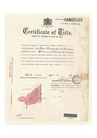
Document, Certificate of Title - Crown Sections 12, 15, and Part of Section 20 (later including Warranwood, Vic.), Parish of Warrandyte, County of Evelyn - 11 June, 1898
... Certificate of Title - Crown Sections 12, 15, and Part of Section 20 (later including Warranwood, Vic.), Parish of Warrandyte, County of Evelyn - 11 June, 1898....The Mutual Assurance Society of Victoria Limited of 406 Collins Street Melbourne, County of Bourke, is now the proprietor of an Estate in Fee-simple - 1,640 acres 3 roods 31 perches or thereabouts, being Crown Sections 12, 15, and part of Crown Section 20, Parish of Warrandyte, County of Evelyn. TRANSFER - 13th March, 1899 - 17ac 3rds 5per to The President Councellors and Ratepayers of the Shire of Lilydale (Part of Crown Section 20)....Certificate of Title - Crown Sections 12, 15, and Part of Section 20 (later including Warranwood, Vic.), Parish of Warrandyte, County of Evelyn - 11 June, 1898. Document ...A4 copies of Landata Victoria Historical Search documents - Vol 2687 Fol 537231.The Mutual Assurance Society of Victoria Limited of 406 Collins Street Melbourne, County of Bourke, is now the proprietor of an Estate in Fee-simple - 1,640 acres 3 roods 31 perches or thereabouts, being Crown Sections 12, 15, and part of Crown Section 20, Parish of Warrandyte, County of Evelyn. TRANSFER - 13th March, 1899 - 17ac 3rds 5per to The President Councellors and Ratepayers of the Shire of Lilydale (Part of Crown Section 20). -
 Ringwood and District Historical Society
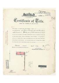
Document, Certificate of Title - Crown Allotments 4A, 4B, 11A, 11B, and Crown Sections 5 and 6 (later including Wonga Park, Vic.), Parish of Warrandyte, County of Evelyn - 17 June, 1895
... Certificate of Title - Crown Allotments 4A, 4B, 11A, 11B, and Crown Sections 5 and 6 (later including Wonga Park, Vic.), Parish of Warrandyte, County of Evelyn - 17 June, 1895....Frederick Walter Purches of Ascot Vale, Wholesale Butcher, is now the proprietor of an Estate in Fee-simple - 2,291 acres 3 roods 24 perches or thereabouts, being Crown Allotments 4A, 4B, 11A, 11B, and Crown Sections 5 and 6, Parish of Warrandyte, County of Evelyn. Transfers include The Mutual Assurance Society of Victoria Limited, 15th August, 1896, The President Councellors and Ratepayers of the Shire of Lilydale, 13th March, 1899....Certificate of Title - Crown Allotments 4A, 4B, 11A, 11B, and Crown Sections 5 and 6 (later including Wonga Park, Vic.), Parish of Warrandyte, County of Evelyn - 17 June, 1895. Document ...A4 copies of Landata Victoria Historical Search documents - Vol 2574 Fol 514725.Frederick Walter Purches of Ascot Vale, Wholesale Butcher, is now the proprietor of an Estate in Fee-simple - 2,291 acres 3 roods 24 perches or thereabouts, being Crown Allotments 4A, 4B, 11A, 11B, and Crown Sections 5 and 6, Parish of Warrandyte, County of Evelyn. Transfers include The Mutual Assurance Society of Victoria Limited, 15th August, 1896, The President Councellors and Ratepayers of the Shire of Lilydale, 13th March, 1899. -
 Ithacan Historical Society
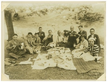
Photograph, Ithacan picnic, c 1930s
... The group of friends and families are enjoying a picnic which was held at Mt Evelyn and organised by the Ithacan Philanthropic Society some time in the late 1930s. ...Mount Evelyn, Victoria, Australia...Ithacan Historical Society Ithaca House 329 Elizabeth Street Melbourne melbourne The group of friends and families are enjoying a picnic which was held at Mt Evelyn and organised by the Ithacan Philanthropic Society some time in the late 1930s. ...The group of friends and families are enjoying a picnic which was held at Mt Evelyn and organised by the Ithacan Philanthropic Society some time in the late 1930s. Pictured L-R Stathis Troholis, Nicholas Trohoulias, Gerry Rigos (Varvarigos), Peter Drakopoulos, Irakli Regos, Stathis Benias, Angelo Zafiris, Odyssea (Des) Kostopoulos, Spiro Troholis, Helen Regos, unknown. A sepia photograph in a white cardboard folder of nine men and two ladies sitting on the ground around a picnic meal spread out in front of them . The names of the people in the photograph have been written on the back of the folder. -
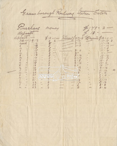 Eltham District Historical Society Inc
Document - Folder, Greensborough Railway Station Estate, Lots 26, 26A and 26B, Crown Portion 3, Parish of Nillumbik, County of Evelyn (Rattray Road, Montmorency)
... Greensborough Railway Station Estate, Lots 26, 26A and 26B, Crown Portion 3, Parish of Nillumbik, County of Evelyn (Rattray Road, Montmorency)...Crown Portion 3 of Eltham, Parish of Nillumbik, County of Evelyn, Lots 26, 26A and 26B were part of the Greensborough Railway Station Estate. ...Eltham District Historical Society Inc 728 Main Rd Eltham melbourne Crown Portion 3 of Eltham, Parish of Nillumbik, County of Evelyn, Lots 26, 26A and 26B were part of the Greensborough Railway Station Estate. ...Crown Portion 3 of Eltham, Parish of Nillumbik, County of Evelyn, Lots 26, 26A and 26B were part of the Greensborough Railway Station Estate. The land detailed is bounded by present-day Rattray Road, Reichelt Avenue, Wooded Way and Ryrie Court, Montmorency. Originally purchased in September 1913 by George William Miller, signwriter of Greensborough and Harry Frederick Miller, the land was sold to Mrs Margaret Barr Honeyman, 24 June 1918 on mortgage for £400, deposit paid £150. In February 1920, Mr Honeyman called for the title and paid off the loan early, settlement occuring 11 October 1920. Contents: 1. Handwritten payment plan (Sep 1913 to Mar 1923) for Lots 26, 26A and 26B being parts of Crown Portion 3, Parish of Nillumbik, County of Evelyn on the plan of subdivision making up the Greensborough Railway Station Estate situated on Rattray Road; purchased for £179.2.0 with a deposit of £18.0.0. 2. Receipt: From Messrs G.W. and H.F. Miller for £11.15.8 being instalment and interest, 9 Sep 1913 3. Invoice: To Messrs G.W. and H.F. Miller for £11.12.0 being instalment and interest due 15 Sep 1914 4. Contract of Sale: George William Miller and Harry Frederick Miller to Mrs. Margaret Barr Honeyman, in respect of sale of Lots 26, 26A and 26B for £400.0.0, 24 June 1918. Deposit of £150.0.0 balance to be paid half yearly instalments of £15 with interest at 5% per annum added. 5. Letter: Percy J. Russell, Solicitor to G.W. Miller, 5 Feb 1920 advising Mr Honeyman has called for the title and wishes to pay off mortgage. 6. Letter: Percy J. Russell, Solicitor to G.W. Miller, 11 Oct 1920 advising settlement and payment of Miller to Honeyman.contract of sale, george william miller, greensborough railway station estate, harry frederick miller, land sale, margaret barr honeyman, montmorency, rattray road, reichelt avenue, ryrie court, wooded way -
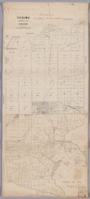 Yarra Ranges Regional Museum
Map, District of Yering, 1 Dec 1885
... Evelyn...Canvas backed paper map of District of Yering, Country of Evelyn, showing proposed waterworks for township of Lilydale. ...Canvas backed paper map of District of Yering, Country of Evelyn, showing proposed waterworks for township of Lilydale. ...Proposed water main shown with of reservoir etc. Evelyn Lilydale Waterworks and irrigation Canvas backed paper map of District of Yering, Country of Evelyn, showing proposed waterworks for township of Lilydale. ...Canvas backed paper map of District of Yering, Country of Evelyn, showing proposed waterworks for township of Lilydale. Signed by Hodgson & Smith, water supply engineers. Proposed waterworks for the township of Lilydale. Signed by Hodgson & Smith, water supply engineers. Proposed water main shown with of reservoir etc. Canvas backed paper map of District of Yering, Country of Evelyn, showing proposed waterworks for township of Lilydale. Signed by Hodgson & Smith, water supply engineers. Proposed waterworks for the township of Lilydale. Signed by Hodgson & Smith, water supply engineers. Proposed water main shown with of reservoir etc. evelyn, lilydale, waterworks and irrigation -
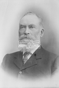 Eltham District Historical Society Inc
Photograph, The Hon. Ewen Hugh Cameron, Member for Evelyn in Legislative Assembly, Victorian Parliament, for 40 years from 1874-1914
... Ewen Hugh Cameron, Member for Evelyn in Legislative Assembly, Victorian Parliament, for 40 years from 1874-1914...In 1874 Cameron was elected as the Member for Evelyn in the Victorian Legislative Assembly and held the seat until he retired in 1914 as “Father of the House”. ...Ewen Hugh Cameron, Member for Evelyn in Legislative Assembly, Victorian Parliament, for 40 years from 1874-1914 Photograph ...Ewen Hugh Cameron (1831- 27 September 1915) was born at Kilmonivaig, Inverness Scotland. He migrated to Melbourne in “The Hurricane” in 1853 and in 1855 tried his luck at the newly-opened Andersons Creek Goldfield. Two years later he was appointed first postmaster at Warrandyte and ran the store there. In 1863 he took up the 100 acre farm “Pigeon Bank” at Kangaroo Ground where he lived until his death. In 1874 Cameron was elected as the Member for Evelyn in the Victorian Legislative Assembly and held the seat until he retired in 1914 as “Father of the House”. He held a number of ministerial and other important Parlimentary positions. The most notable was Chairman of the Railways Standing Committee, which was responsible for much of the Railway development in Victoria. Concurrently with his Parliamentary career, he was a member of the Eltham Roads Board and later Council for more than 50 years. In 1867 he married Agnes Bell, a daughter of Kangaroo Ground pioneers. They had eight sons and three daughters.This photo forms part of a collection of photographs gathered by the Shire of Eltham for their centenary project book, "Pioneers and Painters: 100 years of the Shire of Eltham" by Alan Marshall (1971). The collection of over 500 images is held in partnership between Eltham District Historical Society and Yarra Plenty Regional Library (Eltham Library) and is now formally known as the 'The Shire of Eltham Pioneers Photograph Collection.' It is significant in being the first community sourced collection representing the places and people of the Shire's first one hundred years.Digital imagesepp, shire of eltham pioneers photograph collection, kangaroo ground, e.h. cameron, member for evelyn, victorian parliament, legislative assembly, ewen cameron, ewen hugh cameron -
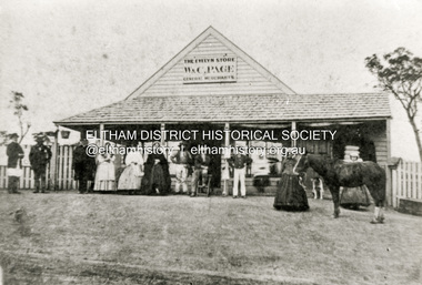 Eltham District Historical Society Inc
Photograph - Copy of photograph, The Evelyn Store, W. & C. Page, General Merchants, Little Eltham, located on northeast corner of Main Road and John Street, c.1865
... The Evelyn Store, W. & C. Page, General Merchants, Little Eltham, located on northeast corner of Main Road and John Street...W. and C. Page’s Evelyn Store was in the centre of the Eltham township in the 1860s. ...W. and C. Page’s Evelyn Store was in the centre of the Eltham township in the 1860s. ...W. and C. Page’s Evelyn Store was in the centre of the Eltham township in the 1860s. It was situated on the eastern side of Maria Street (Main Road) on what was Lot 355 of Josiah Holloway’s Plan of Subdivision of Little Eltham The property is described as having a frontage of one hundred and fifty one feet six inches to Maria-street by a depth of one hundred and thirty two feet with John Street on the south side. That property is now known as 816 Main Road and is occupied by Goodstart Early Learning Eltham. William Austin Page and Charlotte Moyses were married in the last quarter of 1840 in Wisbech, Cambridgeshire, England. Records of their arrival in Australia have not been found. The first record of W.A and C. Page, General Merchants is an advertisement placed in The Argus newspaper in February 1854 for The White Flag Store in Wellington Street, Collingwood. William Austin Page is next recorded in the 1856 Electoral Roll for Evelyn as a storekeeper of Little Eltham. The nature of his qualification being a dwelling house in Little Eltham. There is no C. Page recorded so it is likely that this is William’s wife. It is not known when the store was built, possibly at the direction of W. and C. Page but most likely circa 1855-1856. The Page’s previous business in 1854 being The White Flag Store in Wellington Street, Collingwood. On 21 April 1857, W.A. Page along with John Pearson, Richard Warren (owner of the Eltham Hotel), James Kiddle and Thomas Marland petitioned the Licensing Magistrates of the District of Heidelberg, seeking for better police protection for the district. They pointed out that Eltham had two hotels, a local population of about a thousand persons, a great number of them strangers employed on the public roads. The Bourke District police inspector investigated and recommended that the application be approved; and he advised the Chief Commissioner of the availability of a cottage (not very good) and a two-stalled stable with a fenced paddock of four acres, for the sum of ten shillings a week. This was William Jarrold' s cottage, on the west side of Main Road which became Eltham's first police station - with Constable George Reid in charge. In 1858 the newly established Eltham Road District Board implemented a rate charge. For the year ending October 14, 1858, William A. Page of Little Eltham was listed as the owner and occupier of a shop in Little Eltham, assessed 10 shillings based on building rate of 6d per £, the store valued at £20. The same was assessed for 1859 through 1861. The business was advertised for sale with four years remaining on the then present lease in October 1860. Apparently, there was a lack of interest as they attempted to sell the business again in September 1861 with three years remaining on the lease. Again, to no avail. No record of W.A. Page or the store appears in the 1862 rates assessment however in 1863 the store was valued at £25, owned by T. Hunniford and occupied by W.A. Page. Presumably Thomas Hunniford, purchased the property in 1862 and it may have been unoccupied for a period of time or the owner/occupier entries could have been transposed incorrectly in the rates book. In April 1863, William Austin Page, storekeeper of Little Eltham advertised his intention to have Lot 345 (sic) of Josiah Holloway’s Plan of Subdivision brought under the provisions of the Real Property Act. The property is described as having a frontage of one hundred and fifty one feet six inches to Maria-street by a depth of one hundred and thirty two feet with John Street on the south side. The actual lot described is Lot 355 and this is most likely the location of Page’s Evelyn Store. This action suggests the Pages remained owners of the property and this move was to facilitate a future sale. By September 1867 the Pages had been appointed official agents for The Leader newspaper. In January 1868 the business was once again put up for sale, the owners having been in business 12 years and desirous to return to England. Once more it did not sell and was offered again for sale in March and October of that year. Presumably businesses must have been difficult to sell in those times. No further evidence has been located so far of the Pages having sold their business, but an advertisement was placed in December 1870 offering the store and dwelling house for sale, presently occupied by the Pages. The property was finally sold January 28, 1871, by auction for £150. Whether the Pages ever did return to England, at least for a visit also has not been established but death records show William Austin Page died 12 April 1884 and his wife Charlotte died 4 August 1896. Both are buried in St Kilda Cemetery.Black and white copy of photographeltham, evelyn store, general merchants, general store, shops, w. & c. page, william austin page, charlotte page (nee moyses), little eltham -
 Whitehorse Historical Society Inc.
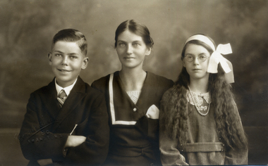
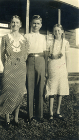
Photograph, Till Family
... ...evelyn...Sepia studio photograph of Evelyn Till with her children, Alwyn and Alison Till. ...Whitehorse Historical Society Inc. 2-10 Deep Creek Road Mitcham melbourne till alwyn evelyn alison bertha Sepia studio photograph of Evelyn Till with her children, Alwyn and Alison Till. ...Sepia studio photograph of Evelyn Till with her children, Alwyn and Alison Till. Alwyn in a suit, Evelyn with white strip on left of her dress, with large bow on hesd.till, alwyn, evelyn, alison bertha -
 Whitehorse Historical Society Inc.
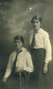
Photograph, Maggs sisters
... ...evelyn...Black & white studio photograph of Evelyn Maggs, seated, with her sister Harriet...Whitehorse Historical Society Inc. 2-10 Deep Creek Road Mitcham melbourne maggs harriet evelyn Black & white studio photograph of Evelyn Maggs, seated, with her sister Harriet Maggs sisters Photograph Photograph ...Black & white studio photograph of Evelyn Maggs, seated, with her sister Harrietmaggs, harriet, evelyn -
 Ringwood and District Historical Society
Document, Certificate of Title - Alexander William Brown - part of Crown Section 20, Parish of Warrandyte, County of Evelyn - 16th April, 1948
... Certificate of Title - Alexander William Brown - part of Crown Section 20, Parish of Warrandyte, County of Evelyn - 16th April, 1948....Brown includes: "Kardinia Crescent, Ringwood - Land containing 2 acres 3 roods 24-1/2 perches situate in Kardinia Crescent Ringwood being Lots 33 and 34 on Plan of Subdivision Number 12040 and being part of Crown Section 20 Parish of Warrandyte County of Evelyn and being the land described in Certificate of Title Volume 7141 Folio 080 valued by E. ...Certificate of Title - Alexander William Brown - part of Crown Section 20, Parish of Warrandyte, County of Evelyn - 16th April, 1948. Document ...A4 copies of Landata Victoria Historical Search documents - Vol 7141 Fol 1428080.Alexander William Brown of Grandview Grove (later Bemboka Road), Ringwood is now the proprietor of an Estate in Fee-simple subject to the Encumbrances notified hereunder ... 2 acres 3 roods 24 and one-half perches or thereabouts, being Lots 33 and 34 Kardinia Crescent, on Plan of Subdivision no.12040. Transfers include Alexander William Brown died 25th June, 1957, Probate granted 28th January, 1958, to Alfred Hart Brown of Dandenong, Estate Agent, and Harry Britten Elms of Cardinia, Gentleman, Oliver Burgess, Grandview Grove Ringwood, Florist - 14th May, 1964, Peter John Woodhead, Transport driver, and Shirley Margaret Woodhead, Married woman - 12th September, 1966. Inventory of Real Estate Assets (for Probate purposes 4/10/1957) detailed in Family Genealogy record for A.W. Brown includes: "Kardinia Crescent, Ringwood - Land containing 2 acres 3 roods 24-1/2 perches situate in Kardinia Crescent Ringwood being Lots 33 and 34 on Plan of Subdivision Number 12040 and being part of Crown Section 20 Parish of Warrandyte County of Evelyn and being the land described in Certificate of Title Volume 7141 Folio 080 valued by E. Miles at £350:0:0 -
 Ringwood and District Historical Society
Document, Certificate of Title - Leslie Mills of Plymouth Road, East Ringwood, Farmer - part of Crown Section 20, Parish of Warrandyte, County of Evelyn - 19th January, 1932
... Certificate of Title - Leslie Mills of Plymouth Road, East Ringwood, Farmer - part of Crown Section 20, Parish of Warrandyte, County of Evelyn - 19th January, 1932....Brown includes: "Grandview Grove, Ringwood Land containing 10 acres or thereabouts situate in Grandview Grove Ringwood being part of Crown Section 20 Parish of Warrandyte County of Evelyn and being the land described in Certificate of Title Volume 5781 Folio 174 on which is erected a 7 room house, a bungalow, shed and 2 glass houses valued by E. ...Certificate of Title - Leslie Mills of Plymouth Road, East Ringwood, Farmer - part of Crown Section 20, Parish of Warrandyte, County of Evelyn - 19th January, 1932. Document ...A4 copies of Landata Victoria Historical Search documents - Vol 5781 Fol 1156174.Leslie Mills is now the proprietor of an Estate in Fee-simple subject to the Encumbrances notified hereunder ... 10 acres or thereabouts, together with a right of carriage way over Grandview Grove (later Bemboka Road), Warranwood, Victroia. Transfers include Alexander William Brown of Tooradin, Farmer - 29th October, 1945, (died 25th June, 1957), Probate granted 28th January, 1958, to Alfred Hart Brown of Dandenong, Estate Agent, and Harry Britten Elms of Cardinia, Gentleman (*** See Probate details below) Oliver Burgess, Grandview Grove Ringwood, Florist - 14th May, 1964, Privatus Proprietary Limited, St.Kilda Road, Melbourne - 27th October, 1977, John Patrick Kelly, Company Director and Yvonne Gloria Kelly, Married Woman, joint proprietors, 10th September, 1980 *** Inventory of Real Estate Assets (for Probate purposes 4/10/1957) detailed in Family Genealogy record for A.W. Brown includes: "Grandview Grove, Ringwood Land containing 10 acres or thereabouts situate in Grandview Grove Ringwood being part of Crown Section 20 Parish of Warrandyte County of Evelyn and being the land described in Certificate of Title Volume 5781 Folio 174 on which is erected a 7 room house, a bungalow, shed and 2 glass houses valued by E. Miles, Ringwood - £5077-0-0 -
 Numurkah & District Historical Society
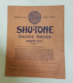
Shu-Tone Exercise Book
... First page has handwriting by owner (Evelyn Rose?) on first few pages. Back cover has arithmetic tables printed on it....Evelyn Rose / Herald Street...First page has handwriting by owner (Evelyn Rose?) on first few pages. Back cover has arithmetic tables printed on it. ...Exercise Book with advertising for Shu-tone Shoe Polish on the front cover (see photo). Lined pages inside. First page has handwriting by owner (Evelyn Rose?) on first few pages. Back cover has arithmetic tables printed on it.Evelyn Rose / Herald Streetexercise book, shu-tone advertising, shoes -
 Whitehorse Historical Society Inc.
Photograph, Till Family
... ...evelyn...Black and white photograph of Evelyn Till and her children, Alwyn and Alison.Outdoors, hedge behind...Whitehorse Historical Society Inc. 2-10 Deep Creek Road Mitcham melbourne till alwyn alison bertha evelyn Black and white photograph of Evelyn Till and her children, Alwyn and Alison.Outdoors, hedge behind Till Family Photograph Photograph ...Black and white photograph of Evelyn Till and her children, Alwyn and Alison.Outdoors, hedge behindtill, alwyn, alison bertha, evelyn -
 Whitehorse Historical Society Inc.
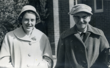
Photograph, Till Family
... ...evelyn...Black and white photograph of Alison Till and her mother Evelyn Till outside a house. Both are wearing hats and overcoats....Whitehorse Historical Society Inc. 2-10 Deep Creek Road Mitcham melbourne till evelyn alison bertha Black and white photograph of Alison Till and her mother Evelyn Till outside a house. ...Black and white photograph of Alison Till and her mother Evelyn Till outside a house. Both are wearing hats and overcoats.till, evelyn, alison bertha -
 Whitehorse Historical Society Inc.
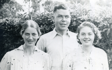
Photograph, Till family
... ...evelyn...Black and white photograph of family group: Evelyn, Alison and Alwyn Till standing in front of a weatherboard house....Whitehorse Historical Society Inc. 2-10 Deep Creek Road Mitcham melbourne till alison bertha evelyn alwyn Black and white photograph of family group: Evelyn, Alison and Alwyn Till standing in front of a weatherboard house. ...Black and white photograph of family group: Evelyn, Alison and Alwyn Till standing in front of a weatherboard house.till, alison bertha, evelyn, alwyn -
 Eltham District Historical Society Inc
Document - Certificate of Title, Landata, Vol. 4930 Fol. 985900, Crown Portion 15 Section 5, Parish of Nillumbik, County of Evelyn, 1925
... Vol. 4930 Fol. 985900, Crown Portion 15 Section 5, Parish of Nillumbik, County of Evelyn...(Cancelled) Certificate of Title originally issued for Crown Portion 15, Section 5 to Robert David Taylor, of Eltham, County of Evelyn, Farmer, 13 March 1925. It is with this title that the land allotment was subdivided into 48 lots. ...Eltham District Historical Society Inc 728 Main Rd Eltham melbourne (Cancelled) Certificate of Title originally issued for Crown Portion 15, Section 5 to Robert David Taylor, of Eltham, County of Evelyn, Farmer, 13 March 1925. It is with this title that the land allotment was subdivided into 48 lots. ...(Cancelled) Certificate of Title originally issued for Crown Portion 15, Section 5 to Robert David Taylor, of Eltham, County of Evelyn, Farmer, 13 March 1925. It is with this title that the land allotment was subdivided into 48 lots. The title shows the issuance to Robert David Taylor with encumbrance placed upon it by immediate former owner, Hugh Patrick Keogh, a former member for Gippsland and Melbourne Real Estate Agent. Following Taylor's death in 1934 the title passes to his Executors, sons Robert David Taylor of Bible Street, Eltham and William McLelland Vance Taylor of Northcote. The property is then sold to Frank Stokes who develops the Stokes Orchard. Compulsory acquisitions by the Melbourne Metropolitan Board of Works and State Electricity Commission show provisions of easemenst for town water supply and high voltage power transmission lines. Subsequent lots are then sold off with the development of the Stokes Orchard Estate residential development in the mid to late 1970s. A History of the Development of Crown Allotment 15, Section 5, Parish of Nillumbik – Stokes Orchard Crown Allotment 15, Section 5, Parish of Nillumbik (CA15) is a square allotment of 158 acres or approximately a quarter of a square mile. It lies just beyond the eastern end of Pitt Street, south of Nyora Road to the northern end of Eucalyptus Road and extends east from Eucalyptus Road to Reynolds Road. The topography of CA15 is generally steep, sloping up to a hill near the centre of the land, the ridgeline passing through the properties along the southern side of Diosma Road. Eucalyptus Road is a straight north-south road with its northern end at the north west corner of CA15. Until the end of the 1970s this road was an un-named Government Road and was largely not open to traffic. With residential development in the 1970s the road was constructed, and the council allocated the name obviously in recognition of the predominant species of the local bushland. CA15 was purchased from the Crown by George D’Arley Boursiquot, a prominent Melbourne printer, on 28th October 1852. On November 23, 1922, former Member for Gippsland and Melbourne Real Estate Agent, Hubert Patrick Keogh purchased the allotment then sold it March 13, 1925, to local farmer, Robert David Taylor, a former Shire of Eltham Councillor (1911-1920) and Shire President (1919). Taylor had extensive land holdings stretching west towards Bible Street and Main Road. The Taylor home was situated at the top of the hill in Bible Street at present day 82 Bible Street. At the time of Taylor’s purchase in 1925, CA15 was subdivided into 48 lots that could be described as small rural properties or large residential lots. A typical lot size was one hectare or 2.5 acres. The subdivision created two roads, Nyora Road, and Diosma Road, each following an irregular alignment between Eucalyptus and Reynolds Roads. However, the lots were not sold off separately nor were the roads constructed. The land effectively remained as one parcel for many further years. Robert David Taylor died November 30, 1934, and probate was granted to his son of the same name, Robert David Taylor of Bible Street, Salesman and William McLelland Vance Taylor of 73 Emmeline Street, Northcote, Clerk, with the transfer of the land into their names on July 8, 1935. Frank Stokes worked as a qualified accountant at Kennons leather factory in Burnley, while living at 1 Thomas Street, Mitcham. He suffered from migraines and wanted to return to working the land (he had previously worked on farms and orchards since coming to Australia from England in 1926, both in WA and Vic.). He first travelled to the district by train in July 1942 to find land with the intention to establish an orchard. By chance he met Arthur Bird of Bird Orchard (bounded by Pitt Street, Eucalyptus Road, and Wattle Grove) and they got talking over their common interest. Arthur put Frank up for the night and pointed out the land, 158 acres- part of the Taylor Estate- £900, Crown Allotment 15, Section 5, Parish of Nillumbik (CA15) somewhat diagonally opposite Bird Orchard. Stokes applied through the Riverina Agency to purchase the land who in turn applied for permission from Canberra to sell as there was a new government regulation introduced during the Second World War banning land sales except for immediate production. Stokes obtained a loan on his Mitcham house of £600 @ 5% and paid £450 deposit with quarterly payments of £15 spread over 5 years. Stokes was assisted and advised by Arthur Bird who farmed the neighbouring orchard. In early 1943 Stokes took possession and would catch the train out to Eltham on Fridays after work and began building a hut on the corner of Nyora Road and the Government Road (Eucalyptus Road) for shelter and to lock up tools. He established an orchard on the central western part of the land through the centre of which ran a natural waterway (part of the present-day linear park) and was able to pay a neighbour (Hawkins) to help with clearing and fencing 25 acres, and with a horse and single furrowed plough, planted approximately 2,500 fruit trees - cherries, peaches, plums, almonds, pears, apricots and lemons as well as a few apples and oranges; a massive task. Aerial photographs from the 1940s through to the 1990s clearly show the orchard with most of the larger CA15 site remaining as natural bushland. A huge problem was hares and rabbits eating all the new buds off the tiny trees. As well as laying poison he painted the trees with a mixture of cow manure and lime, often working by moonlight. Procurement of wire and wire netting was difficult because of the war but after much effort he obtained a permit from the Agricultural Department for supplies in March 1944. In February 1945 Stokes applied for a permit to build a “packing shed” as no house building was allowed. It was to be 33 feet x 21 feet and cost £312. It was constructed mostly from second-hand materials, which were hard to obtain, especially iron for roofing. Stokes finished work at Kennons on October 31, 1945, and in March 1946 he sold the family home at Mitcham for £1,230 plus £170 for furniture. On May 15, 1946, title to the CA15 property was issued to Frank Howard Alfred Stokes, Orchardist and Gladys Ethel Stokes, Married Woman, both of Pitt Street, Eltham. The family of five then moved into the very unfinished “packing shed” at Eltham, which was a struggle to weatherproof. Eventually rooms were divided off and lined with hessian bags and whitewashed. Their income was firewood (cut and sold), selling rockery stones and cut Sweet Bursaria. (It was discovered during the 1940s that Sweet Bursaria contained the sunscreen compound Aesculin. The RAAF utilised this compound from Sweet Bursaria during WW2 for pilots and gunners.) The orchard’s first fruit sale was a half-case of Le Vanq peaches in December 1947 for the price of 8 shillings. In 1956 plans for house were drawn and Glen Iris bricks purchased (1956 Olympic Rings variant). The building of the house commenced in 1957 - 12 feet of original packing shed was removed – and was completed in 1959. Water was connected from newly built pressure storage on the property at the end of 1959 and the electricity connection for the first time at 3pm on April 29, 1960. The house remains to present day (somewhat modified) at 1 Nyora Road, home to Nyora Studio Gallery. On occasions, spare remnants of the 1956 bricks have been known to be unearthed in gardens on the estate as they were utilised by Frank Stokes to fill in rabbit holes. On May 26, 1950, a parcel of land was compulsorily acquired by the Melbourne and Metropolitan Board of Works on the hilltop to establish an easement for a high-level service reservoir to augment Eltham’s water supply. The project also included pipe tracks for the necessary water mains. The reservoir has now been superseded by higher level water tanks east of Reynolds Road and its former site is now a public reserve. On November 27, 1964, the State Electricity Commission served notice to compulsorily acquire a further parcel through the eastern part of the land for a major electricity transmission line that augmented supply from the La Trobe Valley to Melbourne. The easement was registered February 11, 1966. The easement was widened July 18, 1969 for a second transmission line to be constructed. In 1971 Melbourne Metropolitan Planning Scheme amendments adopted Nyora Road as the boundary between a residential zone to the north and a rural zone to the south. This determined the future development of the land. In the mid-1970s the Shire of Eltham divided the orchard into numerous rate-able parcel lots, the 48 lots having been established in 1925 and the subsequent rates assessment proved unsustainable for Stokes. He commenced selling lots outside the boundary of the orchard, north of Diosma and South of Nyora. However shortly later the land between Nyora and Diosma Roads and west of the electricity easement was sold and subdivided into residential lots, a housing development by Macquarie Builders and marketed as the Stokes Orchard Estate. New streets were created, and most were named after trees, although one, Stokes Place, commemorates the former owners. The development was undertaken in two stages; Stage 1 (1975) encompassing Scarlet Ash Court, Ironbark Close and Peppermint Grove bounded by Nyora and Eucalyptus roads and Stage 2 (1978) encompassing Stokes Place, Orchard Way, The Crest and The Lookout bound by Nyora and Diosma roads. The developer, Macquarie Builders went bankrupt shortly after the release of Stage 2 leaving many purchasers to fend for themselves and arrange for their own independent builders. There were also difficulties with sewerage for the land immediately south of Diosma Road and so the conventional residential lots were abandoned in favour of larger lots. The development of Orchard Way, The Crest and The Lookout did not proceed as planned and the proposed lots were incorporated into five-acre parcels instead. These included a low-density group housing development by the Graves family and the award winning Choong House (1983) with Gordon Ford developed garden immediately next door situated on the ridge of the hill nestled amongst the original bush, Eucalypt trees and Sweet Bursaria. In 1994, Nillumbik Shire Council applied Significant Environment and Significant Landscape overlays upon the properties on the south side of Diosma Road to ensure protection of this natural bush garden environment. With the arrival of the sewer along Diosma Road in the 1990s, most of these five-acre parcels have since been subdivided multiple times. The Choong house presently sits on a 2.7-acre property, which in 2022 Nillumbik Council nominated for Cultural Significance Heritage protection and is considered potentially significant at State level. The Stokes family were also associated with the Eltham Christian Church. In the 1970s this church had met in temporary premises in Eltham. Lots of the original 1925 subdivision remained south of Nyora Road and a number of these lots were utilized for the Eltham Christian School, which was established by the Eltham Christian Church in 1981. The school operated on this site until 2000. The premises are now used by The Vine Baptist Church. By the mid-1980s the whole of CA15 had been developed for residential and school purposes, except for the sections north of Diosma Road and between the transmission lines and Reynolds Road. Sewerage issues had been resolved for the section north of Diosma Road and in 1987 it was in the process of being subdivided into residential lots. The development coincided with the discovery of colonies of the rare and endangered Eltham Copper Butterfly on the site. This resulted in a community and political campaign to save the butterfly habitat. With the co-operation of the land developer the subdivision was altered to create two bushland reserves in the critical butterfly habitat areas. In the late 1980s the State Government was investigating options for establishing a metropolitan ring road link between Diamond Creek and Ringwood. The chosen route was adjacent to Reynolds Road and so this created a freeze on development of CA15 between Reynolds Road and the electricity easement. The ring road proposal was eventually abandoned, and this part of the land was subdivided into low density residential lots. Diosma Road has been discontinued at the electricity easement and the eastern part incorporated into View Mount Court with access from Reynolds Road. The whole of CA15 has now been developed for residential or associated purposes, ranging from conventional density to quite low density south of Nyora Road. Some remnants of the orchard remain, a few cherry trees on the Graves property and a lone apple tree in Stokes Place. The butterfly reserves comprise significant areas of remnant bushland. Linear reserves through the estate link with central Eltham via the Woodridge linear reserve and with Research along the electricity easement. CA15 as it exists today has a complicated history of rural use, Government acquisition, urban development, and community action. References: • “Stokes Orchard, an incomplete history”; Russell Yeoman with Doug Orford • Correspondence, Beryl Bradbury (nee Stokes) • Aerial Photographs, 1931-1991, Landata (landata.vic.gov.au) • Certificate of Title, Vol. 4930 Fol. 985900 • Plan Number LP 10859 neil webster collection, diosma road, eltham copper butterfly, eucalyptus road, ironbark close, nyora road, peppermint grove, power transmission lines, reynolds road, scarlet ash court, stokes orchard estate, stokes place, woodridge estate, frank stokes, certificate of title -
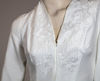 Lakes Entrance Historical Society
Clothing - Evelyn Hancocks wedding dress
... Wedding dress designed by Melbourne designer based on the wedding dress worn by Princess Margaret for the marriage of Miss Evelyn Hancock of Lakes Entrance...Two photographs of the wedding dress worn by Evelyn Hancock, design based on dress worn by Princess Margaret. ...Clothing Evelyn Hancocks wedding dress ...Wedding dress designed by Melbourne designer based on the wedding dress worn by Princess Margaret for the marriage of Miss Evelyn Hancock of Lakes EntranceTwo photographs of the wedding dress worn by Evelyn Hancock, design based on dress worn by Princess Margaret. Third photograph is of the bride Evelyn Hancock with her father Charles Hancock before leaving for her marriage.clothing -
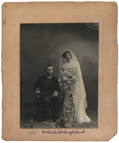 Federation University Historical Collection
Photograph - Photograph - Black and White, Yeoman Co, Reverend Charles Ed and Evelyn Smith and Smith Family, 1909
... Reverend Charles Ed and Evelyn Smith and Smith Family...Reverend Charles Ed and Evelyn Smith and Smith Family Photograph Photograph - Black and White Teslan Yeoman Co M.J. ....1 Black and white wedding photograph on a cream colored background .2 Ethel Smith, as a child, sepia photograph on black background .3. Elizabeth Garvey, nee Smith, sepia photograph on cream background .4 Harold Smith and Rupurt Smith sepia photograph on brown background .5 Alice and Florrie Hendri, sepia postcard .6 Memorial fold out card. Cream card with black borders..1 .2 Ethel Smith, father a minister .3. Elizabeth Garvey, nee Smith .4 Harold and Rupert Smith Corowa, 1894, Alice Watson, 7 Cromie Street Murtoa .5 Hendri girls, Alice and Florrie, writing on back, note to Edie from Alice Watson, 1911 .6 Memorial fold out card, in loving memory of Emma Watson, of Happy Valley,1888reverend charles ed, evelyn smith, ethel smith, corowa, mark allen studio, m.j. allen studio, harold smith, rupert smith, society studios, tesla studio, stella studio, alice watson, florrie hendri, emma keys smith, emma smith, george henry smith -
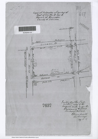 Eltham District Historical Society Inc
Document - Photocopy, Survey Field Notes of Part of Crown Portion 13, Section 4 at Eltham, Parish of Nillumbik, County of Evelyn, 29 May 1919
... Survey Field Notes of Part of Crown Portion 13, Section 4 at Eltham, Parish of Nillumbik, County of Evelyn...Woodcock, Licensed Surveyor, 29 May 1919 1919 Application 7637 Arthur Street Bible Street Luck Street Main Road Eltham Map Neil Webster Collection Survey Plan Surveyor Field Notes A3 printouts, 2 pages Survey Field Notes of Part of Crown Portion 13, Section 4 at Eltham, Parish of Nillumbik, County of Evelyn Document Photocopy ...Portion of land bounded by: Main Road, Luck Street, Bible Street, Arthur Street Application 7637 R.H. Woodcock, Licensed Surveyor, 29 May 19191919, application 7637, arthur street, bible street, luck street, main road eltham, map, neil webster collection, survey plan, surveyor field notes -
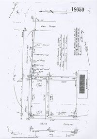 Eltham District Historical Society Inc
Document - Photocopy, Survey Field Notes of Part of Crown Portion 13, Section 4 at Eltham, Parish of Nillumbik, County of Evelyn, 18 October 1946
... Survey Field Notes of Part of Crown Portion 13, Section 4 at Eltham, Parish of Nillumbik, County of Evelyn...Connolly, Licensed Surveyor, 18 October 1946 Map Neil Webster Collection Survey Plan Surveyor Field Notes 1946 Application 18650 Bible Street henry street Main Road Eltham Maria Street Rose Street A3 printout, 1 page Survey Field Notes of Part of Crown Portion 13, Section 4 at Eltham, Parish of Nillumbik, County of Evelyn Document Photocopy ...Portion of land bounded by: Main Road, Henry Street, Bible Street Application 18650 W. Connolly, Licensed Surveyor, 18 October 1946map, neil webster collection, survey plan, surveyor field notes, 1946, application 18650, bible street, henry street, main road eltham, maria street, rose street -
![Document - Photocopy, Survey Field Notes of Part of Crown Portion 13, Section 4 at Eltham, Parish of Nillumbik, County of Evelyn [Bourke sic], 30 September 1949](/media/collectors/4f729f7b97f83e03086018a5/items/6869da03f3688aa02254c5c2/item-media/6869da22f3688aa02254c6da/item-fit-380x285.jpg?cb=6) Eltham District Historical Society Inc
Eltham District Historical Society IncDocument - Photocopy, Survey Field Notes of Part of Crown Portion 13, Section 4 at Eltham, Parish of Nillumbik, County of Evelyn [Bourke sic], 30 September 1949
... Survey Field Notes of Part of Crown Portion 13, Section 4 at Eltham, Parish of Nillumbik, County of Evelyn [Bourke sic]...Eltham District Historical Society Inc 728 Main Rd Eltham melbourne Portion of land bounded by: Main Road, Arthur Street, Dudley Street Application 21718 Erwin Dillon, Licensed Surveyor, 30 September 1949 Map Neil Webster Collection Survey Plan Surveyor Field Notes 1949 Application 21718 Arthur Street Dudley Street Main Road Eltham A3 printout, 1 page Survey Field Notes of Part of Crown Portion 13, Section 4 at Eltham, Parish of Nillumbik, County of Evelyn [Bourke sic] Document Photocopy ...Portion of land bounded by: Main Road, Arthur Street, Dudley Street Application 21718 Erwin Dillon, Licensed Surveyor, 30 September 1949map, neil webster collection, survey plan, surveyor field notes, 1949, application 21718, arthur street, dudley street, main road eltham -
 Eltham District Historical Society Inc
Document - Photocopy, Survey Field Notes of Part of Crown Portion 13, Section 4 at Eltham, Part of Lot 19 Subdivision of 13 Section IV (Holloways), Parish of Nillumbik, County of Evelyn, 5 May 1906
... Survey Field Notes of Part of Crown Portion 13, Section 4 at Eltham, Part of Lot 19 Subdivision of 13 Section IV (Holloways), Parish of Nillumbik, County of Evelyn...Mackensie Tyers, Licensed Surveyor, 5 May 1906 Map Neil Webster Collection Survey Plan Surveyor Field Notes 1906 Application 33777 Application 35953 henry street Main Road Eltham Maria Street Rechabite Hall* A3 printouts, 2 pages Survey Field Notes of Part of Crown Portion 13, Section 4 at Eltham, Part of Lot 19 Subdivision of 13 Section IV (Holloways), Parish of Nillumbik, County of Evelyn Document Photocopy ...Portion of land bounded by: Main Road, Henry Street Application 35953 A. Mackensie Tyers, Licensed Surveyor, 5 May 1906map, neil webster collection, survey plan, surveyor field notes, 1906, application 33777, application 35953, henry street, main road eltham, maria street, rechabite hall* -
 Eltham District Historical Society Inc
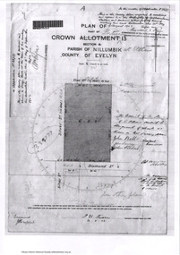
Document - Photocopy, Survey Field Notes of Part of Crown Portion 12, Section 4 at Eltham, Parish of Nillumbik, County of Evelyn, 12 August 1910
... Survey Field Notes of Part of Crown Portion 12, Section 4 at Eltham, Parish of Nillumbik, County of Evelyn...Arndt, Licensed Surveyor, 12 August 1910 Map Neil Webster Collection Survey Plan Surveyor Field Notes 1910 Application 38858 Bible Street John Street Main Road Eltham Pitt Street A3 printout, 1 page Survey Field Notes of Part of Crown Portion 12, Section 4 at Eltham, Parish of Nillumbik, County of Evelyn Document Photocopy ...Portion of land bounded by: Main Road, John Street, Bible Street, Pitt Street Application 38858 K. Arndt, Licensed Surveyor, 12 August 1910map, neil webster collection, survey plan, surveyor field notes, 1910, application 38858, bible street, john street, main road eltham, pitt street -
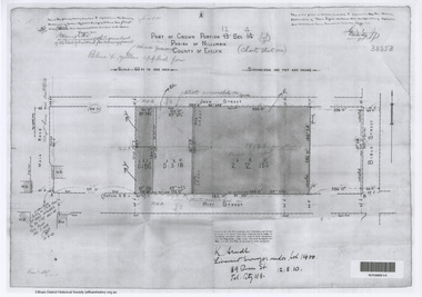
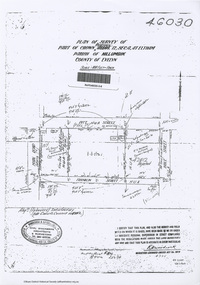 Eltham District Historical Society Inc
Document - Photocopy, Survey Field Notes of Part of Crown Portion 12, Section 4 at Eltham, Parish of Nillumbik, County of Evelyn, 4 July 1924
... Survey Field Notes of Part of Crown Portion 12, Section 4 at Eltham, Parish of Nillumbik, County of Evelyn...Grant Main Road Eltham Maria Street Peel Street Pitt Street A3 printout, 1 page Survey Field Notes of Part of Crown Portion 12, Section 4 at Eltham, Parish of Nillumbik, County of Evelyn Document Photocopy ...Portion of land bounded by: Main Road, Pitt Street, Bible Street, Franklin Street Application 46030 R.H. Woodcock, Licensed Surveyor, 4 July 1924map, neil webster collection, survey plan, surveyor field notes, 1924, application 46030, bible street, corn store, ernie andrew, franklin street, l. grant, main road eltham, maria street, peel street, pitt street -
 Eltham District Historical Society Inc
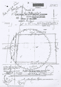
Document - Photocopy, Survey Fleld Notes of Part of Crown Portion 13, Section 4 at Eltham, Parish of Nillumbik, County of Evelyn, 1902-1903
... Survey Fleld Notes of Part of Crown Portion 13, Section 4 at Eltham, Parish of Nillumbik, County of Evelyn...Eltham District Historical Society Inc 728 Main Rd Eltham melbourne Main Road, Henry Street to Diamond Street; Silver Street to Bible Street Application No. 033777 1902 1903 Arthur Street Bible Street Bird street Diamond Creek (Creek) Diamond Street Eltham Eltham Railway Station henry street Main Road silver street Survey Plan Vine street Application 33777 Map A4 printouts, 7 pages Survey Fleld Notes of Part of Crown Portion 13, Section 4 at Eltham, Parish of Nillumbik, County of Evelyn Document Photocopy ...Main Road, Henry Street to Diamond Street; Silver Street to Bible Street Application No. 0337771902, 1903, arthur street, bible street, bird street, diamond creek (creek), diamond street, eltham, eltham railway station, henry street, main road, silver street, survey plan, vine street, application 33777, map