Showing 488 items
matching first survey
-
 Bendigo Military Museum
Photograph - Retired Officers of the Royal Australian Survey Corp on Corps Day, School of Military Survey, Latchford Barracks, Bonegilla, 1991
This is a photograph of three retired officers from the Royal Australian Survey Corps taken on Corps Day, at the School of Military Survey, Latchford Barracks, Bonegilla in July 1991. BRIG Don Macdonald AM served in the Australian Regular Army from 1st of January 1936 to 22nd of March 1967. He was the Director of the Survey Corps from January 1960 to March 1967. COL Macdonald was promoted to Brigadier before assuming the honorary position of Colonel Commandant of RA Svy from August 1967 to January 1973. LTCOL Bob Skitch served in the Australian Regular Army from 14th of February 1955 to 27th of February 1981. He was the CO of the Army Survey Regiment from 1976 to 1980. LT Leo Noel Fletcher MID served in the Australian Regular Army from 1st January 1938 to 14th November 1945. He was the NSW Surveyor General from 1965 to 1978.This is a photograph of three retired officers from the Royal Australian Survey Corps taken on Corps Day, at the School of Military Survey, Latchford Barracks, Bonegilla in July 1991. The black and white photograph was printed on photographic paper and is part of the Army Survey Regiment’s Collection. The photograph was scanned at 300 dpi. .1) - Photo, black & white, 1991, retired RA Svy officers – L to R: LT Leo Noel Fletcher MID, LTCOL Bob Skitch, BRIG Don Macdonald AM.Annotated on front of photo ‘RASvy Corps Day1991. Three of the Corps past members meet for the first time in many years. Lt Noel Fletcher (ex NSW Surveyor General), Lt Col Bob Skitch and Brig Don MacDonald.’royal australian survey corps, rasvy, army survey regiment, army svy regt, fortuna, asr, school of military survey -
 Kiewa Valley Historical Society
Book - Geographical Survey, Geographical Survey Report 31st Dec. 1977 prepared by Thos. Couchman Secretary for Mines
... . These pages show heavy use. geological survey 1878 dargo bogong First ...Office of Mines published progressive reports on the Geological Survey of parts of Victoria.This book includes a chapter on 'Dargo and Bogong' Pages 96 - 117 and includes a fold out map of this area. These pages show heavy use.Hard deep red cover with gold printed title located at the centre top. Bound with spine blank. 217 pages. Date 1878 First chapter and some pages have pencil marks including page 97.geological survey 1878, dargo, bogong -
 Warrnambool and District Historical Society Inc.
Document - Documents (3) of Farnham Cheese and Butter factory, 1890s (originals)
... (Warrnambool). The name 'Farnham' is the name of the Special Survey... (Warrnambool). The name 'Farnham' is the name of the Special Survey ...These three sheets are copies of the originals and relate to the establishment of the Farnham Cheese and Butter Factory in Dennington (Warrnambool). The name 'Farnham' is the name of the Special Survey in the area first purchased by William Rutledge and also the name of the Rutledge property at Dennington. In 1889 WIlliam Rutledge (Junior) and Thomas Palmer established the Farnham Cheese and Butter Factory on the banks of the Merri River at Dennington. In 1890 they sold the factory to a farmers' co-operative. Farnham had a high reputationfor butter=making when the factory was in existence. The factory was bought out by Nestles about 1909 with that company establishing its factory on the same area.in 1911. These documents are of interest as the Farnham Cheese and Butter Factory was one of the earliest of its type in the Western District and won a Gold Medal in 1909 for butter-making at the Islington Dairy Show in competition with other butter-making countries in the world..1 sheet of paper with black and white map showing location of factory in Dennington (copy) .2 An A3 size piece of paper with a sketch map and typed material showing a Certificate of Title (copy) .3 An 3 size piece of paper with a sketch map and typed material showing a Certificate of Title (copy)farnham cheese and butter factory, nestles factory warrnambool -
 Warrnambool and District Historical Society Inc.
Chain link measure, Gunter, Early 20th century
This Gunter’s Chain, an old land surveying instrument, is named after its inventor, Edmund Gunter (1581-1626), an English mathematician and astronomer. It was first produced in 1620. The tool has 100 links and is 66 feet or one chain long. The links are marked off in groups of ten by metal rings or tags. A quarter chain (25 links) is called a rod or pole and ten chains make a furlong and 80 chains make a mile. The traditional cricket pitch is 22 yards or one chain long. This Gunter’s Chain is of considerable significance because: 1. It is an early land measuring tool that was used for over 250 years and has great historical and mathematical significance. A Gunter’s Chain would have been used when forming and building local roads from the earliest days of settlement. 2. It has a possible local connection as it was given to the Historical Society by a local person in 1965 and possibly came from the property of ‘Rosehill’ This is a metal tool which consists of 100 metal pieces or links joined together by loops at each end with two metal loops in between each link. The links joined together form a chain. The two ends of the chain have small metal handles attached At intervals along the chain there are additional rings or metal pieces attached. Some white and green rope material has been used to bundle up the chain. The metal is somewhat rusted. gunter’s chain, land measurement tools, history of warrnambool -
 Warrnambool and District Historical Society Inc.
Chain link measure, Gunter's Chain, 19th Century
A Gunter’s Chain, an old land surveying instrument, is named after its inventor, Edmund Gunter (1581-1626), an English mathematician and astronomer. It was first produced in 1620. The tool has 100 links and is 66 feet or one chain long. The links are marked off in groups of ten by metal tags or rings. A quarter chain (25 links) is called a rod or pole and ten chains make a furlong and 80 chains a mile. The traditional cricket pitch is 22 yards or one chain long. This chain is said to have been used by Gilbert Nicol when the Warrnambool to Hamilton Road was constructed in the 19th century. Gilbert Nicol was an early settler in Warrnambool who, with John Craig, established the first hotel (and the first building) in Warrnambool in 1847. Nicol later owned the property ‘Rosehill’ in the Warrnambool area. As the chain was given to the Warrnambool and District Historical Society by the Town Clerk, Keith Arnel, it is likely that the chain was one of the items in the old Warrnambool MuseumThis Gunter’s Chain is of importance because it is an early land measuring device that was used for over 250 years and has great historical and mathematical significance. If it is correct that it was used by Gilbert Nicol when the Warrnambool to Hamilton Road was built then it has considerable local significance and dates back to the 19th century. This is a metal tool which consists of 100 metal pieces or links joined together by loops at each end with two metal loops in between each link. The links joined together form a chain. The two ends of the chain have small metal handles attached. At intervals along the chain there are additional rings or metal pieces attached. The metal is very rusted.gunter’s chain, land measurement tools, history of warrnambool -
 Warrnambool and District Historical Society Inc.
Map, Department of Lands and Survey (Lithographers), Caramut township, 1938
This map of the township of Caramut was produced in 1938 but shows the original land owners of each town allotment and of the surrounding area. The size of all the allotments and the date of the original purchase are also shown. Caramut is a Victorian Western District town on Mustons Creek on the Hamilton Highway 48 kilometres from Warrnambool. This map was used by Rolf Crawley when he was the engineer for the Shire of Warrnambool from 1935 to 1968. The annotations on the map have probably been made by Rolf Crawley as they refer to the records and letter books of his father, John William Crawley, Junior (Shire of Warrnambool Engineer 1895 to 1935). Both Rolf Crawley and his father, John had private businesses as architects, surveyors and engineers and the map could have been used in connection with both their official Shire duties and their private businesses. The last owner of the map was the surveyor, Michael Hand who took over the business of Rolf Crawley in the late 1960s. This map is of great interest firstly because it has all the historical details of the land first purchased in the town of Caramut and area and secondly because it came from the office of Rolf Crawley, the engineer for the Shire of Warrnambool from 1935 to 1968. This is a buff-coloured paper map with a cloth backing. The map details are in black and white print. There are some handwritten red and black annotations on the map. “Town of Caramut Parish of Caramut County of Villiers’town of caramut, john william crawley junior, warrnambool, rolf crawley, warrnambool -
 Warrnambool and District Historical Society Inc.
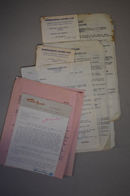
Document, Letters & Minutes, 1960s
These documents contain information about the Warrnambool Racing Club in the 1960s. Race meetings were held in Warrnambool as early as 1848, a few months after the first white settlers arrived. The Warrnambool Racing Club was formed in 1854 and the present day racecourse was first used in 1858. In 1872 the well-known Warrnambool Grand Annual Steeplechase was first held. These documents came from the office of Rolf Crawley, a surveyor, architect and engineer in private practice in Warrnambool and also the engineer for the Shire of Warrnambool from 1935 to 1968. His grandfather, father and uncle were also engineers, working in that capacity or as the Shire Secretary for the Shire of Warrnambool, with the Crawley family recording a total of 132 years of service to the Shire. The Shire of Warrnambool existed from 1863 to 1994. These documents came into the possession of Michael Hand who took over the private surveying practice in Warrnambool of Rolf Crawley. The Warrnambool and District Historical Society acquired these documents, along with several ledgers and other Crawley memorabilia, from the estate of Michael Hand. These documents are of interest as they contain much information on the Warrnambool Racing Club and will be of assistance to researchers.This is a collection of documents relating to the Warrnambool Racing Club. They are typewritten letters and Minutes summaries. Some are copies and there are two cards giving notice of meetings. rolf crawley, warrnambool, warrnambool racing club, shire of warrnambool -
 Warrnambool and District Historical Society Inc.
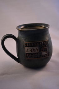
Household, Souvenir Cup (Warrnambool’s 150th ), 1997
This cup was produced by Ken Sadler as a souvenir of the 150th anniversary of the settlement of Warrnambool. Ken Sadler was a potter in Liebig Street, Warrnambool for many years (end of 20th century and beginning of 21st century). Warrnambool was founded as a planned town in 1847 to provide port facilities for the produce of squatters who had settled in the area. The town centre was surveyed by William Pickering at the request of Superintendent La Trobe of Melbourne and the first land sales were held in Melbourne in July 1847. The celebrations to mark the 150th anniversary of Warrnambool included concerts, race meetings, church services and the erection of an anniversary tablet on Cannon Hill. Ken Sadler, a well-known Warrnambool potter, made 500 of these cups which are now collectible souvenirs of the city’s 150th anniversary celebrations. This one retained by the Warrnambool and District Historical Society is numbered 189. The 150th anniversary of the founding of Warrnambool was an important event in the city’s history.This is a ceramic cup with a round base and larger rounded body with a round overhanging rim at the top opening. The cup is mottled green with an impressed image of a ship and lettering in white, gold and brown. There is some lettering on the bottom of the cup.‘Warrnambool 150th Anniversary 1847-1997’ ‘Sadler 97 189/500 Warrnambool’ warrnambool’s 150th anniversary, history of warrnambool, ken sadler, warrnambool potter -
 Warrnambool and District Historical Society Inc.
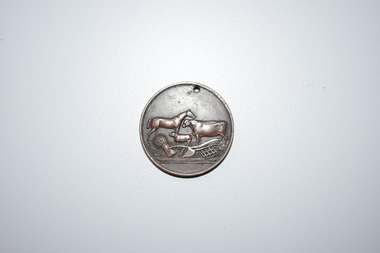
Medal, Stokes and Martin, Rutledge Brothers, 1877
This medal was made by Stokes and Martin. Thomas Stokes established a medal-making business in Melbourne in 1856 and from 1867 to 1893 he had a partner, George Frederick Martin. In 1962 the Stokes business became a public company and operates today in Melbourne. The medal was awarded at the Annual Show of the Villiers and Heytesbury Agricultural Association in 1877. One of the earliest agricultural associations in Victoria, the V.& H.A.A., the forerunner of the Warrnambool Agricultural Society, was established in 1854 and the first Warrnambool Show was held in 1855 at the first Royal Archer Hotel in Koroit Street. The Warrnambool Agricultural Show is still held annually. The medal, first prize for the best horse hay rake, was awarded in 1877 to the brothers, Thomas and William Rutledge, sons of Eliza and William Rutledge. The latter was a pioneer settler who came to the Warrnambool/Port Fairy district as the purchaser of the Special Survey, Farnham Park in 1841. His land stretched from Tower Hill to Dennington. William Rutledge Senior was a pioneer breeder of a Lincoln sheep stud, the owner of a mercantile business in Port Fairy, a member of the Legislative Council of Victoria and the pioneer developer of farming land around Tower Hill. His son Thomas (1846-1918) was a Warrnambool Shire Councillor who farmed in the Farnham Survey, living at Werronggurt . He went to the Geelong area at the end of the 19th century. His brother William (1849-1935) also farmed in the Farnham Survey, living at Farnham Park, He later lived at Airlie in Henna Street, Warrnambool and Sherwood on the Hopkins River and had land in the Otway Ranges. He later went to New Zealand.This medal is of considerable significance because of its age and its association with Thomas and William Rutledge and with the Villiers and Heytesbury Agricultural Association.This is a bronze medal with an image of agricultural implements, agricultural produce and farm animals on one side and etched printing on the other side. There is also printing around the edge of the medal. The medal has a small hole at the top for attaching the medal to a cord. Villiers & Heytesbury Agricultural Association 1st Prize awarded to Rutledge Bro. for Horse Hay Rake Annual Show Warrnambool 10 Oct. 1877 Stokes & Martin Melbourne thomas and william rutledge, farnham special survey, villiers and heytesbury agricultural association, warrnambool agricultural society, history of warrnambool -
 Warrnambool and District Historical Society Inc.
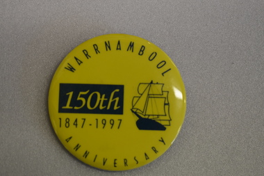
Badge, Warrnambool 150th 1847-1997
This badge was produced in 1997 as a souvenir of the 150th anniversary of the founding of Warrnambool. Warrnambool was a planned town, established in 1847 as a port to service the squatters who had taken up large tracts of land in the Warrnambool area in the 1840s.The town was surveyed by the Government surveyor William Pickering at the request of Superintendent La Trobe and the first town lots of the new town were sold in Melbourne in 1847, with some settlers arriving at the new settlement soon after.This badge is one of the many souvenirs of the 1997 celebrations in Warrnambool Circular concave metal badge with blue drawing of a sailing ship and text. There is a clip pin on the reverse.WARRNAMBOOL ANNIVERSARY 150th 1847 -1997 -
 Eltham District Historical Society Inc
Document - Folder, Survey Maps and Technical Drawings
alan gardiner collection, maps -
Glen Eira Historical Society
Plan - Pascoe Avenue, 26, Bentleigh
Document detailing two valuations by National Trustees Co of the property at 26 Pascoe Ave, Bentleigh, the first valuation is dated 14/07/1954 and the second dated 19/07/1957. Included are handdrawn plans, handwritten notes and typed valuations listing values of architectural features, and correspondence from National Trustees Co. for both 1954 and 1957. The 1954 documents were clearly used in the 1957 valuation.pascoe ave, land subdivisions, land values, bentleigh, pergolas, architectural features, parish of moorabbin, plans, architectural styles, county of bourke, maps, brick houses, national trustees co, illustrations, dendy’s crown special survey -
 Eltham District Historical Society Inc
Document - Binder, Eltham Justice Precinct, 1969-2020
EDHS_04863 - Binder: Eltham Justice Precinct 1. Courthouse 1. Eltham Courthouse interesting facts 2. Plan and elevation drawings 3. Other courthouse plans and fittings 1880s – Brunswick, Maffra, Dunolly , Sunbury, Landsborough and Wodonga 4. Newspaper articles: i. ELTHAM POLICE COURT. (1892, April 1). Evelyn Observer, and South and East Bourke Record (Vic. : 1882 - 1902), p. 2 (MORNING.). Retrieved July 5, 2022, from http://nla.gov.au/nla.news-article60667022 ii. BREAKING A PUBLICAN'S LEG. (1900, July 13). Evelyn Observer, and South and East Bourke Record (Vic. : 1882 - 1902), p. 2 (MORNING.). Retrieved July 5, 2022, from http://nla.gov.au/nla.news-article60688367 iii. ELTHAM COURT. (1901, March 1). Mercury and Weekly Courier (Vic. : 1878 - 1903), p. 3. Retrieved July 5, 2022, from http://nla.gov.au/nla.news-article58578953 iv. ANNIE CHASES A TINKER. (1902, October 3). Evelyn Observer, and South and East Bourke Record (Vic. : 1882 - 1902), p. 2 (MORNING.). Retrieved July 5, 2022, from http://nla.gov.au/nla.news-article64029968 v. ELTHAM POLICE COURT. (1927, May 6). Advertiser (Hurstbridge, Vic. : 1922 - 1939), p. 4 (AFTERNOON). Retrieved July 5, 2022, from http://nla.gov.au/nla.news-article57754748 vi. ELTHAM POLICE COURT. (1927, May 20). Advertiser (Hurstbridge, Vic. : 1922 - 1939), p. 3 (AFTERNOON). Retrieved July 5, 2022, from http://nla.gov.au/nla.news-article57754814 vii. Eltham Police Court (1931, January 9). Advertiser (Hurstbridge, Vic. : 1922 - 1939), p. 4. Retrieved July 5, 2022, from http://nla.gov.au/nla.news-article56734073 viii. Repairs to Eltham Police Station, The Advertiser (1929, May 24). Advertiser (Hurstbridge, Vic. : 1922 - 1939), p. 2 (AFTERNOON.). Retrieved July 5, 2022, from http://nla.gov.au/nla.news-article57759907 ix. ELTHAM COURT. (1929, August 2). Advertiser (Hurstbridge, Vic. : 1922 - 1939), p. 4 (AFTERNOON.). Retrieved July 5, 2022, from http://nla.gov.au/nla.news-article57760345 x. See also Trove list https://trove.nla.gov.au/list/116634 5. Letter: Shire of Eltham Historical Society to Shire of Eltham, 1 July 1969 regarding potential replacement of Eltham Courthouse and the building’s historical significance and acknowledgement 10 July 1969 6. Letter: Shire of Eltham Historical Society to Law Department, 26 May 1972, re preservation of Eltham Courthouse and potential classification and acknowledgement 7 June 1972 7. Newspaper article: Strangers around, so Eltham sought protection by Marguerite Marshall, Diamond Valley News, Tuesday, April 6, 1982, p2 (On reverse side, Top job for our Pauline, p1) 8. Eltham Courthouse Colour Scheme, Public Works Department, 10 September 1983 9. Newspaper article: Eltham Courthouse under threat of closure by Helen Gillman, Diamond Valley News, October 16, 1984 10. Newspaper article: Courthouse to close by Helen Gillman, Diamond Valley News, Tuesday, November 20, 1984, p1 (also on p2 an article about Diamond Valley Shire festivities for the State’s 150th) 11. We will keep your court – Kennett, Diamond Valley News (probable), c.Dec. 1984 12. Letter: Shire of Eltham to Shire of Eltham Historical Society, 15 March 1985, regarding potential for use of building as a museum and reply dated 17 April 1985 regarding Society’s interest in use of the building 13. Letter: Department of Conservation Forests & Lands to Shire of Eltham, August 1987, regarding expressions of interest in the building and letter from Shire (18 August 1987) to Society advising of same 14. Letter: Department of Conservation Forests & Lands to Shire of Eltham, 30 March 1988, advising Courthouse to be used by Eltham Youth Resources Centre and the rear section by other community groups. Noted that the historical society was suggested by Council as a future user of the adjoining police residence when Council first sought management of the building and that should be investigated. Includes Schedule of Repair and Maintenance Work (4 pages), Existing Conditions Survey 30/7/1987 (6 pages) and 1 page plan view diagram 15. Memo: Historic Places Section to Eltham Youth Resource Centre re paint analysis of Courthouse, 17/5/1988, (6 pages) 16. Newspaper article: Courthouse renovation by Jodie Haythorne, Diamond Valley News, November 23, 1992 17. National Trust of Australia Registration (classified 20 Oct 1977), printed March 2000 18. Letter: Heritage Victoria 28 Feb 2002 regarding the replacement of the Courthouse Stand (Witness Box) 19. Article: There’s still order in this stately court house, Eltham Shire (magazine), date unk., p22-23 20. Eltham Court House, Statement of Significance, Heritage Victoria Register, printed Nov 2004 21. Eltham 1860 Former Court House 730 Main Road Eltham, collated by Eltham District Historical Society Incorporated 2005 (4 pages) 22. Book Extract: Eltham, Historical Court Houses of Victoria by Michael Challinger, Palisade Press, 2001 23. Newspaper article: Courthouse rich with history by Harry Gilham, Nillumbik Mail, c.2001 (see also EDHS_03333) 24. Notes on history of site from Crown Reserve File Rs 12128, Municipal Buildings (Local Community Welfare Reserve) at Eltham, Department of Sustainability and Environment, April 2005 (4 pages) 25. Newspaper article: Historic building upgrade, Diamond Valley Leader, August 3, 2005, p17 26. Newspaper article: Courthouse regeneration secures boost, Valley Weekly, August 10, 2005 with picture of Harry Gilham, Steve Herbert and Greg Johnson 27. Newspaper article: Poets are summonsed, Diamond Valley Leader February 22, 2006, p37 features picture of Helen Lucas at the Eltham Courthouse 28. Newspaper article: Sharing a love of legalities, Diamond Valley Leader, March 1, 2006, p7 features a picture of Rob Hulls and Steve Herbert talking to students in the courthouse 29. Newspaper advertisement: Nillumbik Tender No. 2021-33, Building Restoration Works, Old Eltham Courthouse, The Age, November 7, 2020 30. Form: Police Officer’s Return To A Warrant Of Distress 31. Handwritten notes: three pages listing all 48 of the pigeon hole form listings in the cabinet in the courthouse 2. Police Quarters 1. 1971 Surveyors Plan of 728 Main Road and the Adjoining Courthouse 2. Letter: Shire of Eltham to Shire of Eltham Historical Society, 5 June 1981, requesting the society give consideration to the suitability of the existing buildings (former Vermin and Noxious Weeds Office, Department of Crown Lands and Survey) for historical purposes such as a museum 3. Minutes: Shire of Eltham Historical Society Committee Meeting, 10 June 1981 (2 pages) includes reference to possible use of building as a museum (also reference to Bills Horse trough to be retained) 4. Extract from Victoria Police Gazette 1930 with details of building and site 5. Newspaper article: Cubby haven, Diamond Valley News, October 28, 1991 about replica Police Station with picture of replica along with Monika Roitinger and Garry Bartlett outside the Police Station 6. Environment office up for sale? Mountain Views, Monday, June 12, 1995 (Nillumbik Shire Council proposing to sell property. Did not proceed as ownership held by the State of Victoria) 7. Extract from National Trust February 1998 edition, “Police Rescue” which states Heidelberg and Eltham Police Residences are the oldest known Police Residences in the Melbourne Metropolitan district 8. Newspaper article: The first police office by Harry Gilham, Nillumbik Mail, December 13, 2000 (also photocopy with notations on picture identifying buildings and Harry’s typed draft) 9. Fax Memo: Victoria Police List of Officers in Charge, Eltham Police Station, 1857-1991 onward, 21 Jan 2003 10. Former Police Quarters, Statement of Significance, Heritage Victoria Register, printed Nov 2004 11. Eltham 1860 Former Police Quarters 728 Main Road Eltham, collated by Eltham District Historical Society Incorporated 2005 (5 pages) 12. Report: Eltham District Historical Society to Living and Learning Nillumbik, 14 April 2010 regarding the poor state of condition of the former Police Residence 13. Photocopy of three photos of the former Police Residence, former Police Station (relocated to rear of site) and Stables, October 18, 1991 3. Lockup 1. Newspaper article: Heritage permit bid, Diamond Valley News, January 17, 2001 (also article “Eltham library tops”) includes picture of lockup located in Youth Road 2. Newspaper article: Old lockup in new site, Diamond Valley Leader, March 21, 2001, p15. Includes picture of Harry Gilham with lockup at justice Precinct 3. Letter: Victoria Police to Eltham District Historical Society, 20 March 1991 including laser print photo of lockup in 1963 at 23 Pryor Street 4. Fax: Graham Clark, Associated Crane Trucks Pty Ltd, 833 Main Road Hurstbridge; Quote 26.2.99 for $1,080 to move lockup from Youth Road to 728 Main Road 4. Local History Centre 1. Victoria Government Gazette: Photocopy, No. 165, Tuesday, December 7, 1858, establishment of a Court of Petty Sessions at Eltham, 7 December 1858 2. Victoria Government Gazette: Photocopy, September 16, 1859, contract issued for Police buildings at Eltham to Langridge and Co., McCarter, Baillie, Nicol and Co, Chadley, Amos and Co., Cameron, Payne, £1,150.7.0 3. Victoria Government Gazette: Photocopy, October 2, 1860, contract issued for Court of Petty Sessions at Eltham to James Duncan, £600 4. President’s Report, Eltham District Historical Society, Annual General Meeting, Wednesday, March 11, 1998 – covers the establishment of the Local History Centre and new home for the Society 5. Extract for EDHS Newsletter July 1998 – Eltham Local History Centre – Official Opening 6. Unveiling of 728 Street Sign, Speech notes by Cr Dianne Bullen, December 2000, includes invoice from John Sharp Signs Pty Ltd, 24/10/2000 and planning approval drawing dated 24/3/1999 reproduced in Newsletter No. 135 November 2000 7. Letter: Eltham District Historical Society to Living and Learning Centre, undated draft regarding being a member of the committee reviewing the development of the site 8. Notes from Rod Grant re funding of site development under the Community Jobs Program 9. Letter: Eltham District Historical Society to Nillumbik Living and Learning, 28 October 2004 re inclusion of the Society in enhancing the site under the Community Jobs Program 10. Letter: Department of Sustainability and Environment to Eltham District Historical Society, 28 February 2005 re preparing draft Conservation Plan and copy of cover letter in response 2 April 2005 11. Levels and Layout Plan, Nillumbik Shire Council, September 2005, AO copy 12. Letter: Department of Sustainability and Environment to Eltham District Historical Society, 12 September 2005 re Eltham Justice Precinct Conservation Management Plan 13. Letter: Living and Learning Nillumbik, 2 February 2006 to Eltham District Historical Society re forming a Committee to advise on the use, maintenance, management and preservation of the Justice Precinct 14. Minutes: Meeting of a Task group to explore the establishment of a Committee to manage the Eltham Justice Precinct, 20 December 2005 (with hand written notes) 15. President’s notes (EDHS), General Meeting item, 11 May 2006 pertaining to use and condition of the Eltham Justice Precinct 16. Paint estimates, Old Eltham Court House, undated 17. Notes from meeting 26 September (2006), Eltham Justice Precinct Committee 18. Notes from meeting 27 November (2006), Eltham Justice Precinct Committee 19. Terms of Reference for the Eltham Justice Precinct Committee, Draft for Living and Learning Committee Meeting 24 Jan 2007 (4 pages) 20. Newspaper article: Panel set up, Diamond Valley Leader, 7 March 2007 21. Minutes: Meeting of Eltham Justice Precinct Subcommittee, 10 May 2007 22. Minutes: Meeting of Eltham Justice Precinct Subcommittee, 5 July 2007 23. Minutes: Meeting of Eltham Justice Precinct Subcommittee, 11 October 2007 24. Minutes: Meeting of Eltham Justice Precinct Subcommittee, 7 February 2008 25. Minutes: Meeting of Eltham Justice Precinct Subcommittee, 10 April 2008 26. Minutes: Meeting of Eltham Justice Precinct Subcommittee, 14 August 2008 27. Letter: EDHS (Sue Law) to Living and Learning, 6 September 2008 re proposed signage 28. Agenda: Meeting of Eltham Justice Precinct Subcommittee, 16 October 2008 29. Suggested guidelines for use of the Court House for exhibitions 30. Handwritten note re Ken Eckersal and Uniting Church of possible donation of church organ for sale, proceeds to be used for activities at the Justice precinct 31. One page typed notes on each of the buildings in the Eltham Justice Precinct 5. Miscellaneous 1. Photocopy from Pioneers & Painters (2 pages) covering the establishment of Police and Court of Petty Sessions at Eltham 2. Photocopy of photo looking northeast across Little Eltham buildings c.1910 with notes 3. Photocopy of J.H Clarke photo looking up Maria Street from near Dalton Street with notes identifying precinct buildings 4. Photocopy of photo of Court House and Police Quarters with cow outside from Heather Jenkins scrapbook with notes identifying buildings 5. Sketch and notes with dimensions for blue stone lockup including other miscellaneous handwritten notes 6. Unidentified heritage review details of Justice Precinct (c.2004) 7. Hand written notes of telephone conversation held with Dennis McKay (6 May 1997) re Council use of site 8. Flyer: Victoria Police Historical Unit 9. Photocopy of thumbnail images of various Justice Precincts (not identified) 10. Email correspondence, 4 and 10 January 2008; J. Connor to Council and Councillors pertaining to proposed new toilet facilities at rear of Courthouse annexe. Two ring lever arch binder, white with various photocopies, printouts, newspaper clippingsHG Folders 15/52/59 integratedharry gilham collection, eltham courthouse, eltham justice precinct, eltham police residence, lockup, eltham community festival, eltham festival, eltham, heritage assessment, police residence -
Federation University Historical Collection
Book - Book - Scrapbook, Ballarat Institute of Advanced Education: Scrapbook of newspaper cutting, Book 8; January 1974 to April 1974
Newspaper cuttings relating to Ballarat Institute of Advanced Education. These are from various newspapers and include The Age, Ballarat Courier, The Australian, The Herald. The cuttings cover the period from 1 January 1974 to 27 April 1974. Book with yellow cover, front. Spiral bound.ballarat institute of advanced education, biae, employment advertisements, application for enrolment, outline of courses, science students, boom year for biae, buses between ballarat and mount helen campus, amalgamation of ballarat and clarendon colleges, "youth 2004" forum, david vinegrad, john lewis, vital role for metallurgists, brian sunter, e phillips, post-grad awards, noel janetski, john reitze, room crisis for students, tertiary education at the crossroads, jack barker, biae chemists, 100 nurses to study at biae, enrolment boom at biae, union black ban on biae project, rationalisation - what's it all about, artists' exhibition, university report deplored by byrne, government plans country campuses, gold medals family tradition, guy falla, kiran mazumdra, first woman - malting and brewing course, top plumbing apprentice guy falla, survey slams ballarat eyesores, michael langford, david sandeman, ingrid blake-education officer at gallery, visual pollution, biae library available to all, malaysian students in australia, merger of state college and biae expected -
Federation University Historical Collection
Book - Book - Scrapbook, Ballarat College of Advanced Education: Scrapbook of newspaper cutting, Book 4; October 1978 to March 1979
Newspaper cuttings relating to Ballarat College of Advanced Education. These are from various newspapers and include The Age, Ballarat Courier, The Australian, The Herald. The cuttings cover the period from 11 October 1978 to 16 March 1979. Inauguration of Australia's first postgraduate diploma course in occupational hazard management hailed as a milestone for safety in Australia. Book with yellow cover, front. Spiral bound.employment advertisements, application for enrolment, outline of courses, new gallery big success, norman baggaley, nick violi electronic engineering, keith fuller research program, solar heat, variety in engineering studies, accidents take tragic toll, derek viner, occupational safety group, marquetry exhibition, henry moritz, study of human factors in industry, max brookes, ballarat college of advanced education, bcae - a community resource, community studies-surveys by bcae, overseas librarians visit ballarat, bachelor of arts course approved, frank hurley, awards to bcae students, rodney jude, phillip brewis, engineers elect new chairma, zig plavina, tippett portrait for bcae, four wins for kathie wise, female sculler, bcae won't wait for new buildings, post graduate safety course next year, speech aid gift, vincent bugno final year project, derek woolley, electrical engineering, teacher gets a lesson, terry osborne art student, rodney nicholls awarded scholarship, walter lonie, president - australasian institute of mining and metallurgy, ian anderson wins gift, norman baggaley - head of art, hsc students apprehensive, dr len cubitt, windmills victim of high costs, council's plan to combat flooding, making music at summer school, students' gallery, difficult year ahead, vtu calls for new teacher policies, bcae course hailed as milestone, occupational hazard management, laurence mason, eric wigglesworth, royal australian college of surgeons, derek viner bcae lecturer, role of governments in industrial safety, brain drain crisis for teaching, campus city, ballarat cae leads way, graham werner, cedric snowdon, scholarship winners, mining and metallurgy, visit by senator webster, papua new guinea students, mining engineering career, scientific approach to fitness -
Federation University Historical Collection
Book - Book - Scrapbook, Ballarat College of Advanced Education: Scrapbook of newspaper cutting, Book 5; March 1979 to August 1979
Newspaper cuttings relating to Ballarat College of Advanced Education. These are from various newspapers and include The Age, Ballarat Courier, The Australian, The Herald. The cuttings cover the period from 21 March 1979 to 4 August 1979. . Book with grey cover, front. Spiral bound.employment advertisements, application for enrolment, outline of courses, scholarships for bcae students, western mining corporation, gunther jahnks, stephen fernee, jim stringer, robert withers former student, earthquakes, new men at bcae, geoff westcott, garry kinnane, jeffrey leeuwenberg, study of muscle power, dr alan roberts, mark heuston, new at bcae, cao duc thac - school of business, bruce cossins - civil engineering, val lloyd - librarianship department, prof hilda elkins - librarianship department for 6 months, community support vital to colleges, inquiry committee in ballarat, growing concern for sports injuries, shortage of qualified metallurgists, 400 graduate, graeme jeffries engineering, accountancy prize to belinda tantau, john wach appointed to mt stromlo observatory, energy seminar, minister for minerals and energy, teacher union may put ban on bcae, bcae director replies, bcae indoor sports facilities popular, chemical institute branch formed, great hall takes shape, educationalists in ballarat, another degree for frank hurley, dr mosley on barrier reef, posters depict conservation, bcae gets gift of logo, bcae's first annual council meeting, pilot fatigue significant factor, management training - business survey, better decision makers, industrial safety, engineering heritage display, why people take risks, vtu boycott suspended, prof david klein u.s.a., prof praises bcae course, swimming instructors 2-day course, david jelbart retires, gunther jahnke wins arblaster award, bcae library expands, regional colleges -
Federation University Historical Collection
Book - Book - Scrapbook, Ballarat College of Advanced Education: Scrapbook of newspaper cutting, Book 8; September 1980 to March 1981
Newspaper cuttings relating to Ballarat College of Advanced Education. These are from various newspapers and include The Age, Ballarat Courier, The Australian, The Herald. The cuttings cover the period from 5 September 1980 to 12 March 1981. The opening of Founder's Hall was covered in March item. . Book with yellow cover, front. Image of two trotters. Spiral bound.employment advertisements, application for enrolment, outline of courses, sir mark oliphant, educationkey to future, dr jim cairns, victoria chapter of ace, seminar on country tv, bcae survey to help portland, nukool limsettoe former smb student, bcae recreation study, non competitive running success, shadow of the mount marathon, bcae's computer harbor, facilities in schools inadequate, shortage of teachers predicted, bcae gets firemobile, teachers' college students reunion, innovative projects, music synthesiser, on whispering trail, concern at art teachers' future, bcae 10 years old, first aid awards for p e students, radio for fire brigade, sports medicine symposium, fine art degree course, missing girl, faye atkinson, coastal engineering, lack of funds, cutbacks in engineering courses, deakin stands firm on course status, vacation jobs for metallurgy students, up with world harbor trends, dr graham allen, hatchet man, future good for engineers, engineering courses cut, new look for education, survey into gold mining prospects, bcae steering a safe course, hostel charges hike, beaufort house, bcae allowed to award degree qualifications, windpower, integrating handicapped children, greenhill summit run, founder's hall opening, sir zelman cowen, scholarship winners, mark foord engineering, david condle metallurgy, research grantsawarded, swimming team -
Federation University Historical Collection
Book - Book - Scrapbook, Ballarat College of Advanced Education: Scrapbook of newspaper cutting, Book 10; September 1981 to May 1982
Newspaper cuttings relating to Ballarat College of Advanced Education. These are from various newspapers and include The Age, Ballarat Courier, The Australian, The Herald. The cuttings cover the period from 2 September 1981 to 6 May 1982. . Book with grey cover, front. Image of image of two trotters. Spiral bound.employment advertisements, application for enrolment, outline of courses, more students less money, bcae staff cuts, fewer graduates in engineering, half marathon, need for more maths and science students, energy resources control warning, bcae spring festival, companies woo bcae engineering graduates, engineering students and 'the iron horse', recreation survey, p e degree course, energy saving project, student winemakers, tom nestor wins award, nigerian students studies ground movement, sir arthur nicholson, golden taste of success, ivan durrant on art students, critical time for ballarat's economy, first group to complete arts degree, francis brown, john mcmahon, award in metallurgy, award in mechanical engineering, pottery group's first show, rich clays of ballarat, colleges to retrench staff, retirement of frank ryan, growing computer industry, new job in northern territory, break-in brumbies, ballarat's young jobless, librarians enter computer age, tertiary chief sacked, dr jim watson, hsc seminar at bcae, students eat too much fast food, chemistry graduate to work in canberra, stephen wilson, dianne budge to work in alice springs, physical fitness director of ymca, revamp for key tertiary commission, lake weed problem, businessmen wooed, move to promote health fitness, scholarships for students, robert allan artist, move to save bendigo course, hobby course for gold prospectors, john crump ceramics, day of firsts at bcae, track and field titles win, tamara beckier artist, abstract art, talks on future of regional colleges, government funding -
 Bendigo Military Museum
Photograph - Army Survey Regiment - Regimental Training Navigation Exercise, 1985
This is a set of 16 photographs of Army Survey Regiment personnel undertaking a non-tactical navigation exercise, part of the field phase of regimental training in the Wellsford Forest, Bendigo 1985. This was one of the six regimental training objectives outlined in the administrative instruction – Exercise “City Soldier” accompanying these photos. The other objectives were SLR rifle and M30 grenade handling revision, and first aid at Fortuna; RATEL at Wellsford Forest and rifle shooting at Wellsford Rifle Range. Personnel from Air Survey, Cartographic, Lithographic and Headquarters Squadrons were reallocated to four training platoons for one week from 7th to 11th October 1985.This is a set of 16 photographs of Army Survey Regiment personnel undertaking a navigation exercise in the Wellford Forest, Bendigo 1985. Black & white photos .1P to .10P are printed on photographic paper and scanned at 300 dpi. Photos .11P to .16P are on 35mm negative film and scanned at 96 dpi. They are part of the Army Survey Regiment’s Collection. .1) - Photo, black & white, 1985, L to R: CPL Mick Minchin, SGT Alan Staley, CPL Megan (McBurney) Reynolds SPR Wendy (Leitinger) McCarthy. .2) - Photo, black & white, 1985, L to R: unidentified, SPR Wendy (Leitinger) McCarthy, CPL Megan (McBurney) Reynolds, unidentified, SGT Alan Staley, SPR Dave Lawler. .3) - Photo, black & white, 1985, L to R: CPL Greg Honan, CPL Grant McGuinness, SPR Leah (Hoffman) Peppler, CPL Ken Peters, SSGT Ian ‘Rock’ Thistleton, SSGT Kevin ‘Spook’ Kennedy. .4) - Photo, black & white, 1985, unidentified personnel. .5) - Photo, black & white, 1985, L to R: CPL Peter ‘Spoon’ Lefel, unidentified, CPL Mick ‘Buddha’ Ellis. .6) - Photo, black & white, 1985, L to R: SSGT Harald Mai, unidentified. .7) - Photo, black & white, 1985, unidentified personnel. .8) - Photo, black & white, 1985, unidentified personnel. .9) - Photo, black & white, 1985, WO1 Dick Manley. .10) - Photo, black & white, 1985, L to R: LT Brenton MacDonald, LT Kathie Ryan, WO1 Brian Mead. .11) - Photo, black & white, 1985, L to R: LT Carol Dunstan, unidentified, CPL John Reid. .12) - Photo, black & white, 1985, L to R: WO1 Dick Manley, unidentified, LT Carol Dunstan. .13) - Photo, black & white, 1985, L to R: unidentified (x2), WO1 Dick Manley. .14) - Photo, black & white, 1985, LT Brenton McDonald. .15) - Photo, black & white, 1985, L to R: CPL Megan (McBurney) Reynolds, SPR Wendy (Leitinger) McCarthy, CPL Mick Minchin. .16) - Photo, black & white, 1985, L to R: SPR Wendy (Leitinger) McCarthy, CPL Mick Minchin..1P to .16P – No personnel are identified.royal australian survey corps, rasvy, army survey regiment, army svy regt, fortuna, asr -
 Bendigo Military Museum
Photograph - Army Survey Regiment - Regimental Training at Wellsford Rifle Range, Bendigo, 1985
This is a set of seven photographs of Army Survey Regiment personnel undertaking live fire SLR rifle qualification training at Wellsford Rifle Range, Bendigo 1985. This was the last of six regimental training objectives outlined in the administrative instruction – Exercise “City Soldier” accompanying these photos. The other objectives were SLR rifle and M30 grenade handling revision, and first aid at Fortuna; and navigation and RATEL at Wellsford Forest. Personnel from Air Survey, Cartographic, Lithographic and Headquarters Squadrons were reallocated to four training platoons for one week from 7th to 11th October 1985. Rifle shooting at Wellsford Rifle Range occurred for two days at the end of the week.This is a set of seven photographs of the Army Survey Regiment undertaking live fire rifle qualification training at Wellsford Rifle Range, Bendigo, 1985. Black & white photos .1P to .5P are printed on photographic paper and scanned at 300 dpi. Photos .6P to .7P are on 35mm negative film and scanned at 96 dpi. They are part of the Army Survey Regiment’s Collection. .1) - Photo, black & white, 1985, unidentified personnel. .2) - Photo, black & white, 1985, unidentified personnel. .3) - Photo, black & white, 1985, unidentified personnel. .4) - Photo, black & white, 1985, MAJ Terry Edward. .5) - Photo, black & white, 1985, unidentified US Army Exchange officer. .6) & .7) - Photo, black & white, 1985, unidentified rifle range safety officer..1P to .7P – No personnel are identifiedroyal australian survey corps, rasvy, army survey regiment, army svy regt, fortuna, asr -
 Bendigo Military Museum
Photograph - Army Survey Regiment - Regimental Training Military Skills Revision, 1985
This is a set of 35 photographs of the Army Survey Regiment personnel undertaking military skills revision, at the Army Survey Regiment, Fortuna, Bendigo, 1985. They participated in lessons on the handling of the M30 Grenade and SLR Rifle. These lessons were part of the six objectives of regimental training outlined in the administrative instruction – Exercise “City Soldier” accompanying these photos. The other objectives were first aid at Fortuna, RATEL and navigation at Wellsford Forest; and rifle shooting at Wellsford Rifle Range. Personnel from Air Survey, Cartographic, Lithographic and Headquarters Squadrons were reallocated to four training platoons for one week from 7th to 11th October 1985.This is a set of 35 photographs of the Army Survey Regiment undertaking military skills revision, part of Regimental Training at Fortuna Villa 1985. Black & white photos .1P to .17P are printed on photographic paper and scanned at 300 dpi. Photos .18P to .35P are on 35mm negative film and scanned at 96 dpi. They are part of the Army Survey Regiment’s Collection. .1) - Photo, black & white, 1985, L to R: CPL Brian Fauth, unidentified (x2), SGT Dennis Learmonth - instructor, unidentified (x2). .2) - Photo, black & white, 1985, unidentified personnel, SGT Dennis Learmonth – instructor. .3) - Photo, black & white, 1985, unidentified personnel, SGT Dennis Learmonth – instructor. .4) - Photo, black & white, 1985, unidentified personnel, SGT Dennis Learmonth - instructor. .5) - Photo, black & white, 1985, unidentified personnel. .6) - Photo, black & white, 1985, unidentified personnel. .7) - Photo, black & white, 1985, L to R: SGT Dennis Learmonth – instructor, CPL Brian Fauth, SPR Viv (Hawkins) Doherty, CPL Ken Peters, CPL Megan (McBurney) Reynolds, CPL Mick ‘Buddha’ Ellis, unidentified, SPR Wally Twidale, unidentified personnel. .8) - Photo, black & white, 1985, L to R: unidentified personnel, LT Ossie Slade. .9) - Photo, black & white, 1985, L to R: unidentified personnel, CPL Greg Honan, SGT Don Williams, LCPL Bob Sheppard, unidentified personnel. .10) - Photo, black & white, 1985, L to R: unidentified personnel, SPR Bloxham, SPR Jason Wells, unidentified personnel, CPL Gillham, CPL Peter Imeson, unidentified. .11) - Photo, black & white, 1985, L to R: SPR Terry Winzar, unidentified, WO1 Noel ‘Nesty’ Coulthard, unidentified personnel. .12) - Photo, black & white, 1985, unidentified personnel. .13) - Photo, black & white, 1985, L to R: SSGT Tony Harder – UK Exchange Instructor, unidentified personnel, CPL Bob Thrower, unidentified, SPR Jim Humphrey, LCPL Bob Sheppard. .14) - Photo, black & white, 1985, L to R: unidentified personnel, CPL Mark Casey, SSGT Tony Harder – UK Exchange Instructor. .15) - Photo, black & white, 1985, L to R: unidentified, CPL Paul Richards, SPR John Keely, CPL Peter Johnson, unidentified, SSGT Tony Harder – UK Exchange Instructor, SPR Dave Wright, unidentified personnel. .16) - Photo, black & white, 1985, L to R: unidentified, WO2 Brian Partridge – Instructor, unidentified personnel. .17) - Photo, black & white, 1985, WO2 Brian Partridge – Instructor, unidentified personnel. Unidentified. .18) - Photo, black & white, 1985, CPL Lea-anne (Smallshaw) Shirley, CPL Megan (McBurney) Reynolds, SGT Dennis Learmonth – instructor. .19) - Photo, black & white, 1985, SSGT Steve Hansen – Instructor, from background tree L to R: SPR Dave Lawler, CPL Ken Peters, CPL Steve Burke, SPR Wally Twidale, CPL Dave Murphy, SPR Jim Walker. .20) - Photo, black & white, 1985, L to R: unidentified (x3), CPL Ian Nelson, CPL Eddy Jacobs, SPR Tracy (Parker) Ash, remainder unidentified. .21) - Photo, black & white, 1985, CPL Eddy Jacobs piggybacking SPR Jason Wells, remainder unidentified. .22) - Photo, black & white, 1985, CAPT Dave McLachlan piggybacking unidentified soldier. .23) - Photo, black & white, 1985, unidentified soldiers competing in leapfrog race. .24) - Photo, black & white, 1985, SPR Leah (Hoffman) Peppler throwing dummy hand grenade, SSGT Ian ‘Rock’ Thistleton – Instructor. .25) - Photo, black & white, 1985, unidentified soldiers’ basic pouches cleared by instructor at end of hand grenade lesson. .26) - Photo, black & white, 1985, unidentified soldier throwing dummy hand grenade. .27) - Photo, black & white, 1985, unidentified personnel with dummy hand grenades, SGT Dennis Learmonth – instructor. .28) - Photo, black & white, 1985, unidentified soldier throwing dummy hand grenade. .29) - Photo, black & white, 1985, unidentified personnel with dummy hand grenades, unidentified instructor. .30) - Photo, black & white, 1985, adjusting SLR rifle gas plugs L to R: unidentified, SPR John Keely, CPL Paul Richards, unidentified, CPL Peter Johnson, remaining personnel unidentified, unidentified instructor. .31) - Photo, black & white, 1985, L to R: unidentified (x6), SPR Dave Wright, unidentified, SPR Barry Hogan, CPL Lyall Camp, SSGT Tony Harder – UK Exchange Instructor, SPR Steve Coulson, CPL Mark Lander. .32) - Photo, black & white, 1985, SLR rifle lesson L to R: unidentified, CPL Gary Drummond, SSGT Steve Hansen – Instructor in background, CPL Peter Breukel, SPR Steve Burke, CPL Brian Fauth, remaining personnel unidentified. .33) to .35) - Photo, black & white, 1985, unidentified personnel during SLR rifle lesson..1P to .35P No personnel are identifiedroyal australian survey corps, rasvy, army survey regiment, army svy regt, fortuna, asr -
 Bendigo Military Museum
Photograph - Army Survey Regiment - Regimental Training First Aid, 1985
... Army Survey Regiment - Regimental Training First Aid...Army Survey Regiment - Regimental Training First Aid...This is a set of 14 photographs of the Army Survey Regiment... photographs of the Army Survey Regiment undertaking first aid training ...This is a set of 14 photographs of Army Survey Regiment personnel undertaking the First Aid phase of regimental training held at Fortuna, Bendigo c1985. This was one of six objectives outlined in the administrative instruction – Exercise “City Soldier” accompanying these photos. The other objectives were weapons skills revision for SLR Rifle and M30 Grenade at Fortuna; RATEL and navigation at Wellsford Forest; and rifle shooting at Wellsford Rifle Range. Personnel from Air Survey, Cartographic, Lithographic and Headquarters Squadrons were reallocated to four training platoons for one week from 7th to 11th October 1985.This is a set of 14 photographs of the Army Survey Regiment undertaking first aid training, part of Regimental Training at Fortuna Villa, Bendigo. 1985. .1P to .8P are printed on photographic paper and scanned at 300 dpi. Photos .9P to .14P are on 35mm negative film and scanned at 96 dpi. They are part of the Army Survey Regiment’s Collection. .1) - Photo, black & white, 1985, L to R: WO1 Dick Manley – instructor, CPL Paul Davis. .2) - Photo, black & white, 1985, L to R: CPL Paul Davis, WO1 Dick Manley – instructor. .3) - Photo, black & white, 1985, L to R: WO2 Bill Kemp, – instructor, unidentified personnel. .4) - Photo, black & white, 1985, WO2 Bill Kemp, – instructor. .5) - Photo, black & white, 1985, L to R: CPL Dave Murphy, LT Carol Dunstan – instructor. .6) - Photo, black & white, 1985, L to R: SPR Wally Twidale, unidentified personnel. .7) - Photo, black & white, 1985, L to R: LT Carol Dunstan – instructor, SPR Viv (Hawkins) Doherty. .8) - Photo, black & white, 1985, unidentified WO2. .9) - Photo, black & white, 1985, L to R: WO1 Dick Manley – instructor, unidentified, LT Carol Dunstan – instructor. .10) - Photo, black & white, 1985, L to R: CPL Ken Peters, unidentified, SPR Viv (Hawkins) Doherty, unidentified (x3), LT Carol Dunstan – instructor in foreground, CPL Mick Minchin. .11) & .12) - Photo, black & white, 1985, WO2 Dave Miles with fake injured leg. .13) & .14) - Photo, black & white, 1985, unidentified officer– instructor, SPR Lorraine (Daly) Talbot-Smith..1P to .14P No personnel are identifiedroyal australian survey corps, rasvy, army survey regiment, army svy regt, fortuna, asr -
 Bendigo Military Museum
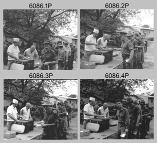
Photograph - Army Survey Regiment - Regimental Training BBQ, 1985
This is a set of 14 photographs of Army Survey Regiment personnel attending a BBQ lunch during regimental training, at the basketball/tennis court area of Fortuna Villa, Bendigo, 1985. There were six regimental training objectives outlined in the administrative instruction – Exercise “City Soldier” accompanying these photos. They were SLR rifle and M30 grenade revision, and first aid at Fortuna; RATEL and navigation at Wellsford Forest; and rifle shooting at Wellsford Rifle Range. Personnel from Air Survey, Cartographic, Lithographic and Headquarters Squadrons were reallocated to four training platoons for one week from 7th to 11th October 1985. Personnel were warned in for lunch on 10th and 11th of October 1985. This is a set of 14 photographs of Army Survey Regiment personnel attending a regimental training BBQ lunch at Fortuna Villa, Bendigo, 1985. .1P to .10P are printed on photographic paper and scanned at 300 dpi. Photos .11P to .14P are on 35mm negative film and scanned at 96 dpi. They are part of the Army Survey Regiment’s Collection. The photographs were printed on photographic paper and are part of the Army Survey Regiment’s Collection. .1) - Photo, black & white, 1985, L to R: unidentified personnel, PTE Evans, LCPL Brown - cooks, CAPT Laurie Newton, WO2 Brian Partridge, CAPT Danny Galbraith. MAJ Daryl Hockings CSM, unidentified personnel. .2) - Photo, black & white, 1985, L to R: unidentified personnel, PTE Evans, LCPL Brown - cooks, MAJ Mick Byrne, CAPT Bob Williams, unidentified, LT Doug Maxwell, WO2 Brian Partridge, CAPT Danny Galbraith. .3) - Photo, black & white, 1985, L to R: unidentified personnel, PTE Evans, LCPL Brown - cooks, CAPT Bob Williams, unidentified, LT Doug Maxwell, unidentified personnel. .4) - Photo, black & white, 1985, L to R: unidentified personnel, PTE Evans, LCPL Brown - cooks, LT Doug Maxwell, unidentified, CAPT John South, unidentified personnel. .5) - Photo, black & white, 1985, L to R: unidentified personnel, MAJ Terry Edwards - background, SGT Morris – cook. .6) - Photo, black & white, 1985, L to R: unidentified, CPL Gary Tremain, unidentified, MAJ Terry Edwards, 2LT Kathie Ryan – background. .7) - Photo, black & white, 1985, L to R: SGT Charlie Creedy, SGT Wally Chilcott, LT Carol Dunstan, 2LT Kathie Ryan, LT Ossie Slade. .8) - Photo, black & white, 1985, L to R: CPL Terry ‘TJ’ Wicker, unidentified personnel, SPR Roy Hicks, SPR Dave Wright, unidentified personnel. .9) - Photo, black & white, 1985, L to R: unidentified personnel, SGT Jeff Willey, SGT Wally Chilcott, CPL Gary Tremain. .10) - Photo, black & white, 1985, L to R: foreground - CPL Megan (McBurney) Reynolds, LCPL Bob Sheppard, CPL Bob Thrower, background - CPL Peter Breukel, WO1 Doug Arman, CPL Brian Johnson. .11) - Photo, black & white, 1985, L to R: RSM WO1 Bob Mason, PTE Evans, LCPL Brown - cooks, CAPT Danny Galbraith. .12) - Photo, black & white, 1985, L to R foreground: unidentified (x2), CPL Roy Hicks, CPL Megan (McBurney) Reynolds, unidentified (x2), CPL Peter Breukel, unidentified (x2), LT Ozzy Slade. .13) - Photo, black & white, 1985, L to R: LCPL Brown – cook, WO2 Brian Partridge, unidentified, WO2 John Hook, WO1 Bill Griggs, unidentified, CAPT Danny Galbraith, unidentified. .14) - Photo, black & white, 1985, L to R foreground: MAJ Kim Weston, CAPT Bob Williams, CAPT Danny Galbraith, unidentified, unidentified US Army Exchange officer..1P to .14P No personnel are identifiedroyal australian survey corps, rasvy, army survey regiment, army svy regt, fortuna, asr -
 Bendigo Military Museum
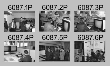
Photograph - Technical Tour of the Army Survey Regiment, Fortuna, Bendigo, c1984
This collection of 10 photos was most likely taken in 1984. It’s evident in these photos the visitors were taken on a tour through the production areas of Air Survey Squadron, with Wild B8 photogrammetic plotting workstations featured in the first three photos and demonstrations of the AUTOMAP 2 production system in the following photos. The AUTOMAP 2 system was an upgrade to the AUTOMAP 1 system comprising Intergraph graphic edit workstation terminals networked to VAX 750/785 main frame computers. Unlike AUTOMAP 1, operators could display digital topographic features on monitors for editing. Successful adaptation of this system meant RASvy was at the forefront of digital mapping/cartographic systems in Australia and overseas. The system comprised Input (B8 feature extraction) Raster Scanning (digitising from compilation sheets, Graphic Edit (cartographic completion) and Plot Verification Sub Systems. CAPT Rob John was the project officer responsible for the acceptance trials and implementation of AUTOMAP 2. The system was operational from 1984 to its ‘Newheart’ upgrade in 1993. Throughout its life, the system was progressively refined with productivity gains, achieved from award winning technical development in-house by talented and innovative Army Survey Regiment personnel.This is a set of 10 photograph of a technical tour of the Army Survey Regiment at Fortuna, Bendigo, c1985. The photographs were printed on 35mm photographic proofing paper and are part of the Army Survey Regiment’s Collection. The photographs were scanned at 600 dpi. .1) - Photo, black & white, c1984, unidentified visitors, CAPT Rob John, MAJ Jim Mitchell, unidentified. .2) - Photo, black & white, c1984, unidentified visitor. .3) - Photo, black & white, c1984, unidentified visitor. .4) - Photo, black & white, c1984, unidentified SGT .5) - Photo, black & white, c1984, L to R: LTCOL Jorge Gruszka, unidentified visitors. .6) - Photo, black & white, c1984, L to R: SGT George Timmins, unidentified visitors. .7) - Photo, black & white, c1984, MAJ John Charland – US Exchange Officer. .8) - Photo, black & white, c1984, L to R: unidentified visitors and personnel, MAJ John Charland – US Exchange Officer. .9) - Photo, black & white, c1984, unidentified visitors and personnel, MAJ John Charland – US Exchange Officer in background. .10) - Photo, black & white, c1984, L to R: MAJ Bob Roche, CAPT Mick Byrne in Officers Mess..1P to .10P No personnel are identifiedroyal australian survey corps, rasvy, army survey regiment, army svy regt, fortuna, asr, air survey, automap -
 Bendigo Military Museum
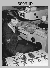
Photograph - Army Survey Regiment – Map Production, Fortuna, Bendigo, c1980s
These five photographs of map production and the car park area were taken at Fortuna, Bendigo, c1980s. The first three photographs were taken in Air Survey Squadron, where aerotriangulation and digital photogrammetric extraction of topographic features from aerial photography were undertaken. Photo .4P was taken in Cartographic Squadron’s Correcting Section, located in the Attic. The technicians were probably involved in a rapid response map production, as they all were wearing field uniforms. The Army Survey Regiment’s Duty Room, RAP and Carpark appear in Photo .5P. It was probably taken from the top steps near the SGT’s accommodation block in 1986. Photos .4P and .5P are also published with item 6395.17P.This is a set of five photograph of Map Production and car park, at the Army Survey Regiment, Fortuna, Bendigo, c1980s. The photographs were printed on photographic paper and is part of the Army Survey Regiment’s Collection. Photograph .1P was scanned at 200 dpi. The others were scanned at 300 dpi. .1) - Photo, black & white, c1980s: CPL Marrianne (Van De Zee) De Groot measuring aerial photographs with a stecometer. .2) - Photo, colour, c1980s: Two unidentified technicians assessing a flight line diagram. .3) - Photo, black & white, c1980s: SPR Scheryl Delforce digitising map features on an AUTOMAP 1 Graticon table. .4) - Photo, black & white, 1986: L to R: CPL Andy Lucas, SPR Chris Gordon, unidentified, SPR Jan (Crighton) Minchin, SPR Robin Marshall, CPL Frank Downie, SPR Gayle Humphrey, unidentified technicians in the Attic, Fortuna. .5) - Photo, black & white, 1986: Army Survey Regiment Duty Room, RAP and Carpark at Fortuna. .1P - Annotated on back ‘Maryanne Degroot’ .2P, .4P to .5P – no annotation .3P - Annotated on back ‘Scheryl Delforce’royal australian survey corps, rasvy, army survey regiment, army svy regt, fortuna, asr, air survey, carto, aerotrig -
 Bendigo Military Museum
photograph - Cartographic Squadron Production – Army Survey Regiment, Fortuna, c1980
This collection of 12 photos was most likely taken in 1980. The photos were most likely taken in Cartographic Squadron’s Ante Room, the Attic and small offices on the top floor of Fortuna Villa. The computer based Editwriter typesetting system was introduced in 1975 as a replacement to the aging Fotosetter machine. It was operated by a specialised technician, who generated a large variety of map type styles and sizes quickly and reliably, as well as text panels. CPL Richards performed this task for several years and in photo .1P and .2P is reading off a type order next to the computer monitor. Output on Copy proof adhesive backed stripping type film replaced messy wax and spray adhesives in 1978. The Editwriter capability supported all RASvy units and contractor type setting requirements. Scribing was the cartographic process of drafting features such as drainage, relief, vegetation, roads and culture on specially coated map reproduction material. The cartographic technician scribed out the map feature such as a contour to a specified line width on the map sheet, using a tool affixed with a sapphire tipped cutter. The quality control edit (Proving) stage of map production was the first opportunity to inspect a proof of the map independently and systematically. Proving tasks were carried out by technicians conversant of the map product specification and task requirement, however, was not involved in its production. Corrections were identified, marked up and sent to back to the correcting section or contractors. Terrain Embossing was a manual map production technique to produce hill shading on medium to small scale graphics and air charts. SPR John Martin is seen in photos .8P to.10P using a fine embossing metal stylus to push down on the drainage impression on a thin malleable opaque plastic material (AK Poligraphy). Ridge lines were then pushed down using the contour impression as a guide, on the opposing side of the AK Poligraphy to create a 3D plastic model terrain effect. The map impression was sprayed with white paint and photographed to create a contone tone hill shade. SPR Gina (Coore) Neilson is seen in photo .11P washing a contone positive of a land mass in a solution. The contone components were registered to the map sheet, as shown in photo .12P and masked using an air brush and a halftone negative was then created. The terrain embossing method of producing hill shading was more efficient to produce than previous specialised artistic methods such pencil/eraser and air brush. Furthermore, a more consistent enhancement of terrain on charts was achieved between technicians.This is a set of 12 photographs of Cartographic Squadron performing four map production tasks at the Army Survey Regiment, Fortuna, Bendigo c1980. The first ten photographs were on 35mm negative film and were scanned at 96 dpi. Photos .11P and .12P were on photographic paper and scanned at 300 dpi. They are part of the Army Survey Regiment’s Collection. .1) - Photo, black & white, c1980, Editwriter typesetter, CPL Paul Richards. .2) - Photo, black & white, c1980, Editwriter typesetter, CPL Paul Richards. .3) - Photo, black & white, c1980, Scribing contours on a RAAF Chart, SPR Megan (McBurney) Reynolds. .4) - Photo, black & white, c1980, Scribing contours on a RAAF Chart, SPR Megan (McBurney) Reynolds. .5) - Photo, black & white, c1980, Scribing contours on a RAAF Chart, SPR Rod Skidmore. .6) - Photo, black & white, c1980, Scribing contours on a RAAF Chart, SPR Rod Skidmore. .7) - Photo, black & white, c1980, Formal quality control edit (Proving), CPL Ian Belmont. .8) - Photo, black & white, c1980, Hill Shade Terrain Embossing, SPR John Martin. .9) - Photo, black & white, c1980, Hill Shade Terrain Embossing, SPR John Martin. .10) - Photo, black & white, c1980, Hill Shade Terrain Embossing, SPR John Martin. .11) - Photo, black & white, c1980, Hill Shade Terrain Embossing, SPR Gina (Coore) Neilson. .12) - Photo, black & white, c1980, Hill Shade Terrain Embossing, unidentified..1P to .10P No personnel are identified. .11P and .12P annotated ‘Terrain Embossing’royal australian survey corps, rasvy, army survey regiment, army svy regt, fortuna, asr, carto -
 Bendigo Military Museum
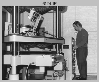
photograph - Orthorectification Equipment - Army Survey Regiment, Fortuna, Bendigo, c1975
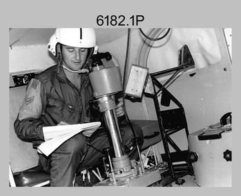
Orthophoto mapping provided the Survey Corps with the capability to produce map products quickly in the event of a crisis. These are four photographs of equipment used by the Army Survey Regiment to produce orthophotomaps. The Wild GZ1 orthophoto projector was introduced in 1973 and was the first equipment used to orthorectify colour and monochrome film aerial photography. Height profiles were originally produced on a PEB8 Stereo profiler and later were software generated. Photos of the PEB8 are available in Victorian Collections item 6222.17P, photos .5P and .6P. In the same era the IBM 1130 computer; OMI/Nistri AP/C-3 analytical plotter with coordinatograph, OP/C orthophoto projector and Zeiss Planimat D2 stereoplotters were introduced. Orthorectification is the process of removing geometric distortions and scale errors/variations from images. Images have tilt and relief distortions that make it difficult to compare accurately a map and an image of the same geographic area. Once an image is orthorectified, features on the image are shown in their planimetric locations. These four photographs of orthorectification equipment were taken at the Army Survey Regiment at Fortuna, Bendigo, c1975. Photo .1P and .3P were printed on photographic paper and scanned at 300 dpi. Photos .2P, .4P and .5P were on 35mm negative film and scanned at 96 dpi. They are part of the Army Survey Regiment’s Collection. .1) - Photo, black & white, c1975, Wild GZ1 orthophoto projector operated by CPL Phil Boyle. .2) - Photo, black & white, c1975, Wild GZ1 orthophoto projector. .3) - Photo, black & white, c1975, Wild GZ1 orthophoto projector. .4) - Photo, black & white, c1978, Zeiss D2 Planimat Stereoplotter. .5) - Photo, black & white, c1978, Zeiss D2 Planimat Stereoplotter..1P to .5P No annotations.royal australian survey corps, rasvy, army survey regiment, army svy regt, fortuna, asr -
 Bendigo Military Museum
Photograph - Royal Australian Survey Corps Aerial Surveys, c1980
... the Royal Australian Survey Corps operating aerial surveys equipment... the Royal Australian Survey Corps operating aerial surveys equipment ...This is a set of nine photographs of technicians from the Royal Australian Survey Corps operating aerial surveys equipment c1980s. In photo .1P, CPL Steve Gloster was operating a RC10 air survey camera mounted in an Australian Army Pilatus Porter aircraft. The Wild RC10 super wide-angle air survey cameras were first introduced in 1971, were equipped with virtual distortion free lenses for supplementary, spot and special photography. In photo .2P, Roger Rees was operating Air Profile Recorder (APR) equipment. it was possibly taken during OP NERVOSE 84, sometime between June – August 1984 when based in Ngukurr, Northern Territory. The APR was operated at this time in unison with an RC10 camera. In 1963 the Royal Australian Survey Corps introduced the radar airborne profile recorder (Canadian Applied Research Ltd, Mark V, Airborne Profiler Recorder) was introduced for 1:100,000 mapping to replace terrain heighting by aneroid barometry. Later in 1974-1975, the Australian developed WREMAPS II airborne laser terrain profile recorder was introduced. In photo .3P, Neil Jones appears at the door of Airsearch Beechcraft Queen Air aircraft, Registration / Serial VH-MWX. This aircraft was typically used by RA Svy on air survey operations flying mission with Aerodist, APR and RC10 camera equipment. The Australian Army’s Pilatus Porter (short take-off and landing turbo propeller) was also equipped with a Wild RC10 aerial mapping camera for identification photography. The Pilatus Porter was also used on RA Svy’s map field checking operations. Photo .9P was taken at a survey station at an unknown location. In this photo an Australian Army Kiowa Light Observation Helicopter (LOH) is supporting a field survey party undertaking Magnavox AN/PRR-14 portable Doppler satellite observations. The satellite receiver’s antenna is plumbed over the survey ground mark surrounded by white plastic panels. The panels were used to identify the survey station on aerial photography. Introduced in 1974–1975, the Magnavox AN/PRR-14 portable Doppler satellite (US Navy Navigation Satellite System – TRANSIT) receivers and computing system provided independent three-dimensional point positions anywhere in the world, anytime, in any weather accurate to about 1.5metres with precise satellite ephemerides. The Bell OH-58 Kiowa LOH was a family of military helicopters used for observation, utility, and direct fire support. It was identified by RA Svy in the mid-1970s that considerable time was lost in replacing unserviceable remote equipment by road. Therefore Aerodist operations (pre-dating satellite receiver operations) were fully supported by Army’s Kiowa LOH aircraft. This is a set of nine photographs of technicians from the Royal Australian Survey Corps operating aerial surveys equipment c1980s. .1P to .3P, .5P to .9P - Colour and black and white photos on photographic paper and scanned at 300 dpi. .4P - Colour photo on 35mm slide film and scanned at 96 dpi. .1) & .2) - Photo, black & white, c1980s, CPL Steve Gloster operating an RC10 air camera. .3) - Photo, colour, 1984, Roger Rees operating Air Profile Recorder (APR) equipment. .4) - Photo, colour, c1980s, Neil Jones at the door of an Airsearch Beechcraft Queen Air aircraft, typically used by RA Svy on air survey operations. .5) - Photo, colour, c1980s. A Beechcraft King Air aircraft, also used by RA Svy on air survey operations. .6) - Photo, colour, c1980s. An Australian Army Pilatus Porter, used by RA Svy on air survey and map field checking operations. SGT Peter Mustart is possibly in the foreground. .7) to .8) - Photo, colour, c1980s. An Australian Army Pilatus Porter and unidentified personnel, used by RA Svy on air survey and map field checking operations. .9) - Photo, colour, c1980s. An Australian Army Kiowa helicopter supporting a field survey party undertaking Magnavox AN/PRR-14 portable Doppler satellite observations. There are biro marks on photos .4P to .9Proyal australian survey corps, rasvy, army survey regiment, asr, fortuna, aerial surveys -
 Bendigo Military Museum
Photograph - Royal Australian Survey Corps Field Survey Vehicles, c1950s
... survey parties. c1950s. The first two photos show unidentified... by field survey parties. c1950s. The first two photos show ...This is a set of five photographs of vehicles used by field survey parties. c1950s. The first two photos show unidentified surveyors and field survey vehicles departing the Army Survey Regiment’s transport compound. The third photo of LTCOL Lindsay Lockwood and CAPT Jim Stedman was taken at a field survey camp at Camooweal, QLD. LTCOL Lindsay Lockwood was the CO of the Army Survey Regiment from 1951 to 1962. As the longest serving commanding officer of the unit, there was many changes implemented. LTCOL Lindsay Lockwood’s period as CO is covered in more detail in pages 48-49 of Valerie Lovejoy’s book 'Mapmakers of Fortuna – A history of the Army Survey Regiment’ ISBN: 0-646-42120-4. CAPT Jim Stedman later reached the rank of Colonel, was Director of Military Survey from 1975 to 1978 and was appointed as Colonel Commandant (honorary appointment, Retd) of the Royal Australian Survey Corps from 1978 to 1983. The truck and semi-trailer loaded on a flatbed Photo .4P was probably towing RA Svy’s field deployable printing press, the MANN Double Crown. See pages 44 -45 of Valerie Lovejoy’s book for more information on how this trailer mounted printing press was used in a recruitment drive in 1948.This is a set of five photographs of vehicles used by field survey parties. c1950s – 1960s. The photographs were printed on photographic paper and are part of the Army Survey Regiment’s Collection. The photographs were scanned at 300 dpi. .1) - Photo, black & white, c1950s, unidentified surveyors in a field survey vehicle departing the Army Survey Regiment’s transport compound. .2) - Photo, black & white, c1950s, unidentified surveyors in a Humber 1 ton survey vehicle departing the Army Survey Regiment’s transport compound. .3) - Photo, black & white, 1958, L to R: LTCOL Lindsay Lockwood and CAPT Jim Stedman at Camooweal, QLD., .4) - Photo, black & white, c1950s, unidentified surveyor, field survey truck and trailer. .5) – Photo black & white, c1950s. Unidentified surveyor undertaking vehicle recovery..3P on back – Lindsay Lockwood (LT COL) Jim Stedman (Capt) 1958 Camooweal .4P on back – Early vehicles for field trips. .5P with card strip annotation’ Survey field parties often strike difficult terrain when driving’.royal australian survey corps, rasvy, army survey regiment, army svy regt, fortuna, asr, surveying -
 Bendigo Military Museum
Photograph - AHQ Survey Regiment Freedom of Entry Parade, 1970
The Freedom of Entry to the City was an honour conferred by the Bendigo City Council to the AHQ Survey Regiment on the 20th of April 1970. The unit was granted for the first time the privilege of marching into the city with swords drawn, bayonets fixed and drums beating. The honour is usually bestowed upon local regiments, in recognition of their dedicated service, and it is common for military units to periodically exercise their freedom by arranging a parade through the city. The Freedom of Entry Parade occurred on the 14th of June 1970 led by the Regiment’s CO – LTCOL Bill Sprenger MID, MBE; the unit marched up View St in the CBD to the Queen Elizabeth II Oval. The ceremonial parade followed with a march past the guests of honour, Mayor of Bendigo Councillor Jeffrey and military dignitaries. The parade concluded after formal inspections of the troops. A ceremonial scroll was presented to the Bendigo City Council to the AHQ Survey Regiment citing the occasion and was proudly displayed in the entry foyer to Fortuna Villa up to October 2008. The Regiment continued to exercise its Freedom of Entry with anniversary parades in 1977, 1980, 1985, 1990 and 1995.These black and white and colour photographs of the AHQ Survey Regiment were taken on the occasion of the Freedom of Entry parade to the City of Bendigo on the 14th of June 1970. The photographs were printed on photographic paper and are part of the Army Survey Regiment’s Collection. The photographs were scanned at 300 dpi. .1) Photo, black & white, L to R: RSM WO1 John Hogan, CO LTCOL Bill Sprenger MID, MBE; and 2IC MAJ Frank Thorogood SB St J. .2) Photo, colour, unidentified Victorian police Superintendent .3) Photo, black & white, L to R: RSM WO1 John Hogan, 2IC MAJ Frank Thorogood SB St J. and CO LTCOL Bill Sprenger MID, MBE. .4) Photo, colour, unidentified personnel .5) Photo, colour, L to R: unidentified, COL COMDT BRIG Don Macdonald MID, unidentified, CO LTCOL Bill Sprenger MID, MBE; and Mayor - Councillor Jeffrey. .6) Photo, black & white, L to R: unidentified, COL COMDT BRIG Don Macdonald MID, unidentified, CO LTCOL Bill Sprenger MID, MBE; and Mayor - Councillor Jeffrey. .7) Photo, black & white, L to R: unidentified, Mayor Councillor Jeffrey, COL COMDT BRIG Don Macdonald MID, unidentified and CO LTCOL Bill Sprenger MID, MBE. .8) Photo, black & white, L to R: unidentified, COL COMDT BRIG Don Macdonald MID, unidentified, CO LTCOL Bill Sprenger MID, MBE; and Mayor - Councillor Jeffrey. royal australian survey corps, rasvy, fortuna, army survey regiment, army svy regt, asr