Showing 111 items matching "geological plan"
-
 Federation University Historical Collection
Map, Geological Sketch Map of the Mount Lyell District, 1935, 25-09-1935
Copy of a plan showing mining leases around Mount Lyell, Tasmania.mount lyell, queenstown, mining, king river -
 Federation University Historical Collection
Book, Sudtralasian Institute of Mining and Metallurgy, Latrobe Valley Brown Coal Resources: Geology, Exploration and Open Cut Mining Methods, 1960, 1960
Red hard covered book. Block Prints on white pages, and sections of the Yallourn-Morwell field and the Yallourn Coal Field Includes the following chapters: * Contribution of the Minerals Industry to the Development of Australia by G.R. Fisher (including Gold, Broken Hill Field, Coal, Copper, Tin) * PLanning and Development of the Brown Coal Open Cuts of the State Electricity Commission of Victoria by E.D.J. Stewart * Geology of the Latrobe Valley Coalfield by C.S. Gloe * Developments in Equipment USed for Overburden Removal and Coal Winning in the Brown Coal Industry by H.C.G. Rodgers / J.M. Alexander * Development of Methods for Use of Punch Cards in the Recording of Drill Clogs in the Exploration for Brown Coal by H.E.C. Beernon-fictionyallourn, morwell, loy yang, brown coal, latrobe valley, aus imm, australian institute of mining and metallurgy, ausimm -
 Federation University Historical Collection
Booklet, Wendy Morris, A Guide to Maldon, 1983, 1983
Soft covered booklet featuring an aerial view of the town of Maldon on the cover. heritage, tourism, maldon, mining, streetscape, townscape, gardens, quartz reef mining, geology, maldon goldmines, maldon hospital, kangaroo hotel, architecture, conservation and planning, cast iron, forests, mount tarrangower, nuggetty ranges, beehive -
 Federation University Historical Collection
Booklet, Northern Territory ... The Tanami Gold Country with Plans, 1909, 1909
Pink foolscap report of 12 pages, includes geological map from Pine Creel to Sturt's Creek by H.Y. L. brown; geological map between Mucka and Gordon Downs Station and Tanami by W.R. Murray; geological map of Tanami and surrounding country by W.R. Murray, and Plan of Lawne's Gold Prospecting Claim at Tanami by W.R. Murray pine creek, sturt's creek, tanami, northern territory, tanami gold country -
 Federation University Historical Collection
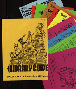
Booklet, Ballarat College of Advanced Education Library Guide, c1985, c1985
Ballarat College of Advanced Education is a predecessor institution of Federation University Australia. Yellow covered cover containing inserts relating to the Ballarat College of Advanced Education Library at Mount Helen. The artwork is by Henry Moritz of the Faculty of Arts.mt helen library, e.j. barker library, ballarat college of advanced education, library, librarians, law collection, audio-visual collection, deakin collection, geology collection, catalogues, microfiche catalogue, card catalogue, inter-library loans, film, loans, reciprocal borrowing, counter reserve, technical services, weeding, cataloguing, library policies, donations, library plan, periodicals, dewey decimal classification -
 Federation University Historical Collection
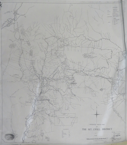
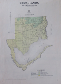
Map, Broadlands, County of Dargo, 1887
... broadford j.g. easton DARGO GEOLOGICAL Plan of Broadlands, County ...Plan of Broadlands, County of Dargo, Victoria.broadford, j.g. easton, dargo, geological -
Bendigo Historical Society Inc.
Book - MINING IN BENDIGO COLLECTION: BOOK - CAN WE HELP YOU?
Small, faded greenish book titled 'Can We Help You?' issued by Geo. Brown, Secretary for Mines under the authority of The Hon. H. E. Bolte, M. L. A., Minister of Mines. Mines Department Melbourne, Victoria 1949,(Sixth Edition). Printed by J. J. Gourley, Government Printer, Melbourne. In the front of the book is a Plan showing location of Mines Department Head Office, Geological Museum & Laboratory. Book is set out in a question and answer format. Book covers subjects on mininng and petroleum leases and licences.book, book, can we help you?, geo brown, the hon h e bolte, mines department melb, j j gourley, mines department head office geological museum & laboratory, royal mint melbourne -
Bendigo Historical Society Inc.
Book - 'BULLETINS OF THE GEOLOGICAL SURVEY OF VICTORIA NO. 30'. THE PEARL AND HERCULES AND ENERGETIC MINES, BENDIGO, 1914
Bulletins of the Geological Survey of Victoria No. 30. The Pearl and Hercules and Energetic Mines, Bendigo, with plans and sections. By W. Baraganath Underground maps of the 4 (four) mines referred to in this book. Priced six pence Inscribed on the front cover: A. Richardson, 29 Harrison Street, Bendigo.Department of Mines. By W. Baraganathbendigo, mining, early history., mining, pearl, hercules and energetic mines. -
Bendigo Historical Society Inc.
Document - STRUCTURE OF BENDIGO GOLDFIELD BULLETIN NO. 47
Booklet, 36 pages, that describes the structure of the Bendigo Goldfield. Booklet is enclosed in an envelope. On front of booklet : 1923 Victoria, Department of Mines, Bulletins of the Geological Survey of Victoria, W. Baragwanath, Director. Structure of Bendigo Goldfield, by H. Herman, late Director of Geological Survey. Maps under catalogue number 3769 accompanied the booklet and are listed as 'plates' on the contents page. Plans and Sections to accompany Bulletin No 47, Structure of Bendigo Gold-Field, by H Herman, B.C.E., M.M.E., F.G.S., late Director of Geological Survey.Geological Survey of Victoriabendigo, gold mining, structure of goldfield, bendigo, goldfield, gold mining, geology -
Bendigo Historical Society Inc.
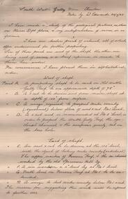
Map - HUSTLER'S & CHRISTMAS LINES OF REEFS - PLAN OF LINES OF SECTION OF REEFS
Underground Survey of Mines Bendigo. Plan of Cross Section Lines Shewing Connections with Trigonometrical Stations and Base Lines. 13/3/99 Signed ? Stirling. Places and mines mentioned Speciman Hill, Tambour Major, Lansell's 180, Victory and Pandora, Great Extended Hustler's, Windmill Hill on Victoria Reef. Next part of map is a Plan of Lines of Section between the Hustler's and Christmas Lines of Reefs. 8/3/99. Signed ?. Transverse Section. Shows Tambour Major Co., near the Christmas Line of Reef, Crosscuts and their depth, geological features and stone encountered. Then shows Thistle Line, Charshalton Line, Napoleon Line, Nell Gwynne Line, New Chum Line, Lansell's No 180 with levels, depths and geological features. Drawing is continued in three parts to fit on paper. Lansell's East Shaft with levels and depths, geological features and stone encountered. Sheepshead Line, Old Shaft, Garden Gully Line, Victory and Pabndora Co with crosscuts, depths, geological features and stone encountered. Paddy's Gully Line, Derby Line, Millers Line, Hustler's Line, Great Extended Hustler's Co with levels, depths, geological features and stone encountered. A note beside a Saddle Reef: 360,000 pounds paid in dividends from this reef. Average ounces per ton gold noted where found. Reference Table for stone and geological features. Datum Line 700 feet above Sea Level Unscannedmining, parish map, hustler's & christmas lines of reefs, plan of lines of section of reefs, ? stirling, specimen hill, tambour major, lansell's 180, victory & pandora, great extended hustler's, windmill hill, victoria reef, tambour major co, christmas line, hustler's line, thistle line, carshalton line, napoleon line, nell gwynne line, new chum line, lansell's no 180, lansell's east shaft, sheepshead line, old shaft, garden gully line, paddy's gully line, derby line, miller's line, hustler's line, great extended hustler's co -
 Bendigo Historical Society Inc.
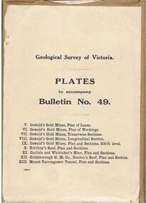
Book - MCCOLL, RANKIN AND STANISTREET COLLECTION: PLATES TO ACCOMPANY BULLETIN NO.49 MALDON GEOLOGICAL SURVEY OF VICTORIA
Book; Brown paper containers with plates (& maps) to accompany bulletin No49 of geological survey of Victoria. V Oswalds G.M. Plan of lease. VI. Oswalds G. M. Plan of workings. VII. Oswalds G. M. Transverse Sect. VIII. Oswalds G. M. Longit. Section. IX. Oswalds G. M. Plan & Sect. 500ft. Level. X. Northey's Reef plan & sections. XI. Carlisle and Whittaker's Mine Plan & Sections.XII. Goldsborough G. M. Co. Gordon's Reef, Plan & Section. XIII. Mount Tarrengower Tunnel Plan & Section.MCCOLL RANKIN & STANISTREETorganisation, industry, surveys, mccoll rankin & stanistreet -
 Bendigo Historical Society Inc.
Map - STRUGNELL COLLECTION: HUSTLER'S LINE OF REEFS, September 1913
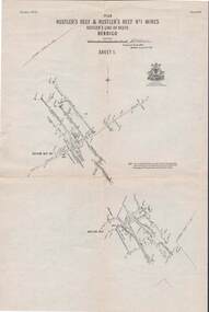
Map, Hustler's Line of Reefs, Hustler's Reef & Hustler's Reef No.1 Mines, Plan view . Plate No. XV (15).Sheet 1 Bulletin No. 33. Included is the emblem of the Geological Survey of Victoria. Signed by H.A.Whitelaw Underground Survey Office, Bendigo, Septembe ,1913.Underground Survey Office, Bendigo.map, bendigo, hustler's reef & hustler's reef 1 -
 Bendigo Historical Society Inc.
Map - STRUGNELL COLLECTION: HUSTLER'S LINE OF REEFS, September 1913
Map, Hustler's Line of Reefs, Hustler's Reef & Hustler's Reef No.1 Mines Plan.Plate No. XV1.(16) Sheet 2 .Bulletin No 33 Signed H.A.Whitelaw.Underground Survey Office, Bendigo, September,1913. Included is the emblem of the Geological Survey of Victoria. Drawing shows a plan view of reefs and shaft locations .Underground Survey Office, Bendigomap, bendigo, hustler's reef & hustler's reef 1 -
Stawell Historical Society Inc
Map, Stawell Gold Mine, Provisional Plan Wonga Area, c1980
c1980 Preliminary Provisional Reconnaissance Plan Showing Workings Above and Below water LevelWonga Area 1:1000 Base Geological Sheet mining, gold, map -
Koorie Heritage Trust
Book, Baragwanath, W, Memoirs of the Geological Survey of Victoria : No. 15 The Aberfeldy District, Gippsland, 1925
15 v. : ill., plates, maps, plans, diagrs. ; 34 cm. lcsh: 1. geology -- victoria -- periodicals. 2. geology -- victoria. i. geological survey of victoria. ii. victoria. dept. of mines. -
 Rutherglen Historical Society
Map, 1908
This is a map produced as part of a book entitled.. It is also stamped on the back in blue ink with an oval ring and the words North of England Institute. Newcastle. Mining & Meterolgical Faculty. Purchased on 23rd July 2017 by the Society after research by member Simon Killeen. Mining map of one of the first mines in Rutherglen area ( Chiltern West)Cream paper, black printing, rectangle with a drawingGeographical Survey of Victoria, Memoir, No6. Plate XX Plan of Underground Workings CHILTERN VALLEY CONSOLS MINE, RUTHERGLEN, PARISH OF CHILTERN WESTgold, rutherglen, mining, chiltern, underground mine map, geological survey, reef drives -
 Bendigo Historical Society Inc.
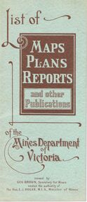
Document - LIST OF MAPS, PLANS, REPORTS PUBLISHED BY MINES DEPARTMENT VICTORIA 1938
Blue booklet, on front ' List of Maps, Plans, Reports and other publications of the Mines Department of Victoria. Issued by Geo Brown Secretary for Mines under the authority of The Hon. E.J. Hogan, MLA, Minister of Mines. Booklet contains list of publications of geological reports, maps etc for Ararat, Ballarat, Beechworth, Bendigo, Castlemaine, Gippsland, Maryborough.Geo Brown, Secretary for Mines under the authority of The Hon.E.J. Hogan, M.L.A. Minister of Mines.organisation, government, geological maps list -
 Bendigo Historical Society Inc.
Document - KANGAROO FLAT GOLD MINE COLLECTION: MEMO TO SANDNER FROM WILLMAN
Two page memo 17 January 1984, to R. Sandner, D. Cahill, R. Cameron, P.Vail and D. Andrew from C.E. William. Topics covered: Deborah lease project; Brunswick Mine Costerfield, E.L's 1397 and 1398; town planning permit application; historical research and geological assessment, dewatering programme.bendigo, gold mining, deborah lease project -
 Bendigo Tramways (managed by the Bendigo Heritage Attractions)
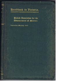
Reference Book, Albert J. Mullett, Government Printer, Melbourne, Handbook to Victoria- British Association for the Advancement of Science, CIRCA 1914
1914 Handbook prepared for the members of the "British Association for the advancement of science" on the occasion of their visit to Victoria, under the direction of the Victorian Executive Committee. Hard covered green handbook, gold leaf lettering. Printed text with Illustrations, Maps, Plans and Diagrams.Stamped: "WITH THE COMPLEMENTS OF THE GOVERNMENT STATIST." victoria, 1914, education, population, immigration, mining, geology, land, law, government, forestry, maps, public works. -
Tarnagulla History Archive
Set of Maps (Mining & Local Area), various
David Gordon Collection. A set of mining documents, maps and plans: 1. Dunolly Deep Leads - showing location and names of deep lead gold deposits in region around Dunolly including at Tarnagulla and Newbridge. Geological Survey of Victoria, Department of Minerals and Energy. Bulletin No. 62, Map No. 4 Dunolly (770 x 485 mm). 2. Poseidon Lead (Facsimile) 3. Nick O Time Lead (Facsimile) 4. Happy Go Lucky Mine prospectus and plan (colour copy) 5. Jones Creek GM Co. (Raven & Gourlay's) Waanyarra - Prospectus (colour copy) 6. Poseidon Area Plan (colour copy) and Poseidon Area map (B&W copy). 7. Cross-section diagram of Spread Eagle Reef 8. New Birthday Gold Mine - area map (colour copy) and mine cross-section ( (colour copy). 9. Cross section of Poverty Reef, by Department of Mines (B&W copy, 2 parts on A2 paper) 10. Time-Lease Graph for Watts Reef, Specimen Reef, Stony Reef, Poverty Reef (second page in detail), created by Eric WIlkinson for Ref Mining NL, 1995 11. 1859 Plan of the Gold Workings & Township of Sandy Creek, Shewing the Mining Leases, Extended Claims & Machinery by R.J. McMillan, Mining Surveyor (B&W copy) 12. Longitundinal and Transverse Vertical Sections of Poverty Reef, Sandy Creek 1859, by R.J. McMillan, Mining Surveyor (B&W copy) 13. Tarnagulla Locality Plan (B&W copy) 14. Universal Grid Reference Map (Topographic) for Laanecoorie North (2 copies) 15. Universal Grid Reference Map (Topographic) for Inglewood South 16. Poverty Reef, Plan showing shafts and early tenements, created by Eric WIlkinson for Ref Mining NL, 1995 17. Locality Map of mining leases in Tarnagulla 18. Plan and Elevation of part of Poverty Reef, Sandy Creek, showing the claims and positions of the shaft. by R.J. McMillan, Mining Surveyor (Facsimile, composed of taped together components) 19.Plan and Elevation of part of Poverty Reef, Sandy Creek, showing the claims and positions of the shaft. by R.J. McMillan, Mining Surveyor (Facsimile, composed of taped together components) -
 Bendigo Historical Society Inc.
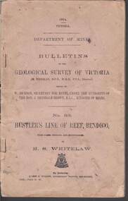
Book - STRUGNELL COLLECTION: DEPARTMENT OF MINES: 1914 GEOLOGICAL SURVEY OF VICTORIA. HUSTLERS LINE OF REEF, 1914
Book, Department of Mines, Bulletins of the Geological Survey of Victoria, No.33, Hustler's Line Of Reef, Bendigo, with plans,sections, and photographs, by H.S.Whitelaw. 13833, Price 2s.6d.`Back cover shows J.A. and J.A Strugnell , 12 Mulbar St Swan Hill 3585 .Albert J. Mullett, Government Printer, Melbourne.book, bendigo, hustler's line of reef -
 Bendigo Historical Society Inc.
Administrative record - South Wattle Gully Mine Chewton, W. Edwards, May 1934
Three page handwritten report. On top of first page: ' South Wattle Gully Mine, Chewton, notes by W. Edwards 20/7/65'. Edwards has 'made a study of the geological features, as shown on Mines Dept. plans' and his interpretation of same is discussed in the following areas: west of shaft; east of shaft and lode and gold occurrences. Report is part of the Margaret Roberts Mining Collection. bendigo, margaret roberts, goldmining, south wattle gully gold mine, w. edwards -
Bendigo Historical Society Inc.
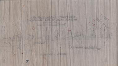
Map - SECTIONS ACROSS BENDIGO GOLDFIELD
... above sea level. On bottom of plan: ' Prepared... sea level. On bottom of plan: ' Prepared in the Geological ...Map in three sections showing sections across Bendigo Gold Field, showing anticlines, synclines, faults, stratigraphical zones and mines along the reef lines. Key shows rock types Castlemaine, Bendigo B1, B2, B3 and B4, and Lancefieldian. First part of map shows sections A-A, B-B and C-C. Reef lines drawn with mines listed: Fault line shown are the Carshalton, Stafford, New Chum, Virginia and Clarence. A datum line shows 600 ft above sea level. On bottom of plan: ' Prepared in the Geological Survey Office, Bendigo, under the direction of H. Herman, late Director of Geological Survey, from surveys by H.S. Whitelaw, Field Geologist, assisted by E.S. Usher, A.J.J. Moore and R.A. Keble.' Second section of map shows sections D-D, and E-E. Fault lines listed are the Tambour Major fault, Carshalton fault, Stafford fault, Nell Gwynne fault, New Chum fault, Deborah fault. Third section shows sections F-F and G-G. Fault lines listed are the Bird Reef fault, Kangaroo Gully fault, Langdon fault, Carshalton fault, Nell Gwynne fault, Spring Gully fault, Hustlers fault, Gravel Hill fault, Ordes fault, Thanet fault. This map forms part of the Geological Survey of Victoria, Structure of Bendigo Goldfield report, No. 47, 1923. H.Herman, late Director of Geological Survey.Geological Survey of Victoriabendigo, gold mining, reef line maps -
 Federation University Historical Collection
Map, Ballaarat Gold Field, 1861, 1861
A party of surveyors camped by Yuille's Swamp (later Lake Wendouree) and surveyed the countryside for a map to be produced by the Geological Survey of Victoria. In November 2004 the Central Highlands Regional Library presented a special edition of 200 copies of the 1861 map reproduced from a copy in their collection. Original 1861 map of Ballarat showing streets and leads. Blue dots indicate gold leads, and red lines indicate auriferous quartz reef and outcrops of quartz veins."Compiled & Drawn from the Survey of Mining Surveyors Davidson, Fitzpatrick and Cowan & the Plans in the Surveyor General's Office by J. Brahe, 21st October 1861. R. Brough Smyth, Secretary for Mines. The Honourable J.B. Humffray, M.L.A. Commr of Mines.”ballarat, map, ballarat east, lake wendouree, survey, mines, robert davidson, ballarat gold field 1861, yuille's swamp, wendouree swamp, little bendigo diggings, gold leads, old post office hill, specimen hill, bakery hill, black hill, dead horse creek, brown hill, pennyweight hill, clayton hill, soldiers hill, golden point, gum tree flat, white flat, poverty hill, chinese village, robert brough smyth, ballarat map 1861, ballaarat vineyard, dead horse gully, deadhorse creek, invermay, black hill flat, gaelic church, police reserve, magpie range, dalton's flat, caadian lead, rifle butts, powder magazine, bathing house, government camp, gold office, chinese, llanberrris, victoria theatre, charlie napier hotel, united states hotel, grape's hoel, clayton's hill, cattleyard hill, free trade hotel, esmond lead, bakery hill, black hill lead, juvenile reformatory, ballarat orphanage, lady barkly lead, triffet's slaughter yard, little bendigo, melbourne road, t. cowan, thomas cowan -
 Bendigo Historical Society Inc.
Document - MCCOLL, RANKIN AND STANISTREET COLLECTION: THE SEDGWICK GOLD MINE, 1930's
Manilla Folder containing documents relating to the Sedgwick Gold Mine, formerly the Great Eastern. Including plan of area applied for lease No. 10414 by E. Peel. Comprehensive hand written description of mine from R. M. Williams. And record taken from the Bendigo office by J. Caldwell, Field GeologistMcColl Rankin & Stanistreetgold mining, miners' safety cage, sedgwick, gold mine, sedgwick, great eastern, geology -
 Federation University Historical Collection
Map, Ballaarat Gold Field, 1861, 21/10/1861
A party of surveyors camped by Yuille's Swamp (later Lake Wendouree) and surveyed the countryside for a map to be produced by the Geological Survey of Victoria. In November 2004 the Central Highlands Regional Library presented a special edition of 200 copies of the 1861 map reproduced from a copy in their collection. Original geological map of Ballarat showing property, waterways, mines, churches, schools, water races, and garden reserves. It was compiled and drawn from the surveys of Mining Surveyors Davidson, Fitzpatrick and Cowan.Compiled & Drawn from the Survey of Mining Surveyors Davidson, Fitzpatrick and Cowan & the Plans in the Surveyor General's Office by J. Brahe, 21st October 1861. R. Brough Smyth, Secretary for Mines. The Honourable J.B. Humffray, M.L.A. Commr of Mines.ballarat, map, davidson, robert brough-smyth, fitzpatrick, cowan, yuille's swamp, public garden reserve, manure depot, black hill, ballarat east, old post office hill, pennyweight hill, claytons hill, golden point, mining, railway, cricket ground, swamp creek, cemetery, sludge reserve, bakery hill, gaelic church, juvenile reformatory, orphanage, specimen hill, eureka lead, cattle yard hill, dalton's flat, chinese village, poverty hill, railway reserve, little bendigo diggings, pound reserve, allied armies, flour mill, agricultural reserve, marsh, survey reserve, survey corps, white flat, yarrowee, yarrowee creek, brache, j. brache, survey, ballaarat gold field 1861 -
 Bendigo Historical Society Inc.
Map - RED WHITE & BLUE EXTENDED - PLAN OF RED WHITE AND BLUE EXTENDED MINE TRANSVERSE SECTION
Transverse section of the Red White & Blue Extended Mine on the Sheepshead Line of Reef showing shafts, depths and geological features. Drawn on tracing film in pencil. Signed by J J Caldwell, District Field Geologist, Mines Department, Bendigo and dated 5/12/1940. Notes prepared by Albert Richardson.document, gold, red white & blue extended, red white & blue extended, plan of red white & blue extended mine transverse section, j j caldwell, mines dept bendigo -
 Bendigo Historical Society Inc.
Document - MINING REPORTS - MINING REPORTS BY A RICHARDSON
Handwritten reports dated May 1968 by A. Richardson. On the 4th May visitors from Hobart toured the Central Nell, Victoria and New Chum Hill areas. Also on the 4th, a visit from Mr Geo Lambert who gave him a geological report of the Victoria Hill area. On the 13th May, a visit from Mr K W Smith who showed him slides of derelict W. A. mines. Also plans for the preservation of Mining in Bendigo at Victoria Hill and the preservation of the Central Nell Gwynne poppet legs.document, mining reports, mining reports by a richardson, mr geo lambert, hon j c balfour, mr n wakefield, mr k w smith, le fevre boy's tech high school, mrs f leak, mr perry, gt extended hustlers, central nell gwynne, the pioneer, gunther & party, lansell's fortuna, mt alvernia hospital, a richardson, devonshire mines, bendigo & district tourist association, mrs checcucci, mr jackman, mr greenway, r a c v, cl gerry, eureka extended, bendigo branch historical society -
 Bendigo Historical Society Inc.
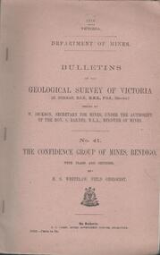
Book - MINING REPORTS - THE CONFIDENCE GROUP OF MINES BULLETIN NO 41
Light brown covered booklet 'Bulletins of the Geological Survey of Victoria issued by W Dickson, Secretary for Mines, Under the Authority of the Hon. S Barnes M L A Minister of Mines. No 41 The Confidence Group of Mines, Bendigo with Plans and Sections by H S Whitelaw, Field Geologist, dated 1918. Mines mentioned are: Confidence Extended Mine, Confidence Tribute Company and the Central Windmill Hill Mine. Mentioned in the report are crushings and gold yield, details of levels, names of leases along the reef. Extracts from Mine Manager's Half-yearly Reports, 1878-1915 of tons crushed and gold yield. Plans and sections of the Confidence Extended Mine on the Garden Gully Line of Reefs are: Plate I General Plan of All Levels, Plans of Levels Plate No II, Plans of Levels Plate No III, Transverse Section Plate No IV, Longitudinal Section Plate No V, and Central Windmill Hill Mine Transverse Section Plate No VI. Plates signed by H S Whitelaw 17 & 18/6/16 and 20/7/16. Booklet if part of the Albert Richardson Collection. book, bendigo, mining reports, mining reports, the confidence group of mines bulletin no 41, confidence extended mine, confidence tribute company, central windmill hill mine, department of mines, bulletins of the geological survey of victoria, w dickson, the hon s barnes, h s whitelaw, h j green, mr robert eddy, mr w h cundy, j foster, c j thompson -
University of Melbourne, Burnley Campus Archives
Plan, Maplist: Catalogue of Victorian maps, 1984
Brochure showing all standard series mapping in Victoria available from Map Sales Centre as at October 1984. Includes: Geographic, Geological Planimetric, Aerial Photography, Photo Maps.maps, catalogue