Showing 80 items matching "gold mining locations"
-
 Bendigo Historical Society Inc.
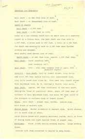
Plan - MARKS COLLECTION: LEASE PLANS GREAT SOUTHERN GOLD MINE BENDIGO
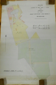
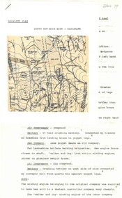
Plan on heavy paper, tightly rolled. On top of plan "Plan of Leases 5429, 4810, 4811 and 5429", The Property of the Great Southern Gold Mining Co. Bendigo' \Total area123 acres, 3 roods, 33 perches, excised, nett area 122, 0. 38. On bottom '32 feet to one inch' and 'This plan was devised from Government Mining Lease Plans and from actual survey' Signed E.F Brown, certificated mining and authorised surveyor 25/6/87' Leases No. 5429 and 4810 details location of shaft, tramway, battery, engine house and boiler. Large mining dam outlined.bendigo, mining, great southern gold mine -
 Bendigo Historical Society Inc.
Document - LANSELL'S BIG 180 MINE - CONDENSED HISTORICAL RECORD OF LANSELL'S BIG 180 MINE
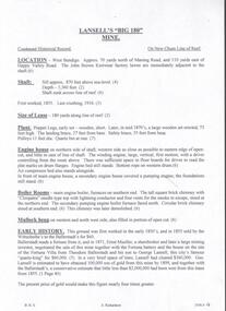
Two handwritten and three typed copies of a Condensed Historical Record of Lansell's Big 180 Mine on the New Chum Line of Reef. Notes include location, shaft, first worked, size of lease, plant, engine house, boiler rooms, mullock heap, early history, Prominent, best gold, underground connections, pressurised hot water, diamond drill bores and a table with depths and the increase in temperature with the depth (in Fahr). Albert Richardson Collection. document, gold, lansell's big 180 mine, lansell's big 180 mine, condensed historical record of lansell's big 180 mine, wittscheibe, ballerstadt, ernst mueller, theodore ballerstadt, george lansell, north old chum, victoria quartz, mines dept special edition 'australian mining standard' 1/6/1899, mines dept booklet 'bendigo goldfield' 1936, quarterly reports, lansell's 180 mine 'transverse sections, annals of bendigo mining sections, a richardson's observations from old photographs and measurements of mining plans, measurements taked from caleb thomas' report mines dept 1875, 'report on observation of underground temperature at bendigo' james stirling government geologist 1899, a richardson -
 Bendigo Historical Society Inc.
Document - MINING REPORTS - LOCATION OF SHAFT WITH THE REEF
... BHS Collection DOCUMENT Gold mining reports Mining Reports ...BHS CollectionHandwritten list by Albert Richardson, with typed copy, of mines on the Garden Gully, Sheepshead, Hustlers, Nell Gwynne and the Deborah, Paddy Gully and Derby Lines of Reef. Also a list of prominent mines on the New Chum Line. document, gold, mining reports, mining reports, location of shaft with the reef, north new moon, suffolk, new moon, south new moon, clarence, new argus, virginia, gt northern golden pyke, constellation, johnsons extd, golden age, princess dagmar, johnson's no 2, nth johnsons, johnsons no 1, confidence extended, windmill hill, koch's pioneer, cornish, carlisle, pandora, garden gully united, catherine reef united, williams united, belmont & saxby, ellenborogh, st mungo, sadowa, lady barkly, south st mungo, united devonshire, south devonshire, pearl, hercules & energetic, ironbark (vict gold mines), victoria consols, victoria quartz (vict reef), lansell's big 180, north old chum, new chum & victoria, old chum, lazarus, 222, new chum united, new chum consolidated - the consolidated, garibaldi, shamrock, hercules, ironbark, south ironbark, little 180, central blue, sheepshead, nth blue, big blue, south blue (lansell's), united hustlers & redan, the redan, comet (lansell's), hustlers reef plus no 1 shaft, old hustlers, gt extended hustlers plus 'pups', royal hustlers reserve nos 1 & 2, fortuna hustlers, new chum syncline, central nell gwynne, monument hill, central deborah, north deborah, deborah, collman &tacchi, lansells sandhurst needle, johnsons no 3 (nelsons) -
 Bendigo Historical Society Inc.
Document - MINING REPORTS - KING OF PRUSSIA MINE
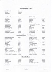
KING OF PRUSSIA MINE WHIPSTICK ROAD EAGLEHAWK NORTH, GREATER BENDIGO CITY Place ID 8444 Location WHIPSTICK ROAD EAGLEHAWK NORTH, GREATER BENDIGO CITY Municipality GREATER BENDIGO CITY Heritage Listing Victorian Heritage Inventory Level of significance Heritage Inventory Site Heritage Inventory (HI) Number H7724-0141Brief handwritten notes by Albert Richardson, with typed copy of same, on the King of Prussia Mine on the Lightning Hill Line. Notes give the depth, crushings, gold yield, commenced 1876 and closed 1877.gold, mining reports, mining reports, kinf of prussia mine, b m l production statistics -
 Bendigo Historical Society Inc.
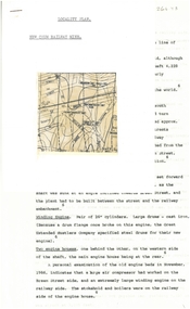
Document - ALBERT RICHARDSON COLLECTION: NEW CHUM RAILWAY MINE, GOLDEN SQUARE
Three-page typed document plus map. Document details location and history of the New Chum Railway Mine, Golden Square and includes: depth of shaft, size of lease, locality, poppet legs, winding engine, engine houses, crushing battery, best gold obtained, prominence, and total gold production and dividends. References provided. Document forms part of research referred to in Albert Richardson's paper 2264.70.bendigo, mining, new chum railway gold mine -
 Bendigo Historical Society Inc.
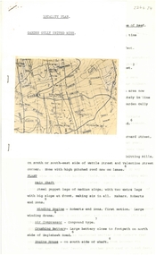
Document - ALBERT RICHARDSON COLLECTION: GARDEN GULLY UNITED MINE
Three-page typed document plus map showing location of the Garden Gully United Mine. The history and features of the mine operation are described and include: the locality of the shafts, winding engine, air compressor, crushing battery, engine house, gold obtained and dividends and gold production. The lookout tower in Rosalind Park was formerly the poppet legs of the Garden Gully United Gold Mining Company. Albert Richardson writes: ' a fitting tribute to Bendigo's most famous goldmine. The four-legged lookout tower was originally the six-legged poppet legs of the Garden Gully United.bendigo, mining, garden gully united mine, gold mining, poppet legs, rosalind park -
 Bendigo Historical Society Inc.
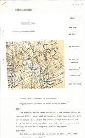
Document - ALBERT RICHARDSON COLLECTION: FORTUNA HUSTLERS MINE
Two-page document with location map. The Fortuna Hustlers Gold mine was located close to the railway goods shed (Discovery Centre location) in an area occupied by Buckell and Jeffrey's office and yards. (now carpark of Marketplace shopping centre). It commenced operation in August 1888 and closed in December 1913.The depth of the shaft was 2,240ft. Features of the plant described are: the winding engine, the air compressor, boilers, baling tanks, poppet legs, engine house. The winding engine later worked at the Tambour Major at Specimen Hill; Birds Reef at Kangaroo Flat, Hercules No. 1 on top of Danger Hill and the North Virginia mine at Eaglehawk.bendigo, mining, fortuna hustlers mine -
 Bendigo Historical Society Inc.
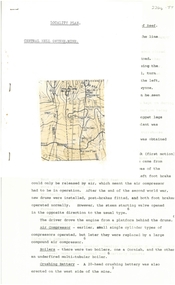
Document - ALBERT RICHARDSON COLLECTION: CENTRAL NELL GWYNNE MINE
Two-page typed document plus location map. The Central Nell Gwynne gold mine was located off Happy Valley Road, first turn to the left from Marong Road, and up on the hill. The shaft depth was 1,912 ft. The original plant had small wooden poppet legs and a steam winch which were replaced, in 1935/36 by steel poppet legs obtained from the Virginia mine at Eaglehawk. Features and history of the plant are described including the winding engine, air compressor, boilers, and crushing battery. The dividends and gold production figures are given. The total yield of gold was 61,884 oz.bendigo, mining, central nell gwynne -
 Bendigo Historical Society Inc.
Document - ALBERT RICHARDSON COLLECTION: CENTRAL RED, WHITE AND BLUE MINE
Two-page typed document plus location map. The location of the Central Red, White and Blue mine was on the north-west corner of Barnard and Honeysuckle Streets, Golden Square. The mine was formed in 1910 and ceased operations in 1936. Features of the mine are described: the winding engine, boilers, air compressor, poppet legs, engine house, crushing battery, gold produced and where obtained from. 'The rich gold yields which made this mine so prominent in its early years, was obtained from a large reef at the 318 feet level, some yields reached as high as 15 oz to the ton'.bendigo, mining, central red, white & blue mine -
 Bendigo Historical Society Inc.
Document - ALBERT RICHARDSON COLLECTION: HISTORICAL RECORDS OF BENDIGO MINES
Copy of 3-page handwritten document by Albert Richardson. Written on top of page one: 'Mining Report Historical Society 6.7.67. Historical Records of Bendigo Mines' which outlines a project undertaken by Albert and the Historical Society to write a description of each Bendigo mine, showing location, plant, gold gained, depth of shaft etc. The objective was to publish this information in a book for 'educational and historical purpose'. The paper further describes a public meeting to outline the BHS proposal to 'preserve a gold mine with all equipment both surface and underground, a crushing battery, a windlass, a whip and a whim to be stored, as far as possible in correct position. For tourists, local residents and educational purposes this should illustrate what Bendigo workers in Bendigo foundries and Bendigo citizens generally, achieved in making this city a world-famous gold mining centre. That Victoria Hill be made available and developed for the benefit of tourists and local residents' Members of the BHS involved: J. Hattam President, E. Clarke, Neil Murray, A. LLewellyn.bendigo, mining, bendigo gold mines -
 Bendigo Historical Society Inc.
Document - ALBERT RICHARDSON COLLECTION: NEW RED, WHITE AND BLUE CONSOLIDATED MINE, GOLDEN SQUARE
Two-page document plus map showing location of the New Red, White and Blue Consolidated mine on the Sheepshead Line of Reef. Information on the mine is given in the following areas: location plant, early history, its role as a leading mine, its prominence, its closure, gold production. References are provided. Document forms part of research referred to in Albert Richardson's paper 2264.70.bendigo, mining, new red white and blue mine -
 Bendigo Historical Society Inc.
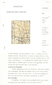
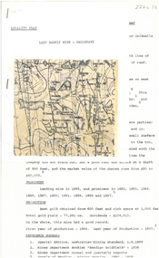
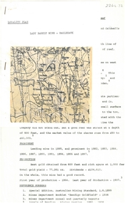
Document - ALBERT RICHARDSON COLLECTION: LADY BARKLY MINE, EAGLEHAWK
One page document, plus map, with information on the Lady Barkly Mine, New Chum line of reef, Eaglehawk. The location, early history, prominence, and gold production are described. References given on bottom of document. Document forms part of research referred to in Albert Richardson's paper 2264.70.bendigo, mining, lady barkly mine eaglehawk -
 Bendigo Historical Society Inc.
Document - ALBERT RICHARDSON COLLECTION: SOUTH NEW MOON MINE EAGLEHAWK
Two-page typed document with map, detailing information on the South New Moon Gold Mine on the Garden Gully line of reef. Information includes the location, depth of shaft, steel poppet legs, engine house, air compressor, battery, company ownership, battery. The shaft The 'Walker and Coy' winding engine of the later company together with poppet heads was removed later to the South Virginia company between Napier and Market Street, Eaglehawk. Gold production from both companies who owned the mine was 257,498 oz.'.bendigo, mining, south new moon gold mine -
 Bendigo Historical Society Inc.
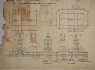
Plan - MARKS COLLECTION: PLAN FOR FOUR LEVEL STAIRCASE TOWER TO GARDEN ELEVATION AT FORTUINA VILLA FOR GEO. LANSELL ESQ
Fortuna Villa was owned from 1855 to 1871 by Christopher and Theodore Ballerstedt, Australia’s first mining magnates. In 1871 it was purchased by George Lansell (The Quartz King) being one of Australia’s most successful and adventurous nineteenth century gold mine owners and speculators. Lansell made numerous alterations and extensions to the building and it remained in the Lansell family until 1935.Plan for four level staircase tower to the Garden Elevation of Fortuna Villa, Sandhurst for George Lansell Esq. Plan details: * Plan shows ground, First, second and third floor plans for the staircase construction * First and second floor house plans and location of staircase addition * Front and Garden elevations with staircase addition Plan coloured and damaged on LHS, also with water damagebendigo fortuna villa, george lansell, building plans, c & t ballerstedt -
 Bendigo Historical Society Inc.
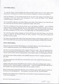
Document - VICTORIA HILL - VICTORIA HILL AND NEW CHUM HILL
Typed notes on Victoria Hill and New Chum Hill. Notes give location, value of gold and plans for a mining museum.document, gold, victoria hill, victoria hill and new chum hill, john neil macartney, the age, the australasian, bendigo goldfields registry 1871, victoria reef quartz mine, north old chum, victoria consols, new chum and victoria, pioneer, lansell 222 mine, lazarus, barnet lazarus, mt. alvernia hospital, fortuna villa, george lansell, a. h. q. survey regiment, central red white and blue, hudsons, burrowes & sterry, b c v channel 8, bendigo and district tourist association, section 14 of the lands act 1958, mr a r richardson, cr t r flood, tourist association -
 Bendigo Historical Society Inc.
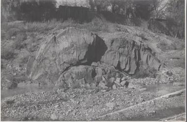
Photograph - Napoleon Anticline, 1935
In structural geology, an anticline is a type of fold that is an arch-like shape and has its oldest beds at its core, whereas a syncline is the inverse of an anticline. A typical anticline is convex up in which the hinge or crest is the location where the curvature is greatest, and the limbs are the sides of the fold that dip away from the hinge.Significant to mining history of Bendigo.Black and white photograph: rock formation, anticline with an archlike shape in centre of image. Written in pencil on back of photograph : 'Napoleon anticline Golden Square'.napoleon gold mine, anticline -
 Bendigo Historical Society Inc.
Document - HERCULES AND ENERGETIC MINES - NOTES ON THE HERCULES AND ENERGETIC MINES
Four typed copies of notes on the Hercules and Energetic Mines. Notes include Location, depth of shafts, plant and machinery, Early History and Prominence. Reference: Mines Dept Special Edition Australian Mining Standard 1.6.1899, Mines Dept Booklet Bendigo Goldfield 1936, Mines Dept Annual and Quarterly Reports, Annals of Bendigo Mining Sections 1876 - 1921, A Richardson, The Bendigo Goldfield Registry J N Macartney 1.3.1871, Mines Dept Bulletin No 30 h Herman 1914, Bendigo Amalgamated Goldfields Coy Financial Reports 1920. There are three typed copies, also the original handwritten notes.mine, gold, hercules and energetic mines, notes on the hercules and energetic mines, the north energetic, the victoria pilot, plan of leases of 1870, bendigo amalgamated goldfields company, sheepshead line, central blue, big blue, mines dept special edition australian mining standard 1.6.1899, mines dept booklet bendigo goldfield 1936, annals of bendigo mining sections 1876 - 1921, a richardson -
 The Beechworth Burke Museum
Photograph
This image is a reproduction of an 1899 original depicting the 'Williams Good Luck Mine' on the Mopoke Reef (also called 'Morepork Gully') in the Dingle Ranges, approximately three miles from Beechworth. A large opening to a mine can be seen behind the men in the photograph, with a wheeled cart on a track leading to the men's position, where the soil and rocks have been hauled away. This photograph interestingly contains dogs alongside the miners. While dogs have been recorded as deterrents to thieves in the Victorian goldfields, these dogs appear as companions to these men. Following the discovery of gold at Beechworth in 1852, rushes quickly followed at surrounding creeks and gullies in the district. In the late nineteenth and early twentieth centuries, small syndicates of miners continued to work old or abandoned quartz reefs, often persisting without the assistance of heavy machinery to remove the large amounts of rock, in order to obtain yields at ever greater depths. The group of miners in this photograph are Mr. Roger Williams and Sons, who revived operations at the ‘Old Good Luck’ mine on the Mopoke Reef in the Dingle Range near Beechworth around 1892, working the site for more than two decades. An emigrant from Cornwall with experience in the tin mining industry, 19 year old Roger Williams senior sailed to New Zealand in 1840, then to Australia where he spent time in the Bendigo Gold Fields before settling in Beechworth in the early 1860s. Mr Williams senior worked on various mining activities in the district, including the Rocky Mountain Tunnel project. Conversant with the character of gold-bearing reefs in the area, the syndicate dug an eight hundred foot tunnel, digging down as far down as two hundred feet with little capital save their labour, to connect and provide better working access to the mass of reefs and veins in the vicinity. Progress was hampered by poor air quality charged with fumes from dynamite and large quantities of rock had to be crushed to obtain payable yields. The Victorian Goldfields are filled with ruins and remnants of the area's rich mining history, ranging from small alluvial diggings to the remains of huge mining companies. Site names often changed several times throughout the nineteenth and twentieth centuries. Some sites were abandoned and forgotten, others were worked continuously over many decades. The names of mines were often repeated at different locations throughout the Victorian Goldfields. For example, there is a Mopoke Gully heritage mine near Fryers Creek, Victoria. 'Mopoke' is a common onomatopoeic name for Morepork and Australian Boobook owls.This image has historical, social and research significance for patterns of emigration during of the Victorian Gold Rush, and the historical, social and environmental impacts of mining at Beechworth at the turn of the nineteenth and twentieth centuries. As gold became scarce and government support and large company investment waned, poor hard-working miners laboured intensively to make a living through periods of high unemployment. This image can be compared and studied alongside other historical mining photographs and objects in the Burke Museum Collection. It has potential to improve our understanding of miners working conditions and the shifting character of mining in the Beechworth district.Sepia coloured rectangular photograph printed on gloss photographic paper mounted on card. Obverse: Williams/ Good/ Luck Reverse: A02498/ 1997. 2498/ Good Luck/ Mine/ 1899/ Mopoke. burke museum, beechworth museum, beechworth, gold fields, gold rush, victorian gold rush, gold ming history, colonial australia, australian gold rushes, mining technology, beechworth historic district, indigo gold trail, migration, indigo shire, good luck gold mine, victorian goldfields, mining syndicates, gold fever, quartz-mining, small-scale mining, old good luck mine, mopoke gully, quartz reefs beechworth -
 The Beechworth Burke Museum
Photograph
This image is a reproduction of an 1899 original depicting the 'Williams Good Luck Mine' on the Mopoke Reef (also called 'Morepork Gully') in the Dingle Ranges, approximately three miles from Beechworth. The foreground of the image is littered with piles of smashed rock and detritus, known as ‘mullock’, beside a reinforced mine shaft, a vertical access passageway allowing miners to enter the mine and haul ore out using lifting technology such as a poppet heads, whims or windlasses. A group of miners and a dog appear close to an open-sided miner’s hut. Following the discovery of gold at Beechworth in 1852, rushes quickly followed at surrounding creeks and gullies in the district. In the late nineteenth and early twentieth centuries, small syndicates of miners continued to work old or abandoned quartz reefs, often persisting without the assistance of heavy machinery to remove the large amounts of rock, in order to obtain yields at ever greater depths. The group of miners in this photograph are Mr. Roger Williams and Sons, who revived operations at the ‘Old Good Luck’ mine on the Mopoke Reef in the Dingle Range near Beechworth around 1892, working the site for more than two decades. An emigrant from Cornwall with experience in the tin mining industry, 19 year old Roger Williams senior sailed to New Zealand in 1840, then to Australia where he spent time in the Bendigo Gold Fields before settling in Beechworth in the early 1860s. Mr Williams senior worked on various mining activities in the district, including the Rocky Mountain Tunnel project. Conversant with the character of gold-bearing reefs in the area, the syndicate dug an eight hundred foot tunnel, digging down as far down as two hundred feet with little capital save their labour, to connect and provide better working access to the mass of reefs and veins in the vicinity. Progress was hampered by poor air quality charged with fumes from dynamite and large quantities of rock had to be crushed to obtain payable yields. The Victorian Goldfields are filled with ruins and remnants of the area's rich mining history, ranging from small alluvial diggings to the remains of huge mining companies. Site names often changed several times throughout the nineteenth and twentieth centuries. Some sites were abandoned and forgotten, others were worked continuously over many decades. The names of mines were often repeated at different locations throughout the Victorian Goldfields. For example, there is a Mopoke Gully heritage mine near Fryers Creek, Victoria. 'Mopoke' is a common onomatopoeic name for Morepork and Australian Boobook owls.This image has historical, social and research significance for patterns of emigration during of the Victorian Gold Rush, and the historical, social and environmental impacts of mining at Beechworth at the turn of the nineteenth and twentieth centuries. As gold became scarce and government support and large company investment waned, poor hard-working miners laboured intensively to make a living through periods of high unemployment. This image can be compared and studied alongside other historical mining photographs and objects in the Burke Museum Collection. It has potential to improve our understanding of miners working conditions and the shifting character of mining in the Beechworth district.Sepia coloured rectangular photograph printed on gloss photographic paper mounted on card.Obverse: Reverse: A02497/ 1997.2497/ 'Good/ Luck/ Mine'/ Morepork/ Gully/ Mrs Joyce/ Bright/ Tunnel/ 800 ft/ 1899. burke museum, beechworth museum, beechworth, gold fields, gold rush, victorian gold rush, gold ming history, colonial australia, australian gold rushes, mining technology, beechworth historic district, indigo gold trail, migration, indigo shire, good luck gold mine, victorian goldfields, mining syndicates, gold fever, quartz-mining, small-scale mining, old good luck mine, mopoke gully, quartz reefs beechworth -
 Clunes Museum
Map, DEPARTMENT OF MINES, Untitled, c1859
All maps show names and locations of mines operating in the district (see reference section link to article).1 Map of Creswick Clunes - lists 45 mines in the Clunes enlargement and 100 mines in the Creswick enlargement .2 Department of Mines map of Clunes Creswick and shows the McDonald & Co. Pre-emptive area. Indexes for quartz and alluvial mine locations .3 Topographical map Ref GF23 Clunes Mt. Greenock Talbot.1 360 Scale 1:2500 .2 303/59 33 hand written in ink "received 15 October 1859" signed by R Broughton, James Stevenson - District Mining Surveyor .3 40 chains to an Inchgold mining, dept of mines