Showing 73 items
matching goulburn district
-
 Rutherglen Historical Society
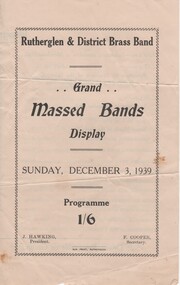
Documents, Sun Print, Grand Massed Bands Display, Sunday, December 3, 1939, 1939
The events of the afternoon included lunch for the bandsmen at the Memorial Hall, a street march to the Park, and performances at the Park, concluding with a massed march back to town. 10 bands from the surrounding districts participated. The donor was teaching at the Rutherglen Higher Elementary School at the time of this event, and boarded at the Star Hotel.Program for a massed bands display, held by the Rutherglen & District Brass Band, on December 1939. Also included is a letter from the donor.bands, rutherglen town band, wangaratta town band, mooroopna town band, corowa town band, albury town band, goulburn valley pipe band, yarrawonga brass band, finley district citizens band, beechworth town band, benalla citizens band, rutherglen higher elementary school, star hotel -
 Numurkah & District Historical Society
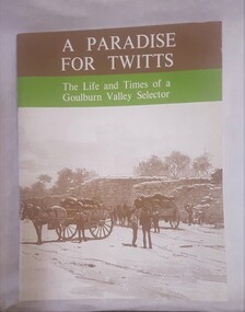
Book - Family History Book, A Paradise of Twitts
Book was written & published by ex-local, Adrian Twitt in 1974. Donated surplus books to H.S. for sale (& keep one copy)( Set of 18)Book with Brown, Green cover with sepia photo of horse & cart near a wheat-bag stack Title: A Paradise of Twitts, the life and times of a Goulburn Valley selector (Adrian Twitt, 1974)book, family history, settlement, twitt -
 Ambulance Victoria Museum
Photograph, Ambulance Officers Training School, Mayfield, Malvern, September 1964, 1964
Names of participants signed on reverse of photograph: Jim Mason, Goulburn Valley, Shepparton Trevor Jobling (?), Murray Valley, Swan Hill Alf Bainbridge (?), Glenelg Ambulance, Hamilton Keith Thomas, Victorian Civil Ambulance Service Ray Harris(?) , W.D.A.S., Horsham Stan Barnes, Geelong & District Ambulance Service Doug Harper (?), North Eastern, Wangaratta Jim Woolgoo (?), Penninsula, Dandenong Morrie Denham (?), St John, Adelaide Geoff Ryan, CVDAS, Bendigo Charlie James, Penninsula, Frankston Terry Edwards, V.C.A.S., Cheltenham Stewart Ferguson, Latrobe Valley, Morwell Ben Kingsley, V.C.A.S. Bert Cluff, Ballarat & District Ambulance Service Charlie Williams, South Gippsland, Korumburra Robert Stewart, V.C.A.S. Jack Bourke, Geelong Harold Berry, Training Officer Faye JamesonBlack and White photograph of ambulance officer trainees -
 8th/13th Victorian Mounted Rifles Regimental Collection
Photograph - Presentation of Hutton trophy
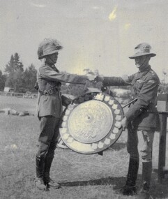
The Hutton Trophy or Shield was awarded annually to the best Light Horse Troop in Australia. The trophy is now held at the Armoured Centre Puckapunyal. Inter-regimental competition was strong in the years between WWI and WWII. Annually, the best troop in the regiments of the 3rd (Vic), 4th (SA), 5th (WA) and 6th (Tas) Military Districts competed for the Hutton Trophy and the Lord Forster Cup. The 20th Light Horse (Victorian Mounted Rifles) was raised in 1920 as part of the 3rd Cavalry Brigade, 2nd Cavalry Division, Citizen Military Forces, with Headquarters at Seymour and depots along the Goulburn Valley from Mansfield to Tocumwal in southern NSW. In December 1941, 20th Light Horse (Victorian Mounted Rifles) converted from horse to mechanised, initially as 20th Motor Regiment. In 1943 redesignated 20th Pioneer Battalion and deployed to Merauke, Dutch New Guinea. The regiment was disbanded at the end of the war, 1945. 20th Light Horse was the only light horse unit to serve overseas in WWII.No 1 Troop C Squadron 20th Light Horse Regiment drawn from the farming community of Tocumwal, personified the strength of citizen soldiering in rural Victorian and Southern NSW in the period following World War One and especially in the years immediately prior to the second World War. Building on the strength and enthusiasm of the Tocumwal Troop other Troops were raised at Finley, Berigan and Jerilderie. The Tocumwal Troop won the coveted Hutton Trophy in 1937 and 1938, defeating crack Troops from other States.Rare photograph of presentation of iconic RAAC trophy. Complements other items in the collection.Black and white photograph of two soldiers in Light Horse uniform with large trophy being Colonel G.A. Street MC presenting the Hutton Trophy to Sergeant H.G. Fyffe, troop leader of the Tocumwal Troop 20th Light Horse, winners of the 1937 competition. Sergeant Fyffe, later Captain Fyffe, 9th Division Cavalry Regiment served in North Africa and was awarded the Military Cross. hutton, light horse, fyffe, street, military, trophy -
 8th/13th Victorian Mounted Rifles Regimental Collection
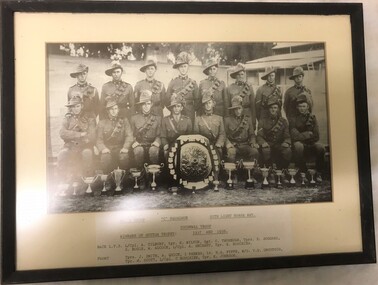
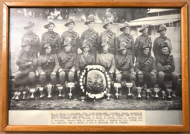
Photograph - 20th with Hutton shield
The Hutton Trophy or Shield was awarded annually to the best Light Horse Troop in Australia. The trophy is now held at the Armoured Centre Puckapunyal. Inter-regimental competition was strong in the years between WWI and WWII. Annually, the best troop in the regiments of the 3rd (Vic), 4th (SA), 5th (WA) and 6th (Tas) Military Districts competed for the Hutton Trophy and the Lord Forster Cup. The Tocumwal Troop were winners of the Hutton Shield in 1937 and 1938. The 20th Light Horse (Victorian Mounted Rifles) was raised in 1920 as part of the 3rd Cavalry Brigade, 2nd Cavalry Division, Citizen Military Forces, with Headquarters at Seymour and depots along the Goulburn Valley from Mansfield to Tocumwal in southern NSW. In December 1941, 20th Light Horse (Victorian Mounted Rifles) converted from horse to mechanised, initially as 20th Motor Regiment. In 1943 the Regiment was deployed to Merauke, Dutch New Guinea. Upon its return in April 1945, the Regiment was redesignated 20th Pioneer Battalion. It was disbanded following the end of the war. 20th Light Horse was the only light horse regiment to serve overseas in WWII.Framed black and white photograph of Tocumwal Troop 20th Light horse with the Hutton Shield and other trophies.No 1 Troop C Squadron 20th Light Horse Regt (Tocumwal Troop). Soldiers named.tocumwal, 20th, light horse, competition, hutton -
 8th/13th Victorian Mounted Rifles Regimental Collection
Photograph - 20th with Hutton shield
The Hutton Trophy or Shield was awarded annually to the best Light Horse Troop in Australia. The trophy is now held at the Armoured Centre Puckapunyal. Inter-regimental competition was strong in the years between WWI and WWII. Annually, the best troop in the regiments of the 3rd (Vic), 4th (SA), 5th (WA) and 6th (Tas) Military Districts competed for the Hutton Trophy and the Lord Forster Cup. The Tocumwal Troop were winners of the Hutton Shield in 1937 and 1938. The 20th Light Horse (Victorian Mounted Rifles) was raised in 1920 as part of the 3rd Cavalry Brigade, 2nd Cavalry Division, Citizen Military Forces, with Headquarters at Seymour and depots along the Goulburn Valley from Mansfield to Tocumwal in southern NSW. In December 1941, 20th Light Horse (Victorian Mounted Rifles) converted from horse to mechanised, initially as 20th Motor Regiment. In 1943 the Regiment was deployed to Merauke, Dutch New Guinea. Upon its return in April 1945, the Regiment was redesignated 20th Pioneer Battalion. It was disbanded following the end of the war. 20th Light Horse was the only light horse regiment to serve overseas in WWII.Framed black and white photograph of Tocumwal Troop 20th Light horse with the Hutton Shield and other trophies.No 1 Troop C Squadron 20th Light Horse Regt (Tocumwal Troop) ...tocumwal, 20th, light horse, competition, hutton -
 8th/13th Victorian Mounted Rifles Regimental Collection
Photograph
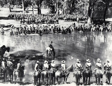
A rare photograph of massed Light Horse in Victoria shortly before mechanisation consigned the horse to history.Black and white photograph of large group of horsemen in ranks waiting in the process of watering horses at a lagoon. One copy of the image claims it to be 8th Light Horse Regiment watering horses at a Murray River lagoon, South Corowa NSW, September 1939; Wahgunyah Troop, C Squadron - this side of lagoon, Lieutenant J. Nott on grey horse in water. A second copy (Cat No 0690) asserts it is 4 regiments of light horse being 8th, 13th, 20th and 4th watering horses near Torquay Victoria, March 1940.On a label on reverse of 0690: "Picture taken about March 1940 when the 13th Light Horse from Gippsland, the 8th Light Horse from Upper Murray, the 4th Light Horse from the Western Districts and the 20th Light Horse from the Goulburn Valley were in camp near Torquay. Mr Cappur Webb of Glendoxey, Seymour, a member of the 20th said the picture must have been taken during and exercise about five miles north of Torquay. “We used to water our horses in that lake”, he said." -
 Maryborough Midlands Historical Society operating the Worsley Cottage Museum
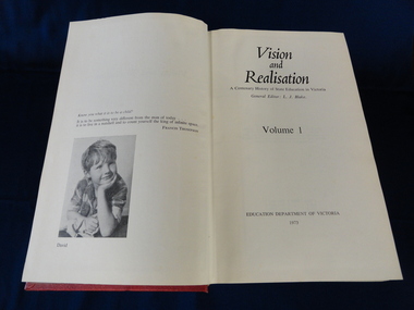
Books, Vision and Realisation, 1973
Information on Maryborough and district schools and their histories.Information invaluable as access to local school historic records is currently unavailable.A set of three hardcover (red) books detailing the history of education in Victoria. Volume 1 (general account of the development of education), Volume 2 (schools in the Wimmera, central Victoria and Geelong), Volume 3 (Melbourne, upper Goulburn, upper Murray, Gippsland regions). Published by the Education Department of Victoria. -
 Wodonga & District Historical Society Inc
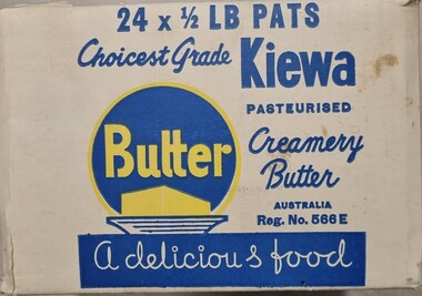
Functional object - Kiewa Dairy Box
The Kiewa Butter Factory began in 1893, named after the Kiewa River on which it is located. By 1905, butter shipped from Kiewa was receiving a top price of 114 s per cwt at the London market. It continued to prosper until 1959 when it merged with Tallangatta Butter Factory and Creamery Co. Ltd to become the North Eastern Dairy Company. In 1985 this organisation was taken over by the Murray Goulburn Co-operative.This package is representative of an important industry in Wodonga and the surrounding district.A packing box for butter from the Kiewa North Eastern Dairy. Made from heavy cardboard with blue and yellow design.On Front: 24 x 1/2 lb PATS / Choicest grade Kiewa/ Pasteurised / Creamery Butter/ AUSTRALIA / Reg. No. 566E/ BUTTER A delicious food On sides: 24 x 1/2 lb PATS / Choicest grade Kiewa/ Pasteurised / Creamery Butter/ AUSTRALIA / Reg. No. 566E/ North Eastern Dairy Co. Ltd. / KIewa Australianortheastern dairy co, dairies and butter factories, dairy industry victoria -
 City of Kingston
Photograph - Black and white, 20 December 1945
Cheltenham is a suburb in the City of Kingston that was originally established as a rural market gardening community. The area is bordered by Highett, Mentone and Heatherton. The market gardens, farms and paddocks have gradually been sub-divided into housing and industrial estates. The Southland shopping centre is a major feature of the area.Cheltenham was established as a rural market gardening community. The Le Page family lived in Cheltenham since 1854 when Nicholas Le Page, a tailor from the Channel Island of Guernsey, bought two acres of land on Chesterville Road near Bernard Street to establish a market garden. Over the years the Le Pages purchased more land in the area. In 1875-76 Nicholas' son Frank and his wife Mary built 'Daphne Cottage' near the corner of Bernard and Wilson Streets. n the 1940s Frank's son, Everest Le Page, bought five more lots of land in Chesterville Road from the Tuck family. The Le Pages grazed horses, ponies and cows on this land, and grew pumpkins, carrots, parsnips, onions, potatoes and cabbages. Many buildings and locations within in Cheltenham commemorate the Le Page family's contribution to the Cheltenham community.Aerial photograph taken in 1945 of the Cheltenham district within the City of Kingston. The image includes Chesterville Road, the future site of Turner Road pool (now Waves) and Highett Reserve, (top left), Jellicoe Street, Argus Street, Bernard Street, Wilson Street, the Methodist Children Homes (now Southland), McIvor Street, Goulburn Street, Nepean Highway, Jamieson Street and Barker Street (bottom left), market gardens and paddocks. In the top centre of the image, "Daphne Cottage", the home of Frank T. Le Page is visible on the corner of Bernard and Wilson Streets. Much of the land depicted in this image was owned by the Le Page family. This image is possibly from the collection of aerial photographs commissioned by the Department of Crown Lands and Survey and taken by Adastra Airways.Black and white ink: 57250 White print: VIC-170 57250 20.12.45 Run 6 PROJ. No. 5 MELB. METROP AREA Black type 10200 FTS 30' LENS 20.12.45cheltenham, market gardens, industry, le page family -
 Warrnambool and District Historical Society Inc.
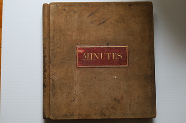
Administrative record (Collection) - Grasmere cheese and Butter Factory Company Records, Grasmere Cheese and Butter Factory administrative employees, Records: Grasmere Cheese and Butter Factory, 1890-1959
Administrative Records of Grasmere Cheese and Butter Factory - source of collection unknown This collection of administrative records has been created for historical reasons and archival purposes.Items kept in two A2 size archival boxes in the Archives Room and stored in this way some years after the acquisition of these items at an unknown date.Four ledgers containing Minutes, two unbound packets of Minutes and one photographic supplement from a magazinegrasmere cheese and butter factory pty ltd, dairying in the warrnambool districtgrasmere cheese and butter factory pty ltd, dairying in the warrnambool district -
 The Beechworth Burke Museum
Photograph - Stereoscopic Photograph, c1900
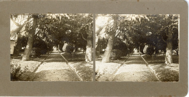
The gardens of Ovens District Hospital were laid out and planted by R H Jenkyns in 1874. Over 200 species of trees and shrubs were planted, including several large Himalayan Cedars (Cedrus deodora), a Coast Redwood (Sequoia sempervirens), rare Scots Pine (Pinus sylvestris), Pencil Cedar (Juniperus virginiana), Bunya Bunya Pines (Araucaria bidwillii), a Purple-leaved Dutch Elm (Ulmus x hollandica 'Purpurascens'), American Ash (Fraxinus americana), Pinus radiata, and numerous Populus alba trees and suckers. The gardens were considered integral to the healing process, also including orchards and kitchen gardens. In the 1880s, tourists flocked to Beechworth as the area became recognised as a health resort and picturesque beauty spot. Although the hospital closed in 1940, and parts were subsequently demolished, the gardens remain and form part of the site's listing on the Victorian Heritage Register. This photograph is part of a collection of items held by the Burke Museum relating to Ovens District Hospital. At the time of being built, the Ovens District Hospital was the only hospital between Melbourne, Victoria, and Goulburn, New South Wales, treating patients from all of north-east Victoria, including Indigo Shire.Black and white stereoscopic photograph mounted on card.Reverse: 97-2292 / View up centre path of Hospital / A03177 / BMM3177 / Note: A03178 / View of the central path of the Ovens Hospital / (Church St) Beechworthovens hospital, hospital garden, gardens and parks, ovens district hospital -
 8th/13th Victorian Mounted Rifles Regimental Collection
Photograph - watering horses
See also 3089.86. Information with that photo gives an alternative provenance: 8th Light Horse Regiment watering horses at a Murray River lagoon, South Corowa NSW, September 1939; Wahgunyah Troop, C Squadron - this side of lagoon, Lieutenant J. Nott on grey horse in water. The number of horsemen would seem to exceed that of a single regiment so the Torquay description would seem more probable.Black and white photograph ( laminated ) of 8th, 13th,20th, and 4thLight Horse Regiments watering horses near Torquay Victoria , March 1940.Picture taken about March 1940 when the 13th Light Horse from Gippsland, the 8th Light Horse from Upper Murray, the 4th Light Horse from the Western Districts and the 20th Light Horse from the Goulburn Valley were in camp near Torquay. Mr Cappur Webb of Glendoxey, Seymour, a member of the 20th said the picture must have been taken during an exercise about five miles north of Torquay. “We used to water our horses in that lake”, he said." light horse, torquay, wwii, world war two, military, horses