Showing 1527 items matching "high street road"
-
 Kew Historical Society Inc
Slide - Kew Post Office, 1980
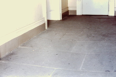
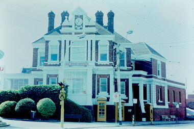
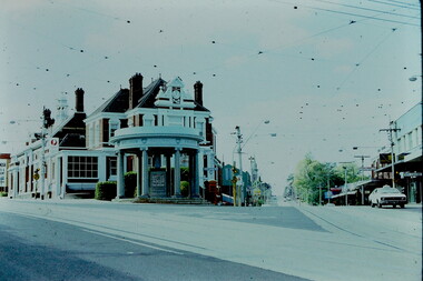
... of the Kew Post Office at the corner of High Street and Cotham Road... at the corner of High Street and Cotham Road. The building ...A civic campaign for new public offices developed in Kew in the 1880s. After much deliberation, the location chosen was the junction of Bulleen and Cotham Roads. The buildings were designed by George Watson and John Henry Harvey, architects within the Department of Public Works (Victoria). Building was commenced in 1887, and after one year, the buildings were opened. The Post Office was transferred to the new Commonwealth Government in 1901. The Police Station and Court House, sold by the Victorian Government to the City of Boroondara in 2007, are now a community cultural centre and performing arts venue.The buildings were listed on the Victorian Heritage Register Register (HO885) in 1991. They are historically and architecturally significant to the State Of Victoria because Watson and Harvey's designs exhibit diversity in integrating civil offices, they accommodate the apex of road junctions, and they demonstrate a departure from the contemporaneously favoured High Victorian Classical to the Queen Anne style in the design of civic buildings. 35mm colour transparency of an architectural feature of the Kew Post Office at the corner of High Street and Cotham Road. The building is a significant example of the English Queen Anne Revival style. The photographs were taken by John Coghlan in May 1980 while it was still a functioning post office to support his written report: ‘The functional planning design, building materials and construction methods of the Kew Post Office.’ kew post office, khs - slides, new public offices -- kew (vic.), architectural styles -- english queen anne revival -
 Kew Historical Society Inc
Slide - Kew Post Office, 1980
... of the Kew Post Office at the corner of High Street and Cotham Road... at the corner of High Street and Cotham Road. The building ...A civic campaign for new public offices developed in Kew in the 1880s. After much deliberation, the location chosen was the junction of Bulleen and Cotham Roads. The buildings were designed by George Watson and John Henry Harvey, architects within the Department of Public Works (Victoria). Building was commenced in 1887, and after one year, the buildings were opened. The Post Office was transferred to the new Commonwealth Government in 1901. The Police Station and Court House, sold by the Victorian Government to the City of Boroondara in 2007, are now a community cultural centre and performing arts venue.The buildings were listed on the Victorian Heritage Register Register (HO885) in 1991. They are historically and architecturally significant to the State of Victoria because Watson and Harvey's designs exhibit diversity in integrating civil offices, they accommodate the apex of road junctions, and they demonstrate a departure from the contemporaneously favoured High Victorian Classical to the Queen Anne style in the design of civic buildings. 35mm colour transparency of an architectural feature of the Kew Post Office at the corner of High Street and Cotham Road. The building is a significant example of the English Queen Anne Revival style. The photographs were taken by John Coghlan in May 1980 while it was still a functioning post office to support his written report: ‘The functional planning design, building materials and construction methods of the Kew Post Office.’ kew post office, khs - slides, new public offices -- kew (vic.), architectural styles -- english queen anne revival -
 Kew Historical Society Inc
Slide - Kew Post Office, 1980
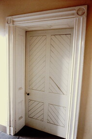
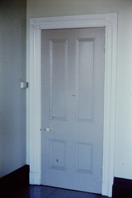
... at the corner of High Street and Cotham Road. The building... Street and Cotham Road. The building is a significant example ...A civic campaign for new public offices developed in Kew in the 1880s. After much deliberation, the location chosen was the junction of Bulleen and Cotham Roads. The buildings were designed by George Watson and John Henry Harvey, architects within the Department of Public Works (Victoria). Building was commenced in 1887, and after one year, the buildings were opened. The Post Office was transferred to the new Commonwealth Government in 1901. The Police Station and Court House, sold by the Victorian Government to the City of Boroondara in 2007, are now a community cultural centre and performing arts venue.The buildings were listed on the Victorian Heritage Register Register (HO885) in 1991. They are historically and architecturally significant to the State of Victoria because Watson and Harvey's designs exhibit diversity in integrating civil offices, they accommodate the apex of road junctions, and they demonstrate a departure from the contemporaneously favoured High Victorian Classical to the Queen Anne style in the design of civic buildings. 35mm colour transparency of a door in the Kew Post Office at the corner of High Street and Cotham Road. The building is a significant example of the English Queen Anne Revival style. The photographs were taken by John Coghlan in May 1980 while it was still a functioning post office to support his written report: ‘The functional planning design, building materials and construction methods of the Kew Post Office.’ kew post office, khs - slides, new public offices -- kew (vic.), architectural styles -- english queen anne revival -
 Kew Historical Society Inc
Slide - Kew Post Office, 1980
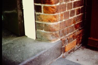
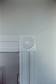
... Office at the corner of High Street and Cotham Road. The building... of High Street and Cotham Road. The building is a significant ...A civic campaign for new public offices developed in Kew in the 1880s. After much deliberation, the location chosen was the junction of Bulleen and Cotham Roads. The buildings were designed by George Watson and John Henry Harvey, architects within the Department of Public Works (Victoria). Building was commenced in 1887, and after one year, the buildings were opened. The Post Office was transferred to the new Commonwealth Government in 1901. The Police Station and Court House, sold by the Victorian Government to the City of Boroondara in 2007, are now a community cultural centre and performing arts venue.The buildings were listed on the Victorian Heritage Register Register (HO885) in 1991. They are historically and architecturally significant to the State of Victoria because Watson and Harvey's designs exhibit diversity in integrating civil offices, they accommodate the apex of road junctions, and they demonstrate a departure from the contemporaneously favoured High Victorian Classical to the Queen Anne style in the design of civic buildings. 35mm colour transparency of a door surround in the Kew Post Office at the corner of High Street and Cotham Road. The building is a significant example of the English Queen Anne Revival style. The photographs were taken by John Coghlan in May 1980 while it was still a functioning post office to support his written report: ‘The functional planning design, building materials and construction methods of the Kew Post Office.’ kew post office, khs - slides, new public offices -- kew (vic.), architectural styles -- english queen anne revival -
 Kew Historical Society Inc
Slide - Kew Post Office, 1980
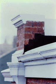
... Office at the corner of High Street and Cotham Road. The building... of High Street and Cotham Road. The building is a significant ...A civic campaign for new public offices developed in Kew in the 1880s. After much deliberation, the location chosen was the junction of Bulleen and Cotham Roads. The buildings were designed by George Watson and John Henry Harvey, architects within the Department of Public Works (Victoria). Building was commenced in 1887, and after one year, the buildings were opened. The Post Office was transferred to the new Commonwealth Government in 1901. The Police Station and Court House, sold by the Victorian Government to the City of Boroondara in 2007, are now a community cultural centre and performing arts venue.The buildings were listed on the Victorian Heritage Register Register (HO885) in 1991. They are historically and architecturally significant to the State of Victoria because Watson and Harvey's designs exhibit diversity in integrating civil offices, they accommodate the apex of road junctions, and they demonstrate a departure from the contemporaneously favoured High Victorian Classical to the Queen Anne style in the design of civic buildings. 35mm colour transparency of a mantelpiece in the Kew Post Office at the corner of High Street and Cotham Road. The building is a significant example of the English Queen Anne Revival style. The photographs were taken by John Coghlan in May 1980 while it was still a functioning post office to support his written report: ‘The functional planning design, building materials and construction methods of the Kew Post Office.’ kew post office, khs - slides, new public offices -- kew (vic.), architectural styles -- english queen anne revival -
 Kew Historical Society Inc
Photograph - Kew Junction, Herald & Weekly Times, 1962
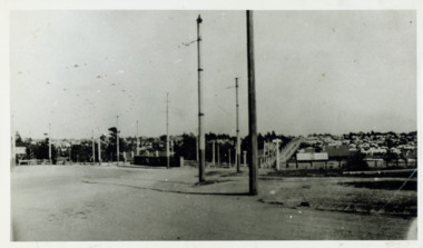
... the intersection of High Street South, Studley Park Road, Princess Street... for the blind kew municipal offices high street kew studley park road ...This is an aerial oblique image looking north. It shows Kew Junction before construction of VicRoads (Country Roads Board), Murphy's (Leo's) supermarket, and office towers. It also shows a building on the land now known as the Raoul Wallenberg Reserve, the Kew Municipal Offices in Walpole Street, and St Paul's School for the Blind in Fernhurst Grove, and Kew Bowling Club in Wellington Street.An aerial photograph of Kew Junction, showing the intersection of High Street South, Studley Park Road, Princess Street, High Street and Denmark Street. A number of buildings, now demolished can be identified in the photo, including Jellis’ Bakeries on the corner of Princess Street and Studley Park Road." Annotation on reverse: "Kew Historical Society from Mr L. H. Chinner".kew junction, aerial photograph (kew), oblique aerial, st paul's school for the blind, kew municipal offices, high street kew, studley park road, kew war memorial, kew post office, kew police station, kew court house, high street south, kew, wellington street kew, denmark street kew -
 Kew Historical Society Inc
Slide - Kew Post Office, 1980
... Office on the corner of High Street and Cotham Road. The [former... Street and Cotham Road. The [former] post office is a significant ...A civic campaign for new public offices developed in Kew in the 1880s. After much deliberation, the location chosen was the junction of Bulleen and Cotham Roads. The buildings were designed by George Watson and John Henry Harvey, architects within the Department of Public Works (Victoria). Building was commenced in 1887, and after one year, the buildings were opened. The Post Office was transferred to the new Commonwealth Government in 1901. The Police Station and Court House, sold by the Victorian Government to the City of Boroondara in 2007, are now a community cultural centre and performing arts venue.The buildings were listed on the Victorian Heritage Register Register (HO885) in 1991. They are historically and architecturally significant to the State of Victoria because Watson and Harvey's designs exhibit diversity in integrating civil offices, they accommodate the apex of road junctions, and they demonstrate a departure from the contemporaneously favoured High Victorian Classical to the Queen Anne style in the design of civic buildings. 35mm colour transparency of the facade of the Kew Post Office on the corner of High Street and Cotham Road. The [former] post office is a significant example of the English Queen Anne Revival style. The photograph was taken as part of a series by Ralph Andrews (Department of Building, RMIT) in April 1980. The colour of the slide has degraded over time but is still valuable as a record of the architectural treatment of the building and accompanying planting in the 1970s. kew post office, khs - slides, new public offices -- kew (vic.), architectural styles -- english queen anne revival -
 Kew Historical Society Inc
Slide - Kew Post Office, 1980
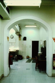
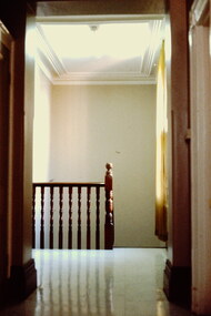
... in the Kew Post Office at the corner of High Street and Cotham Road... at the corner of High Street and Cotham Road. The building ...A civic campaign for new public offices developed in Kew in the 1880s. After much deliberation, the location chosen was the junction of Bulleen and Cotham Roads. The buildings were designed by George Watson and John Henry Harvey, architects within the Department of Public Works (Victoria). Building was commenced in 1887, and after one year, the buildings were opened. The Post Office was transferred to the new Commonwealth Government in 1901. The Police Station and Court House, sold by the Victorian Government to the City of Boroondara in 2007, are now a community cultural centre and performing arts venue.The buildings were listed on the Victorian Heritage Register Register (HO885) in 1991. They are historically and architecturally significant to the State of Victoria because Watson and Harvey's designs exhibit diversity in integrating civil offices, they accommodate the apex of road junctions, and they demonstrate a departure from the contemporaneously favoured High Victorian Classical to the Queen Anne style in the design of civic buildings. 35mm colour transparency of the first floor landing in the Kew Post Office at the corner of High Street and Cotham Road. The building is a significant example of the English Queen Anne Revival style. The photographs were taken by John Coghlan in May 1980 while it was still a functioning post office to support his written report: ‘The functional planning design, building materials and construction methods of the Kew Post Office.’ kew post office, khs - slides, new public offices -- kew (vic.), architectural styles -- english queen anne revival -
 Kew Historical Society Inc
Slide - Kew Post Office, 1980
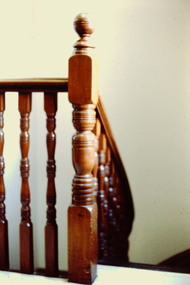
... and staircase in the Kew Post Office at the corner of High Street... Office at the corner of High Street and Cotham Road. The building ...A civic campaign for new public offices developed in Kew in the 1880s. After much deliberation, the location chosen was the junction of Bulleen and Cotham Roads. The buildings were designed by George Watson and John Henry Harvey, architects within the Department of Public Works (Victoria). Building was commenced in 1887, and after one year, the buildings were opened. The Post Office was transferred to the new Commonwealth Government in 1901. The Police Station and Court House, sold by the Victorian Government to the City of Boroondara in 2007, are now a community cultural centre and performing arts venue.The buildings were listed on the Victorian Heritage Register Register (HO885) in 1991. They are historically and architecturally significant to the State of Victoria because Watson and Harvey's designs exhibit diversity in integrating civil offices, they accommodate the apex of road junctions, and they demonstrate a departure from the contemporaneously favoured High Victorian Classical to the Queen Anne style in the design of civic buildings. 35mm colour transparency of the first floor landing and staircase in the Kew Post Office at the corner of High Street and Cotham Road. The building is a significant example of the English Queen Anne Revival style. The photographs were taken by John Coghlan in May 1980 while it was still a functioning post office to support his written report: ‘The functional planning design, building materials and construction methods of the Kew Post Office.’ kew post office, khs - slides, new public offices -- kew (vic.), architectural styles -- english queen anne revival -
 Kew Historical Society Inc
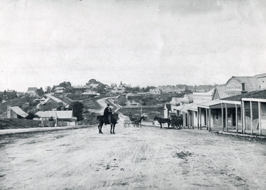
Photograph - Looking towards Kew from Strathalbyn Street and High Street, c.1916
... High Street, Kew (formerly Bulleen Road). In the centre... An electrified tram route from Melbourne along High Street replaced ...An electrified tram route from Melbourne along High Street replaced an original Horse Tram that terminated at the Kew Cemetery. This new tram only reached the bridge over the Outer Circle railway at the Harp Junction. The line was later extended to North Balwyn.Black and white print positive showing the view west along High Street, Kew (formerly Bulleen Road). In the centre distance is the Boroondara General (Kew) Cemetery. In the foreground, the road crosses the Outer Circle railway. The photograph reflects the level of urbanisation in Kew during the First World War. "Looking towards Kew from Strathalbyn St / High St corner, about 1916. Courtesy Mrs E Bennett, Kew East / Property of Miss Foley"trams -- kew, trams -- kew east, mmtb, m&mtb, tramways, harp junction -
 Kew Historical Society Inc
Plan - Subdivision Plan, Flower Farm Estate, East Kew, 1922
... Road between High Street and Harp Road. In an advertisement... on either side of Boorool Road between High Street and Harp Road ...Pru Sanderson, in her groundbreaking ‘City of Kew Urban Conservation Study : Volume 2 - Development History’ (1988), summarised the periods of urban development and subdivisions of land in Kew. The periods that she identified included 1845-1880, 1880-1893, 1893-1921, 1921-1933, 1933-1943, and Post-War Development. These periods were selected as they represented periods of rapid growth or decline in urban development. An obvious starting point for Sanderson’s groupings involved population growth and the associated economic cycles. These cycles also highlighted urban expansion onto land that was predominantly rural, although in other cases it represented the decline and breakup of large estates. A number of the plans in the Kew Historical Society’s collection can also be found in other collections, such as those of the State Library of Victoria and the Boroondara Library Service. A number are however unique to the collection.The Kew Historical Society collection includes almost 100 subdivision plans pertaining to suburbs of the City of Melbourne. Most of these are of Kew, Kew East or Studley Park, although a smaller number are plans of Camberwell, Deepdene, Balwyn and Hawthorn. It is believed that the majority of the plans were gifted to the Society by persons connected with the real estate firm - J. R. Mathers and McMillan, 136 Cotham Road, Kew. The Plans in the collection are rarely in pristine form, being working plans on which the agent would write notes and record lots sold and the prices of these. The subdivision plans are historically significant examples of the growth of urban Melbourne from the beginning of the 20th Century up until the 1980s. A number of the plans are double-sided and often include a photograph on the reverse. The subdivision called the ‘Flower Farm Estate’ in Kew East occurred in 1922. It included 61 lots on either side of Boorool Road between High Street and Harp Road. In an advertisement in The Argus in the same year, the proximity of the estate to the newly erected shops at the corner of Harp Road and High Street is noted. The Flower Farm Estate and similar subdivisions in Kew East were assisted by the extension of the High Street tramline in 1924.subdivision plans - east kew, flower farm estate, high street - kew east (vic.), boorool road -- kew east (vic.), harp road -- kew east (vic.) -
 Kew Historical Society Inc
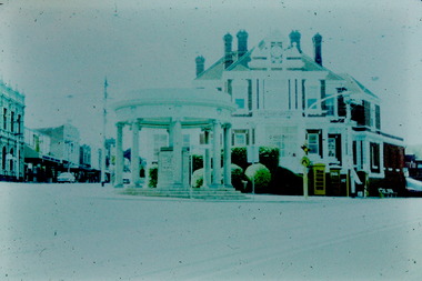
Slide - Kew Post Office and War Memorial, 1980
... Memorial on the corner of High Street and Cotham Road. The [former... of High Street and Cotham Road. The [former] post office ...A civic campaign for new public offices developed in Kew in the 1880s. After much deliberation, the location chosen was the junction of Bulleen and Cotham Roads. The buildings were designed by George Watson and John Henry Harvey, architects within the Department of Public Works (Victoria). Building was commenced in 1887, and after one year, the buildings were opened. The Post Office was transferred to the new Commonwealth Government in 1901. The Police Station and Court House, sold by the Victorian Government to the City of Boroondara in 2007, are now a community cultural centre and performing arts venue.The buildings were listed on the Victorian Heritage Register Register (HO885) in 1991. They are historically and architecturally significant to the State of Victoria because Watson and Harvey's designs exhibit diversity in integrating civil offices, they accommodate the apex of road junctions, and they demonstrate a departure from the contemporaneously favoured High Victorian Classical to the Queen Anne style in the design of civic buildings. 35mm colour transparency of the Kew Post Office and Kew War Memorial on the corner of High Street and Cotham Road. The [former] post office is a significant example of the English Queen Anne Revival style. The photograph was taken as part of a series by Ralph Andrews (Department of Building, RMIT) in April 1980. The colour of the slide has degraded over time but is still valuable as a record of the architectural treatment of the building and accompanying planting in the 1970s. kew post office, khs - slides, new public offices -- kew (vic.), architectural styles -- english queen anne revival -
 Kew Historical Society Inc
Slide - Kew Post Office and War Memorial, 1980
... Memorial on the corner of High Street and Cotham Road. The [former... of High Street and Cotham Road. The [former] post office ...A civic campaign for new public offices developed in Kew in the 1880s. After much deliberation, the location chosen was the junction of Bulleen and Cotham Roads. The buildings were designed by George Watson and John Henry Harvey, architects within the Department of Public Works (Victoria). Building was commenced in 1887, and after one year, the buildings were opened. The Post Office was transferred to the new Commonwealth Government in 1901. The Police Station and Court House, sold by the Victorian Government to the City of Boroondara in 2007, are now a community cultural centre and performing arts venue.The buildings were listed on the Victorian Heritage Register Register (HO885) in 1991. They are historically and architecturally significant to the State of Victoria because Watson and Harvey's designs exhibit diversity in integrating civil offices, they accommodate the apex of road junctions, and they demonstrate a departure from the contemporaneously favoured High Victorian Classical to the Queen Anne style in the design of civic buildings. 35mm colour transparency of the Kew Post Office and Kew War Memorial on the corner of High Street and Cotham Road. The [former] post office is a significant example of the English Queen Anne Revival style. The photograph was taken as part of a series by Ralph Andrews (Department of Building, RMIT) in April 1980. The colour of the slide has degraded over time but is still valuable as a record of the architectural treatment of the building and accompanying planting in the 1970s. kew post office, khs - slides, new public offices -- kew (vic.), architectural styles -- english queen anne revival, wwi -
 Kew Historical Society Inc
Archive (Sub-series) - Subject File, Conservation Study (Kew) 1978, 1978
... Street, High Street South and Barkers Road, then known... in Denmark Street, High Street South and Barkers Road, then known ...Various partiesReference, Research, InformationSecondary Values (KHS Imposed Order)Subject file containing a copy of the City of Kew’s Urban Renewal Proposal (13pp), dated June 1978. The proposal to the Urban Renewal Authority relates to those houses in Denmark Street, High Street South and Barkers Road, then known as ‘The Triangle’ (historically known as O’Shaughnessy’s Paddock. The report refers to the Kew Triangle Association.urban renewal -- kew (vic.), conservation studies -- kew (vic.), kew triangle associationurban renewal -- kew (vic.), conservation studies -- kew (vic.), kew triangle association -
 Kew Historical Society Inc
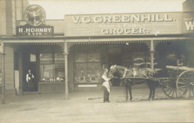
Postcard - V.G. Greenhill's Grocery Store, High Street (Kew), c.1902
... Store were located at 43 1/2 and 45 High Street (formerly... located at 43 1/2 and 45 High Street (formerly Bulleen Road ...R.H. Hornby & Sons, jewellers, and V. Greenhill's Grocery Store were located at 43 1/2 and 45 High Street (formerly Bulleen Road) respectively, in the block of shops between Brougham Street and Walpole Street. The grocery first appears at this location in 1893 but only in 1902 is the jeweller's shop located next door. (Sands & McDougall Directories). The Greenhill family were significant pioneers of Kew in the nineteenth century and their members participated in many civic, community and sporting organisations.Original sepia, real photo postcard of two shops in High Street, Kew, circa 1902. The businesses were R. Hornby, jewellers and opticians, and V.G. Greenhill, grocer. The proprietor of the jeweller's shop stands in his doorway while a member of staff of Greenhill's is standing on the road with a horse and cart owned by the business. The signage on the grocery shop identifies the kind of business offered - Choice fruits & confectionery / Dairy Produce a specialty. On the windows from left to right are advertisements for Fry's Chocolate, Fry's Pure Cocoa, and Cadbury's Cocoa and Cadbury's Chocolate. Above the doorway is a pane of etched glass reading GREENHILL 45.Unmarked postcard layout on reversev greenhill, grocery stores -- kew (vic.), jewellers -- kew (vic), high street -- kew (vic.), businesses -- kew (vic), hornby family, greenhill family -
 Bendigo Historical Society Inc.
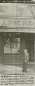
Newspaper - JENNY FOLET COLLECTION: WATCH AND CLOCK
... were on the High Street and Sailors Gully Road junction... and colonial jewellery to order. The premises were on the High Street ...Bendigo Advertiser ''The way we were'' from 2000. Watch and clock: James Pickens established his business prior to 1872. In 1901 he was listed as ''watch and clock'' maker. He made and repaired English and colonial jewellery to order. The premises were on the High Street and Sailors Gully Road junction. The clip is in a folder.newspaper, bendigo advertiser, the way we were -
 Bendigo Historical Society Inc.
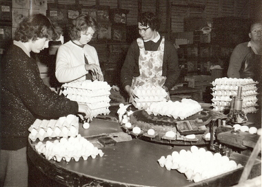
Photograph - SYMPAG, c1961
... at Sympag, corner of High Street and Lockwood Road Kangaroo Flat... of High Street and Lockwood Road Kangaroo Flat for the Victorian ...Black and white photograph: Grading and packing eggs at Sympag, corner of High Street and Lockwood Road Kangaroo Flat for the Victorian egg board. The name Sympag is derived from two surnames believed to be from Mr Sym and Mrs Agg. Inscriptions Markings: Trading at Sympag Egg Flour Floor 1961. Elaine Rotheberger, Mrs Val Tarr in apron. Stamped on rear of photograph COPYRIGHT NOT FOR REPORODUCTION. HERALD - SUN PHOTOGRAPH SUPPLIED BY FEATURE SERVICE THE HERALD & WEEKLY TIMES LTD. MELBOURNE AUSTRALIAHerald & Weekly Times Ltd. Melbourneorganization, business, sympag, copyright not for reproduction, herald sun photograph, supplied by feature service, the herald & weekly times ltd. melbourne australia -
 Kew Historical Society Inc
Photograph - William John Lamb : Station Master, East Kew Railway Station
... end of Harp Road, Kew, near the junction of High Street... end of Harp Road, Kew, near the junction of High Street ...William John Lamb (1878-1958) was born in Ballarat, the second oldest of eight children. His father was born in Scotland and had later migrated to Australia. William Lamb lived in Bright Street, Kew, with his daughter. This was possibly his family home. He died in 1958 aged 80. The Outer Circle Railway on which he worked as station master at East Kew connected the Oakleigh and Fairfield Park Stations. The East Kew Station was on the northern end of Harp Road, Kew, near the junction of High Street and Harp Road.outer circle railway, east kew railway station, station masters - outer circle railway -
 Kew Historical Society Inc
Plan, Melbourne & Metropolitan Board of Works : Borough of Kew : Detail Plan No.1590, 1905
... includes built structures in Mary Street, Cotham Road, High Street... includes built structures in Mary Street, Cotham Road, High Street ...The Melbourne and Metropolitan Board of Works (MMBW) plans were produced from the 1890s to the 1950s. They were crucial to the design and development of Melbourne's sewerage and drainage system. The plans, at a scale of 40 feet to 1 inch (1:480), provide a detailed historical record of Melbourne streetscapes and environmental features. Each plan covers one or two street blocks (roughly six streets), showing details of buildings, including garden layouts and ownership boundaries, and features such as laneways, drains, bridges, parks, municipal boundaries and other prominent landmarks as they existed at the time each plan was produced. (Source: State Library of Victoria)This plan forms part of a large group of MMBW plans and maps that was donated to the Society by the Mr Poulter, City Engineer of the City of Kew in 1989. Within this collection, thirty-five hand-coloured plans, backed with linen, are of statewide significance as they include annotations that provide details of construction materials used in buildings in the first decade of the 20th century as well as additional information about land ownership and usage. The copies in the Public Record Office Victoria and the State Library of Victoria are monochrome versions which do not denote building materials so that the maps in this collection are invaluable and unique tools for researchers and heritage consultants. A number of the plans are not held in the collection of the State Library of Victoria so they have the additional attribute of rarity.Original survey plan, issued by the MMBW to a contractor with responsibility for constructing sewers in the area identified on the plan within the Borough of Kew. The plan was at some stage hand-coloured, possibly by the contractor, but more likely by officers working in the Engineering Department of the Borough and later Town, then City of Kew. The hand-coloured sections of buildings on the plan were used to denote masonry or brick constructions (pink), weatherboard constructions (yellow), and public buildings (grey). Surveyed by the Board of Works in 1903 and published in 1904, Plan No.1590 shows development north of Cotham Road. While this plan includes built structures in Mary Street, Cotham Road, High Street, Park Hill Road, Kent Street, Ridgeway Avenue, and Ermington Lane (now Ermington Place), only part of this section was notated and coloured in this contractor’s copy. Numerous houses, large and small are named on the plan: ‘Cholula’, ‘Belper’, ‘The Uplands’, ‘Spring Grove’ facing Cotham Road; ‘Marion’ facing Kent Street; and ‘Kia Ora’ facing Ridgeway Avenue.melbourne and metropolitan board of works, detail plans, mmbw 1590, survey plans - borough of kew, cartography -
 Kew Historical Society Inc
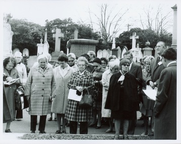
Photograph - Tour of the Boroondara (Kew) General Cemetery, 1977
... an unusual triangular reserve bounded by High Street, Park Hill Road... triangular reserve bounded by High Street, Park Hill Road ...Boroondara Cemetery, established in 1858, is within an unusual triangular reserve bounded by High Street, Park Hill Road and Victoria Park, Kew. By the 1890s, the Boroondara Cemetery was a popular destination for visitors and locals admiring the beauty of the grounds and the splendid monuments. The Boroondara Cemetery is of historical significance for the graves, monuments and epitaphs of a number of individuals whose activities have played a major part in Australia's history. They include the Henty family, artists Louis Buvelot and Charles Nuttall, businessmen John Halfey and publisher David Syme, artist and diarist Georgiana McCrae, actress Nellie Stewart and architect and designer of the Boroondara and Melbourne General Cemeteries, Albert Purchas.Walking tour led by Kew Historical Society members for members of the Royal Historical Society of Victoria in 1977. The photograph shows members of both parties assembled at a grave in the Cemetery. The photograph was one of six taken by KHS member Stewart West on that occasion, and subsequently donated by him to the collection by him.Reverse: "Front row in dark coat and glasses - Mrs Mills, With dark glasses reading - Mrs Ekberg (KHS member); Second from right Mr Slattery then president of Society; Far left Miss B Mackie (KHS member)" boroondara general cemetery, kew cemetery, walking tours -
 Kew Historical Society Inc
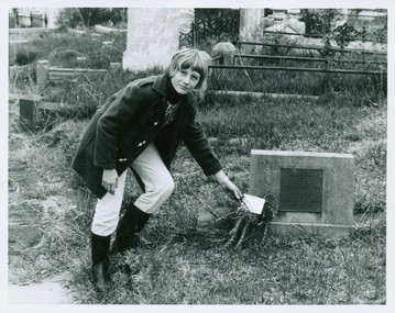
Photograph - Tour of the Boroondara (Kew) General Cemetery, 1977
... an unusual triangular reserve bounded by High Street, Park Hill Road... triangular reserve bounded by High Street, Park Hill Road ...Boroondara Cemetery, established in 1858, is within an unusual triangular reserve bounded by High Street, Park Hill Road and Victoria Park, Kew. By the 1890s, the Boroondara Cemetery was a popular destination for visitors and locals admiring the beauty of the grounds and the splendid monuments. The Boroondara Cemetery is of historical significance for the graves, monuments and epitaphs of a number of individuals whose activities have played a major part in Australia's history. They include the Henty family, artists Louis Buvelot and Charles Nuttall, businessmen John Halfey and publisher David Syme, artist and diarist Georgiana McCrae, actress Nellie Stewart and architect and designer of the Boroondara and Melbourne General Cemeteries, Albert Purchas.Walking tour led by Kew Historical Society members for members of the Royal Historical Society of Victoria in 1977. The photograph shows a Kew youth placing a sprig of Rosemary on Ellen Quick's grave. The photograph was one of six taken by KHS member Stewart West on that occasion, and subsequently donated by him to the collection by him.Reverse: "Kew youth placing a sprig of rosemary on grave of Ellen Quick nee Derrick who was the first burial on 12/3/1859. Her family Derricks were early Kew Landowners." boroondara general cemetery, kew cemetery, walking tours, ellen quick, dannock family, kew pioneers -
 Kew Historical Society Inc
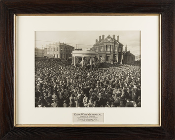
Photograph, The Sears Studio, Kew War Memorial: Ceremony of Unveiling by Sir Excellency the Governor Earl of Stradbroke KCMG, Sunday 30th August 1925
... of High Street and Cotham Road. The voices of the Governor... of High Street and Cotham Road. The voices of the Governor ...The original, very large framed photograph of the ceremony of Unveiling of the Kew War Memorial, by His Excellency the Governor, Earl of Stradbroke KCMG, Sunday 30 August 1925. At the ceremony there were over five thousand in attendance crowding the intersection of High Street and Cotham Road. The voices of the Governor and the Mayor, Councillor Jabez Carnegie were amplified from four loud speakers on the dome of the memorial. A guard of honour from the 39th Battalion C.M.F. was present, together with the First Kew Troop of Boy Scouts. Restoration of the work by staff at the Grimwade Centre has been made possible by a contribution from Andrew McIntosh M.L.A.Iconic Australian photograph from the post-WW1 period. Nationally significant work reflecting how societies of the time invested social and spiritual values in commemorations of wartime.Framed large photograph. Kew War Memorial : Ceremony of Unveiling by His Excellency the Governor Earl of Stradbroke KCMG, Sunday 30th August 1925. Image of framed photo taken after cleaning and restoration by Grimwade Conservation Services. Digitally cleaned image included in carousel.Kew War Memorial: Ceremony of Unveiling by Sir Excellency the Governor Earl of Stradbroke KCMG, Sunday 30th August 1925 / Sears Studiokew war memorial - 1925, civic collection, sears studio, kew town hall -
 Kew Historical Society Inc
Plan - Subdivision Plan, Oswinia Estate, East Kew, c.1925
... created in the triangular section of land bordered by High Street... plans - east kew oswinia estate high street, glass street, namur ...Prue Sanderson, in her groundbreaking ‘City of Kew Urban Conservation Study : Volume 2 - Development History’ (1988), summarised the periods of urban development and subdivisions of land in Kew. The periods that she identified included 1845-1880, 1880-1893, 1893-1921, 1921-1933, 1933-1943, and Post-War Development. These periods were selected as they represented periods of rapid growth or decline in urban development. An obvious starting point for Sanderson’s groupings involved population growth and the associated economic cycles. These cycles also highlighted urban expansion onto land that was predominantly rural, although in other cases it represented the decline and breakup of large estates. A number of the plans in the Kew Historical Society’s collection can also be found in other collections, such as those of the State Library of Victoria and the Boroondara Library Service. A number are however unique to the collection.Subdivision plans are historically important documents used as evidence of the growth of suburbs in Australia. They frequently provide information about when the land was sold on which a built structure was subsequently constructed as well as evidence relating to surveyors and real estate and financial agents. The numerous subdivision plans in the Kew Historical Society's collection represent working documents, ranging from the initial sketches made in planning a subdivision to printed plans on which auctioneers or agents listed the prices for which individual lots were sold. In a number of cases, the reverse of a subdivision plan in the collection includes a photograph of a house that was also for sale by the agent. These photographs provide significant heritage information relating house design and decoration, fencing and household gardens.The ‘Oswinia Estate’ subdivision in East Kew was planned and auctioned in the first half of the 1920s. 169 allotments were created in the triangular section of land bordered by High Street, Burke Road and the Government Boulevard (later Kilby Road). The only piece of land excluded was that where the previous Kew Pound had been located at the east tip of the triangle. Allotments were created fronting Glass, High, Namur, Oswin Streets, Irymple Avenue, and the Government Boulevard. The name for the Estate was derived from Oswin’s farm, which had been one of the largest landholdings in East Kew. The selling agents annotated the plan in our collection with crosses indicating those lots that had been sold. The inset locality plan is particularly interesting as it shows the route and stations of the Outer Circle Railway. When the subdivision plan was created, it included the proposed bridge over the Yarra at Burke Road. The bridge was to be officially opened in 1926.subdivision plans - east kew, oswinia estate, high street, glass street, namur street, government boulevard - kilby road, irymple street, oswin street -
 Wodonga & District Historical Society Inc
Photograph - Mann Collection Album - Melba Hall/old Shire Offices and Dr. Grant’s Surgery, C. 1960s - 1970
... located on the corner of High Street and Melbourne Road... located on the corner of High Street and Melbourne Road ...Elaine Mann was married to David Mann, a successful Wodonga businessman and community leader who passed away in Wodonga in June 2012. David was a member of the Mann family who began their business in Wodonga in 1920. Elaine was a teacher in Wodonga for many years and an active member of the community.This photo collection is of significance as it documents how the businesses and buildings in Wodonga have evolved and contributed to community throughout the late 20th century.Melba Hall/old Shire Offices and Dr. Grant’s Surgery located on the corner of High Street and Melbourne Road. The building was constructed in 1890. Dr. Grant Sr.'s Surgery was in the house on the left. These were Wodonga’s second shire offices. The Wodonga Council operated from these chambers from 1890 until 1957 when they moved to Woodland Grove building. The Gas Company then took over the old Shire Hall. The entrance to the Melba Theatre is on the far right. The Melba Theatre screened its last film in 1968. The building was demolished in 1971 to make way for a Safeway supermarket and car park.On front of the building above door "GAS SUPPLY/ CO."wodonga businesses, high st wodonga, dr. grant, melba hall -
 Kew Historical Society Inc
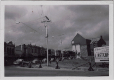
Photograph - Kew Junction during road widening, December 1958
... - Denmark Street, High Street, High Street South, Studley Park Road..., High Street, High Street South, Studley Park Road and Princess ...Kew Junction is the intersection of five major roads - Denmark Street, High Street, High Street South, Studley Park Road and Princess Street. The original widening of High Street in the 1930s expanded that street by removing shops on the south side of the street from Cotham Road to Denmark Street. Further widening in 1958 removed shops at the west end of High Street to allow for increased traffic using Princes Street and Denmark Street.Original, black and white positive of Kew Junction, including the corner with Denmark Street during road widening in the 1958.Inscribed verso: "Kew Junction Dec 1958 / When the road was being widened by the removal of a number of shops / Notice saying Retchford's Estate agency's temporary office is at the top end of Denmark Street, Kew"kew junction, denmark street -- kew (vic.), major roadworks -- kew (vic.) -
 The Beechworth Burke Museum
Photograph, c1900
... , Beechworth and across to Ford Street (left) and High Street (right...The Beechworth Burke Museum Loch Street Beechworth high ...Believed to have been taken sometime between 1858 and 1908, featuring a man with moustache, dressed in hat and long riding coat, seated on a bob-tailed horse, is stopped in the middle of a wide dirt road in Beechworth. He is outside a row of businesses, including R.McKenzie & Sons Grain Store and Mackenzie Family Store (Wholesale & Retail Est. 1855), along a sloping hill. Behind the main rider are a parked horse and laden two-wheeled cart backed up directly outside the grain store's verandah, and another man is driving a horse and four-wheeled wagon forward towards them. At the bottom of the hill is a bridge (Newtown Bridge) with forked road on the far side, leading to a number of houses on both sides of another hill. This image is looking down Bridge Street, Newtown, Beechworth and across to Ford Street (left) and High Street (right). Road-making was a focus of town development during the 1850s, and the wide streets were created on the instructions of the surveyor-general to be between sixty-six and ninety-nine feet wide to give the town a pleasing aspect.This photograph is important in showing the development and expansion of the various businesses and buildings in Bridge Street of Newtown, Beechworth. Black and white rectangular photograph printed on paperReverse: 6980/ PH 118/ 1998.00059/beechworth, new town, newtown, newtown beechworth, local business, mackenzie family store, mackenzie's family store, mackenzie, grain store, bridge, ford steet, high street, colonial australia, australian gold rushes, mining technology, beechworth historic district, indigo gold trail, migration, indigo shire, mckenzie and sons grainstore, mckenzie family store, mckenzie, newtown bridge