Showing 5053 items
matching housing development
-
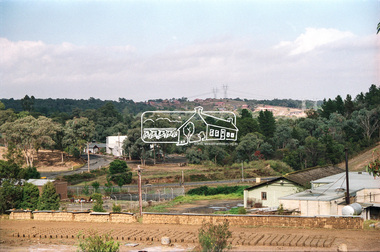 Eltham District Historical Society Inc
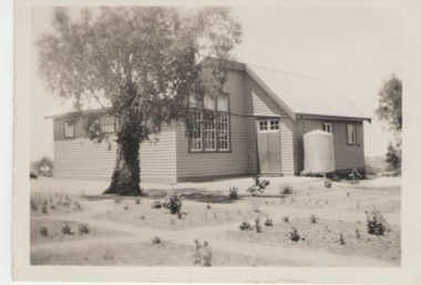
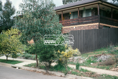
Negative - Photograph, View towards Main Road, Research from Maroondah Aqueduct Trail showing mudbrick manufacture, Research Industrial Estate, 1991
... Eltham Little Theatre in centre distance and new housing...Eltham Little Theatre in centre distance and new housing ...Eltham Little Theatre in centre distance and new housing estate development off Reynolds Road in distanceRoll of 35mm colour negative film, 9 strips Colour print 10 x 15 cmFuji HG 200 CA-1eltham little theatre, houses, main road, maroondah aqueduct, maroondah aqueduct trail, mudbrick, mudbrick construction, research (vic.), research industrial estate, reynolds road -
 Ballarat Tramway Museum
Newspaper, The Courier Ballarat, "Tram depot sale plans proceed", 17/03/1972 12:00:00 AM
... Ballarat depot for a community housing development comprising 16... the former SEC Ballarat depot for a community housing development ...Newspaper clipping from The Courier, Ballarat, dated Friday, 17/3/1972, titled "Tram depot sale plans proceed". Report on the proposals of the SEC, reported by the Manager of the Mid-Western branch of the SEC, Mr. Ivan Pellas to sell the former SEC Ballarat depot for a community housing development comprising 16 housing units, children's play and parking areas. Comments on the proposal were being sought. One of large group of newspaper cuttings from John Bainbridge, 7/4/02.ballarat tramways, depot, sale of land, housing -
City of Kingston
Photograph - Colour, 29 January 1993
... consists predominantly of newer housing developments and the tidal... consists predominantly of newer housing developments and the tidal ...Bonbeach, Carrum and Patterson Lakes are suburbs in the City of Kingston. Bonbeach and Carrum were holiday destinations in early 20th century and over time the housing has converted to permanent residential structures. In Patterson Lakes, the area consists predominantly of newer housing developments and the tidal canal system which is accessible to many dwellings joins Port Phillip Bay.Bonbeach, Carrum and Patterson Lakes were previously part of the extensive Carrum Carrum Swamp. The area was once a source of fish and eels for the Mayone-Bulluk clan of the Bunurong people. Over time the area was drained and this allowed farming at Carrum and Bonbeach, although the area was prone to flooding. In the early 1920s and 30s the land was converted to residential dwellings. In 1973 investigations commenced nearby to Bonbeach and Carrum into the development of a unique residential area comprising canals and waterways. It was originally proposed to be known as "Gladesville". Circa 1974, the area was rezoned from rural to residential and named Patterson Lakes. Development has been continuous since the 1970s with staged construction of the waterways, residential housing, and supporting infrastructure and facilities.Laminated colour aerial photograph of the Bonbeach, Carrum and Patterson Lakes region within City of Kingston. This 1993 image includes Bonbeach High School prior to demolition, Bonbeach Primary School and Patterson River Golf Club. Sections of Patterson Lakes are not yet developed, including Rhode and Staten Islands. Long Island Point appears to be a recent development with many spare blocks and new houses under construction. The Patterson River marina is prominent and the river mouth as it meets Port Phillip Bay. The Carrum railway station is visible.Black type on white adhesive sticker: No. 6661 Black type on white adhesive sticker: 26E/6661, 29/1/93, 4.25 pm Black type on white adhesive sticker 29-1-93 Yellow circular adhesive stickerbonbeach, carrum, patterson lakes, patterson river, carrum carrum swamp, canals and waterways -
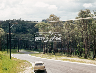 Eltham District Historical Society Inc
Photograph, Ancona Court, Eltham, 1 July 1972, 1972
... Housing estate development prior to houses being... melbourne Housing estate development prior to houses being ...Housing estate development prior to houses being constructed. New narrow road with roll over kerb treatment35mm colour positive transparency blue Agfacolour Service plastic mountancona court, eltham, infrastructure, streets -
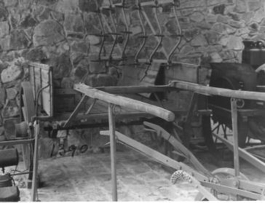 Whitehorse Historical Society Inc.
Vehicle - Spring Cart, C1930
... the orchard was sold for housing development.|In the 1840's a vehicle... the orchard was sold for housing development.|In the 1840's a vehicle ...This item was used as a general purpose cart on the Livermore Orchard in Vermont and was donated by Mr. Livermore when the orchard was sold for housing development.|In the 1840's a vehicle known as a springcart, chaise cart, and family cart was the choice of colonist who needed to travel from town to town. It was light, well sprung, capacious and adaptable. It was used by all stratas of society. See ref.Two wheeled general purpose spring cart, used on an orchard. Also known as a 'Jingle'. It is painted green and terracotta. It was pulled by one horse and has internal measurements of 0.46M x 1.5M x 2.46M.The wheels are 1.1M in diameter.rural industry, livestock, transport, horse -
Whitehorse Historical Society Inc.
Article, Brickworks Go-ahead, 2015
... Brickworks site in Burwood East for a housing & shopping centre... for a housing & shopping centre development by the developer Australand ...The State Government has re-zoned the former Burwood Brickworks site in Burwood East for a housing & shopping centre development by the developer Australand.The State Government has re-zoned the former Burwood Brickworks site in Burwood East for a housing & shopping centre development by the developer Australand.The State Government has re-zoned the former Burwood Brickworks site in Burwood East for a housing & shopping centre development by the developer Australand.brickworks, australand, middleborough road, burwood east -
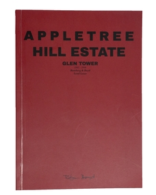 Robin Boyd Foundation
Booklet, Appletree Hill Estate (facsimile), 1965-66
... Housing Development, Glen Tower Drive, Glen Waverley, 1966... Housing Development, Glen Tower Drive, Glen Waverley, 1966 ...This is a facsimile copy, produced by Masters of Architecture Students at the Melbourne School of Design University of Melbourne, 2017. This feature correspondence, newspaper articles, and other material concerning the development of Appletree Hill Housing Development, Glen Tower Drive, Glen Waverley, 1966. In 1965 Lend Lease Homes commissioned Robin Boyd to design six brick veneer houses. They were built as a display village at Appletree Hill.A facsimile of an booklet to advertise Lend Lease homes designed by Robin Boyd.appletree estate, architecture, domestic architecture, housing estate, walsh st library -
 Sunbury Family History and Heritage Society Inc.
Photograph, Greenvale State School, 27 June 1934
... was relocated to a new building closer to the new housing development... was relocated to a new building closer to the new housing development ...The building is the former Greenvale State School No. 890. Although a school had been functioning at Greenvale since 1870. This is a photo of the school building that was renovated in 1926. At weekends the building was often used for family gatherings and social functions in the district. As the area became developed and changed from a country settlement to a suburb, the school was relocated to a new building closer to the new housing development. The existing building became a community centre. Many country settlements throughout Australia had similar school buildings which as well as being used for education also doubled up as venues for local social functioons.A non-digital sepia photograph with a surrounding white border of a two roomed country school with a water tank against a wall. A gum tree is growing in front of the building.schools -
City of Kingston
Photograph - Colour, 1993
... housing developments.... housing developments. Carrum is located in the area ...Carrum is a suburb in the City of Kingston bordered by the Patterson River in the north and Kananook Creek in the south. To the east the suburb is adjacent to Patterson Lakes. The Carrum Station was opened in 1882, when the railway line from Mordialloc was extended to Frankston. In the early 20th century, it was a destination for holidaymakers occupying tents and cabins. The area now consists of older housing and over time there have been many new housing developments.Carrum is located in the area that was originally part of the Carrum Carrum Swamp. The district had originally been the home of the Bunerong people who fished, gathered food and found refuge in the sand dunes. The Swamp was drained in 1879 when the Patterson Cut was formed and became known as Patterson River. Apart from local farmers, fishermen and hotel-keepers, there were few permanent residents until the early 20th century when it had become popular as a beach resort. In the 1920s and 1930s the area became occupied by more permanent residents.Laminated aerial colour photograph of Carrum and Patterson Lakes in the City of Kingston. The photograph also includes Kananook Creek and the northern section of Seaford. Prominent features include Roy Dore Reserve, Carrum Primary School, Patterson River Secondary College, Keast Park Seaford, the Seaford Swamp Drain and a section of Downs Estate situated on the traditional lands of the Bunurong people.Black type on white adhesive sticker: No. 7140 Black type of white adhesive sticker: 31-1-93 Black handwritten ink (marker): * [an asterisk] Yellow circular adhesive stickerpatterson lakes, seaford, carrum carrum swamp -
 Broadmeadows Historical Society & Museum
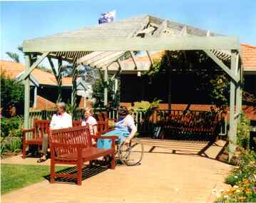
Photograph, Meeting under the Pergola to Chat, Banksia Gardens, 1998, 3 February 1998
... of life in the housing development during that period.... of life in the housing development during that period ..."Meeting Under the Pergola to Chat" is part of the Banksia Gardens collection from 1998. It captures a moment of social interaction within a public space designed for residents of social housing to meet and engage with their neighbours. This image highlights the significance of communal areas in fostering a sense of community and belonging among residents. The pergola serves as a focal point for social gatherings, reflecting the thoughtful urban planning aimed at enhancing social cohesion and quality of life in the housing development during that period.The photograph titled "Meeting Under the Pergola to Chat" is part of the Banksia Gardens collection from 1998. It depicts social housing with public spaces designed for neighbours to meet and interact. This image captures the essence of community life and the importance of shared spaces in fostering social connections within the housing development. The photograph not only documents the architectural and social planning of the era but also highlights the value placed on communal areas for enhancing the quality of life for residents.Colour photograph on glossy photographic paper."Pergola where neighbours meet to chat, Public Housing"/"Banksia Gardens 1998"social housing, banksia gardens, pergola, meeting place, 1998 -
 Warrnambool and District Historical Society Inc.
Booklet, Allansford Progress Association, Second half of 20th century
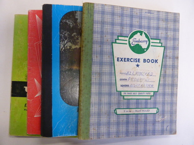
... the development of the Speedway, housing development, road proposals... of the Speedway, housing development, road proposals, waste management ...These four exercise books give documentation on the activities of the Allansford Progress Association (1966 to 1988). Allansford is a settlement about 9 kilometres from Warrnambool and most of the town area is now within the boundaries of the Warrnambool City Council. The association was re-formed in November 1966 after the demise of an earlier group. The members of the group campaigned in areas of local concern – T. V. reception, drainage and sewerage, postal services, sports facilities including the development of the Speedway, housing development, road proposals, waste management and disaster plans. These books are of interest in that they provide an overview of the history of a local organization. They will be useful for research. These are four exercise books - three Minutes books, and one Accounts book, from the Allansford Progress Association (1966-1988). The exercise books have coloured covers, (blue and white checkered, green, red and blue). Two are bound with tape and two are stapled. There are some loose sheets in all of the books. All the entries are handwritten. On front covers: ‘Allansford Progress Association’allansford progress association, history of allansford, history of warrnambool -
 Friends of Westgarthtown
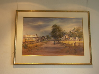
Painting, John Borrack, Ziebells, German Lane, South View
... for housing development. Buildings shown are cowshed, hay barn, engine... for housing development. Buildings shown are cowshed, hay barn, engine ...Painted from Gardenia Road. The extensive farm complex on the right. (Western side of Gardenia Road). was demolished in 1972 for housing development. Buildings shown are cowshed, hay barn, engine shed and stables. Painted in the late afternoon, the lengthening shadows and lowering sky, could presage the ominous fate awaiting the farm with development. The Ziebell Farm was known as “The Pines†and sadly none of the many that proliferated there remain. Today they would be equivalent to those at the cemetery, having been planted at the same time. Provenance: John Borrack CollectionWatercolour depicting Ziebell Farmhouse from the north, Thomastown and Mernda. In gold frame with cream border.Artist signature: John Borrack; 70's Ziebells German Lane South Viewillustrations, watercolours, john borrack, ziebell, watercolour, painting -
 Eltham District Historical Society Inc
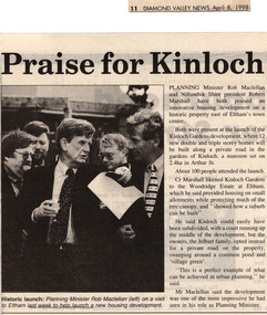
Drawing - Newspaper clipping, Praise for Kinloch, Diamond Valley News, April 8, 1998, p11, April 1998
... to Eltham last week to help launch a new housing development.... to Eltham last week to help launch a new housing development. Arthur ...PLANNING Minister Rob Maclellan and Nillumbik Shire president Robert Marshall have both praised an innovative housing development on a historic property east of Eltham's town centre. Both were present at the launch of the Kinloch Gardens development, where 12 new double and triple storey homes will be built along a private road in the gardens of Kinloch, a mansion set on 2.4ha in Arthur St. About 100 people attended the launch. Cr Marshall likened Kinloch Gardens to the Woodridge Estate at Eltham, which he said provided housing on small allotments while protecting much of the tree canopy, and "showed how a suburb can be built". He said Kinloch could easily have been subdivided, with a court running up the middle of the development, but the owners, the Jelbart family, opted instead for a private road on the property, sweeping around a common pond and 'village green'. ''This is a perfect example of what can be achieved in urban planning,'' he said. Mr Maclellan said the development was one of the most impressive he had seen in his role as Planning Minister Picture - Historic launch: Planning Minister Rob Maclellan (left) on a visit to Eltham last week to help launch a new housing development.Digital file only; created from scan undertaken by EDHS of item on loanarthur street, eltham, graeme gunn, houses, ian jelbart, jelbart property, kinloch gardens, rob maclellan, robert marshall, woodridge estate -
 Eltham District Historical Society Inc
Document - Series Listing, Fraser Faithfull et al, Series 13: Eltham Shire Photograph Album 1985, 2000
... , Housing Development, the Council Depot, Shire Offices, Eltham..., Housing Development, the Council Depot, Shire Offices, Eltham ...Series consists of 174 colour and B&W photographs of sites and activities in the Shire of Eltham. Most shots are 150mm by 100, though there are a number of smaller shots laid out in montages, and 6 large (A4 size) colour shots. Subjects documented include the Eltham Library, Eltham Lower Park, Eltham Senior Citizens Centre, Housing Development, the Council Depot, Shire Offices, Eltham Child Care Centre, Miniature Railway, Community Centre, the Bike Track, a Citizenship Ceremony, Shillingham Cottage, Eltham Town Park and other sites.shire of eltham archives, series listing -
 Broadmeadows Historical Society & Museum
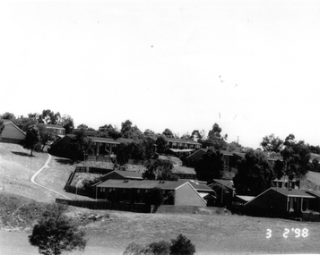
Photograph, Banksia Gardens Estate 1998, 3 February 1998
... Estate in Broadmeadows, a significant public housing development... Estate in Broadmeadows, a significant public housing development ...This photograph from 1998 captures the Banksia Gardens Estate in Broadmeadows, a significant public housing development of the time. The image provides valuable insight into the architectural design and living conditions within the estate during the late 1990s. Banksia Gardens was established to offer affordable and accessible housing, reflecting the social and economic priorities of the era. The estate served as a crucial community hub, fostering social connections and providing essential support to its residents. This photograph stands as a historical record of the efforts made to create stable and inclusive communities through public housing initiatives.This photograph of the Banksia Gardens Estate in Broadmeadows, taken in 1998, holds significant historical value. As a public housing estate, Banksia Gardens played a crucial role in providing affordable and accessible housing to the community. The image captures the essence of the estate's development during that period, reflecting the social and economic priorities of the late 1990s. Banksia Gardens served as a vital community hub, fostering social connections, providing essential support, and enhancing the quality of life for its residents. This photograph stands as a testament to the importance of public housing in creating stable and inclusive communities.Black and white photograph on glossy paper.Public Housing Estate/Banksia Gardens 1998/(Upside down bottom left corner) 28banksia gardens estate, broadmeadows, 1998 -
 Whitehorse Historical Society Inc.
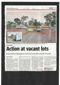
Article, Action At Vacant Lots, 2017
... care centre is being constructed and at No. 22 a housing... care centre is being constructed and at No. 22 a housing ...Two vacant properties in Blackburn Road, Blackburn at Nos 22 and 50 are finally being redeveloped. At No. 50 a child care centre is being constructed and at No. 22 a housing and retail development is expected.blackburn road, blackburn no. 50, blackburn no. 22, blackburn -
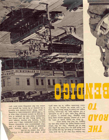 Ballarat Tramway Museum
Newspaper, The Walkabout Magazine, "The Road to Bendigo", Oct. 1974
... - Bogie tram on the Eaglehawk route prior to any nearby housing... to any nearby housing development - reclaimed mining land - has ...Yields information about the final day of the Bendigo tramways and some of the tramcars used.Three double sided sheets from "The Walkabout" magazine, October 1964, titled "The Road to Bendigo". Five printed pages featuring photographs of Bendigo, its buildings, its history stories, gold mining days and other information, including three illustrations containing trams. .1 - Charing Cross with bogies and single trucker - taken early 1960's. Photo by A. Doney. Features the intersection, with Ezywalkin store. Note the "Jeffrey's bread" roof advertisement on the single trucker. .2 - Bogie tram on the Eaglehawk route prior to any nearby housing development - reclaimed mining land - has Castrol roof advertisement - photo by Claver P Carroll. .3 - No. 6 outside The Beehive stores - 3BO - photo by Claver P Carroll. bendigo, eaglehawk, charing cross -
 Eltham District Historical Society Inc
Photograph, Kerb and channeling works, Beard Street and Main Road, Eltham, 3 Sep 1981
... . These images provide a perspective of housing estate developments.... These images provide a perspective of housing estate developments ...Roll of film taken by Eltham Shire Council officers of roads and houses in the Eltham East area, 3 September 1981 prior to construction of new water main; including views of existing damage to footpaths and gutters and general views of Beard Street. These images provide a perspective of housing estate developments and changes in housing styles and road development which began sweeping in from the mid 1970s with increasing urbanisation of what was once more outlying suburbs and regions.35mm colour positive transparency (1 of 28) Mount - Kodak Kodachrome Cardbeard street, eltham, footpaths and gutters, infrastructure, roads, main road -
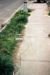
 Eltham District Historical Society Inc
Photograph, Beard Street, Eltham, 3 Sep 1981
... . These images provide a perspective of housing estate developments.... These images provide a perspective of housing estate developments ...Roll of film taken by Eltham Shire Council officers of roads and houses in the Eltham East area, 3 September 1981 prior to construction of new water main; including views of existing damage to footpaths and gutters and general views of Beard Street. These images provide a perspective of housing estate developments and changes in housing styles and road development which began sweeping in from the mid 1970s with increasing urbanisation of what was once more outlying suburbs and regions.35mm colour positive transparency (1 of 28) Mount - Kodak Kodachrome Cardbeard street, eltham, infrastructure, roads, horse, park road -
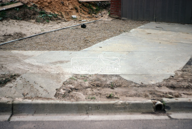
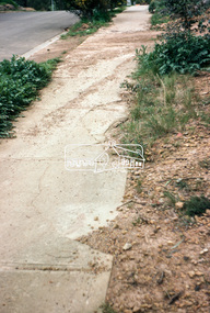
 Eltham District Historical Society Inc
Photograph, Foothpath and kerb damage, Bainbridge Drive, Eltham, 3 Sep 1981
... . These images provide a perspective of housing estate developments.... These images provide a perspective of housing estate developments ...Roll of film taken by Eltham Shire Council officers of roads and houses in the Eltham East area, 3 September 1981 prior to construction of new water main; including views of existing damage to footpaths and gutters and general views of Beard Street. These images provide a perspective of housing estate developments and changes in housing styles and road development which began sweeping in from the mid 1970s with increasing urbanisation of what was once more outlying suburbs and regions.35mm colour positive transparency (1 of 28) Mount - Kodak Kodachrome Cardeltham, infrastructure, roads, bainbridge drive, footpaths and gutters -
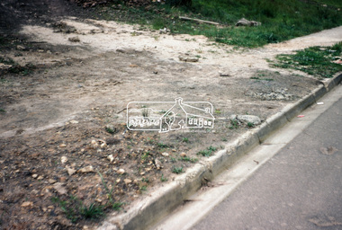
 Eltham District Historical Society Inc
Photograph, Foothpath and kerb damage, Madine Way, Eltham, 3 Sep 1981
... . These images provide a perspective of housing estate developments.... These images provide a perspective of housing estate developments ...Roll of film taken by Eltham Shire Council officers of roads and houses in the Eltham East area, 3 September 1981 prior to construction of new water main; including views of existing damage to footpaths and gutters and general views of Beard Street. These images provide a perspective of housing estate developments and changes in housing styles and road development which began sweeping in from the mid 1970s with increasing urbanisation of what was once more outlying suburbs and regions.35mm colour positive transparency (1 of 28) Mount - Kodak Kodachrome Cardeltham, infrastructure, roads, footpaths and gutters, madine way -
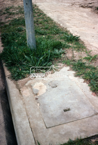
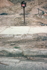
 Eltham District Historical Society Inc
Photograph, Madine Way, Eltham, 3 Sep 1981
... . These images provide a perspective of housing estate developments.... These images provide a perspective of housing estate developments ...Roll of film taken by Eltham Shire Council officers of roads and houses in the Eltham East area, 3 September 1981 prior to construction of new water main; including views of existing damage to footpaths and gutters and general views of Beard Street. These images provide a perspective of housing estate developments and changes in housing styles and road development which began sweeping in from the mid 1970s with increasing urbanisation of what was once more outlying suburbs and regions.35mm colour positive transparency (1 of 28) Mount - Kodak Kodachrome Cardeltham, infrastructure, roads, madine way, tadema park -
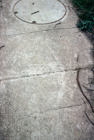
 Eltham District Historical Society Inc
Photograph, Beard Street, Eltham, 3 Sep 1981
... . These images provide a perspective of housing estate developments.... These images provide a perspective of housing estate developments ...Roll of film taken by Eltham Shire Council officers of roads and houses in the Eltham East area, 3 September 1981 prior to construction of new water main; including views of existing damage to footpaths and gutters and general views of Beard Street. These images provide a perspective of housing estate developments and changes in housing styles and road development which began sweeping in from the mid 1970s with increasing urbanisation of what was once more outlying suburbs and regions.35mm colour positive transparency (1 of 28) Mount - Kodak Kodachrome Cardeltham, infrastructure, roads, beard street, frank street, shalbury avenue