Showing 1102 items
matching information map
-
 Bendigo Military Museum
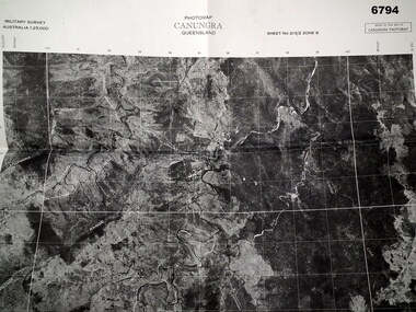
Map - MAP, CUNUNGRA, QLD, Royal Aust. Survey Corps, 1955
... This is a full size air photo map. It is black and white... information is printed in black ink around all four borders. Map MAP ...Canungra was the Jungle Warfare Training Centre (JTC) before and including 1968. Item in the collection re Lt.Col. Swatton refer Cat No 6719.2P for his service details.This is a full size air photo map. It is black and white. Some natural features are labelled with white printing. The air photo has a white border of approx 6.5 cms size. Map information is printed in black ink around all four borders.Map data = Military survey Australia 1:25,999 Sheet No. 213/2 Zone 8. Scale 1:25,000. Date = The air photo was taken Jan 1955. Map produced by R.A. Survey Corps 1955.passchendaele barracks trust, survey map -
 Orbost & District Historical Society
book, Report on the East Gippsland Study Area, June 1974
... maps and information on public land use in East Gippsland.... maps and information on public land use in East Gippsland ...In 1961 Bruce Evans was elected to the Victorian Legislative Assembly as the member for Gippsland East. He was the party's deputy leader from 1964 to 1970 and its whip from 1970 until his retirement in 1992. "The Land Conservation Council was established by the Land Conservation Act 1970. As one of its three functions, it makes recommendations to the Minister for Planning and Environment with respect to the use of public land, in order to provide for the balanced use of land in Victoria. This report contains the Council’s final recommendations concerning the use of public land in the East Gippsland study area, the boundaries of which correspond to those of the Shire of Orbost. The recommendations in the text are grouped under major headings, such as Parks, State Forest, and so on. " The Council met on seven occasions during the year, and also made visits of inspection to each study area. The Chairman visited Shire Councils in study areas to explain the role and the functions of the Land Conservation Council and to invite submissions on the use of public land in these areas. This is the fourth annual report by the council. This is a useful research tool.A large book 236 pp book with a yellow / gold cover with a green bush scene . The binding is orange. It contains folded maps and information on public land use in East Gippsland.inside - "With Compliments - Bruce Evans, M.P."east-gippsland-study-area conservation public-land-use -
 Federation University Historical Collection
Document - Documents and maps, Holmes - Documents, Letters, Family Trees, Maps
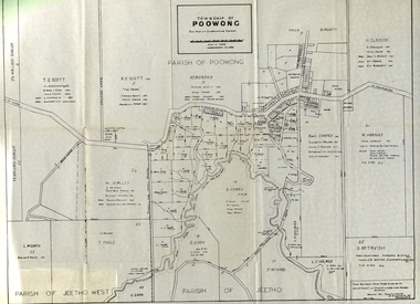
... Letters and maps and information relating to the Holmes... and maps and information relating to the Holmes family of Ascot ...Letters and maps and information relating to the Holmes family of Ascot, Victoria. Documents include: Sarah Holmes inquest Ancestors of Elizabeth Mary Holmes Holmes Family Reunion at Arawata Hallelizabeth mary holmes, ascot residence tender notice, family tree, map of poowong township, family history, genealogy, samuel pickford, william pickford, elizabeth cross, charles robbins, harry holmes, edith pickford, ian coghill holmes, elizabeth fry -
 Frankston RSL Sub Branch
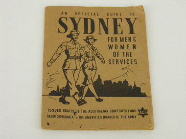
Handbook, An Official Guide to Sydney
... organisations, public transport information and a map. The book has 32... stationed or visiting there. Contains usefull information, contact ...Pocketbook produced by the Australian Comforts Fund as a guide to Sydney for service women and men stationed or visiting there. Contains usefull information, contact details for support organisations, public transport information and a map. The book has 32 pages and has a buff coloured paper cover. The booklet cover has the following printed in black ink: "An Official Guide to Sydney for Men & Women of the Services" "Issued by the Australian Comforts Fund (NSW Division) and the Amenities Branch of the Army" -
 Warrnambool and District Historical Society Inc.
Booklet - Warrnambool Visitor's Handbooks 1979-2024, Collett, Bain and Gaspar, Printers, 1979-2014
... Information Centre. They contain maps of Warrnambool, lists... Information Centre. They contain maps of Warrnambool, lists ...This is a collection of eight Warrnambool Visitor handbooks produced between 1979 and 2014 by the City of Warrnambool Tourist Information Centre. They contain maps of Warrnambool, lists of services, accommodation and tourist attractions as well as many advertisements for local businesses.These handbooks give a useful snapshot of businesses and tourist attractions in Warrnambool for each of the years covered. (1979, 1980, 1986, 1990, 1993, 1994, 1995, 2014)[.1a] A 48 page booklet with white pages and blue printing. The front cover has a coloured photograph of Flagstaff Hill with boats on a man made lake in the foreground looking across Lake Pertobe toward South Warrnambool. [.1b] A coloured bifold brochure. The front cover has a fisherman on a cray-boat holding a crayfish in the lower section. The top quarter has a blue back ground with white printing. The rear cover is red and has small photos of the Hopkins River and the Framlingham Forest. [.2] A 48 page booklet with white pages and black printing. The front cover is white with black writing on the left hand side and a colour photograph of the Loch Ard peacock. The Warrnambool Premier Town stylised logo of seven Norfollk pines above blue waves is in the top right hand corner. There is a blank ink Warrnambool Library stamp underneath the logo. The rear cover has photographs of The Twelve Apostles and the Hopkins Falls and the Premier Town Logo [.3] A 40 page booklet with mainly black printing on white paper. There are three fold out maps of Warrnambool and the surrounding district. The glossy cover has a black background with a colour photograph of the Twelve Apostles taken at sunset. The rear cover has three small of Proudfoot's boathouse on the Hopkins River, Flagstaff Hill, and the main beach area. The front cover has black writing inside to peach coloured rectangles. The inside rear cover has a fold out coloured tour map of Western Victoria. [.4] A 40 page booklet printed on glossy white paper with coloured photographs and black and red printing. The front cover has a photograph of The Twelve Apostles surrounded by a white border. There is red writing in the upper border. There is a sandy coloured writing superimposed across the bottom of the photograph and a Victoria's Shipwreck Coast logo in the bottom right hand corner. [.5] A 44 page booklet printed on white paper with black printing. The cream coloured cover has a pale red rectangle with blue writing on the right hand facing edge and includes two stylised Norfolk pines and with waves underneath. There is is an intersecting blue rectangle with cream printing. [.6] A 48 page booklet printed on white paper with black printing. The cover is brown with a cream vertical strip containing black writing on the right hand side. There is a stylised map from Geelong to Mount Gambier showing the Great Ocean Road across the cover. [.7] A 48 page booklet printed on white paper with black print. The glossy colour cover has a photograph of a Southern Right whale fluke. There is white printing on a the blue background of the sky and sea. The bottom left hand side of the front cover has a Tourism Victoria logo made of jigsaw puzzle pieces. The back cover has a stylised coloured map of The Great Ocean Road located in a white rectangle at the top of the page. Within the rectangle is a small map of Australia locating Victoria and the part of Victoria covered by the map. [.8] A 64 page A5 coloured booklet printed on white pages with black print. The white front cover has black and grey print with a colour photograph of two people holding coffee cups watching four race horses being exercised on the beach and in the water of Lady Bay in the early morning. The bottom right hand corner has a Tourism Victoria logo. The rear cover has a mainly blue back ground with a pink orange and green colour splats contains words advertising the 2015 Fun 4 Kids Festival [.1a] Warrnambool The Heart of Victoria's Great Southwest Visitor's Handbook [.1b] Warrnambool City for all seasons; The Heart of Victoria's Great Southwest [.2] Warrnambool visitor's handbook Warrnambool Premier Town 1979-1982 [.3] Warrnambool Handbook Victoria [.4] Warrnambool The Shipwreck Coast [.5] Welcome to Warrnambool Warrnambool Visitors Handbook 1993-1994 [.6] Welcome to Warrnambool Visitors Handbook 1994-95 Rear cover: Warrnambool Centre of Victoria's Shipwreck Coast on Australia's Great Ocean Road [.7] Warrnambool Shipwreck Coast - Great Ocean Road; You'll love every piece of Victoria; Visitors Handbook [.8] Warrnambool Great Ocean Road Official Visitor Guide; It's a wonderful Warrnambool; You'll love every piece of Victoria visitvictoria.com. Rear Cover Live entertainment.Workshops.Creativity.Action 28 June - 5 July 2015 Australia's Best Children's Festival F4K The ultimate winter school holiday adventure Fun 4 kids festival Warrnambool For more information visit Fun4kids.com.au Warrnambool great Ocean Road Victoriawarrnambool, visitor handbooks, tourist information guides, warrnambool maps -
 Greensborough Historical Society
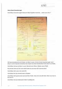
Article and Photograph, Henry Street Greensborough, 2017_
... Map and information about Henry Street Greensborough, map... Plenty Lower Plenty melbourne Map and information about Henry ...Map and information about Henry Street Greensborough, map drawn in 1999 by Valma Simpkins (nee Poulter) of residents and businesses in Henry Street near Grimshaw Street in the 1930s. Further discussion about Poulter and Clayton family connectionsThis photograph and text was copied from a Facebook site. Members are people who lived in the Greensborough area and share their reminiscences of the area with others. The site is administered by a GHS member but is not officially affiliated with the Society. Any information is the opinion of the contributor. Article and photograph sourced from social media.henry street greensborough, valma poulter, valma simpkins, clayton family -
 Falls Creek Historical Society
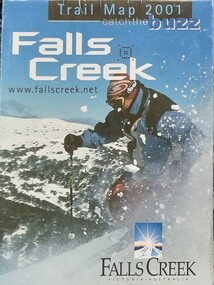
Booklet - Falls Creek Trail Guides 2001, 2003, 2005
... . They include extensive information about ski trails, maps as well.... They include extensive information about ski trails, maps as well ...These publications were developed by the Falls Creek Resort Management Committee to promote activities and facilities at Falls Creek for the Winter Seasons of 2001, 2003 and 2005. They include extensive information about ski trails, maps as well as ski and lift passes and packages.These items are important because they document seasonal activities at Falls Creek Alpine Resort over time.Three glossy coloured flyers featuring images and information about skiing and trails at Falls Creek. Prices for different lift passes, ski gear rental and season passes are included.falls creek marketing, lift passes, ski packages falls creek, falls creek trail maps -
 Hume City Civic Collection
Manual - Directory, SUNBURY/LOCAL INFORMATION/MANUAL 1983-84
... Information page and a map with street index. It has a Shire of Bulla... Information page and a map with street index. It has a Shire of Bulla ...This 1983-84 Sunbury local manual lists the names, addresses and telephone numbers of local residents and businesses as well as business advertisements. There is an index, a Useful Information page and a map with street index. It has a Shire of Bulla council service directory for Sunbury.A 90 Page local manual with a coloured photo of the Goonawarra Golf Club on the front cover.SUNBURY/LOCAL/INFORMATION/MANUAL 1983-84sunbury, directory, 1980s, residents, businesses., shire of bulla, civic, george evans collection -
 Bendigo Military Museum
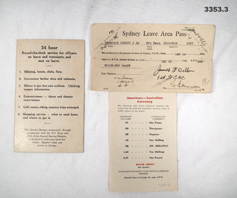
Administrative record - LEAVE PASS & INFORMATION CARDS, c.1942
... . Map & information on reverse side in black & red print. .2.... Map & information on reverse side in black & red print. .2 ...American Forces issue..1) Cream coloured Information card, black print on front. Map & information on reverse side in black & red print. .2) Cream coloured Sydney Leave Area Pass, black print. .3) Cream coloured Information sheet, paper, black & red print on both sides..2) Typed: “Sydney Leave Area Pass Thompson, Robert J Jnr, CPL Tech 33099209 Army from Dec 10 1943 to Dec 25 1943, APO 928 BRISBANE 2nd JN”administration, leave, pass -
Glenelg Shire Council Cultural Collection
Pamphlet - Pamphlets - Portland and surrounds, Victoria, n.d
... Collection of pamphlets, information and maps for seven...' -handwritten, blue biro, top right Collection of pamphlets, information ...Collection of pamphlets, information and maps for seven tourist tours of Portland and district. a. green Tour No. 1 Town of Portland b. pale yellow Tour No.2 Portland Harbour c. blue Tour No. 3 Scenic Drive d. gold Tour No. 4 Cobboboonee Forest e. yellow Tour No.5 Nelson, Glenelg River and caves f. pink Tour No. 6 Bridgewater Bay, Lakes, Blowholes g. orange Tour No. 7 Yambuk Lakes, Mt. ClayFront: 'VIVIAN' -handwritten, blue biro, top right -
 Melbourne Tram Museum
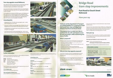
Pamphlet, VicRoads, "Bridge Road tram stop improvements", Sep. 2011
... , the background reasons, inviting people to have their say, information..., information sessions, maps, diagrams and contact details and survey ...Pamphlet, printed on cream recycled paper, A3 + and A4 tear off titled "Bridge Road tram stop improvements". giving details of the Punt Road to Church St section of Bridge Road tram line. Installation of two level access tram stops to replace the existing three - Vienna style. Has details on the proposal, the background reasons, inviting people to have their say, information sessions, maps, diagrams and contact details and survey form. 2 copies held.trams, tramways, bridge rd, tram stops, vienna style stops, vicroads, disability services -
 Melbourne Tram Museum
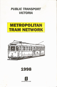
Book, Department of Infrastructure (DOI), "Metropolitan Tram Network", 1998
... on the cover along with a The Met logo. Provides information in map... on the cover along with a The Met logo. Provides information in map ...Book - 33 sheets + covers, stapled and cloth binding - special size, two colour - printed on off white paper, titled "Metropolitan Tram Network" published by Public Transport Corporation Victoria or Department of Infrastructure, with a drawing of SW5 758 on the cover along with a The Met logo. Provides information in map form on each tram route in a large print format, contact numbers and some general information. Follows on from an earlier version - see Reg Item 1181.trams, tramways, ptc, the met, maps, disability services, tram routes, routes, doi -
 Marysville & District Historical Society
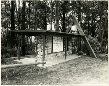
Photograph (Item) - Black and white photographs, Unknown
... of this structure. It contains maps and information for attractions.... It contains maps and information for attractions in and around ...Two black and white photographs of the tourist information board which is at the entrance to Marysville. The Marysville Tourist and Progress Association were responsible for the building of this structure. It contains maps and information for attractions in and around the local area as well as information pertaining to local clubs and organisations.Two black and white photographs of the tourist information board which is at the entrance to Marysville. The Marysville Tourist and Progress Association were responsible for the building of this structure. It contains maps and information for attractions in and around the local area as well as information pertaining to local clubs and organisations.marysville, victoria, marysville tourist and progress association, tourism information, tourism -
 Warrnambool and District Historical Society Inc.
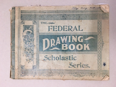
Booklet, The Federal Drawing Book Scholastic Series, C 1930
... contains maps and information on different countries around... contains maps and information on different countries around ...This school book which was owned by George Mathieson contains maps and information on different countries around the world. It is handwritten and is probably of secondary school level. The maps appear to have been traced and hand-drawn and coloured. There is a loose newspaper map of the Dardenelles loose in the book. This book as an example of school work and geography in the early 20th century, has social and historical significance.Pale green light card cover with dark green pattern and text. Back cover is plain. It contains alternate pages of tracing paper in between normal pages. Bound with cotton? threadGeorge mathieson, written in ink on front cover.federal drawing book, george mathieson, school drawing book 1920's, warrnambool -
 Bendigo Military Museum
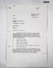
Letter - Army Survey Regiment - Letter of request for additional computer disk space for Automap 2, Army Survey Regiment, 19 Feb 1987
... Information System, and, Map Catalog Production.... Information System, and, Map Catalog Production. Royal Australian ...Automap 2 was the Army Survey Regiment's computerized Mapping system. This letter is a request for an additional 700 Mb of computer disk space for the Automap 2 System because of newly developed applications. Those applications were: Analytical Hill shading, Digital Terrain Modelling, Mask and stipple Production, RAAF Chart symbol Placement, ASTIS - Army Survey - Topographic Information System, and, Map Catalog Production.Two page letter, foolscap size, Stapled top left corner"A Spurling, Computer Operations Manager for CO"royal australian survey corps, rasvy, fortuna, army survey regiment, army svy regt, asr -
 Warrnambool and District Historical Society Inc.
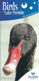
Document, Pamphlets lake Pertobe, 2014
... photographs of birds, two maps and information about BirdLife... photographs of birds, two maps and information about BirdLife ...Lake Pertobe in Warrnambool is a former swamp area which was transformed into a recreational area and children’s playground in the 1970s. The reserve is a popular spot for bird watching with over 80 species found in the vicinity. The brochure on Lake Pertobe’s birds had been produced by BirdLife Warrnambool, part of BirdLife Australia, an independent, not-for profit organisation aiming to protect our birdlife and disseminate information on Australian birds. This is an important little brochure as it contains information for locals and tourists about the birdlife in Lake Pertobe, one of the best-known and best-loved spots in WarrnamboolThis is an A3 sheet of paper printed on both sides and folded three times to form a brochure. It contains colour photographs of birds, two maps and information about BirdLife Warrnambool and BirdLife Australia and the logo of Birdlife Warrnambool.Front Cover: ‘Birds of Lake Pertobe, Warrnambool, BirdLife Warrnambool, Birds are in our nature’ lake pertobe, birdlife warrnambool, warrnambool -
Bendigo Historical Society Inc.
Book - BLUE GUIDE 1988, 1988
... Blue Guide 1988 - booklet of Bendigo information... information with illustrations and map. Includes emergency contaacts ...Blue Guide 1988 - booklet of Bendigo information with illustrations and map. Includes emergency contaacts, bus and rail timetables, telephone directory, services listing, Justices of the Peace. Booklet sent 'To the Householder' 56 pages plus loose map of BendigoBlue guide publicationsbendigo, hospital, bendigo, information booklet, blue guide. -
 Federation University Historical Collection
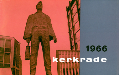
Promotional booklet about Kerkrade's music festival, Kerkrade 1966, 1966
... . This booklet contains information, photographs and a map of the venue.... This booklet contains information, photographs and a map of the venue ...Frank Wright was a renown resident of Smeaton, where he was born in 1901. He lived at Laura Villa, and attended Smeaton State School. His father William was a gold miner and his mother's name was Sarah. He was the youngest of eleven children. Their family won many singing and instrumental awards. Frank was tutored by Percy Code and was awarded a gold medal for the highest marks in the ALCM examinations in the British Colonies at the age of seventeen years. He became the Australian Open Cornet Champion by the age of eighteen. A year later, Frank conducted the City of Ballarat Band, and later the Ballarat Soldiers’ Memorial Band. He formed the Frank Wright Frisco Band and Frank Wright and his Coliseum Orchestra. These bands won many South Street awards, and Frank as conductor won many awards in the Australian Band Championship contest. In 1933 Frank Wright sailed to England to conduct the famous St Hilda’s Band and was appointed in 1934 as the Musical Director of the London County Council (the GLC or Greater London Council), where he organized many amazing concerts in most of the 150 parks, in and around the London district. He was also responsible for some of London’s major concerts at Kenwood, the Crystal Palace and Holland Park. He was made Professor of Brass and Military Band Scoring and Conducting and was a Fellow of the Guildhall School of Music and Drama. Frank was often invited to adjudicate Brass Band Championships around Europe, in Australia, including South Street and in New Zealand. Frank was awarded an M.B.E. in 1967 and he died in November 1970. The Frank Wright Medal at the Royal South Street competition is awarded to an individual recognized as making an outstanding contribution to brass music in Australia.Landscape produced with a two toned (red and blue) cover. This booklet contains information, photographs and a map of the venue of the world famous music festival held in the town of Kerkrade in the Netherlands. On one of the pages is a photograph and short bio of Frank Wright who was one of the adjudicators.frank wright, kerkrade, music festival -
 Victorian Aboriginal Corporation for Languages
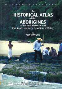
Book, Sue Wesson, An historical atlas of the Aborigines of Eastern Victoria and Far South-eastern New South Wales, 2000
... in eastern Victoria and south-eastern New South Wales. Includes maps.... Includes maps, census information about the numbers and makeup ...An extremely detailed atlas of tribes, clans, and languages in eastern Victoria and south-eastern New South Wales. Includes maps, census information about the numbers and makeup of these clans in historical records, meanings and comparative spellings of all known named tribes and clans.maps, b&w photographs, colour photographs, tables -
 Melbourne Tram Museum
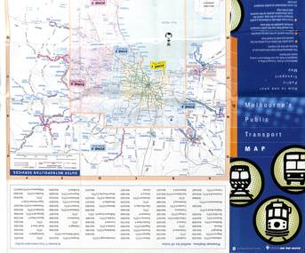
Map, Department of Infrastructure (DOI), "Melbourne's Public Transport Map", Jul. 1999
... . Gives rail and tram maps, information on tickets, zones (3... Trams tramways Map DOI Melbourne The Met Map - 18 fold - 6 x 3 ...Map - 18 fold - 6 x 3 with colour map of public transport including buses, titled "Melbourne's Public Transport Map", published by the Department of Infrastructure, Effective July 1999. Gives rail and tram maps, information on tickets, zones (3 Number) Has The Met contact details and website. Has DOI and State Govt logos. Priced $2.trams, tramways, map, doi, melbourne, the met -
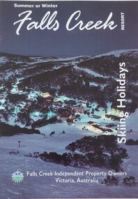 Falls Creek Historical Society
Booklet - Falls Creek Skiing Holidays 1993
... and travel information which features a map of Falls Creek Village... information which features a map of Falls Creek Village. Venues ...Part of a yearly marketing and information material promoting Falls Creek Region. It includes accommodation rates and travel information which features a map of Falls Creek Village. Venues included in the chart are:- Astra Lodge, Diana Lodge, Karelia Lodge, Snowdrift Lodge, Snowhaven, Viking Lodge, Alpine View Apartments, Cumings Holiday Apartments and Koki Apartments.This item is important as it documents seasonal activities and accommodation venues and rates at Falls Creek Village in the 1990s. An A4 size leaflet promoting Falls Creek of the ski season of 1993. An accommodation rates chart is included in the centre page.accommodation falls creek, falls creek marketing, falls creek tourism, skiing holidays victoria -
 Bendigo Historical Society Inc.
Document - ALBERT RICHARDSON COLLECTION: LADY BARKLY MINE, EAGLEHAWK
... One page document, plus map, with information on the Lady..., plus map, with information on the Lady Barkly Mine, New Chum ...One page document, plus map, with information on the Lady Barkly Mine, New Chum line of reef, Eaglehawk. The location, early history, prominence, and gold production are described. References given on bottom of document. Document forms part of research referred to in Albert Richardson's paper 2264.70.bendigo, mining, lady barkly mine eaglehawk -
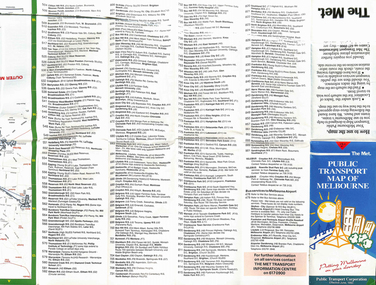 Melbourne Tram Museum
Map, The Met, "Public Transport Map of Melbourne", June 1992
... . Gives rail and tram maps, information on tickets. Has The Met... Trams tramways Map PTC Melbourne The Met Map - 36 fold - 9 x 2 x ...Map - 36 fold - 9 x 2 x 2- colour map of public transport including buses, titled "Public Transport Map of Melbourne", published by the Public Transport Corporation, Effective June 1992. Gives rail and tram maps, information on tickets. Has The Met contact details. 2 copies held .1 - as above but a 6 fold DL, dated Jan 8, 1995trams, tramways, map, ptc, melbourne, the met -
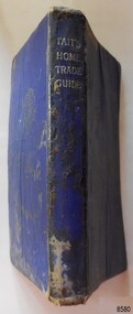 Flagstaff Hill Maritime Museum and Village
Book - Technical Reference, James Tait, Extra Master and Author et al, Tait's Home Trade Guide to the Board of Trade Examinations for Mates and Masters, 1943
... The book includes navigational information, tables and maps...The book includes navigational information, tables and maps ...The book includes navigational information, tables and maps, diagrams and formulas. It was written for Examiners and Students studying for their nautical Mates and Masters marine qualifications— notes have been handwritten inside the front and back covers. Notes in point form: 1. I have seen the back of a torpedo EBoat or UBoat in my starboard side 2. I _ _ _ to - - - - - - - - - Port side 3. at a distance ----------- 4. Enemy surface vessel in sight __________ 5. suspicious vessel in sight 6. enemy (undecipherable) 7. I have cut a _ _ _ adrift with my _ _ 8. FI_ _ WISE _ _ _ 9. STARWISE 0. OPEN FIREThis relatively rare book provided up-to-date navigational information during World War II. It was to be used by Examiners to assess whether students qualified to be a Ship's Mate or Ship's Master. The contents of the book were based on maritime knowledge gained over centuries. It is an aid to understanding the navigational methods of the time and the changes and improvements in more recent history.Title: Tait's Home Trade Guide: to the Board of Trade Examinations for Mates and Masters Author: James Tait, Extra Master Publisher: Brown, Son and Ferguson, Ltd. Glasgow, Great Britain Date: Revised Edition 1943 Further Information: Fourteenth Edition 1941, Reprinted Edition 1943. Revised and brought up to date by Captain H. T. Jefferys, Extra Master Printed by Nautical Press, Brown, Son & Ferguson, Limited, 52-58 Darnley Street, Glasgow Hardcover, small book, royal blue cover, silver embossed text on spine. Textbook for Mariners. Includes tables and maps, diagrams and formulas, and navigational information. The inside covers of this book contain handwritten calculations, diagrams and notes that refer to navigation. Notes inside the back cover refer to an enemy vessel and OPEN FIRE.Spint, in silver embossing "TAIT'S HOME TRADE GUIDE" Handwritten inside the back cover "R.A.D. / MOORE / PT. WELCH" Included with the text inside the back cover "Gascoyne" "506" and "RCM"flagstaff hill, warrnambool, shipwrecked coast, flagstaff hill maritime museum, maritime museum, shipwreck coast, flagstaff hill maritime village, great ocean road, james tait, brown, son and ferguson limited, torpedo, open fire, pt welch, vessel gascoyne, e-boat, u-boat, marine technology, world war ii, wwii, ww2, navigation exams, ship's mate, ship's master, wwii textbook, nautical textbook, navigational textbook, examination textbook, world war ii textbook, 1943 nautical textbook -
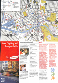 Melbourne Tram Museum
Map, City of Melbourne, "Inner City Transport Map", c1990
... Map", providing information for Tourist Information centres... Trams tramways Map Public Transport City of Melbourne Metlink ...Map - 6 fold DL - full colour titled "Inner City Transport Map", providing information for Tourist Information centres, Metlink. Melbourne City Tourist Shuttle, and two maps, one provided by Melway giving a list of attractions. Published by City of Melbourne, Melway and Metlink with each of their logos.trams, tramways, map, public transport, city of melbourne, metlink -
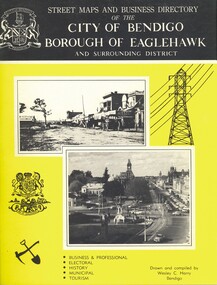 Bendigo Historical Society Inc.
Book - STREET MAPS AND BUSINESS DIRECTORY OF THE CITY OF BENDIGO, c1972
... photographs, illustrations & maps. Information on the shires that make..., illustrations & maps. Information on the shires that make up Bendigo ...Street Maps and Business Directory of the City of Bendigo Borough of Eaglehawk and Surrounding District : with Classified Business Directory (1973). Drawn and compiled by Wesley C Harry. Publisher: Cambridge Press, Bendigo. 88 pages. Includes b/w photographs, illustrations & maps. Information on the shires that make up Bendigo. History of the name of Bendigo. Historical pictures with notes. Advertisements for local businesses. Signed - Alec S Craig, mayor. Grace A. O. CraigWesley C Harrybook, bendigo, bendigo & district maps, streets & localities bendigo & district, businesses, historical notes of bendigo -
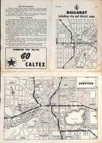 Ballarat Tramway Museum
Map, RACV - Royal Automobile Club of Victoria, "Ballarat including city and district maps", 10/1961
... , streets, principal attractions, Ballarat and district maps..., Ballarat and district maps and information. Has the tram lines ...Shows the central part of Ballarat, Ballarat Outlets, streets, principal attractions, Ballarat and district maps and information. Has the tram lines shown dotted, does not run out to Sebastopol or the Lydiard St North terminus. Each map in the bottom left-hand corner has the number "1061", possibly indicating the date. Has notes on the City, points of interest, and an advertisement for Caltex. See item 4929 for a larger version dated 1966. Yields information about the extent of Ballarat in the early 1960's shows the tram lines and other rail lines in the district. Four fold map printed on white paper, titled "Ballarat including city and district maps" - Map No. MAP 15.314 and dated 10-61. Produced by the RACVmap, tranways, ballarat, racv, railways -
Federation University Historical Collection
Map - Plan, Ballarat Deep Leads and Mines, 1992, 1992
... . this rectangle includes information of the other maps shown... and information on mines in the following areas: one large map ...This is Bulletin No. 62: Deep Lead Gold Deposits in Victoria. Map No.6 Ballarat Sheet 1 of 2 The map shows geology, topography and information on mines in the following areas: one large map of the Ballarat area with five enlargements for: Sago Hill District; Scarsdale District; Pitfield Plains District; Berringa Gold Field and Rokewood District. Ballarat Mines and Deep Leads Report No.94 (Finlay and Douglas,1992) provides a summary of the Geological Survey of Victoria mines database, references and geology for most of the mines on this map. Geology Compilation: simplified from earlier Departmental mapping with minor field checking by E.N.M. Plier-Malone. Very large rectangular sheet of paper with seven coloured maps of various sizes and a small green rectangle on the bottom rhs with a map of Victoria superimposed over a poppet head. this rectangle includes information of the other maps shown. The background for these maps is white. Also includes tables of names of mine companies, name of shafts and gold production.gold mines of australia, gold mines of victoria, gold mines- ballarat and district, gold mines pitfield plains district, gold mines scarsdale district, gold mines berringa gold field, gold mines rokewood district, gold mines sago hill district, map - gold mines, map - gold mines in victoria, ballarat, pitfield, scarsdale, berringa, rokewood, sago hill, deep lead gold deposits in victoria, geological survey - gold deposits in victoria, mining, gold deposits in victoria, gold mines in victoria, rokewook, pitfield plains -
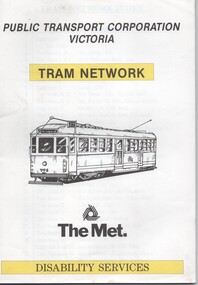 Melbourne Tram Museum
Book, Public Transport Corporation (PTC), "Tram Network Disability Services", c1990
... on the cover along with a The Met logo. Provides information in map... on the cover along with a The Met logo. Provides information in map ...Book - 36 sheets - A4, two colour - printed on off white paper, titled "Tram Network Disability Services" published by Public Transport Corporation Victoria, with a drawing of SW5 758 on the cover along with a The Met logo. Provides information in map form on each tram route in a large print format, contact numbers and some general information. No date of publication. Port Melbourne route shown as route 111; Reg Item 252 notes that this route ran between Port Melbourne and the Exhibition Buildings between 12/1987 and 12/1993. See Reg Item 1865 for pamphlet version and 6000 for a PTC 1998 version. 2nd copy added 24-5-2023 - larger size issue - 248H x 242W - wire boundtrams, tramways, ptc, the met, maps, disability services, tram routes, routes -
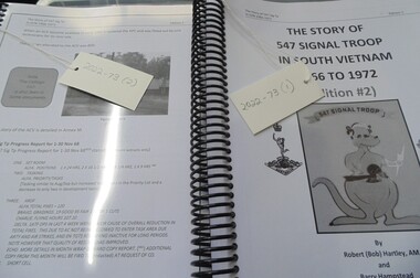 National Vietnam Veterans Museum (NVVM)
Booklet - Unit History, The Story of 547 Signal Troop/1966/1972/Edition #2
... images, maps, operational information and first hand accounts... images, maps, operational information and first hand accounts ..."The Story of 547 Signal Troop in South Vietnam 1966 to 1972", by Robert (Bob) Hartley, AM and Barry Hampstead. The manuscript tells the story of the unit, including its establishment, training, deployment, personnel, general life and operations while in Vietnam, the withdrawal, and return to Australia. It contains images, maps, operational information and first hand accounts of soldiers' experiences. This item contributes to an understanding of how Australia's involvement in the war in Vietnam (1962-1975) had a lasting impact on Australian servicemen.2 spiral- bound copies of booklet contains 691 pages of black and white writing, maps and photographs. Front page image is of a kangaroo holding lightning bolt with "Snoopy" in pouch. 547 signal, snoopy, robert hartley, signals, hartley