Showing 1204 items
matching land for sale
-
 Ringwood and District Historical Society
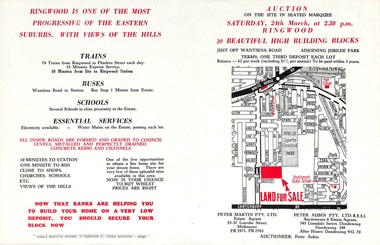
Flyer, Land Auction Advertisement adjoining Jubilee Park, Ringwood, Victoria - 1956
... Folded double-sided brochure advertising residential land...-sided brochure advertising residential land sale auction ...Folded double-sided brochure advertising residential land sale auction on Saturday 24th March (1956), with locality map and subdivision layout, terms of sale, and summary of local features and services. Subdivision includes Reilly Street Ringwood, and Philip Street, Daisy Street, and Lorienne Street Heathmont. Surveyors - Messrs Little and Brosnan. Agents in Conjunction - Peter Martin Pty. Ltd., Estate Agents, 55-57 Latrobe Street, Melbourne (Phone) FB 3571, FB 2783, and Peter Aubin Pty. Ltd. R.E.S.I., Auctioneers & Estate Agents, 345 Lonsdale Street, Dandenong (Phone) Dandenong 340, After Hours, Dandenong 932, 70. -
 Tatura Irrigation & Wartime Camps Museum
Poster, Subdivision of Township Allotments
... Single sheet of paper, laminated. Advertising land... Allotments Single sheet of paper, laminated. Advertising land ...Poster depicting the land which was being sold by J S Darby on the 3 December 1890. Auctioneer was Martin Cussen and Co. Map shows location of land.Single sheet of paper, laminated. Advertising land subdivision for sale in the township of Rushworth. Being sold by Martin Cussen and Co, auctioneers for J S Darby. Shows map of land subdivision.rushworth, land subdivision, martin cussen and co, j s darby -
Whitehorse Historical Society Inc.
Document, What happened to Norwich?
... of Nunawading, County of Bourke, found on a land sale map in the La..., County of Bourke, found on a land sale map in the La Trobe ...Norwich, consisting of 475 acres in the Parish of Nunawading, County of Bourke, found on a land sale map in the La Trobe collection of Vale maps.Norwich, consisting of 475 acres in the Parish of Nunawading, County of Bourke, found on a land sale map in the La Trobe collection of Vale maps. Research by Jean Uhl into the fate of the proposed township.Norwich, consisting of 475 acres in the Parish of Nunawading, County of Bourke, found on a land sale map in the La Trobe collection of Vale maps. local history, uhl, jean, parish of nunawading, norwich village, vermont, lobb, john, graham, thomas -
Whitehorse Historical Society Inc.
Letter - Correspondence, Samuel and Ivy Davidson, 10/07/1992 12:00:00 AM
... Letter from Jean Mannix accompanying photo and land sale... Letter from Jean Mannix accompanying photo and land sale brochure ...Letter from Jean Mannix accompanying photo and land sale brochure with details of her family - parents, Samuel and Ivy Davidson and brother Donald from the Blackburn area. Ref: NP977; ND2809Letter from Jean Mannix accompanying photo and land sale brochure with details of her family - parents, Samuel and Ivy Davidson and brother Donald from the Blackburn area. Ref: NP977; ND2809Letter from Jean Mannix accompanying photo and land sale brochure with details of her family - parents, Samuel and Ivy Davidson and brother Donald from the Blackburn area. Ref: NP977; ND2809blackburn, davidson, samuel graham, davidson, ivy may, brennan, ivy may, davidson, jean iona, mannix, jean iona, davidson, donald kevin, mascot estate, blackburn -
 National Wool Museum
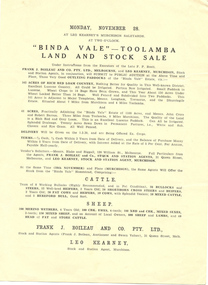
Brochure, "Binda Vale" Toolamba land and stock sale
... "Binda Vale" Toolamba land and stock sale..."Binda Vale" Toolamba land and stock sale Monday November... sale "Binda Vale" Toolamba land and stock sale Monday November ..."Binda Vale" Toolamba land and stock sale Monday November 28" Leo Kearneypastoral industry - history, binda vale, toolamba -
 City of Kingston
Pamphlet - Colour, R. Malcolm Estate Agents et al, Last Chance Land Sale Heritage Estate Cheltenham, c.1994
... Last Chance Land Sale Heritage Estate Cheltenham...Colour pamphlet advertising last chance land sale..., Tintern Grove and Tintern Mews This land sale pamphlet illustrates ...Sales plan for land in the suburb of Cheltenham, bounded by Chesterville Road and Bernard Street, and incorporating Clendon Court, Tintern Grove and Tintern MewsThis land sale pamphlet illustrates one of the last subdivisions of the century in Cheltenham, incorporating house and land packages. It shows that land sales and subdivision for the area had slowed considerably by the end of the 1900s and that the infrastructure was significantly developed. Colour pamphlet advertising last chance land sale of Heritage Estate Cheltenham. Incorporates a map of the estate bordered by Chesterville Road and Bernard Street, and including Clenton Court, Tintern Grove and Tintern Mews.cheltenham, land sales, estate -
 Ringwood and District Historical Society
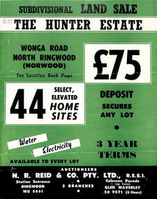
Flyer, Land Sale Brochure, The Hunter Estate, North Ringwood, Vic. - circa 1960
... Land Sale Brochure, The Hunter Estate, North Ringwood, Vic...Bi-fold land sale advertisement for The Hunter Estate... Road Ringwood North melbourne Flyer Land Sale Brochure ...Bi-fold land sale advertisement for The Hunter Estate, North Ringwood, including terms of sale, area map, layout of the estate, and summary of local facilities and services, with separate attachment listing lot number prices.Subdivision includes Wonga Road, Hunter Avenue (later Graeme Avenue), Panfield Avenue, Hendra Grove, and Mullum Mullum Road. Agent - N.R. Reid & Co. Pty. Ltd., Station Entrance, Ringwood. (Phone) WU 6661. -
Whitehorse Historical Society Inc.
Article, Carving up the Eastern Suburbs
... , and the 'Queens Park Tenner' issued as a deposit for a land sale, cnr...' issued as a deposit for a land sale, cnr Station Street ...Newspaper article about Tommy Bent and Sir Benjamin Benjamin and their land buys in the Eastern SuburbsNewspaper article about Tommy Bent and Sir Benjamin Benjamin and their land buys in the Eastern Suburbs, and the 'Queens Park Tenner' issued as a deposit for a land sale, cnr Station Street and Canterbury Roads (copy shown)Newspaper article about Tommy Bent and Sir Benjamin Benjamin and their land buys in the Eastern Suburbsland subdivision, station street, box hill, canterbury road, bent, thomas, benjamin, benjamin (sir), queens park estate, queens park tenner, freehold investment and banking company of australia ltd -
 Bendigo Historical Society Inc.
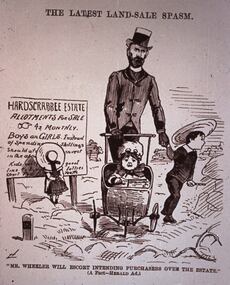
Slide - DIGGERS & MINING. LIFE OF THE SELECTORS, c1884
... 'The Latest Land-Sale Spasm.' Under picture ''Mr Wheeler Will Escort... & Mining. Life Of The Selectors. Slide headed 'The Latest Land-Sale ...Diggers & Mining. Life Of The Selectors. Slide headed 'The Latest Land-Sale Spasm.' Under picture ''Mr Wheeler Will Escort Intending Purchases Over The Estate.'' (A Fact - Herald Ad.) Ad on sign board is advertising Hardscrabble Estate Allotment For Sale 4s Monthly BOYS and GIRLS Instead Of Spending . . . Picture depicts a gentleman with 3 children one in pram. Markings: Life Of The Selectors 1860 - 1890 Set 432 No. 19. The Latest Land Sale Spasm - ''Sydney Bulletin,'' August 23, 1884. Used as a teaching aid.Visual Education Centreeducation, tertiary, goldfields -
 Bendigo Historical Society Inc.
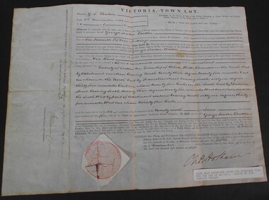
Document - WES HARRY COLLECTION: SALE OF LAND ALLOTMENT 20 IN TOWNSHIP OF WHITE HILLS DATED 5TH NOVEMBER 1855, 1855
... WES HARRY COLLECTION: SALE OF LAND ALLOTMENT 20 IN TOWNSHIP...Land Sale Agreement dtaed 5th November 1855 signed... and fifteen shillings Document WES HARRY COLLECTION: SALE OF LAND ...Land Sale Agreement dtaed 5th November 1855 signed and selaed by Charles Hotham Allotment 20 Section 10 Township of White Hills Sold to George Souter Butter for the sum of six pounds and fifteen shillings -
 Ringwood and District Historical Society
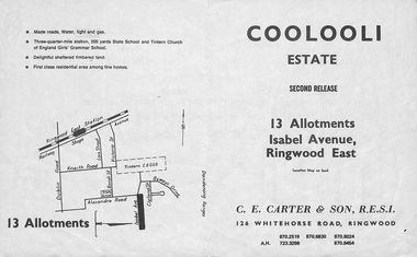
Flyer, Land Sale Brochure, Coolooli Estate, Ringwood East, Vic. - Second Release - c.1970
... Land Sale Brochure, Coolooli Estate, Ringwood East, Vic...Double sided folded land sale brochure - Coolooli Estate... Road Ringwood North melbourne Flyer Land Sale Brochure ...Refer also to Reg. No.5117 for Coolooli Estate first release allotments auction details, Reg. No.5119 - third release, Reg. No.5120 - final release.Double sided folded land sale brochure - Coolooli Estate Second Release, 13 allotments, Isabel Avenue, Ringwood East. Includes location map and summary of local facilities, services and separate page outlining prices and terms.Subdivision includes Isabel Avenue and proposed road - Walhalla Drive. (Agents) C.E. Carter & Son, 126 Whitehorse Road, Ringwood - Tel. 8706024, 8706830, 8702519, A.H. 7233298, 8706454. -
 Kilmore Historical Society
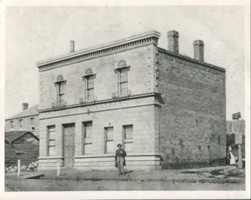
Photograph, Oriental Bank Corporation, 1866
... . A sign on post at back of building reads: Land for Sale Apply.... A sign on post at back of building reads: Land for Sale Apply ...This photograph was most likely taken for the 1866 Intercolonial Exhibition in Melbourne.25cm x 20cm black and white reproduction of a photograph of the Oriental Bank Corporation, 7 Sydney Street Kilmore, from the State Library of Victoria. Double storey building with decorative parapet along roofline, wrought iron balconets at upper storey windows, decorative hood molds above windows, name of bank in stone under ground floor cornice, a man standing on path in front of bank. Woman standing at back of building in shadow. A sign on post at back of building reads: Land for Sale Apply to W. Grace Solicitor Kilmore.Printed on back: REPRODUCTION RIGHTS RESERVED Copied by State Library of Victoria Tenders called for erection of this building in March 1864.banks, 19th century -
 Ringwood and District Historical Society
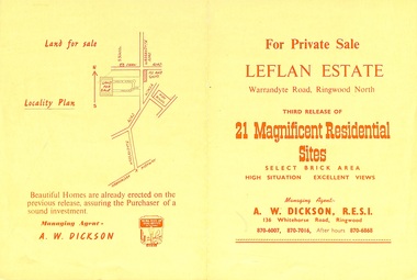
Flyer, Land Sale Brochure, Leflan Estate, North Ringwood, Vic. - 1967
... Land Sale Brochure, Leflan Estate, North Ringwood, Vic...Bi-fold land sale advertisement for Leflan Estate, Ringwood... Road Ringwood North melbourne Flyer Land Sale Brochure, Leflan ...Bi-fold land sale advertisement for Leflan Estate, Ringwood North, (third release of residential sites). Brochure includes area map, layout of the estate, and summary of local facilities and services, with separate attachment listing lot number prices.Subdivision includes Melview Drive, Leslie Grove, and Leflan Close. Agent - A.W. Dickson, R.E.S.I., 136 Whitehorse Road, Ringwood. (Phone) 870-6007, 870-7016, After hours 870-6868. -
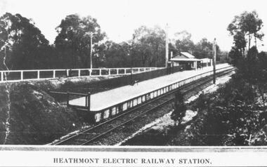 Ringwood and District Historical Society
Photograph, Heathmont Railway Station, 1926. Image taken from a land sale brochure advertising Charm-View Estate Sub-division opposite the station
... Heathmont Railway Station, 1926. Image taken from a land.... Land Sale - Heathmont Electric Railway Station right opposite... Station, 1926. Image taken from a land sale brochure advertising ...Written on back of photograph, "Photo taken from Sub. Div. Land Sale - Heathmont Electric Railway Station right opposite Estate. Charm-View Estate. Heathmont (For private Sale), 1926?" -
 Eltham District Historical Society Inc
Newsletter, No. 5, March 1979
... Contents: • Annual General Meeting • Early land sale... • Early land sale documents • Recent activities • Recognition ...Contents: • Annual General Meeting • Early land sale documents • Recent activities • Recognition of pioneers and local people • Society speakers • Committee meeting The Shire of Eltham Historical Society was formed in October 1967. The first newsletter of the Society was issued May 1978 and has been published continuously ever since on a bi-monthly basis. With the cessation of the Shire of Eltham in late 1994, the Society's name was revised to Eltham District Historical Society and this name first appeared with issue No. 103, July 1995. The collection of the Society's newsletters provides a valuable resource on the history of the Society's activities, office bearers and committee members, guest speakers and subjects of historical interest pertinent to the former Shire of Eltham and the Eltham District.A4 photocopied newsletter distributed to membersnewsletter, eltham district historical society, shire of eltham historical society -
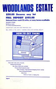 Ringwood and District Historical Society
Flyer, Land Sale Advertisement - Woodlands Estate, North Ringwood, Victoria - circa 1970
... Land Sale Advertisement - Woodlands Estate, North Ringwood...Double sided single-page advertisement for land sale... Road Ringwood North melbourne Flyer Land Sale Advertisement ...Double sided single-page advertisement for land sale with locality map and layout of Woodlands Estate subdivision in North Ringwood, with summary of local features and services. No indication of date of flyer other than post-Eastland Shopping Centre opening in 1967.Subdivision includes Oban Road, Terrigal Close, Dorelaw Drive (later Melview Drive), Naroo Court, and Barook Court. Agent's rubber stamp imprint - H.C. Walton & Son, 264 Doncaster Road, North Balwyn. -
 Ringwood and District Historical Society
Plan, Ringwood Station Estate, Subdivision, Ringwood, Victoria - circa 1925
... allotments for sale, with two typed pages attached showing land title... pages attached showing land title information and sale prices ...ID 5224 note: Further information relating to squares marked H, F, G, J, and K included in ID 5225 - Ringwood Shop and Dwelling Estate.Hand drawn plan of Ringwood Station Estate showing allotments for sale, with two typed pages attached showing land title information and sale prices.Drawn by Edyth Greenwood, phone 988 Central. Subdivision includes Station Street, Pitt Street, Bedford Road, Wantirna Road, James Street, William Street (later Kendall Street), Greenwood Avenue, Ellison Street, and Haig Street. Circles denote blocks for sale. Squares denote house properties for sale. Other features marked include location of businesses along Main Street (Maroondah Highway), cool store, railway station, shop and police station on Bedford Road, church on Station Street, site of schoolmaster's residence and State School, and location of proposed public baths. Ryner & Langford, Solicitors -
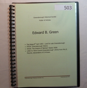 Greensborough Historical Society
Folder, Edward B. Green, 1853o
... Contents: Land sale for Greensborough (The Argus 1853... Historical Society. Folder commenced 2012. Contents: Land sale ...Contents: Land sale for Greensborough (The Argus 1853); Article: Greensborough history; Article: The Greens of Barham Station NSW; letter to Shire council from descendant of E B Green. History of the origins of Edward Bernard Green after whom Greensborough was named.20-page plastic binder, spiral bound, clear cover. Contains documents relating to Edward B. Green and family.Collected by Greensborough Historical Society. Folder commenced 2012.greensborough, edward bernard green -
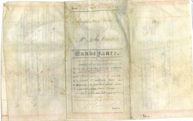 Bendigo Historical Society Inc.
Document - INDENTURE OF 1856 LAND SALE
... INDENTURE OF 1856 LAND SALE...Four pages photocopy of indenture for sale of land... photocopy of indenture for sale of land in Sandhurst in 1857 between ...Four pages photocopy of indenture for sale of land in Sandhurst in 1857 between Mr. Augustus Keith and Mr. John Brocker. Also stapled to the photocopies an hand written note: photocopy of original indenture of 1856 land sale, Bendigo. Original in possession of Jim Bowman and in pencil huntly (?)bendigo, land sales, mr augustus keith to mr john brocker -
 Eltham District Historical Society Inc
Newsletter, Eltham District Historical Society, Newsletter, No. 241 August 2018
... – Childhood Reminiscences – Part 5 by Ann Constable • Land for Sale... 1950s – Childhood Reminiscences – Part 5 by Ann Constable • Land ...Contents: • Finding a Home by Russell Yeoman • Our Next Meeting – Wednesday 8th August 2018 • Open Day at our Local History Centre – Saturday 1st September 2018 • Eltham 1950s – Childhood Reminiscences – Part 5 by Ann Constable • Land for Sale at Little Eltham by Russell Yeoman • The County of Evelyn by Russell Yeoman • An ‘enlightening’ tale by Jim Connor • The Andrew Ross Museum by Mick Woiwod • Kangaroo Ground – Centre of the Shire by Mick Woiwod • On the Thirsty Road to the Diggings by Mick Woiwod • Contacts for the Eltham District Historical Society The Shire of Eltham Historical Society was formed in October 1967. The first newsletter of the Society was issued May 1978 and has been published continuously ever since on a bi-monthly basis. With the cessation of the Shire of Eltham in late 1994, the Society's name was revised to Eltham District Historical Society and this name first appeared with issue No. 103, July 1995. The collection of the Society's newsletters provides a valuable resource on the history of the Society's activities, office bearers and committee members, guest speakers and subjects of historical interest pertinent to the former Shire of Eltham and the Eltham District.A4 newsletter distributed to membersnewsletter, eltham district historical society -
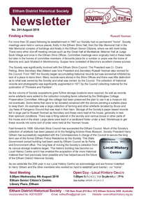
 Kew Historical Society Inc
Plan - Subdivision Plan, Romsey Rise, Doncaster East
... Real estate brochure for a land sale of 86 sites in East... brochure for a land sale of 86 sites in East Doncaster. Roads ...Real estate brochure for a land sale of 86 sites in East Doncaster. Roads identified in the plan include: George Street, Dennert Street, Worthing Avenue, Sandhurst Street, Belinda Crescent, and Romsey Rise.Historic subdivision plan of a Doncaster East EstateFour page colour real estate brochure including on page 2 a subdivision plan for the Romsey Rise estate in East Doncaster. This record also includes a separate price list for the lots.real estate plans, subdivision plans - doncaster east, romsey rise estate - doncaster east (vic) -
Southern Sherbrooke Historical Society Inc.
Map - photocopy, Woodcock & McCormack, civil engineers & architects & surveyors, The Major Estate, Belgrave
... A photocopy taken from the original land sale map provided... land sale map provided to the society through Karel Coxell ...A photocopy taken from the original land sale map provided to the society through Karel Coxell of Stockdale & Leggo. The original maps are stored in large bound account books and were originally the propert of McNally Real Estate. The books are held (in 22 A3 sheets. Shows The Serpentine between Government Rd (now Sandells Rd) and Government Rd(now Terrys Ave), Belgrave. Arrows to Belgrave, Sherbrooke Falls, Main Rd and store.land sales, advertisement, real estate subdivision, t. mahoney -
Southern Sherbrooke Historical Society Inc.
Map - photocopy
... A photocopy taken from the original land sale map provided... in pencil to copy. A photocopy taken from the original land sale map ...A photocopy taken from the original land sale map provided to the society through Karel Coxell of Stockdale & Leggo. The original maps are stored in large bound account books and were originally the propert of McNally Real Estate. The books are held (in 2A3 photocopy of plan of survey of part of Crown Allotments 20 & 21, section C, parish of Narre Worran, County of Mornington. Clements Ave and environs in Belgrave Heights"Villette Estate" in top LH corner, "Locality Plan" in bottom LH corner, "Not in sale" written on one block and crossed out. All handwritten in pencil on original. "Colby Drive " and "Verona Street" added in pencil to copy.land sales, advertisements, subdivision -
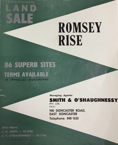
 Orbost & District Historical Society
poster, 1898
... was owned by his son, Rupert who offered the land for sale at 4... by his son, Rupert who offered the land for sale at 4 pounds per ...This poster was made for the sale of the 1,440 acres of Orbost Station after the death of Sir William Clarke. It was sold by Edward Trenchard & Co. which was the oldest Stock and Station agent in Victoria assisted by Desailly, Macarthur & Co were livestock experts. Sir William Clarke had taken over the Orbost run from the McLeods in 1870. When Sir William died the property was owned by his son, Rupert who offered the land for sale at 4 pounds per acre. No sale resulted and the property was leased for a few years until in 1898 it was subdivided and sold to many of Orbost's first families. (info. from In Times Gone By- Deborah Hall)This is an important reminder of the very early history of the settlement of Orbost.A rectangular paper poster for the sale of the Orbost Estate on Forest Road, Orbost. It is dated "Thursday Dec 1898" and was made for the sale of the 1,440 acres of Orbost Station after the death of Sir William Clarke. The poster gives written details of the sale and a plan of the property.orbost-station clarke-sir-william orbost-estate -
 Port Fairy Historical Society Museum and Archives
Book, The Historical Committee Of Portland, The Portland Bay Settlement, 1934
... including "List of Purchasers at original land sale", "First... including "List of Purchasers at original land sale", "First ...Aboriginal resistance to settlement, Native Police Force, G.A. Robinsons proposal to re-settle Flinders Island people and extracts fom his 1841 expedition report. Contents I. The early navigators and explorers II. Sealers and whalers and tales of the sea III. The Hentys and Victoria's first permanent settlement IV. Early incidents and personalities V. Under government control Vi. Social life and activities VII. The story of the press VIII. Business, professions and industry IX. Hotels and roads X. Sport XI. Environs of Portland XII. Miscellaneous historical items.8vo; pp. x, 285; frontispiece, numerous b/w illustrations, plans and maps two of which are folding, index, appendices including "List of Purchasers at original land sale", "First Election List", "Subscription lists for both First Church of England and First Presbyterian Church", original blue cloth, title in gilt on spinenon-fictionAboriginal resistance to settlement, Native Police Force, G.A. Robinsons proposal to re-settle Flinders Island people and extracts fom his 1841 expedition report. Contents I. The early navigators and explorers II. Sealers and whalers and tales of the sea III. The Hentys and Victoria's first permanent settlement IV. Early incidents and personalities V. Under government control Vi. Social life and activities VII. The story of the press VIII. Business, professions and industry IX. Hotels and roads X. Sport XI. Environs of Portland XII. Miscellaneous historical items.robinson, george augustus, 1791-1866., government policy - initial period and protectionism - 1788-1850., government policy - state and territory - victoria., law enforcement - police - native police., race relations - violent - massacres, murders, poisonings etc. - to 1900., sport., pioneers -- victoria -- portland., portland (w vic sj54-11), portland (vic.) -- history., book -
 Phillip Island and District Historical Society Inc.
Photograph, 1978/9
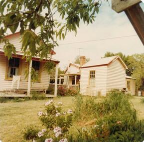
... arrived on Phillip Island in 1868 when the first land sale took... on Phillip Island in 1868 when the first land sale took place ...The house was built by William Richardson who went to live at Rhyll in 1876. His father, Joseph, owned the land. Joseph had arrived on Phillip Island in 1868 when the first land sale took place. Charlie, William's son, grew up in the house with his parents, brothers and sisters.Coloured photograph showing the kitchen at William Richardson's house in Rhyll.local history, photographs, buildings - historical, housing, coloured photograph, john cook, phillip island, charlie richardson -
 Phillip Island and District Historical Society Inc.
Photograph, 1978/79
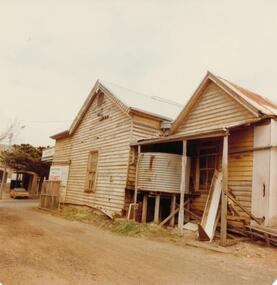
... January 1869 at the first land sale in Cowes, John West... land sale in Cowes, John West bought Lot 1 for £45 ...January 1869 at the first land sale in Cowes, John West bought Lot 1 for £45 . In the 1870's he built the first Chicory Kiln on Phillip Island. With his brother, Solomon, he started the General Store next to the Chicory Kiln in Thompson Avenue. Over the years the original building was extended and altered.Photograph of remains of West's store, Cowes. Timber building with corrugated roofing. Old iron water tank in front of building.local history, photographs, buildings, historic, buildings - historical, sepia photograph, john cook, phillip island, west's general store -
 Orbost & District Historical Society
black and white photograph, early 20th century
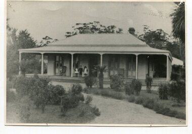
... who offered the land for sale at 4 pounds per acre. No sale... who offered the land for sale at 4 pounds per acre. No sale ...The McLeods, were the original holders of the Orbost station. Sir William Clarke bought the station from McLeod Bros. Sir William was a very fine man and noted for his philanthropic actions. He finally cut up and sold the Orbost station and presented 10 acres of land to the people of Orbost for a show and recreation ground. Sir William Clarke had taken over the Orbost run from the McLeods in 1870. (more info. July 2006 Newsletter) When Sir William died the property was owned by his son, Rupert who offered the land for sale at 4 pounds per acre. No sale resulted and the property was leased for a few years until in 1898 it was subdivided and sold to many of Orbost's first families. (info. from In Times Gone By- Deborah Hall) This house was located on the western side of Forest Road. Orbost.This is a pictorial record of one of the first residences in Orbost.A black/ white photograph of a large wooden house. It has a verandah at the front and sides. There are three children two girls and a boy - standing on the verandah to the left of the door. The house is surrounded by gardens.on front - Orbost Home Stationorbost-station clarke-william clarke-rupert -
 Bendigo Historical Society Inc.
Document - OWEN WILLIAMS COLLECTION: VIEW HEIGHTS ESTATE LAND SALE NOTE, 03/06/99
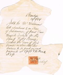
... OWEN WILLIAMS COLLECTION: VIEW HEIGHTS ESTATE LAND SALE...Document. The Owen Williams collection. Land Sale Note.... Document. The Owen Williams collection. Land Sale Note for View ...Document. The Owen Williams collection. Land Sale Note for View Heights Estate Bendigo. Sold to Mr Williams’s lot numbered 2 on plan of Subdivision of land View Heights Estate for the sum of fifty Pounds. Balance to be paid in equal payments at 03/06/99 and 12 months at 5%. It has a one penny orange duty stamp at the bottom with 19/08/99 and Mr Daley written on.bendigo, land sales, view heights estate, owen williams & co. -
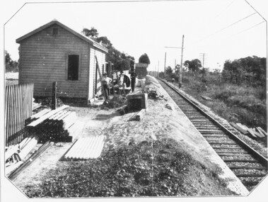 Ringwood and District Historical Society
Photograph, Constructing Ringwood East railway station - 1925
... plan land sale Ringwood East Railway Station Estate 1925?"... railway station. Sub-division plan land sale Ringwood East Railway ...Typed below one photograph, "Constructing Ringwood East railway station - 1925". Backing sheet of other photograph reads, "Ringwood East railway station - Higher than Croydon or Ringwood. Photo taken from Ringwood East railway station. Sub-division plan land sale Ringwood East Railway Station Estate 1925?"