Showing 568 items matching "land sales"
-
 Federation University Historical Collection
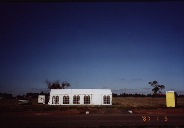
Photograph - Colour, Chatham-Holmes Collection: On the road to Burrumbeet, 1987, 1987
... land sales... on the road to Burrumbeat. Preparations for land sales.... on the road to Burrumbeat. Preparations for land sales. chatham-holmes ...Philip Chatham was responsible for the sub-division located on the road to Burrumbeat. Preparations for land sales.chatham-holmes collection, philip chatham, burrumbeat, land sales -
 Bendigo Historical Society Inc.
Document - LANDS OFFICE: SANDHURST LISTS OF ALLOTMENTS SOLD 1854 - 1856, 1854 - 1856
... land sales 1854... - 1856. Sandhurst land sales outlying districts 1854 -1861...land sales 1854 Lands office Sandhurst Bendigo Lands Office ...Document: LANDS OFFICE: SANDHURST LISTS OF ALLOTMENTS SOLD 1854 - 1856 Sandhurst lists of allotments sold, dated 1854 - 1856. Sandhurst land sales outlying districts 1854 -1861. Loose pages in plastic pockets, blue lined, formerly in register that has degraded and not repairable. Lists of date of sale, no. of lot, parish, allotment, section, extent (size) purchasers name.Lands Officeland sales 1854, lands office, sandhurst, bendigo -
 Bendigo Historical Society Inc.
Document - LANDS OFFICE: SALE OF CROWN LANDS
... Land sales... the number 16 and in black Land Sales 10-01-1934 to 31-12-1954...Land sales victoria crown land sales Bendigo central ...Hard cover journal, green cover with buff spine and edges. Sticker on the front: Sale register 1934-1954. On the spine in red the number 16 and in black Land Sales 10-01-1934 to 31-12-1954. Pages entered with details of sales by public auction of crown lands. LH page: lot, county, town or parish, allotment, section, area, survey fee paid, upset price per lot, sold for per lot. RH page: value of improvements if any, name of purchaser, address, purchase money paid, grant fees and assurance paid.land sales, victoria, crown land sales, bendigo, central and northern victoria -
 City of Moorabbin Historical Society (Operating the Box Cottage Museum)
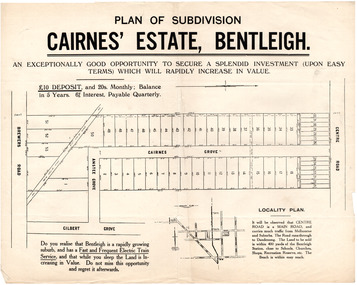
Flyer - Plan of subdivision for Cairnes' Estate, Bentleigh, mid 1920's
... land sales...Land sales in the Municipality of Moorabbin increased when... Cottage Museum) Joyce Park Jasper Road Ormond melbourne Land sales ...Land sales in the Municipality of Moorabbin increased when the train line from the City to Frankston was electrified.Example of the progress of the Municipality of MoorabbinExample of the progress of the Municipality of MoorabbinAdvertising flyer for auction of real estate sales - plan of building blocks for saleCairnes' Estate, Bentleigh 38 home sites and 14 business sitescentre road, cairnes grove, ansett grove, brewers road, bentleigh, land sales, real estate -
 Lakes Entrance Historical Society
Book, Morrissey D W and Morrissey E W, Lakes Entrance a Short History and Tourist Guide
... , including references to forest survey, land sales, shipping, fishing..., including references to forest survey, land sales, shipping, fishing..., including references to forest survey, land sales, shipping, fishing ...A short history of lakes Entrance from early settlement, including references to forest survey, land sales, shipping, fishing industry and development of the town and tourist industry A short history of lakes Entrance from early settlement, including references to forest survey, land sales, shipping, fishing industry and development of the town and tourist industrysettlers, land settlement -
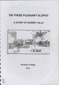 Surrey Hills Historical Society Collection
Book, On these pleasant slope's: a story of Surrey Hills, 2015
... Hills. Includes: First settlers, location, early land sales...: First settlers, location, early land sales, commerce and trade.... land sales, commerce and trade. freehold investment and banking ...Sourced via conversations with those interested in Surrey Hills History. Including Alan Holt, Jack McLean, Frank Bamford, Jocelyn Hall. Includes: Topographical maps, first Elgar Survey. First Wesleyan Church in Surrey Hills. Bibliography on P.50 (last numbered page) Provides a chronological history of Surrey Hills. Includes: First settlers, location, early land sales, commerce and trade.Provides a chronological history of Surrey Hills. Includes: First settlers, location, early land sales, commerce and trade.Back of Title page: To the Surrey Hills Historical / Arthur E. Tonkinfreehold investment and banking company, windsor park estate, (mr) dennis delany, mont albert village, surrey hills - history, royal hotel, surrey hills, humberstone's hotel, chatham state school, holy trinity church, lydswood, lugano, (mr) john butler maling, (mr) john hanlon knipe, mont albert primary school, (mr) james sneddon, (mr) arthur tonkin -
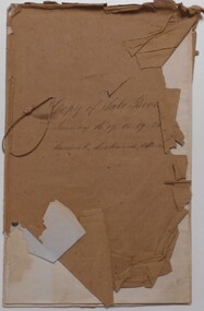
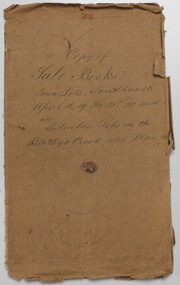 Bendigo Historical Society Inc.
Document - LANDS OFFICE: SANDHURST CROWN LAND SOLD BY AUCTION 1854
... land sales...Document: LANDS OFFICE: SANDHURST CROWN LAND SOLD...Lands Office Bendigo Sandhurst land sales Lands Office ...Document: LANDS OFFICE: SANDHURST CROWN LAND SOLD BY AUCTION 1854 booklet - brown paper cover with blue pages. On front cover ' copy of sale books, town lots Sandhurst, April 18,19,20,21, 22 and 24 also suburban lots on the Bendigo Creek sold May 10TH.? 1854' Booklet contains copies of advertisement for auctions, written alongside, name of purchaser and amount paid per acre. White sticker fixed to pocket ' Book 1, Sandhurst Land Sales, 10 May 1854 to 18 May 1854Lands Officelands office, bendigo, sandhurst, land sales -
 Bendigo Historical Society Inc.
Document - LANDS OFFICE: SANDHURST AND DISTRICT CROWN LAND SOLD BY AUCTION 1854
... land sales... to pocket: Book 4 Sandhurst Land Sales, including outlying areas 16... land sales auctions Document: booklet, brown paper cover ...Document: booklet, brown paper cover secured by string on spine. Written on front cover ' copy of sale books, January 16, 17. 18, 19, 26 1854. Harcourt, Lockwood, Muckleford' Blue lined pages with copy of advertisement for town lots for auction. LH page columns: price per acre, amount, deposit. RH page balance, purchaser, name, residence. White sticker fixed to pocket: Book 4 Sandhurst Land Sales, including outlying areas 16 January 1854 to 19 January 1854.lands office, bendigo, sandhurst, harcourt, muckleford, lockwood, land sales, auctions -
 Warrnambool and District Historical Society Inc.
Legal record - Warrnambool City Council
... land sales and sub-divisions... Council and contain information on land sales and sub-divisions... Council and contain information on land sales and sub-divisions ...These items are original records from the Warrnambool City Council and contain information on land sales and sub-divisions within the city area for the second half of the 20th century. The ledger contains the names of those involved in the sale and transfer of land and the file cards give illustrative details of the allotments – plans, maps etc. These items are of considerable significance as they are Warrnambool City Council records dealing with land sales and sub-divisions in the second half of the 20th century. They will be useful for research. .1 A metal-bound ledger with a dark red leather cover and pages printed with red and blue lines. There are red alphabetical tabs with gold print attached to the outer edges of the pages. The entries are handwritten in blue ink. .2 A grey metal cabinet, rectangular in shape and rusted on the base. The cabinet has two drawers with handles and these drawers contain file cards. The cards have a negative or transparency inserted into the top corner. .3 File cards with a negative inserted and a green backing .4 File cards similar to .3 above but of a different size. .5 A packet of unused file cards with tabs land sales and sub-divisions, warrnambool city council -
 City of Moorabbin Historical Society (Operating the Box Cottage Museum)
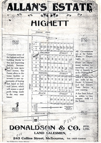
Flyer - Allan's Estate, Highett, 1922
... Allan's Estate, Highett land sales... Allan's Estate, Highett land sales Photo copy of advertising flyer ...The train line from the city to Frankston was electrified in 1922 which intensified the sale in the municipality of Moorabbin, particularly land which was in the vicinity of the railway stations.Example of the progress of the Municipality of MoorabbinPhoto copy of advertising flyer for auction of real estate sales - plan of building blocks for saleAllan's Estate, Highett land saleshighett road, baldwin street, harding street, allen street, highett, real estate, auctions -
 Bendigo Historical Society Inc.
Document - LANDS OFFICE, REPORTS OF SALES BY PUBLIC AUCTION, 1864 - 1892
... land sales.... on red rectangle ' Land sales by public auction' written in gold... land sales. Lands and Survey Dept. Document: buff leather hard ...Document: buff leather hard covered journal. On spine on red rectangle ' Land sales by public auction' written in gold. On bottom of spine 'Lands and Survey' written in gold on black. On base of spine '4' printed in black. Pages contain details of sales of crown lands by public auction Act 25, Victoria 145. Alphabetical index of counties inside front cover. 443 numbered pages. LH side columns, number, county, parish, section, allotment sold, unsold, price. RH page - improvements, purchaser, residence, amount, later sales have printed notices pasted in. Dated 27 April 1864 to 7 October 1892.Lands and Survey Dept.place, bendigo, sandhurst, crown land, public land auctions, land sales. -
Whitehorse Historical Society Inc.
Pamphlet, Blackburn Park, 1890
... Copy of land sales brochure for Blackburn Park.... of land sales brochure for Blackburn Park. Copy of land sales ...Copy of land sales brochure for Blackburn Park.Copy of land sales brochure for Blackburn Park.Copy of land sales brochure for Blackburn Park.freehold investment and banking company of australia ltd, morton, thomas richards burrowes, blackburn park -
 Bendigo Historical Society Inc.
Book - GALLAGHER COLLECTION: REAL ESTATE SALES W. MCKEAN & CO, 1930
... Book. Land sales. April 1930 to July 1937..... Land sales. April 1930 to July 1937. Book GALLAGHER COLLECTION ...Book. Land sales. April 1930 to July 1937. -
 Ringwood and District Historical Society
Photograph, At side of Ringwood State School looking along Greenwood Avenue, Ringwood, 1925
... Taken from (or used in) Bestpart Estates Land Sales...". Taken from (or used in) Bestpart Estates Land Sales Brochure ...Taken from (or used in) Bestpart Estates Land Sales Brochure, 1925Written on back of photograph, "At side of Ringwood State School looking along Greenwood Avenue". -
 Whitehorse Historical Society Inc.
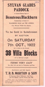
Document, Sylvan Glades Paddock Blackburn, C1922
... Brochure advertising land sales on corner of Blackburn Road... Brochure advertising land sales Brochure advertising land sales ...Brochure advertising land salesBrochure advertising land sales on corner of Blackburn Road and The Avenue, Blackburn.Brochure advertising land sales land subdivision, sylvan glades paddock blackburn, t. r. b. morton & son, orchid street, blackburn, heath street -
 Bacchus Marsh & District Historical Society
Map, Subdivision of the Manor House Property Bacchus Marsh c.1908
... Land Sales Bacchus Marsh...This land sales plan shows allotments of land offered...This land sales plan shows allotments of land offered ...This land sales plan shows allotments of land offered for sale in the inner township area of Bacchus Marsh in 1908. The land put up for sale was from the estate of the late Mr and Mrs J.E. Crook. That being James Elijah Crook and his wife Harriet, (nee Athorn). The Crooks had been resident in Bacchus Marsh since the 1840s and were prominent members of the community. They were prominent in the business, social and civic affairs of the town and district. In the 1850s the Crooks acquired the Manor House and nearby land once owned by the Bacchus family. James Crook died in 1889. When Harriet Crook died in February 1908 their estate was offered for sale. This included the large stone home known as the Manor House and various parcels of land including around 50 allotments of land near the Manor House, bounded by Young, Lerderderg, Crook and Main Streets. Most of these allotments of land were sold in October 1908. The Manor House itself was passed in at the sale and continued to be owned by the Crook family for several decades after 1908.A single page map on a single page of a bound volume of maps. The map shows portions of land for sale from the subdivision of the Manor House property in Bacchus Marsh in 1908. The names of most of the buyers of the portions of land have been hand-written into the various allotments they purchased. The maps are pasted into a bound volume containing 76 maps or plans in total. High resolution digital image stored on BMDHS computer network. bacchus marsh victoria maps, land sales bacchus marsh, manor house bacchus marsh, crook family bacchus marsh -
 Charlton Golden Grains Museum Inc
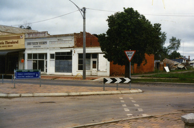
Photograph, West end Charlton High St c. 1987, c.1989
... Land Sales Agency, Hillier's Dr Cleaners and Manchester Unity... of High St.Eddie Harris Mensland, Mickinley's Land Sales Agency... Land Sales Agency, Hillier's Dr Cleaners and Manchester Unity ...Shops at the west end and on the south side of High St. Eddie Harris Mensland, and three small shops; Charles McKinley's Land Sales Agency, Hillier's Dr Cleaners and Manchester Unity. The three small shops were damaged by fire and demolished in the 1990s. Series of photos taken for use by the Charlton Shire.Colour photo of shops at the west end and on the south side of High St.Eddie Harris Mensland, Mickinley's Land Sales Agency, Hillier's Dr Cleaners and Manchester Unity. Sign on median strip pointing to Rotary Park, Public Conveniences, Electric Barbeque. Also a Give Way sign.eddie harris mensland, charles mckinley, hilliers, charlton, business, industry -
 Bacchus Marsh & District Historical Society
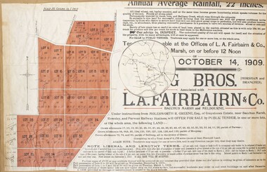
Map, Greystones Estate Land Sale 1909
... Land Sales... Maps Land Sales Land Sales Bacchus Marsh Greystones Estate ...This map was produced sometime around mid 1909 to advertise portions of land from the Greystones Estate for sale by public tender. The selling agents were Young Brothers of Horsham and L.A. Fairbairn of Bacchus Marsh and Melbourne. The seller was Molesworth R. Greene who was a pioneer pastoralist in the Bacchus Marsh area and had also acquired other properties in Victoria and interstate. Molesworth Greene died in 1916 so this sale came towards the end of his life. A total of 4,176 acres was offered for sale in multiple lots. Successful tenderers could buy single or multiple lots. The results of the sale were reported in the Bacchus Marsh Express newspaper on the 16th October 1909, page 3. At the sale a total of 3, 420 acres was sold. A single page paper map showing portions of land for sale from the Greystones Estate near Bacchus Marsh. The map includes extensive details about the property, number of allotments for sale, terms and conditions of the sale and prices. The map includes an inserted reference map showing the location of the property in relation to Melbourne, Geelong, Ballarat and Castlemaine. The top of the map appears to be missing resulting in some loss of the text. The sale notice in the Bacchus Marsh Express of 10 July, 1909, page 3, column 1 appears to duplicate the text overall in the auction plan. Based on this the missing text is likely to be: "Important Subdivisional Sale 'Of Portion of One of the Best and Most Favourably known Estates IN THE RENOWNED BACCHUS MARSH DISTRICT. And situated only six miles from that prosperous township, two miles from Rowsley, and three miles from Parwan, all Railway towns, connected with the Estate by metal roads." Scale: 20 chains to 1 inch The map is pasted into a bound volume containing 76 maps or plans in total. bacchus marsh victoria maps, land sales, land sales bacchus marsh, greystones estate bacchus marsh, molesworth r. green 1827-1916, land sales rowsley -
Glen Eira Historical Society
Document - GLEN HUNTLY (HISTORY OF)
... Land Sales... Caulfield Roads Board Elsternwick Land Sales Sugar Mills Koornang ...This file contains one item: 1/A loose-leaf, 23-page document titled ‘The History of Glen Huntly’, by Alfred R. Jones, dated 20/06/1991, describing the history of the suburb. The author has drawn heavily from the 4 sources noted in the bibliography. Subjects covered include the ship the suburb is named after, the suburb’s State School, the suburb’s churches, the Rosstown Railway and Sugar Mill, the origin of the name of Carnegie, the suburb’s aerodrome, and the beautification of the Glen Huntly Shopping Centre. The final 12 pages consist of 9 appendices relating to the aforementioned subjects. Appendix A is a typewritten letter from Ron McLeod, secretary of the Place Names Committee, to Mr. D. R. Aylen, CEO of the City of Caulfield, notifying the latter of the alteration of the name ‘Glenhuntly’ to ‘Glen Huntly’. Appendix B is a list of the ministers of St. David’s Uniting Church from its formation in 1916 to the present. Appendix C identifies the persons portrayed in St. David’s stained glass windows. Appendix D is a poster announcing the auction of 41 blocks of land between Hawthorn and Bambra Road formerly owned by William Ross, plus a map identifying said land blocks and anither fir locality. Appendix E is an A4 plan of the Rosstown Railway. Appendix F is a drawing of the Rosstown Sugar Mill. Appendix G is a poem titled ‘The Swagman’s Retreat’, by Herb Arnott, about the failure of the Mill. Appendix H is a map of Caulfield’s horse tramways plus a list of opening and closing dates. Appendix J is a list of streets explaining the meanings of their names.glen huntly, glenhuntly, local history, ‘glen huntly’ (ship), ‘glen huntlely’ (ship), quarantine stations, glen huntly road, lake street, mernda avenue, glen huntly state school no. 3703, ormond francis, ormond, garden avenue, grange road, churches, congregational church, glen huntly presbyterian church, st. david’s, st. david’s uniting church, anglican church, jenkin william ‘boss’, methodist church, wattle avenue, smith a. w. mr., glen huntly post office, glen huntly road, king f. l. mr., uniting church, child care centre, presbyterian church of eastern australia, glen huntly methodist church, sun aria, miller mary, stained glass, phrenologists, trinity congregational church, primitive methodists, ‘the victorian independent’, mercy mr., greek orthodox original old calendar church, wanalta road, salvation army, halls, myrtle street, catholic church, st. anthony’s roman catholic church, foundation stones, neerim road, mannix archbishop, st. agnes’ anglican church, booran road, sunday schools, clergy residences, ‘see’ anglican news magazine, lees archbishop, booth archbishop, glen huntly presbyterian church, el nido grove, tennis courts, bollard v. w. right rev., waratah avenue, royal avenue, munster avenue, james street, rothschild street, peace memorial organ, singers, bremner marie, scotland betty, carden joan, rosstown railway, south caulfield, plants, marata road, curraweena road, bambra road, ross william murray, ross leila, ross constance, vautin constance, ‘the grange’, north road, leila road, wild cherry road, caulfield roads board, elsternwick, land sales, sugar mills, koornang road, woornack road, elsternwick railway station, riddell parade, clarence street, dover street, oakleigh road, murrumbeena crescent, carlisle crescent, railways, trains, parks and reserves, caulfield council, sussex street, caulfield city council, swamps, rosstown sugar mill, rosstown estate, ‘the swagman’s retreat’, arnott herb, rosstown, carnegie, ‘ross’s folly’, carnegie andrew, rosstown hotel, dandenong road, rosstown road, rosstown plate horse race, caulfield racecourses, ames avenue, rosstown court, hostels, murrumbeena, cinemas, innovations (cabinetry film), films, music, pianos, manchester grove, safeway store, squash courts, airports, lord reserve, aeroplanes, air navigation act 1921, neville street, larkin sopwith aviation company of australasia, lyons street, morgan street, bookmakers, nightsoil, poultry, weatherboard buildings, glen huntly railway station, rosedale avenue, rifle clubs, scout groups, 1st glen huntly troop, ana, dowding jack mr., glen huntly infant welfare and family planning clinic, vermador private hospital, watson grove, rowlands (drapers), bones plant nursery, caulfield railway station, bridges, trams, horse tramways, glen eira road, elsternwick railway station, kooyong road, aboriginal peoples, truganini road, hannan lyn mrs. (urban planning officer), glen huntly shopping centre, sculptures, street beautification scheme, “flying the yellow flag”, moore olive, “return to rosstown”, jowett d. f., weickhardt i. s., “from sand swamp and health”, murray peter r., wells john c., caulfield historical society, newsletters, place names committee, mcleod ron, aylen d. r. mr., jones hugh rev., king joseph, scarfe james, vertigan sidney, vertigan earle, rance victor, flavell cameron, denholm robin, moorhead ken, taliai siupeli, eccles james leslie, little agnes, hutchins william r., dickie may a., gordon ivey agnes, theobald a. a. mrs., brownbill lloyd norman, ash georgette, land sales, auctions, messrs. crews & arkle, street names -
 Bendigo Historical Society Inc.
Document - LANDS OFFICE: CANCELLED R.A.'S FROM COSTERFIELD, SEYMOUR, BENDIGO, 1930 - 1950
... land sales... PLACE Bendigo land sales miners' rights Bendigo Sandhurst land ...Document: collection of individually tied files. Right to occupy residence area miners' rights. 1930's - 1950's. Includes Seymour, Costerfield, Bendigo. Heathcote, Cohuna, Trafalgar.Lands Officeplace, bendigo, land sales, miners' rights, bendigo, sandhurst, land sales, residence areas, costerfield, seymour, bendigo -
 Bendigo Historical Society Inc.
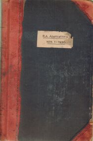
Document - LANDS OFFICE: R. A. APPLICATIONS NOS. 1 - 1930, 1936
... land sales... PLACE Bendigo land sales Bendigo Sandhurst land sales R.A ...Document: green hard cover journal with red spine and corners. On front cover ' R.A. Applications Nos. 1 - 1930' Residence areas - applicants for land Bendigo, Maldon, Castlemaine, Daylesford, Eaglehawk, Marong and district. 1936Lands Officeplace, bendigo, land sales, bendigo, sandhurst, land sales, r.a. applications -
 Bendigo Historical Society Inc.
Document - LANDS OFFICE REGISTER OF CROWN LANDS SOLD SANDHURST, 1855 - 1869
... Land sales...Land sales Lands Office land sales land surveyed Sandhurst ...Journal: black hard cover journal with buff spine and corners. Front cover badly damaged Written on spine ' S.I. Sales 1855 - 1869' '05' written in red ink on top of spine. On front cover 'G.W. Groves' written in blue ink under torn cover. Blue lined pages contain details of crown lands surveyed in district of Sandhurst, town, suburban and country. Details of parish, area, date of sale, price and name of purchaser. Indexed by parish on first page.Lands Officeland sales, lands office, land sales, land surveyed, sandhurst, bendigo -
 Bendigo Historical Society Inc.
Document - LANDS OFFICE - SALE OF CROWN LANDS - 1864 - 1869, 1864- 1869
... crown land sales... land, listed in chronological order of sales. Includes lot...Lands Office crown land crown land sales land sales Bendigo ...Journal: LANDS OFFICE - SALE OF CROWN LANDS - 1864 - 1869 Brown hard cover journal. Contains details of sales of crown land, listed in chronological order of sales. Includes lot, allotment, section, county, parish, area, upset price per acre, deposit, amount for which sold, valuation, name of purchaser. On spine 011Lands Officelands office, crown land, crown land sales, land sales, bendigo, sandhurst -
 Bacchus Marsh & District Historical Society
Map, Plan of Land at Bacchus Marsh, the Property of James Young, 1868
... Land Sales Bacchus Marsh..., and at the Border Inn'. One of the largest and most important land sales ...James Young was a prominent businessman, land owner and public figure in the early colonial period of Bacchus Marsh. In February 1868 he offered for sale through the agent W. Anderson 38 blocks of land which ran from the Lerderderg RIver westwards beyond Gisborne Road in the vicinity of the present day Masons Land. The land for sale was described as, 'unsurpassed Agricultural Land, in the immediate vicinity of Bacchus Marsh, varying in size from 2 to 12 acres each'. The sale notice in the Bacchus Marsh Express of 1st February 1868 page 2, also noted that, ' Plans can be seen at Mr. Young's Border Mills Store, and at the Border Inn'. One of the largest and most important land sales in the early colonial period of Bacchus Marsh.A single page paper map showing 38 blocks of land for sale in 1868 in the vicinity of Masons Lane Bacchus Marsh. Scale 11 chains to 1 inch. The map is pasted into a bound volume containing 76 maps or plans in total. High resolution digital image stored on BMDHS computer network. land sales bacchus marsh, bacchus marsh victoria maps, james young 1816-1871, masons lane bacchus marsh land sales -
 Bacchus Marsh & District Historical Society
Map, Bacchus Marsh Tuesday 23rd Oct. 1888, Lodge & Dunn's Paddocks 1888. Business and Mansion Sites
... Land Sales Bacchus Marsh... drainage'. Land Sales Bacchus Marsh Land Sales Maddingley Bacchus ...This map was created as a plan for an auction of land close to the Bacchus Marsh Railway Station. The auction took place on 23 October 1888. 102 allotments of land from an area known as Lodge and Dunn's paddocks was offered for sale. The auction was conducted by auctioneers based in Melbourne and was advertised in Melbourne newspapers as well as in the Bacchus Marsh Express newspaper. The auction plan contains a range of details including the selling agents, Munro and Baillieu; W.P. Lockhart; and John Turner, all of Melbourne, deposit terms for purchases, price of railway passes for a return trip from Melbourne to Bacchus Marsh of 1 shilling, and a description of the land as having 'magnificent views and perfect drainage'. A single page paper map showing allotments of land for sale along the Parwan Road in Maddingley. The map is pasted into a bound volume containing 76 maps or plans in total. High resolution digital image stored on BMDHS computer network. At bottom on left side: 'Harston & Co. Lith, Melb.'land sales bacchus marsh, land sales maddingley, bacchus marsh victoria maps, maddingley victoria maps -
 Bacchus Marsh & District Historical Society
Map, Bacchus Marsh Suburban Allotments Parwan Road Lodge & Dunn's Paddocks 1888
... Land Sales Bacchus Marsh... and Dunn's paddocks was offered for sale. Land Sales Bacchus Marsh ...This map was created as a plan for an auction of land close to the Bacchus Marsh Railway Station. The auction took place on 23 October 1888. 102 allotments of land from an area known as Lodge and Dunn's paddocks was offered for sale. A single page paper map showing allotments of land for sale along the Parwan Road in Maddingley. The map is pasted into a bound volume containing 76 maps or plans in total. High resolution digital image stored on BMDHS computer network. land sales bacchus marsh, land sales maddingley, bacchus marsh victoria maps, maddingley victoria maps -
 Bacchus Marsh & District Historical Society
Map, Nerowie Estate Land Sale 1910
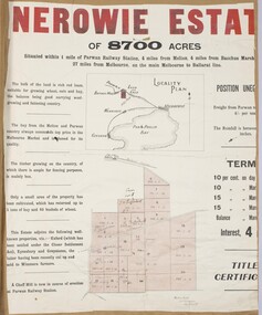
... Land Sales Parwan... Parwan Land Sales Parwan Land Sales Bacchus Marsh Staughton ...The Nerowie Estate was a large rural property of 8,700 acres (3520 hectares) near the locality of Parwan only a few kilometers east of Bacchus Marsh. It had once formed a large part of the land owned by the pioneering Staughton family.A single page paper map showing the land offered for sale from the Nerowie Estate at Parwan near Bacchus Marsh in 1910. The map is pasted into a bound volume containing 76 maps or plans in total. High resolution digital image stored on BMDHS computer network. nerowie estate parwan, land sales parwan, land sales bacchus marsh, staughton family bacchus marsh -
 Bacchus Marsh & District Historical Society
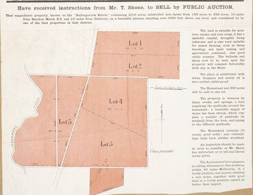
Map, Pentland Hills Estate Land Sale 1904
... Land Sales... Norton, jun at £11 per acre. Land Sales Pentland HIlls Maps ...The Pentland Hills Estate property shown in this auction plan was put up for sale in 1904. It was a deceased estate sale. The property had been owned by Peter Grant who died in 1899. Peter Grant had worked and farmed in the Myrniong area for many years and had also been a Councillor on the Bacchus Marsh Shire for a number of terms. A property sales report in the Express newspaper recorded that the land for sale comprised 500 acres of the old Pentland Hills Estate. It was subdivided into three lots, all of which were sold at good prices. Lot l, 212 acres was sold to Messrs Thomas and Robert Lidgett of Myrniong, at £11/15/ per acre, lot 2, 200 acres, to Mr David Robertson, of Bacchus Marsh, at £9 17/0 per acre, and lot 3, 38 acres, was sold to Mr James Norton, jun at £11 per acre. A single page paper map showing a portions of land available for sale from the Pentland Hills Estate near Bacchus Marsh.The name of the seller, Mrs Grant, can seen handwritten on this map and the buyers of the three portions for sale, Lidgett lot 1, Robertson lot 2 and Morton lot 3. Parts of the text are missing along the edges due to tearing or excessive trimming of the edges. The map is pasted into a bound volume containing 76 maps or plans in total. High resolution digital image stored on BMDHS computer network. Handwritten: Mrs Grant, Myrniong, Executrix in the deceased Estate of Mr. Peter Grant to sell by public auction.land sales, pentland hills maps, myrniong area land sales, pentland hills estate -
 Bacchus Marsh & District Historical Society
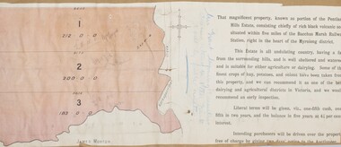
Map, Bullengarook Estate Property Sale. 1911
... Land Sales Bacchus Marsh... family. Land Sales Bacchus Marsh Bullengarook Land Sales ...Bullengarook is a locality located 19 kilometers north of Bacchus Marsh. Pastoral leases for European colonists were granted to people for this area from around the 1840s.The Bullengarook Estate was part of these early pastoral holdings. By the 1900s the property had been owned by the Skene family for a number of years. In early 1911 the property then consisting of 300 acres and the homestead upon it was offered for sale in one lot. It appears however that the sale of the property did not go through in 1911. It was later leased by Thomas Skene to a Mr Coutts in 1915 and ultimately and at a later stage the property was sold by the Skene family.A single page paper map showing land allotments for sale from the Bullengarook Estate. The map is pasted into a bound volume containing 76 maps or plans in total. High resolution digital image stored on BMDHS computer network. land sales bacchus marsh, bullengarook land sales, bullengarook estate, bullengarook vic history -
![Map, Plan of Subdivision of Crown Portion 23 & parts 24-25, Parish of Korkuperrimul [1900s?]](/media/collectors/5e461d8021ea67224c82f2a1/items/675fe058304668462205d4fb/item-media/675fe0ef304668462205d7d6/item-fit-380x285.jpg) Bacchus Marsh & District Historical Society
Bacchus Marsh & District Historical SocietyMap, Plan of Subdivision of Crown Portion 23 & parts 24-25, Parish of Korkuperrimul [1900s?]
... Land Sales Bacchus Marsh.... Land Sales Bacchus Marsh Bacchus Marsh Victoria Maps Land Sales ...The Parish of Korkuperrimul includes a significant section of the township of Bacchus Marsh and extends in western and northern directions from the township area. The date of the subdivision indicated on this plan has not been established. The engineer's stamp on the drawing shows the firm of Muntz and Muntz who were operating under that name in the early part of the 20th century.A single page paper map showing 20 blocks of land for sale in the Parish of Korkuperrimul. Scale 100 feet to 1 inch. The map is pasted into a bound volume containing 76 maps or plans in total. High resolution digital image stored on BMDHS computer network. Stamped: 'Muntz & Muntz Civil Engineers, Architects & Surveyors, Trustees Chambers ?? Cor Collins Street and Bank Placeland sales bacchus marsh, bacchus marsh victoria maps, land sales korkuperrimul parish