Showing 128 items
matching land settlement in victoria
-
 Sunbury Family History and Heritage Society Inc.
Photograph, September 1996
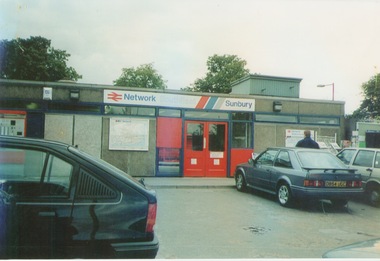
The photograph shows the railway station at Sunbury in Surrey in the United Kingdom. The town of Sunbury in Victoria was named after the English township of Sunbury-on-Thames in Middlesex by the Jackson Brothers who took up land in Sunbury, Victoria. The area was originally known as Koora Kooracup by the Wurundjeri people.Sunbury in Victoria like many other settlements in Australia were given names of towns in the United KingdomA coloured photograph of a railway station with three cars parked outside the building, which has grey walls and scarlet and blue trims. There are framed maps and notices on the exterior walls. -
 Port Fairy Historical Society Museum and Archives
Book, The Historical Committee Of Portland, The Portland Bay Settlement, 1934
Aboriginal resistance to settlement, Native Police Force, G.A. Robinsons proposal to re-settle Flinders Island people and extracts fom his 1841 expedition report. Contents I. The early navigators and explorers II. Sealers and whalers and tales of the sea III. The Hentys and Victoria's first permanent settlement IV. Early incidents and personalities V. Under government control Vi. Social life and activities VII. The story of the press VIII. Business, professions and industry IX. Hotels and roads X. Sport XI. Environs of Portland XII. Miscellaneous historical items.8vo; pp. x, 285; frontispiece, numerous b/w illustrations, plans and maps two of which are folding, index, appendices including "List of Purchasers at original land sale", "First Election List", "Subscription lists for both First Church of England and First Presbyterian Church", original blue cloth, title in gilt on spinenon-fictionAboriginal resistance to settlement, Native Police Force, G.A. Robinsons proposal to re-settle Flinders Island people and extracts fom his 1841 expedition report. Contents I. The early navigators and explorers II. Sealers and whalers and tales of the sea III. The Hentys and Victoria's first permanent settlement IV. Early incidents and personalities V. Under government control Vi. Social life and activities VII. The story of the press VIII. Business, professions and industry IX. Hotels and roads X. Sport XI. Environs of Portland XII. Miscellaneous historical items.robinson, george augustus, 1791-1866., government policy - initial period and protectionism - 1788-1850., government policy - state and territory - victoria., law enforcement - police - native police., race relations - violent - massacres, murders, poisonings etc. - to 1900., sport., pioneers -- victoria -- portland., portland (w vic sj54-11), portland (vic.) -- history., book -
 Port Fairy Historical Society Museum and Archives
Book, Richard Osburne, The history of Warrnambool, capital of the western ports of Victoria, from 1847 (when the first government land sales took place) up to the end of 1886, 1980
The history of Warrnambool, capital of the western ports of Victoria, from 1847 (when the first government land sales took place) up to the end of 1886 / by Richard Osburne Other Authors, Fraser, Malcolm, 1930-2015, (author of introduction, etc.) Tylee Memorial Collection368 pages, unnumbered and folded leaves of plates : illustrations (some colour), maps, portraits, plans ; 19 cmnon-fictionThe history of Warrnambool, capital of the western ports of Victoria, from 1847 (when the first government land sales took place) up to the end of 1886 / by Richard Osburne Other Authors, Fraser, Malcolm, 1930-2015, (author of introduction, etc.) Tylee Memorial Collectionvictoria. warrnambool, 1847-1886. facsimiles, government policy - initial period and protectionism., settlement and contacts - 19th century., mining industry - gold., race relations - violent - massacres, religions - christianity - missions., warrnambool (vic.) -- history., framlingham / purnim (w vic sj54-11), demography - census data, book -
 Melton City Libraries
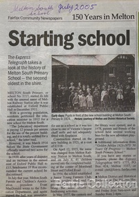
Newspaper, Melton Schools-150 years in Melton, 2005
Melton South "The establishment of a settlement of Melton South was induced by the opening of the railway in 1884. This subsequently prompted a number of industries, initially sawmills, and in the early twentieth century, chaff mills. This development coincided with the Exford ‘Closer Settlement’ estate at the beginning of the new century, boosting local population and produce, and the development of the chaff industry which employed many people in the Melton area. (Around 1912 the government had brought out English migrants to settle the Exford estate.) By c.1912 the small Melton Railway Station settlement had a boarding house (probably for chaff or sawmill employees), store, a small church and a hall. The Melton Valley Golf Club originated near the railway station in 1927 (in 1931 it moved to the present Melton links). In 1910 the community had built the large timber ‘Victoria Hall’, which became the focus of community life for several generations. In August of that same year AR Robertson MP and D McDonald applied for the establishment of a school on land set aside for that purpose by the Closer Settlement Board, near the Melton Railway Station settlement. District Inspector McRae recommended that a school for classes up to Grade 3 be established as an adjunct to the Melton State School. And so SS3717, ‘Melton Railway School’, was established in the leased Victoria Hall on 1st December 1911. Thomas Lang, head master at Melton since 1896, was in charge of both schools. As a ‘prep’ school only, it was necessary that the older Melton Railway Station settlement students travel to Melton SS430 at Unitt Street. Since 1912 local residents had been petitioning for the establishment of a separate school at Melton Railway Station on the grounds that it would be better if all children from the one home could attend the same school, and that the Victoria Hall was unsuitable as a school building. As a result an area of 2 acres - Allotment 8, Parish of Djerriwarrh, Exford Estate - was reserved for a State School on 4th March 1914. However the Department wrote that a school would not be established there in the near future, as ‘there is no likelihood in sight that the Railway Station settlement will increase in importance’. Parents persisted with their petitions to the Education Department, claiming that the Victoria Hall was too large, had no fireplace, that teachers were unable to use the wall for teaching aids, and that, being less than 20 metres away from a chaff mill employing 30 men, was too noisy. The turning point came when in 1920 the Hall Committee decided to increase its rent for the hall. In 1920 Head Teacher Lang advised the Education Department to discontinue SS3717 as an adjunct. The District Inspector supported this recommendation, and the schools separated in 1923. In April of that year 41 children, comprising Grades 1-8, moved into an almost completed brick building on the present site. On the 6th July 1923 the official opening of the school took place; after a ceremonial journey from the Hall to the school, speeches were given by the Hon AR Robertson and the Chief Inspector of Education. Everyone then journeyed back to Victoria Hall for a ‘bountiful repast’. (These dates are at odds with the date of 5th March 1925 given in Blake as the date the children occupied the new SS3717 brick school building. ) A teacher’s residence had been purchased for ₤500 in 1923, and the school’s name was changed to ‘Melton South’ in the same year. Even though the older Melton South pupils would no longer have to travel to the Unitt Street school, an additional brick room was still required at the Melton SS430 in that same year. In 1961 a new room was added to the school. In 1972, at the beginning of Melton’s boom as a satellite town, the number of enrolments was 224. The school has since shared in the exponential growth of the town of Melton, and at the time of its jubilee celebration (1983), 524 pupils were enrolled. Victoria Hall, neglected and vandalised, was demolished in 1992. It had been handed back to the Council on condition that it be replaced by a new hall, with the same name, and was commemorated by a plaque. Apart from the 1923 brick school building, and the railway station, none of the principal early Melton South public sites survive. Few early residential sites remain. (Further research will establish whether the house on the corner of Station Street and the railway line was the original teacher’s residence.)" Melton State School "On 17th May 1858 a State subsidised, combined Denominational School was opened by HT Stokes, with an attendance of about 30 children. This school was conducted in the wooden Melton Combined Protestant Church, situated on ‘a creek flat’ thought to be on the north side of Sherwin Street between Pyke and Byran Streets. It is likely that the Church had been established by 1855 and that the first minister was the Rev. Hampshire, who lived in Cambridge House on the Exford Estate. Ministers of the Protestant denominations were invited to hold services there. As there was only one resident Minister in the town (Presbyterian Mr J Lambie), laymen of the various denominations often spoke on Sundays. In 1863 this building was declared a Common School with the number 430. One of its first and most prominent headmasters was John Corr, who served from 1860 to 1864. Most of Mr Corr’s children also became teachers, including Joseph Corr, at the Rockbank school, and J Reford Corr and WS Corr, headmasters and teachers at numerous prestigious private secondary schools around Australia. John Corr purchased land alongside the school and elsewhere in and near Melton, became secretary and treasurer of the new Cemetery Trust, and by July 1861 was deputy registrar of births, deaths and marriages. He walked three miles every Sunday to teach at the Weslyan Sunday School he had established. Despite good reports from the Education Department Inspector, and burgeoning enrolments, the local school committee recommended the dismissal of, firstly, his wife (from the work mistress position), and then him from the headmaster position. Corr saw his dismissal as an attempt to redirect state aid for education from the Combined Protestant school to the support of the Free Presbyterian Minister Rev James Lambie (by one account the owner of the land on which the Common School was erected), whose son-in-law James Scott subsequently assumed responsibility for the school. Rev Lambie failed in his efforts to keep the existing school, which the Education Department Inspector and the majority of Melton citizens regarded as badly situated and badly built. Following a conditional promise of state aid, local contributors in 1868-69 raised ₤72.10.6 towards the cost of an iron-roofed bluestone rubble building 43 ft x 12 ft. This was erected on a new site of 1.5 acres (the present site). The State contributed ₤120 to the new school, which opened in 1870. A very early (c.1874) photograph of the school shows its headmaster and work mistress / assistant teacher (probably James Scott and his wife Jessie) and its (very young) scholars. Similar photos show pupils in front of the school in c.1903, and 1933. In 1877 a second bluestone room costing ₤297 was added and further land acquired from the Agricultural Society (who only needed it two days a year) to enlarge the schoolground to 3 acres. In the early 1880s an underground tank augmented the school water supply and in 1919 a five-roomed wooden residence was added. During this period the school correspondents often compained that the walls of the bluestone buildings were damp, affecting the plaster. In 1923 a brick room 26 ft 6 in by 24 ft with a fireplace and four rooms facing south, was added, and a corridor built to link the three buildings. This served adequately for the next 40 years. The school bell probably dates to 1883. The school also has a memorial gate (1951) to World War One ex-students, and an honour board to the 64 ex-students who served in the First World War. The school roll fell to 42 in the early post war-years, but was boosted by an influx of migrants, mainly from the UK, from the late 1960s. This presaged the boom in Melton’s development, and the corresponding growth of the school, with timber and temporary classrooms added to the previous masonry ones. An endowment pine plantation established in 1930 augmented the school’s fundraising activities when it was harvested in 1968. Part of the site was planted with eucalyptus trees in 1959. Famous ex-students of the early twentieth century included Hector Fraser (internationally successful shooter) and cyclist Sir Hubert Opperman". The Express Telegraph articles about the history of Melton South and Melton State Schoolseducation -
 Melton City Libraries
Pamphlet, Dry Stone Wall Driving Trail, Unknown
"The dry stone walls provide a tangible link to the area’s white settlement, and they remain a symbol of the profound change in land usage from the original Kulin custodians to the European arrivals of the nineteenth century. The bulk of dry stone wall construction in Victoria occurred between the 1850s and 1880s. The gold rush of the early 1850s in particular inspired a flurry of construction. At this time, labour previously available for shepherding livestock dried up, as men gravitated to the goldfields to seek their fortunes. This necessitated the building of fencing to contain the district’s growing number of sheep, cattle and horses. An explosion in surveying, subdivision and the sale of Crown lands also contributed to a boost in construction. Government regulations that punished pastoralists for allowing their livestock to stray provided further incentive to fence-off previously open expanses of land. The major benefit of this type of fencing was that it utilised the materials at hand; the plentiful grey basalt that scattered the landscape. In the case of the dry stone walls built around Melton, the characteristic round or oval shape of the volcanic fieldstones on the western plains inspired some distinctive designs.54 Another advantage of dry stone walls was their ability to withstand the ravages of flood, fire and drought often experienced in the district. This durability accounts for the fact that many of these fences still exist today". Dry Stone Wall trail brochure/pamphlet for visitors provided by Melton Visitor Information Centrecouncil, landscapes of significance -
 Wodonga & District Historical Society Inc
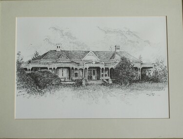
Drawing - Cambourne House, Kevin P. Clark, 1984
Cambourne homestead was built by 1903 for Rebecca S. Carkeek, who purchased the property in Wodonga in 1899. Cambourne is situated on the original Wodonga run which was established in 1836. The township of Belvoir, later renamed as Wodonga. In 1855 the pre-emptive right of 171 acres of the Wodonga run was granted and sold the following year. The allotments on which the five-acre Cambourne property developed, were purchased in 1873 and 1876, coinciding with the opening of the railway from Melbourne. The property was purchased by Rebecca Carkeek in June 1899, wife of William Carkeek, publican of Wodonga and shire councillor. Local architects Gordon and Gordon have been credited with the design of Cambourne. The house at Cambourne was built at some stage between 1900 and 1903 as a large single storey homestead. It was constructed in red brick with corrugated iron roof and encircling verandah. Cambourne is a probable work of architects Gordon and Gordon, it is amongst their best preserved and one of their few surviving buildings in Victoria. Today Cambourne remains on a reduced allotment due to the acquisition of land in 1972 by the Country Roads Board and in 2006 by Vic Roads for road works adjacent to the property.This drawing is significant as a representation of Cambourne in Wodonga. Cambourne is of historical significance due to its links with the early settlement of the district and as an example of closer settlement which occurred in regional centres of the State. Cambourne, Wodonga is also of architectural significance as a largely intact late Victorian style house with elaborate decorative cast iron work and distinctive transverse plan. As a probable work of architects Gordon and Gordon, it is amongst their best preserved and one of their few surviving buildings in Victoria. A framed drawing of historic home, Cambourne in Wodonga. The drawing has been mounted and framed.On bottom right corner" Kevin P. Clark 1984"cambourne wodonga, gordon and gordon architects, historic buildings wodonga, heritage buildings wodonga -
 Wodonga & District Historical Society Inc
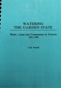
Book - Watering the Garden State - Water, Land and Community in Victoria 1834-1988, J.M. Powell
This publication traces the importance of water resources to Australian society, with reference to the state of Victoria. It relates the history from 1834 including topics such as community adaptation to settlement planning for squatters, miners, immigrants and colonials; conservation and water management; expansion and consolidation of statutory bodies following the creation of the Department of Water Resources in 1984; and finally the effects of regionalism, environmentalism, urban conflict and institutional reform. It includes an appendix containing a brief chronology of significant events regarding water from 1853 to 1987.Spiral bound booklet with laminated covernon-fiction This publication traces the importance of water resources to Australian society, with reference to the state of Victoria. It relates the history from 1834 including topics such as community adaptation to settlement planning for squatters, miners, immigrants and colonials; conservation and water management; expansion and consolidation of statutory bodies following the creation of the Department of Water Resources in 1984; and finally the effects of regionalism, environmentalism, urban conflict and institutional reform. It includes an appendix containing a brief chronology of significant events regarding water from 1853 to 1987.water resources development, water-supply -- victoria -- history., water victoria -
 Lakes Entrance Historical Society
Book, Alison Goding, This Bold Venture the story of Lake Tyers House Place and People, 1990
The story of Lake Tyers House, situated on Lake Tyers, Victoria, and the people associated with this early tourism venture. The settlement and development of the region is also dealt with and photographs are included.guesthouses, waterways, land settlement -
 Whitehorse Historical Society Inc.
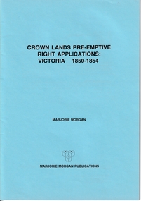
Administrative record - Crown Land Valuations and Applications, Government Printer - John FERRES, Crown Lands Pre-emptive Right Applications: Victoria 1850-1854, 1855
Contains a valuation for Crown Lands applications under pre-emptive right by Victorian county, giving names of applicants name of run, area, and remarks.Contains a valuation for Crown Lands applications under pre-emptive right by Victorian county, giving names of applicants name of run, area, and remarks. Contains a valuation for Crown Lands applications under pre-emptive right by Victorian county, giving names of applicants name of run, area, and remarks. clarke andrew, anglesey, evelyn, bourke, dalhousie, dundas, follett, grant, hampden, heytesbury, normanby, polwarth, ripon, talbot, villiers, district of murray, district of wimmera, district of western port, early settlement, mornington -
Port Melbourne Historical & Preservation Society
Booklet, State Government of Victoria, Making the Most of the Bay, 1990
Making the Most of the Bay - Plan for the protection and development of Port Phillip and Corio Bays, November 1990. An A4 booklet considering environment, land use and settlement, recreation and tourism, coastal and marine industries. Detailed recommedations for specific areas and foreward by Ministers Steve Crabb and Andrew McCutcheon (ref. item 1414, draft version)state government victoria, natural environment - conservation -
Lakes Entrance Historical Society
Book, Meridith Fletcher, Gippsland Heritage Journal, 1996
Life in various areas around Gippsland Victoriaagriculture, land settlement, migrants -
Lakes Entrance Historical Society
Book, Auer Valerie, Tubbut - Notes on History of Tubbut district - Prepared for School Jubilee 1941-1991, 1991
Notes on the settlement of Tubbut, East Gippsland, Victoria, particularly since 1929 when the Land Board opened this isolated area for selection. Extracts from minutes of Tubbut Hall Committee, reminiscences of school teachers, some photograph.settlers, schools -
Lakes Entrance Historical Society
Book, Fairweather, Keith Mc D, Brajerack - Mining at Omeo and Glen Wills
A Description of the mining industry in the northern part of of the Shire of Omeo, Victoria,dealing with the settlements of Omeo, Glen Wills, Sunnyside, Saltpetre Creek and Wombat, also Cobungra River and Newrush Creek. Aboriginal identities IllustratedRuth Clarkaboriginals, mines and mining, land settlement -
Lakes Entrance Historical Society
Book, Tract Consultants Australia Pty Ltd, Storth Ryes Enviornment Effects Statement, 1988
Environment effects statement, Supplementary Report on the proposed Storth Ryes, Metung, Victoria, residential and resort development on the Gippsland Lakes. Includes concept plans and sketches.land settlement, commercial development -
Lakes Entrance Historical Society
Book, Calder Stuart and Winty, East Cunninghame and Lake Tyers Beach. A case study Report, 1976
A case history of resort development in the Lake Tyers Beach Victoria coast area, considering the history of land use and future planning with regard to environmental impact and social requirements.natural history, land settlement -
 Lakes Entrance Historical Society
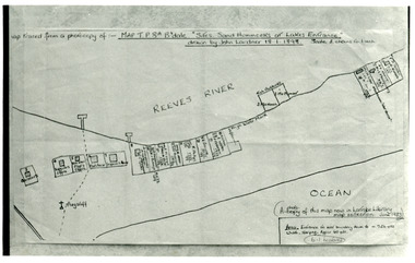
Photograph - New Works Plan, 1898
Map traced from a photocopy of :- Map TP8A Bairnsdale. 'Site. Sand Hummocks of Lakes Entrance'. Drawn by John Lardner 18 January 1898. Scale two chains to one inch. ( A photocopy of this map in Latrobe Library map collection, June 1983)Black and white photograph showing sketch map of 1898 by John Lardner Plan of Sites - sand hummocks. Drawing shows sites of buildings at entrance along Cunninghame Arm shoreline at Lakes Entrance, Victoria.land settlement, plan -
 Lakes Entrance Historical Society
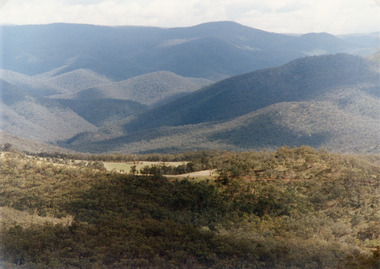
Photograph - Suggan Buggan, Tambo Shire, 1994 c
Also second identical copyColour photograph of the scenery in Suggan Buggan, showing very heavily forested mountainous country, a small area of cleared land centre left foreground. Suggan Buggan Victoriasettlement, agriculture, topography -
 Eltham District Historical Society Inc
Photograph - Digital Photograph, Alan King, St Margaret's Anglican Church, Pitt Street, Eltham, 30 January 2008
St Margaret’s Church of England was officially opened on December 12, 1861. It is the oldest intact church building in Eltham. At the time it was known as Christ Church until its consecration in 1871, when it was completely free of debt (£1,700 for the church and parsonage) despite the district’s poverty. This was largely due to the free labour and materials, including locally made bricks donated by local artisans and others. The church is historically significant because it is the oldest church in the former Shire of Eltham and has associations with the philanthropist and founder of Brighton, Henry Dendy (who donated the land on which the church is built), the architect Nathaniel Billing and the prominent local builder, George Stebbing. The church is architecturally and aesthetically significant because it is constructed in the Gothic Revival style with several stained-glass windows of various dates and is also a very early use of polychromatic brickwork in Victoria. Billing was one of the first Melbourne architects to employ polychromatic brickwork and an important early architect. The rear wall was intended to be temporary. A major feature of the design is the large buttresses with long, steeply graded upper faces. The overall design is well proportioned with the surface brick patterns relieving an otherwise austere design. The church is spiritually and socially significant because it has been an important place of worship for the people of Eltham for almost 150 years. The land on which the buildings stand was donated by Henry Dendy. Dendy arrived in Melbourne in 1841 after purchasing in England eight square miles at Brighton under the system of "special surveys". After this land passed out of his hands, Dendy moved about Victoria, visited England, then returned to settle in Eltham where he purchased a flour mill. Dendy chaired the meeting held in 1860 “for the purpose of devising such means as may be expedient for the establishment of a Church of England in the township of Eltham”. He became chairman and treasurer of the church committee. Unlike the establishment of many early churches in Victoria where a vicar was appointed to a parish and later a permanent church was constructed, the population at Eltham initiated action to build a church. The nearest church at that time was at Heidelberg and the Eltham settlement was part of the parish of St Johns Heidelberg. Isolation and the tedious, time consuming journey between Heidelberg and Eltham resulted in the Eltham community taking its own action. The original vicarage (Dendy House) at the rear of the church is also an important part of the cultural significance of this place because it is connected to the church and the development of the Eltham area. Together, the church and the vicarage are aesthetically significant because they form a significant streetscape feature. The mud-brick community hall designed by Robert Marshall was added in 1978. In 2014 the original temporary rear wall was removed as part of a modern extension designed by Architects Atelier Wagner and constructed by Conrad Construction and Management. Covered under Heritage Overlay, Nillumbik Planning Scheme. National Trust of Australia (Victoria) State significance Victorian Heritage Published: Nillumbik Now and Then / Marguerite Marshall 2008; photographs Alan King with Marguerite Marshall.; p67 St Margaret’s Anglican Church in Pitt Street, Eltham, which officially opened on December 12, 1861, is the oldest intact church building in Eltham.1 With the nearby courthouse and police station, it was one of the first permanent community buildings in the district. The church and vicarage are on the Register of the Heritage Council of Victoria and the National Trust of Australia – Victoria. The church is important as an early example of polychrome brickwork by the notable architect Nathaniel Billings. It is also notable for its historic associations with the early settlement of the Shire of Eltham and its connection with Henry Dendy, Brighton’s founder.2 Henry Dendy, who lived in Eltham much longer than at Brighton, chaired the original meeting which planned the church, and he donated the half-acre (0.2ha) site. Dendy had arrived in Melbourne in 1841 after buying eight square miles (20.7sq km) at Brighton while in England. After this land passed out of his hands, he eventually settled in Eltham where he bought a flour mill, west from the corner of Main Road and Pitt Street (then called Brewery Lane). The vicarage was named Dendy House after him. The Eltham settlers were unusual in initiating the establishment of a church. Usually in Victoria a vicar was appointed to a parish and then a permanent church was constructed. But then, the nearest church was at Heidelberg, which was a tedious and time-consuming journey. St Margaret’s builder was a local, George Stebbing, who also constructed the former Methodist, later Uniting, Church at John Street and the Shillinglaw Cottage near Eltham’s Central Park. It is believed the first Anglican Bishop of Melbourne, Bishop Perry, dedicated the church. After the ceremony he joined in the festivities at the nearby pub and a bill was sent to the parish for teas taken there by the bishop with other participants. The first vicar was the Reverend Robert Mackie from 1864 to1866. St Margaret’s Church was originally called Christ Church until its consecration in 1871, when it was completely free of debt (£1700 pounds for the church and parsonage) despite the district’s poverty. This was largely due to the free labour and materials, including local bricks, donated by local artisans and others. St Margaret’s Church is in the Gothic Revival tradition with a buttressed nave, paired lancet windows, porch and bell-cote. It was the first polychromatic brick church in Australia, using softly contrasting coloured brickwork.3 Billing was one of the first architects to introduce polychrome brickwork into Melbourne. His original drawings for St Margaret’s survive in a folio of his architectural work. However the church’s brickwork is more subdued than in his drawings. About half the windows – those in clear glass with gold borders – are original. The stained glass windows were made much later, but the one behind the altar is thought to be the oldest in the Diamond Valley. It was to be temporary until the congregation could afford to extend the church. In the early 1960s the original cedar pews were replaced by blonde timber pews and the originals were sold to restaurants and to private individuals. Eminent local sculptor Matcham Skipper created a crucifix for the church. A major addition was made in 1978, when the weatherboard hall was replaced by a mud-brick hall. Made of local material, it was designed by local architect and a former shire president Robert Marshall. The mud-brick hall reflects the style of building in Eltham of the late 1970s and for which Eltham is well-known. Perhaps because its earthy tones blend with the surrounding environment, the hall sits well with the church building. St Margaret’s membership has included economist and ABC chairman, Richard Downing; political commentator, diplomat and academic, William Macmahon Ball; Eltham civic leader, Charles Wingrove; artist, Peter Glass; and Eltham’s first postmaster, Frederick Falkiner.This collection of almost 130 photos about places and people within the Shire of Nillumbik, an urban and rural municipality in Melbourne's north, contributes to an understanding of the history of the Shire. Published in 2008 immediately prior to the Black Saturday bushfires of February 7, 2009, it documents sites that were impacted, and in some cases destroyed by the fires. It includes photographs taken especially for the publication, creating a unique time capsule representing the Shire in the early 21st century. It remains the most recent comprehenesive publication devoted to the Shire's history connecting local residents to the past. nillumbik now and then (marshall-king) collection, eltham, st margaret's anglican church, st margaret's church, st margarets church hall, christ church -
 Emerald Museum & Nobelius Heritage Park
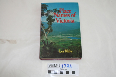
Book, Place Names of Victoria, 1977
The sequence of naming was a chronological representative of land discovery and settlement. Starting from the native population to the explorers, the squatters and settlers and surveyors during the gold rush. The term 'places' refers to physical features of the coast and land as well as districts, towns and cities.Hard Cover book written by Les Blake and first published in 1977. The jacket has a photograph of Mount Beauty and the Kiewa Valley from the Tawonga Gap.place names of victoria -
Lakes Entrance Historical Society
Book, Land Conservation Council, Victoria, East Gippsland Area Review Final Recommendations Land Conservation, 1986
Report describing the physical nature of the East Gippsland area (Victoria) study area. History, climate, geomorphology, land use, flora and fauna are presented. Map included.topography, land settlement -
Lakes Entrance Historical Society
Book, Colwell, Max, The Big Rivers' Murray, Darling, Murrumbidgee, 1978
The Murray-Darling basin river system - called the rivers of life. Victoria, New South Wales and South Australia. 32,000 Kms. along the system.waterways, catchments, natural disasters, bridges, commerce, land settlement -
Lakes Entrance Historical Society
Book, Regional Coordination Group and Strategy Steering Committee, The East Gippsland Planning and Development Strategy, 1997
An outline of planning and proposed development by the East Gippsland, Victoria, Shire Council from 1997 to the year 2010. Maps included.township, land settlement, tourism -
Lakes Entrance Historical Society
Book, Higgins, Julie, Yes, We Remember, 1976
Recollections of St. George's Church, Nowa Nowa, Victoria at 14th. March, 1976. Included are references to the settlers and development of Lake Tyers, Wairewa and Tostaree.land settlement, religion, township -
Lakes Entrance Historical Society
Book, Synan Peter, Secrets of Ghost Towns of the High Country featuring 50 Ghost Towns in and around Victorias Alpine Region, 1989
A history of the Gippsland Lakes Victoria as a transport system v for trade within the Lakes and River systems and coastal and interstate trade.ships and shipping, land settlement, waterways -
Lakes Entrance Historical Society
Book, Synan Peter, Highways of Water- How shipping on the Lakes shaped Gippsland, 1989
A history of the Gippsland Lakes Victoria as a transport system for trade with in the lakes and river systems, and coastal and interstate tradeships and shipping, land settlement, waterways -
Lakes Entrance Historical Society
Book, South Gippsland Development League, Land of the lyrebird, 1966
A story of early settlement in the great forest of South Gippsland including fauna hardships experienced by the early explorers and settlers and the settling and development of this once hostile and impenetrable part of Victoria. IllustratedRuth Clarkexplorers, settlers, fauna -
Lakes Entrance Historical Society
Book, Adams John, The Tambo Shire Centenary History, 1981
A history of the Shire of Tambo, East Gippsland, Victoria, including many aspects of settlement, development, industries, transport, and the hardy people who tamed this varied and often inhospitable region.A history of the Shire of Tambo, East Gippsland, Victoria, including many aspects of settlement, development, industries, transport, and the hardy people who tamed this varied and often inhospitable region.land settlement, transport -
Lakes Entrance Historical Society
Book, Bridges Roy, One Hundred Years 1884-1934, 1934
A comprehensive history of the Colony of the State of Victoria, covering the century from date of first settlement to 1934. Includes accounts of early settlers, squatters, founding of Melbourne the gold rush Federation and the effects of war time.Happy BIrthday to Dad with love from Ruthland settlement, exploration, government -
Lakes Entrance Historical Society
Book, Hannan, Kirsty, St Johns Church, Metung, Victoria, 2005
Research, interpretation land management recommendations for St. John's Church, Metung, Victoria, by Forestec Studentreligion, land settlement -
Lakes Entrance Historical Society
Book, Browne, Anastasia, Kleinitz Kipsy, 2003
Research, interpretation and management recommendations for the Kleinitz Kipsy, Nungurner, East Gippsland, Victoria by Forestec student.buildings, land settlement