Showing 285 items matching "landscape centre"
-
 Kiewa Valley Historical Society
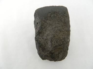
Axe Head, Before European settlement
This item was used well before European settlement and clearly demonstrates the development of the local Aboriginal tribes, Dhudhuroa and Yaitmathang in the use of a cutting /chopping implement, made from Mount William sourced material i.e. greenstone. This item was probably traded at the Bogong Mountain tribal yearly summer ceremoniesThe significance of this item places it at the fore front of human development in this region. The period when this tool was manufactured represents the time when the natural landscape had not been altered and the natural vegetation, fauna and flora, had not been subjected to imported species.This also proves that local tribes did live in this area and or the Bogong High Plains.Small ground edge stone axe head. Leading cutting edge very smooth and chiseled to a fine edge. Weight is, for its size fairly heavy. It is made from Greenstoneaboriginal tool stone ground-edge axe indigenous tool -
 Victoria Police Museum
Photograph (Victoria Police), Police Officers on dinner event, February 1945
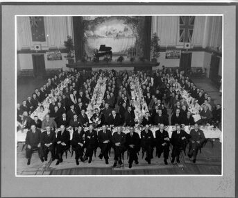
[see inscriptions] Black and white mounted photograph. Approximately 160 men (171 according to inscription on the back) sitting on large tables at a formal dinner event; all weatinh suits and posing for photograph. Photo was taken in a large rooom with a stage, Malvern Town Hall accoring to inscriptions on the back - tables occupy centre and front of photograph - but in the background: [left] Australia flag, WWII poster; [center] stage with painted landscape and piano; [right] WWII poster and Britain flag. [information of event on newspaper cutting stuck on the back - as described on Inscriptions]Handwritten: 171 PRESENT // FEB 1945 // (?) OFF SUPT KNOTT // INSPT SAMBLEBE // CONST GRAMBEU /// MALVERN TOWN HALL Newspaper cutting glued to frame: Supt. J. R. H. Knott, has rettired from the Police Force after 38 and half years' service, was farewelled by citizens and police officials at Malvern Town Hall on Tuesday night, The mayor of Malvern (Cr. J. Johnson) presided and presented SUpt. Knott with a chair and a wallet of notes. Similar presentations were made to Inspector C.H.D. Samblebe and First Constable O. Grambau, who have also retired. Supt. A.D. McKinnon of Ballarat will succeed Supt. Knott // handwritten: SUN 1/2/45victoria police museum, police officers, police academy, police force, superintendent mckinnon, superintendent knott, cr johnson, inspector samblebe, first constable grambau, poulter, william -
 Learmonth and District Historical Society Inc.
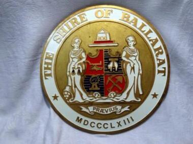
Shire of Ballarat Crest, Circa 1963
A very large version of this crest was on the outside of the former Shire of Ballarat building in Wendouree after the Council moved there from the original Shire Hall site in Learmonth.Official Logo/Crest of the Shire of Ballarat.Crest of the Shire of Ballarat,Circular in shape,with gold edging then a white band with the words THE SHIRE OF BALLARAT in gold paint at the top,a star on either side below this and at the base the date MDCCCLX111.In the centre, on a gold painted background is the Shire Crest which shows two figures(in white) each side of the crest which is in the shape of a shield,divided into four and shows at top left a "landscape" on red background,bottom right, on red,a spade and pick crossed.Top right on gold and blue stripe,is a sheep, in white outlined in gold, and bottom left, on blue and gold stripe,is a sheath of wheat in gold.Beneath this is the word PRAEVIUS on a "ribbon"decoration.THE SHIRE OF BALLARAT.PRAEVIUS.MDCCCLXIII.shire of ballarat.crest.shire of ballarat logo -
 Eltham District Historical Society Inc
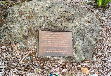
Photograph, Communal gravesite for stillborn babies or those who died soon after birth, Eltham cemetery, August 2007
A memorial to still born babies at Eltham cemetery lies under the trees on the west side. A plaque within a garden bed states: “Cherished, but not cradled. This small garden is adjacent to a communal gravesite for stillborn babies, or those who died soon after birth. They were all born and /or died at Queen Victoria Medical Centre and buried between March 1979 and April 1986.” The landscaping was funded by Stillborn and Neonatal death Support (SANDS) Vic. Members. It also initially had a low wooden seat in place. (No longer in place as of April 2022) The Queen Victoria Medical Centre itself was founded in 1896 and at the time was one of only three hospitals worldwide founded, managed and staffed by women. The Centre has since merged and amalgamated with the Monash Medical Centre. EDHS records indicate that the communal burial site was also fo bodies that were donated to science. Roll of 35mm colour negative film, 6 stripsKodak GC 400-9eltham cemetery, communal grave, stillborn, plaque, memorial plaque, memorial to still born babies, women in eltham cemetery tour -
 Eltham District Historical Society Inc
Photograph, Memorial to still born babies, Eltham cemetery, August 2007
A memorial to still born babies lies under the trees on the west side of Eltham cemetery, Mt Pleasant Road, Eltham. A plaque within a garden bed states: “Cherished, but not cradled. This small garden is adjacent to a communal gravesite for stillborn babies, or those who died soon after birth. They were all born and /or died at Queen Victoria Medical Centre and buried between March 1979 and April 1986.” The landscaping was funded by Stillborn and Neonatal death Support (SANDS) Vic. Members. It also initially had a low wooden seat in place. (No longer in place April 2022) The Queen Victoria Medical Centre itself was founded in 1896 and at the time was one of only three hospitals worldwide founded, managed and staffed by women. The Centre has since merged and amalgamated with the Monash Medical Centre. EDHS records also indicate that it was also a communal gravesite for bodies that were donated to science. Roll of 35mm colour negative film, 6 stripsKodak GC 400-9eltham cemetery, communal grave, stillborn, memorial to still born babies, women in eltham cemetery tour, memorial, garden, sands, stillborn and neonatal death support -
 Glen Eira Historical Society
Album - Album page, Glenfern, Inkerman Street, Circa 1972
This photograph is part of the Caulfield Historical Album 1972. This album was created in approximately 1972 as part of a project by the Caulfield Historical Society to assist in identifying buildings worthy of preservation. The album is related to a Survey the Caulfield Historical Society developed in collaboration with the National Trust of Australia (Victoria) and Caulfield City Council to identify historic buildings within the City of Caulfield that warranted the protection of a National Trust Classification. Principal photographer thought to be Trevor Hart, member of Caulfield Historical Society. Most photographs were taken between 1966-1972 with a small number of photographs being older and from unknown sources. All photographs are black and white except where stated, with 386 photographs over 198 pages.From Victorian Heritage Database citation for Glernfern H0136 https://vhd.heritagecouncil.vic.gov.au/places/57 (as at 23/10/2020) Glenfern was built on spacious grounds at the corner of Inkerman and Hotham Streets, East St Kilda in two main stages in 1857 and 1876. From 1876 to 1984 Glenfern had only two owners, including the well known Melbourne family of artists, the Boyds. The property was bequeathed to the National Trust of Australia (Victoria) in 1984 and has remained in their ownership. The original Glenfern allotment was bought by John Bakewell in 1856 and sold the following year to Francis McDonnell, a prominent Melbourne investor. By 1858, the house, rated as the most valuable in Caulfield, had been built on the site. Due to financial difficulties, McDonnell offered a number of properties for sale in 1860, including Glenfern. It was not sold at this stage, but subsequently mortgaged in 1862. In 1866 Thomas Watson purchased the property and lived there until 1876 when it was sold to Captain John T. T. Boyd and his wife, Lucy, founders of the Boyd dynasty of artists, musicians, writers and architects. The Boyd family, including twelve children, lived there until 1907, with Lucy Boyd retaining ownership after her husband's death in 1891. In 1907 the property was subdivided and the greatly reduced Glenfern portion was purchased by the Ostberg family, who lived there from 1915. In the latter years of Boyd family ownership and the Ostberg ownership, Glenfern had several tenants and was run as a school on two occasions. The Ostberg family occupancy continued until the death of Miss Amy Ostberg in 1984. From 1929 the property was listed as Glenfern Flats, necessitating various internal alterations over a period of time. The original two storey house, attributed to architect Charles Laing, was extended for the Boyd family in 1876, by architect M. Hennessy. This comprised the addition of a two storey wing to the south of the existing building. Stables were built in 1884 by the architects Smith and Johnson and other outbuildings, since removed, were recorded on the site. The gardens were developed from the establishment of the estate and remnants of early plantings, exotic trees in particular, are evident. Various additions and alterations were made to the house in the twentieth century and a separate block of flats was built on the southern boundary in c1964. Glenfern is a two storey picturesque Gothic house of stuccoed brick with steep, gabled slate roofs, elaborate bargeboards and chimneys of conjoined stacks set diagonally. The original, asymmetrically planned L-shaped house, containing the principal rooms and a rear wing, was designed with two main facades facing north and west. The north facade contains an unusual recessed pointed arch bay formed between twin chimney flues. Internally cedar joinery includes an unusual set of double doors between the drawing room and parlour, the centre pair of which fold back and then slide into the walls. Detailing of the 1876 additions copied that of the original house, including the bargeboards, chimneys and western verandah. Ownership of Glenfern passed to the National Trust of Australia (Victoria) in 1984 and in 2002 transformation of the property into a Centre for the Arts and Culture commenced. This began with the establishment of an Artist-in-residence programme, followed by the Glenfern Writers Centre. Restoration and renovation of the building has been undertaken concurrently with the establishment of this centre. How is it significant? Glenfern, East St Kilda is of architectural and historical significance to the State of Victoria. Why is it significant? Glenfern is of architectural significance as an unusually intact and rare example of the picturesque domestic Gothic Revival house in Victoria. Of particular note are the clustered chimneys, bargeboards and twin arched chimney flues and the folding/sliding cedar doors between the principal rooms. It is significant as an important work of the prominent Melbourne architect, Charles Laing. Glenfern is of historical significance for its connection with the distinguished Victorian Boyd family. It has been recorded in a painting by Emma Boyd, wife of Arthur, in 1885 and in print by writer, Martin Boyd in 1952. Glenfern is of historical significance due to its ownership by only two families from 1876; firstly the Boyds until 1907 and the Ostbergs until 1984. Of note is the resistance to redevelopment in the latter half of the twentieth century and the subsequent survival of the 1907 Glenfern estate.Page 98 of Photograph Album with two photographs (one square and one landscape) of views of Glenfern.Handwritten: "Glenfern" 417 Inkerman Street [top right] / 98 [bottom right]trevor hart, east st kilda, garden, pitched roof, glenfern, hotham street, boyd family, 1850's, 1860's, 1870's, john bakewell, francis mcdonnell, thomas watson, lucy boyd, glenfern flats, charles laing, m. hennessy, smith and johnson, stables, gothic, stuccoed brick, gabled slate roofs, elaborate bargeboards, asymmetrical, cedar joinery, verandah, national trust of australia, centre for the arts and culture, artist-in-residence, glenfern writers centre, gothic revival, clustered chimneys, emma boyd, inkerman street, north caulfield, captain john boyd, artists, writers, st kilda east, national trust of australia (victoria), caulfield, amy ostberg, architects, m hennessy, doors, chimneys, martin boyd, arthur boyd, ostberg family -
 Glen Eira Historical Society
Article - Murrumbeena Park
This file contains three items. An article from THE AGE by Christopher Bantick, who reminisces on the facilities of Murrumbeena Park in decades past, and reflections on the changes the park has undergone in more recent times, dated 24/05/2008. Four coloured postcards of Murrumbeena Park displaying the flora, paths, play equipment, and facilities, taken by Margie McKenzie Photography, date unknown. An article from the CAULFIELD CONTACT listing the improvements that have and will be made to Murrumbeena Park, including a list of the facilities that are on offer as well as the sporting clubs that make use of the park, dated March 1992.murrumbeena park, murrumbeena, caulfield, parks, reserves, playgrounds, playground equipment, sports equipment, recreation equipment, children’s playground, gardens, sports grounds, playing fields, plants, kangaroo road murrumbeena, trees, sports establishments, recreations establishments, seesaws, slides, swings, monkey bars, murrumbeena park committee of management, murrumbeena cricket club, murrumbeena football club, clubs, associations, sporting clubs, barbeques, picnics, caulfield council, social facilities, murrumbeena park bowls club, oakdale angling club, landscape concept plan, caulfield city hall, caulfield town hall, municipal offices, official buildings, civic centres, local government, council chambers, walking trails, the age, caulfield contact -
 Glen Eira Historical Society
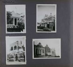
Album - Album page, Glen Huntly Road, Circa 1972
This photograph is part of the Caulfield Historical Album 1972. This album was created in approximately 1972 as part of a project by the Caulfield Historical Society to assist in identifying buildings worthy of preservation. The album is related to a Survey the Caulfield Historical Society developed in collaboration with the National Trust of Australia (Victoria) and Caulfield City Council to identify historic buildings within the City of Caulfield that warranted the protection of a National Trust Classification. Principal photographer thought to be Trevor Hart, member of Caulfield Historical Society. Most photographs were taken between 1966-1972 with a small number of photographs being older and from unknown sources. All photographs are black and white except where stated, with 386 photographs over 198 pages. From: Glen Eira Heritage Management Plan (1996) by Andrew Ward and Associates Moore's Buildings", were built in 1891 and comprising 5 shops. In 1888, Hugh Moore, a gentleman, subdivided his land in Glen Huntly Road, north side between Selwyn Street and St Georges Road into 27 lots, with a right of way separating them from his property "Glenmoore". The subdivision was known as the "Glenmoore Estate". Purchases of land included local builders Corkill, French and Pugh. Moore retained five lots and W.W. Jamieson bought lots 11 to 14. "Moore' s Buildings are locally important for their association with the early Elsternwick land owner, Hugh Moore, whose home, "Glenmoore", at 1 St.Georges Road (qv) survives. They recall Elsternwick's role in the Land Boom and survive as a most prominent row in the Glen Huntly Road shops, enhanced by the survival of the unpainted stuccoed surfaces to nos. 307-311. 287-289 Glen Huntly Road: contributory to HO72, Elsternwick Estate and Environs, City of Glen Eira.Page 63 of Photograph Album with one landscape photograph of retail shops (Moore's Buildings).Hand written: 287-289 Glen Huntly Road [under photo] / 63 [bottom left] trevor hart, shop, grocer, stuccoed, terrace, victorian terrace, protruding parapet, ornate render, hugh moore, 1890's, moore's buildings, glenmoore, glenmoore estate, shopping centres, milk bars, cars, victorian style, glen huntly road, glenhuntly road, elsternwick -
 Glen Eira Historical Society
Album - Album page, Glen Huntly Road, Circa 1972
This photograph is part of the Caulfield Historical Album 1972. This album was created in approximately 1972 as part of a project by the Caulfield Historical Society to assist in identifying buildings worthy of preservation. The album is related to a Survey the Caulfield Historical Society developed in collaboration with the National Trust of Australia (Victoria) and Caulfield City Council to identify historic buildings within the City of Caulfield that warranted the protection of a National Trust Classification. Principal photographer thought to be Trevor Hart, member of Caulfield Historical Society. Most photographs were taken between 1966-1972 with a small number of photographs being older and from unknown sources. All photographs are black and white except where stated, with 386 photographs over 198 pages. The Former Elsternwick Post Office is on the Victorian Heritage Register H0640 with a full significance statement and also HO29 with the City of Glen Eira. Much of the Glen Huntly Road heritage retail strip is heritage listed in HO72 with the City of Glen Eira.Page 67 of Photograph Album with four photographs (three portrait and one landscape) of different properties on Glen Huntly Road - a house, Post Office, ANZ Bank and shops.Hand written: Glen Huntly Road [top left] / 1027 GLEN HUNTLY RD [under top left photo] / ELSTERNWICK POST OFFICE [under top right photo] / 67 [bottom left] trevor hart, glen huntly road, elsternwick, shops, caulfield, post offices, glenhuntly road, banks, brick houses, shopping centres -
 Glen Eira Historical Society
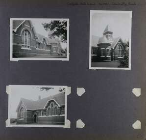
Album - Album page, Caulfield State School, No 773, Glen Huntly Road, Circa 1972
This photograph is part of the Caulfield Historical Album 1972. This album was created in approximately 1972 as part of a project by the Caulfield Historical Society to assist in identifying buildings worthy of preservation. The album is related to a Survey the Caulfield Historical Society developed in collaboration with the National Trust of Australia (Victoria) and Caulfield City Council to identify historic buildings within the City of Caulfield that warranted the protection of a National Trust Classification. Principal photographer thought to be Trevor Hart, member of Caulfield Historical Society. Most photographs were taken between 1966-1972 with a small number of photographs being older and from unknown sources. All photographs are black and white except where stated, with 386 photographs over 198 pages.From: Glen Eira Heritage Management Plan (1996) by Andrew Ward and Associates Caulfield State School No. 773 is important at the State level as the first of similar designs for small schools prepared by the Education Department under H.R. Bastow at Little Bendigo (1878), Glen Waverley (1880), Ascot (1882), Sandringham (1885) and Carlsrich (1892)·. It is a representative example of the Department's Gothic Revival designs, distinguished, however, by the semicircular treatment of the master's office, which compares with Portland (1879), Queensberry St Carlton (1880) and Footscray (1881). It has local significance as the earliest surviving Government School in Caulfield and as a centre for education from 1877, comparing with St. Mary's Jubilee School (qv) of 1887. The Caulfield State School of 1877, the horse tramway of 1889 and subsequently the electric trams were all events confirming the importance of Glenhuntly Road and the fledgling community of "Camden Town" wherein the City's commercial centre has its origins.Page 68 of Photograph Album with three exterior photographs (two portrait and one landscape) of one side of Caulfield State School with a fourth photo missing from the page.Hand written: Caulfield State School No. 773 Glenhuntly Road [top right] / 68 [bottom right] trevor hart, glen huntly road, caulfield state school, caulfield primary school, gothic revival, schools, caulfield south, arched window, tower, 1870's, camden town, red brick, curved windows, terracotta tiles, master's office, education, primary school, glenhuntly road, h r bastow -
 Federation University Historical Collection
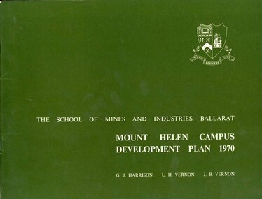
Book, Mount Helen campus Development Plan 1970, 1970
Green and white soft covered booklet of 48 pages. SMB Crest is on the front cover. The content include the Mt Helen site, site planning, student residences, sporting facilities, roads and parking, pedestrian circulation, engineering services, and landscaping. Illustrations include: Plan of Mt Helen Site (July 1969, existing buildings, Functional relationship, Roads and Parking, Pedestrian Circulation, engineering Services, Landscaping, Development Plan, Plan of Academic area, Library and union Courtyards, Birds Eye View of Academic Area from north-west, etc. the master plan projects student numbers.non-fictionuniversity of ballarat, ballarat institute of advanced education, mount helen, master plan, landscape, harrison, vernon, great hall, geoff harrison, john vernon, m.b. john, contour map, student accomodation, landscaping, development plan, campus plan -
 Federation University Historical Collection
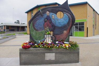
Photograph - Photograph - Colour, Churchill Service Memorial, 2015, 2015
In recognition of its fallen soldiers and Churchill's 50th birthday a service memorial was erected on a concrete plinth at the Churchill town plaza and used for the first time to mark the ANZAC centenary on Anzac Day 2015. Churchill never had a war memorial and received a grant from the Department of Veterans' Affairs six years ago to commission a sculpture with Latrobe City Council's support. It was decided the sculpture needed to recognise more than just the war effort, but service and volunteerism, considering Churchill was only founded in 1965. (http://www.latrobevalleyexpress.com.au/story/2816903/churchills-new-memorial/, accessed 01 may 2015) Sculptor Paul Jesse discussed the work in Churchill and District Community news, 18 December 2014: Some time ago CDCA commissioned a sculpture to be used as a Service Memorial to commemorate the fallen that have died in service of our community and country. Traditional memorials usually commemorate Armed Services personnel, but CDCA was of the opinion that a more inclusive view which included Emergency Services personnel, such as CFA, SES and Police, could be incorporated into the Churchill Memorial. Boolarra artist, Paul Jesse, who is accomplished in Ferro-Cement sculpture techniques, was commissioned to create a memorial that would cause people to reflect on the meaning of ‘service’ and ‘sacrifice’. The following is a description of the Churchill Service Memorial Sculpture written by the sculptor, Paul Jesse. “My sculpture is different from most War Memorial sculptures because it uses as its basis the reasons why people go into service or to war. One side of the sculpture is colourful and optimistic; its theme is home, family, community and the future. These themes are crafted by flow lines which are connected to the other side of the sculpture through the round hole and the Crosspiece. These lines can be seen as a multi-layered connection between the sides. On the “dark” side of the sculpture, the lines begin with a spiral of coloured mosaics. This spiral is representative of our service people. Its beginning can be seen on one level as their soul. The spiralling mosaics of them flow to the other side of the sculpture where they create the landscape and figures. These lines can also be seen as a range of connectors between the two sides, representing a flow of thoughts, love, fear, concern and dreams. They also represent physical communication such as letters and phone calls.” This ‘Service Memorial’ is located in the Churchill Plaza (adjacent to the Town Hall), along with four flagpoles, seating and garden beds. The Churchill Service Memorial has deliberately been designed as a thought-provoking public art work. It will complement the Art and Culture Pathway which links Switchback Gallery at the Federation University Campus to the Town Centre. We hope Churchill citizens will pause to view the Memorial, ponder its meaning, reflect on the service of others and commemorate the fallen. Colour photograph on an abstract Australia-shaped sculpture by Boolarra artist Paul Jesse. The abstract Australia-shaped sculpture is in stark contrast to the bronze-cast "fallen mate" or concrete cenotaph seen in many country towns. The photograph includes wreaths from the ANZAC centenary service on ANZAC Day 2015. churchill, churchill war memorial, paul jessie, anzac centenary, federation university, gippsland, art and culture pathway, world war -
 Federation University Historical Collection
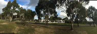
Photograph - Colour Photograph, Clare Gervasoni, Ballarat Technology Park, 2015, 13/08/2015
Colour photographs of buildings and landscape associated with the Federation University Technology Park.ballarat technology park, federation university technology park, state revenue office, ibm, canadian wetlands, berry street, ibm-issc-southern data centre plaque, roger hallam, geoffrey blainey, david james, global innovation centre, cic, greenhill -
Federation University Historical Collection
Newsletter, Genesis: The Dynamics of the Developing Campus Ballarat Institute of Advanced Education Mount Helen, 1971, 07/1971
Two photocopies of July 1971 edition of 'Genesis'.mount helen campus, wendouree charitable fund, timken international fund of canton, ohio, e.j. barker, student housing, student residences, student housing precinct stage 1, e.j. barker library, buildings, applied science building, student union building, wlaker and jackson, history of the mount helen site, l.h. vernon and associates, r.n. and j.e. greenbank, landscape, australian natives association, ballarat institute of advanced education, computer centre, i.c.l. 1901a computer system, chemistry acquisitions, metallurgy acquisitions, physics acqiusitions, electrical engineering acquisitions, mechanical engineering acquisitions, centenary appeal, new courses -
 Ringwood and District Historical Society
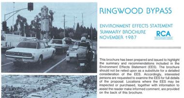
Newsletter, Ringwood Bypass Environment Effects Statement Summary Brochure - November 1987
8-page A4 size brochure issued by Road Construction Authority reporting on the proposed Ringwood Bypass. Topics include Community Consultation, Estimated Capital Costs, Traffic Effects, Property Effects, Mullum Mullum Creek, Landscape Development, Pedestrian/Bicycle Access, Noise, Air Quality, Compatability with Ringwood District Centre Development, Vehicle & Traffic Aspects, Lighting, Construction Impacts, Extension to Canterbury Road, Public Transport. -
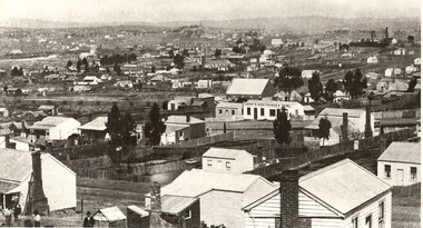
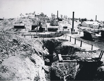
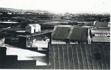
 Bendigo Historical Society Inc.
Photograph - VIEW OF MINER'S COTTAGES WITH KNIPES CASTLE IN BACKGROUND
Black and white photograph. Landscape view overlooking many weatherboard miner's cottages, brick house and more substantial buildings in background. Knipes Castle in background R. Mine with chimney and poppet legs in centre middle distance. Chimney at far R centre. Inscriptions: on back - 'MP 216', 'Historical Society of Victoria, Bendigo Branch'.place -
 Bendigo Historical Society Inc.
Photograph - VIEW OF MINING AREA - VICTORIA HILL
Black and white photograph. View overlooking north from Victoria Hill, mullock heaps, houses - some mid to late 20th century and some miner's cottages, formed road, children's playground centre foreground. Inscriptions: on back - purple rubber stamp 'Robert Wallace Studios, 6 Ruth Street, Golden Square, Phone Bgo 37565.Robert Wallaceplace, mining site, victoria hill, bendigo, mines and mining, landscape, mining landscape, mullock heaps -
 Bendigo Historical Society Inc.
Photograph - NEW CHUM GULLY C 1875, C 1875
Back and white photograph: panorama showing timber and brick residences, hotel, church ? Mines with poppet heads and chimneys in background. An image on building at centre ' Cleary's Honeysuckle Hotel' Ken Arnold captions this image ' New Chum Gully from Specimen Hill C 1875, photographer Caire 'Caireplace, landscape view, new chum gully, bendigo, cityscape, sandhurst, panorama, mining town -
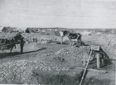 Bendigo Historical Society Inc.
Photograph - MINING LANDSCAPE, 1861
black and white photograph of mining area. Tents and slab buildings in background. Man with horse at puddling machine, water pipe in right and centre. Man with horse waiting at left.batchelderplace, landscape view, mining -
 Bendigo Historical Society Inc.
Photograph - MINING LANDSCAPE, 1861
black and white photo: alluvial diggings in foreground, wheelbarrow, centre field stone building with galvanised iron roof with chimney at rear. 2 stascks of 6 foot timber for boiler. Headframe in front. Man standing under shelter near head frame. Midground, left tank of vertical plants. Hill with 5 whims to rear. A. frame and timber structure at centre left, mullock dumps.batchelderplace, landscape view, mining -
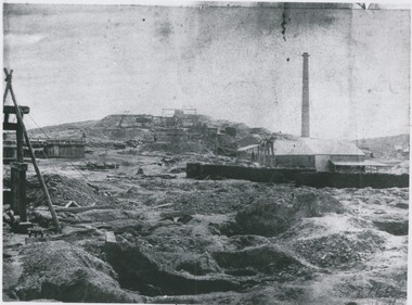
 Bendigo Historical Society Inc.
Photograph - VICTORIA HILL, 1860's ?
Black and white photo - mines and mining. At centre front - deep trench. At centre shed, poppet legs, wood pile, building with chimney at right. Wood pile, Building with chimney at back. At back, poppet legs on horizon, trees, building ( house ) buildings with chimney, trees, behind trees large 2 storey building ( Gold Mines Hotel ? ) other large buildings on horizon to right. ' Mining - Bendigo Vic. View of Victoria Hill taken from Old Chum Hill' written on back of photo.place, landscape view, victoria hill -
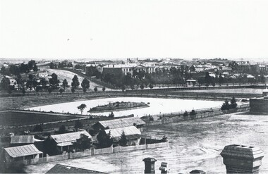 Bendigo Historical Society Inc.
Photograph - LANDSCAPE VIEW OF BENDIGO
Black and white photograph. In foreground, roof and chimneys. Row of 3 small weatherboard houses with verandah, picket fences. 1 small and 1 larger building behind. Lake or dam with small island centre, stone brick wall with lookout tower at corner ( Bendigo gaol ) at right centre distanc,e large building. Benevolent Asylum. Many other buildings in distance. James Lerk 11.2.2000 ' view from the Corporate High School, Benevolent Asylum in centre' Unknown BHS member 5.11.1999 ' lower dam ( site of present tennis courts, Park Road, pumped out C 1926' Written on back of photo 'Bendigo Victoria 1860's, Sandhurst North view 100 miles north from Melbourne. C. Nettleton, Victorian Views'C. Nettleton ?place, landscape view, bendigo -
 Bendigo Historical Society Inc.
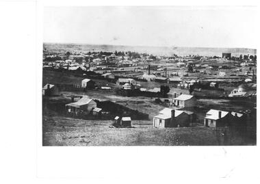
Photograph - BENDIGO LANDSCAPE: LOOKING SOUTHWEST 1856, C 1856 ?
Black and white photograph of mines at Bendigo. 'Bendigo Tin' on side of building, 'Hay and corn store' at rear. Poppet heads and dams visible. In foreground - larger buildings, mostly weatherboard with corrugated iron or zinc rooves. Left centre appears to be stable with loft doors. Middle distance - many buildings with heaps of dirt/rock. Far distance - many small buildings ( houses ) chimneys, trees hills. James Lerk 11.2.2000 ' C 1856 looking southwest , Forest St. ( tin smith ) going to the right.place, landscape view, bendigo mining -
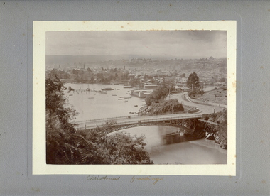 Bendigo Historical Society Inc.
Photograph - VIEW OF LAUNCESTON FROM CATARACT GORGE, c.early 1900's
Sepia photo on grey mount of elevated view of river with single span bridge, with boats moored. Swimming baths in centre to right. Town with church spires and houses and hills in background. Inscriptions 'Christmas Greetings' gold ink underneath photo. On back - written in pencil 'City of Launceston, Tasmania from Cataract Gorge'.W Vincent Kelly, Mitchell St., Bendigoplace, landscape view, launceston, tasmania -
 Bendigo Historical Society Inc.
Photograph - AGRICULTURAL SCENE, 1960-70's
Black and white photo: Landscape view of farming land, with large dead tree in centre foreground. Sheep are grazing in paddocks, stand of eucalypts in background of photo. Picture was exhibited in Bendigo Agricultural Show, 1974. Photo is accompanied by First Prize Certificate, Bendigo Show 1974.F. T. Kennedyplace, landscape view, agricultural -
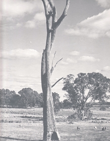
 Bendigo Historical Society Inc.
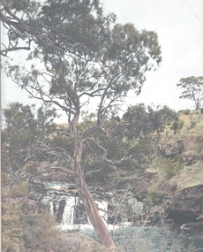
Photograph - WATER FALL - BARFOLD GORGE ?, 1960's ?
Hand tinted print: Gorge, with water running over a small waterfall. Large eucalypt centre of print. Local watercourse - Barfold gorge ? F.T. Kennedy printed on bottom right of photo mount.F.T. Kennedyplace, landscape view, waterfall -
 Bendigo Historical Society Inc.
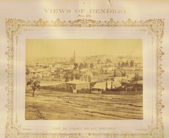
Photograph - VIEWS OF BENDIGO: GOLDEN SQUARE TOWNSHIP, c. 1870's
Photograph No. 19. Sepia photograph of view of Golden Square township. Church in centre back of view. Printed below photograph: Welch Type, Forbes & Holmes, Agents. Written on front MP148 (Two Copies) Nicholas CaireN J Caireplace, landscape view, golden square -
 Bendigo Historical Society Inc.
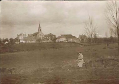
Photograph - ROBERT DENIS KELLY COLLECTION: LANDSCAPE VIEW BIESMES
Black and white photo: landscape view of Biesmes. Church spire in centre of town. Lady in foreground.person, robert denis kelly, world war 1, robert denis kelly collection. france, biesmes -
Bendigo Historical Society Inc.
Photograph - FORTUNA COLLECTION: FORTUNA, c1920s
Black and white photo. The hall at Fortuna Villa. Bottom left of a fire place with plants and deer sitting in it, on either end of the mantle are statues of ladies sitting reading, in the centre is a man holding up a disc shaped object. Along the wall there are a number of paintings one is of Sir George Lansell, others are landscapes. Also along the wall standing on the floor is a collectors cabinet on beautifully carved legs. A lady crouched down with an elbow on her knee, she is sitting on a pedestal. On the right of that is a cabinet is what appears to be a kerosene lantern then a Fire place screen. Markings/Inscriptions: Bartlett Bros. Bendigo. Sticky label on front centre bottom; 338 ST 83buildings, residential, fortuna villa, bartlett bros. bendigo -
Bendigo Historical Society Inc.
Photograph - STEREOSCOPE SANDHURST, c. 1860s
Sepia stereoscope photographs of Sandhurst, looking West from where Gravel Hill School now stands. History of photograph: Printed on reverse 'Royal Historical Society of Victoria, Bendigo Branch' purple circular stamp. In blue pen in centre of stamp '1959' and '36'.place, landscape view, sandhurst