Showing 141 items matching "local aboriginal history"
-
 Eltham District Historical Society Inc
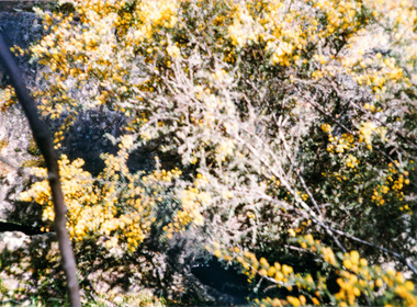
Photograph, Doug Orford, Aboriginal waterholes at Maryborough, Spring Excursion to Maryborough, 27 September 1992, 27/09/1992
[from EDHS Newsletter No. 86, September 1992:] SPRING EXCURSION MARYBOROUGH: As a Spring excursion our bus trip on 27th September is well timed - Maryborough is conducting its Wattle Festival on that weekend. We are to be guests of the Midlands Historical Society who will provide a guide for our tour of the town. This is a somewhat longer trip than we usually undertake so we have an earlier start at 8.00 am and the cost is a little more than usual at $20.00. The entry to the Midlands Society's Worsley Cottage is included. At the end of the town tour we will visit the C.W.A.'s Fair which is part of the Wattle Festival. Afternoon tea will be available there for a small charge. Bring your lunch and something for morning tea if you wish. We will be travelling to Maryborough via Creswick and Clunes and returning via Castlemaine. We will return about 6.00 pm and transport home can be arranged if required. Maryborough has a rich history with the gold era being particularly significant. Local historian Betty Osborne has produced the book "Maryborough - a Social History 1854-1905". You might like to try and obtain it from the library for advance reading or it will be available for purchase on the day at $25.00. To book for this tour please complete the attached from and return with your payment to the September meeting or send it to our post office box. Friends are most welcome as usual.Colour photographactivities, maryborough -
 Eltham District Historical Society Inc
Photograph, Slab hut, Warrandyte, Warrandyte Mystery Tour, 29 May 1994, 29/05/1994
[article by Bettina Woodburn in EDHS Newsletter No. 97, July 1994:] THE WARRANDYTE MYSTERY TOUR MAY 29TH 1994 - Members of the Eltham Historical Society met at the Old Post Office, now converted into the Warrandyte Historical Museum, for a picnic lunch on the sunny back verandah overlooking the shimmering Yarra River. Interesting photographs and artefacts filled various rooms outlining the history of this area, and told tales of Aboriginal and more recent neighbours of the Eltham Shire. The weather was calm, cloudy mostly with only occasional sunny patches, but it wasn't cold, although the autumnal leaf colours had changed to wintry brown. "All Aboard" and we set off in the Warrandyte Community Bus (with the School Bus sign displayed at the rear) to learn about local places of "Pride and Joy” from Bruce our guide and Tom the driver. Almost directly opposite we entered Whipstick Gully to explore the first of the district's hidden treasures - the Victory, one of the largest of the six or so major mines, past the old quarry now used for abseiling practice. By torchlight we entered the rocky hillside and saw the seams of quartz the miners had followed in their search for gold. Stamping batteries, and there was one in this gully, converted discarded rock into 'road metal'. Warrandyte is proud to be the first declared Goldfield in 1851, and one of the longest surviving, into the 1920s. A pleasant drive across the Bridge and along Bradley's Lane to Norman's Reserve brought us to see another Tunnel at Pound Bend through which the Yarra was diverted to allow about three miles of river-bed to be used for prospecting for alluvial gold. Still on this side of the river we visited the Old Slab Hut in Castles Road. This remnant of miners' housing is preserved because it had been incorporated into a weatherboard house, and saved from the bulldozers - a last minute reprieve, for preservation, by the National Trust. Devastating bush fires have destroyed other old cottages built of wattle and daub, with bark roofs and stone fire-places. The Cairn commemorating the disclosure of Gold Discovery at Warrandyte on June 30th 1851 beside Anderson's Creek Road was our next point of historical interest. We drove on to South Warrandyte and circled back to above the ford on Anderson's Creek to the entrance of the 4th Hill Mine. Again we crept along with our torches, careful of the low roof-rock, and side shafts. At a junction in a large cavity we were able to stand, look up a long air-vent which some 'cavers' climb down, and marvel at, and experience an aspect of a miner's life. Outside we heard the same bird songs, the trills and bell-pealing, saw the same straggly eucalypts, and a silver leafed wattle in flower, native grasses and ferns, and the neat present day houses, often of Warrandyte stone, perhaps veneered only. The day ended pleasantly, seeing more of the Yarra from Everard Drive, and the water rushing out of the Tunnel at Pound Bend, before returning to afternoon tea or coffee at the Museum. A great day for all concerned - many thanks to the Organisers.Colour photographslab hut, warrandyte, "warrandyte miner's cottage" -
 Eltham District Historical Society Inc
Photograph, Pound Bend tunnel, Warrandyte, Warrandyte Mystery Tour, 29 May 1994, 29/05/1994
[article by Bettina Woodburn in EDHS Newsletter No. 97, July 1994:] THE WARRANDYTE MYSTERY TOUR MAY 29TH 1994 - Members of the Eltham Historical Society met at the Old Post Office, now converted into the Warrandyte Historical Museum, for a picnic lunch on the sunny back verandah overlooking the shimmering Yarra River. Interesting photographs and artefacts filled various rooms outlining the history of this area, and told tales of Aboriginal and more recent neighbours of the Eltham Shire. The weather was calm, cloudy mostly with only occasional sunny patches, but it wasn't cold, although the autumnal leaf colours had changed to wintry brown. "All Aboard" and we set off in the Warrandyte Community Bus (with the School Bus sign displayed at the rear) to learn about local places of "Pride and Joy” from Bruce our guide and Tom the driver. Almost directly opposite we entered Whipstick Gully to explore the first of the district's hidden treasures - the Victory, one of the largest of the six or so major mines, past the old quarry now used for abseiling practice. By torchlight we entered the rocky hillside and saw the seams of quartz the miners had followed in their search for gold. Stamping batteries, and there was one in this gully, converted discarded rock into 'road metal'. Warrandyte is proud to be the first declared Goldfield in 1851, and one of the longest surviving, into the 1920s. A pleasant drive across the Bridge and along Bradley's Lane to Norman's Reserve brought us to see another Tunnel at Pound Bend through which the Yarra was diverted to allow about three miles of river-bed to be used for prospecting for alluvial gold. Still on this side of the river we visited the Old Slab Hut in Castles Road. This remnant of miners' housing is preserved because it had been incorporated into a weatherboard house, and saved from the bulldozers - a last minute reprieve, for preservation, by the National Trust. Devastating bush fires have destroyed other old cottages built of wattle and daub, with bark roofs and stone fire-places. The Cairn commemorating the disclosure of Gold Discovery at Warrandyte on June 30th 1851 beside Anderson's Creek Road was our next point of historical interest. We drove on to South Warrandyte and circled back to above the ford on Anderson's Creek to the entrance of the 4th Hill Mine. Again we crept along with our torches, careful of the low roof-rock, and side shafts. At a junction in a large cavity we were able to stand, look up a long air-vent which some 'cavers' climb down, and marvel at, and experience an aspect of a miner's life. Outside we heard the same bird songs, the trills and bell-pealing, saw the same straggly eucalypts, and a silver leafed wattle in flower, native grasses and ferns, and the neat present day houses, often of Warrandyte stone, perhaps veneered only. The day ended pleasantly, seeing more of the Yarra from Everard Drive, and the water rushing out of the Tunnel at Pound Bend, before returning to afternoon tea or coffee at the Museum. A great day for all concerned - many thanks to the Organisers.Two colour photographswarrandyte, activities, pound bend -
 Glen Eira Historical Society
Document - History of the City of Caulfield
This file contains 4 items: 1/Typewritten document titled ‘The City of Caulfield’. Author and date unknown. 1 page (back and front), 2 copies. Document covers topics such as origins of the name ‘Caulfield’, early settlement and the Caulfield Cup. 2/Typewritten document titled ‘History of Caulfield Council’. Author and date unknown. 6 pages, 3 copies. Document covers subjects such as early settlement, Aboriginal influence, Caulfield Road Board, Shire of Caulfield, Borough and town boundaries, coat of arms, and Freedom of Entry to the City. 3/Typewritten document (undated + author unknown) titled ‘The Structure of Local Government in Victoria with a history of the City of Caulfield’. 13 pages. Covers the following subjects: Powers, Planning, Public Works, Trading Undertakings, Health Services, Municipalities, Wards Electors or Ratepayers, Voters Roll, Councillors, Officers, Finance, Nature of Soil and Vegetation, Parks and Gardens and Reserves, Coat of Arms, Boundaries, How Did Caulfield get its Name, Aboriginal Influence, Caulfield Road Board, Shire of Caulfield, Borough and Town and the City of Caulfield. Also covered is early settlement. Note at the end of the document mentions that the historical content contained in the last section was based upon a thesis for the Department of Town and Regional Planning, University of Melbourne, 1968 by L. Alwis, P. Rowe, N. Wootten. Melbourne, ‘City of Caulfield: An Illustrated City Report’. 4/Typewritten document (undated) titled ‘The Structure of Local Government in Victoria with notes on the history of the City of Caulfield’. 8 pages, 2 copies. This document also includes a map/diagram of the city with boundaries and wards showing locations of railway stations and parks. Document covers the structure of local government and its functions then goes on to focus on City of Caulfield with subjects similar to those covered in item 3. Document signed off by Deputy Town Clerk.city of caulfield, caulfield john, caulfield baron, caulfield racecourse, elsternwick, ripponlea, st. mary’s church, caulfield council, kooyong road, neerim road, bambra road, greenmeadows house, caulfield park, paddy’s swamp, dandenong road, caulfield grammar school, chisholm institute of technology, murrumbeena, glen eira road, alma road, orrong road, balaclava road, inkerman road, ‘grosmont’, caulfield school room, caulfield road board, caulfield road district, crimean war, victorian amateur turf club, caulfield cup, glenhuntly road, north road, glenhuntly station, ormond station, outer circle railway, local government, gardenvale, carnegie, rosstown, poath road, nepean highway, hotham street, ormond park, princes park, ross william murray, caulfield institute of technology, ‘ross’ folly’, hawthorn road, glenhuntly, ormond, morris t. w., lloyd charles du plan, meals on wheels, shire of caulfield, caulfield railway station, caulfield rsl, bouran road, murrum murrumbeen, kooyong road, great dandenong road, neerim road, trams, prahran and malvern tramways trust, fisher andrew, mackinnon reserve, dover street, ‘glen eira’, blair max cr., insignia, third ordnance services unit, schools, street lighting, lampriere, mr. bevan, the caulfield leader, davies j. henry, curraweena road, st. georges road, o’neill college, hope george, market gardens, koornang reserve, packer reserve, murrumbeena reserve, hopetoun gardens, greenmeadows gardens, mirambeena, caulfield technical college, hart john, langdon h. j., ‘rosecraddock’, judge webb, ‘crotonhurst’, service james, ‘kilwinning’, ricketson henry, grimwade frederick sheppard, airdrie, jenner, st. aubin’s, caulfield john p. t., harlston, lempriere, lord reserve, ‘cantala’ -
 Federation University Historical Collection
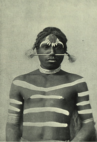
Image - black and white, Barwon River Man (New South Wales)
Digitised directly from 'The Native Races of the British Empire: Victoria' The Barwon River in New South Wales is formed through the confluence of the Macintyre River and Weir River (part of the Border Rivers system), north of Mungindi, in the Southern Downs region of Queensland. The Barwon River generally flows south and west, joined by 36 tributaries, including major inflows from the Boomi, Moonie, Gwydir, Mehi, Namoi, Macquarie, Bokhara and Bogan rivers. During major flooding, overflow from the Narran Lakes and the Narran River also flows into the Barwon. The confluence of the Barwon and Culgoa rivers, between Brewarrina and Bourke, marks the start of the Darling River.Black and white Image of an Aboriginal man from Barwon River, New South Wales. Aboriginal people from six language groups originally occupied the area of the Barwon River wetlands. These were the Ngemba, the Baranbinja, the Murrawari, the Ualayai, the Weilwan, and the Kamilaroi peoples. The Aboriginal people generally used the wetlands for hunting, fishing, and gathering uses, and for cultural association.(Wikipedia) The name "barwon" is derived from the Australian Aboriginal words of barwum or bawon, meaning great, wide, awful river of muddy water; and also baawan, a Ngiyambaa name for both the Barwon and Darling rivers. The history, culture and livelihoods of the local Aboriginal people are closely intertwined with the Barwon River and its associated tributaries and downstream flows. (Wikipedia)aborigine, aboriginal, barwon river -
Federation University Historical Collection
Costume, Federation University, Indigenous Uni Games Polo Shirt, Approx 2019?
National Indigenous Tertiary Education Student Games (NITESG) began in 1996. Now referred to as Indigenous Nationals, the event is a week-long multisport competition for indigenous student-athletes. The annual event aims to bring together athletes from universities across Australia to compete in a variety of sports and ultimately crown one university team the champion of the games. Indigenous Nationals seeks to also acknowledge the heritage and history of the participating athletes. This new synthetic shirt (still with tags attached) has short sleeves, a collar and three white buttons set in a placket at the neckline. The colour ranges from mid blue at the top to a dark blue with spots at the bottom. On the front is printed the FedUni logo on the left breast and on the right side is printed Indigenous Uni Games and the Aboriginal and Torres Strait crossed flags at the breast and below is a design and a platypus. The same design is repeated on the left sleeve and on the right sleeve is a logo for the Central Highlands Local Aboriginal Network. The number 28 is printed on the back.Makers brand is stamped on the inside back neck.federation university, indigenous uni games, indigenous nationals, central highlands local aboriginal network, polo shirt -
 Ringwood and District Historical Society
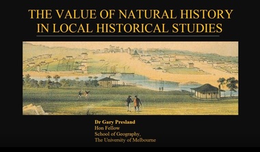
Mixed media - Video, RDHS Guest Speaker Presentation - "The Value of Natural History in Local Historical Studies" - Dr Gary Presland FRHSV, School of Geography, University of Melbourne
Digitised video (4.41GB). Duration: 63 minutes. Recorded March, 2018. (Video is available for viewing at Ringwood & District Historical Society Archives by appointment)Presenter: Gary Presland is an Australian archaeologist and writer who studied history at LaTrobe University, 1973-76 and archaeology at the University of London, 1977-79. He was a staff member of the Victoria Archaeological Survey from 1983 to April, 1988. His research interests are in the Aboriginal and natural history of Melbourne. -
 Yarra City Council
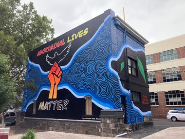
Artwork, other - Mural, Ky-ya Nicholson-Ward, Aboriginal Lives Matter, 2021
"The fist references the Black Lives Matter movement and also represents the strength of Indigenous peoples all over the world and symbolises solidarity and justice for everyone affected by systematic racism. Bunjil (wedge-tailed eagle) is flying high on the building. He is the creator spirit for Wurundjeri people who looks over us and protects us. Bunjil represents healing and power to our people. The blue circles and lines represent revival and waterways; in particular, they depict the Birrarung (Yarra River), which is very significant for the Wurundjeri people. Our people are known as the Manna Gum people. The leaves in the artwork highlight Wurundjeri people and their Country. These leaves also represent the cleansing of negative spirits. The Manna Gum leaf is also an important symbolic offering in our traditional Welcome to Country ceremony. Leaves are offered to visitors as they are granted safe passage through our land. They are made welcome to everything from the tops of the trees to the roots of the earth. We ask that they take care of the land, plants and animals and to respect the protocols and rules of the Traditional Owners whilst on our Country."In 2020 Council declared its support for the global Black Lives Matter (BLM) movement. In consultation with Yarra City Council's Yana Ngargna advisory group a motion was prepared and passed unanimously by all Councillors. A number of actions were generated from this decision; one of which was for Council to commission a large-scale mural that aligned with the movement. Emerging artist Ky-ya Nicholson-Ward, a proud Wurundjeri, Dja Dja Wurrung, Nguarai Illam-Wurrung, German and Irish woman, created the mural installed on a building in Peel Street Park, Collingwood. Selected by Council's Yana Ngargna, Black Lives Matter Working Group the artwork identifies the cultural importance of the local area to the Wurundjeri Woi Wurrung people as the Traditional Owners. With a strong focus on Aboriginal identity the mural outlines the local context of the Black Lives Matter movement, which is connected to racism, policing of Aboriginal and Torres Strait Islander peoples and associated deaths in custody. The artwork acknowledges the ongoing challenges faced by Aboriginal community members and their struggle to survive white systems, policies and institutions. Ky-ya's mural tells the story of Aboriginal resilience, strength and self-determination; and will support the process of healing. It is a celebration of the local Aboriginal and Torres Strait Islander community; the significant Aboriginal history of Fitzroy, Collingwood and surrounds; and community's continuing cultural connection to the area. Importantly, this artwork provides a platform to educate a broader audience about the local context of the Black Lives Matter movement and Aboriginal deaths in custody. The mural will activate this site, enliven the area, promote inclusion, incite conversation and contribute to the creative capital of this locale. A welcoming environment for Aboriginal and non-Aboriginal communities.Aboriginal Lives Matter Ky-ya Nicholson WardOn a black background a hand fist (strength, solidarity and justice) is placed at the centre of the building; Bunjil (wedge-tailed eagle) is depicted flying high on the building; blue circles and lines represent revival and waterways (Birrarung-Yarra River) and the leaves in the artwork highlight Wurundjeri people (cleansing of spirit and welcome to Country)The artist name 'Ky-ya Nicholson Ward' painted in white, low right of the wall facing into Peel Street Park. black lives matter (blm) movement, wurundjeri woi wurrung, bunjil, identity, birrarung, country -
 Jewish Museum of Australia
Chess set
This chess set was carved from local wood with bases made from halved cotton reels. The chess pieces take the shape of Australian animals, and Aboriginal men and women. The set was presented to Mr. Benzion Patkin, Honorary Secretary of the Zionist Federation of Australia, by Tatura internees in recognition of his assistance, in particular, his assistance in facilitating the emigration to Palestine. According to Mr. Patkin, he received the chess set in a wooden box inscribed, "With our sincerest thanks from your Zionist friends - Tatura, on the way to Eretz Israel, per Leonhard Levin, 20.11.1942.".Written in pencil UR corner, upside down: (22) Printed in black ink: "B. & H. PATKIN Flat (printed 2 corrected in pen and ink 4) 313a Dandenong Road Windsor 3181 Victoria Australia Tel: Home 51 - 5671 Bus 63 - 8959"dunera, wwii, internees, jewish history & people -
 Tatura Irrigation & Wartime Camps Museum
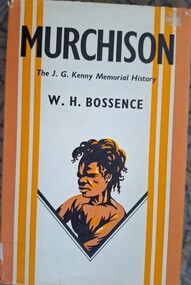
Book, Murchison, 1965
Written as a memorial to his friend JG KennyOrange and white dust jacket. The JG Kenny memorial history. WH Bossence. Aboriginal figure. Brown hard cover. Cover design by Anne Bossence.murchison, history of murchison, bossence w, tatura, pioneers of murchison, books, history, local -
Tatura Irrigation & Wartime Camps Museum
Leaflet, Local Places of Historical Interest, 1972
Recorded by Nagambie & District Historical Society. History of Kirwan's Bridge, Angustown, Aboriginal Camp Ovens, Day's Mill, Old pumping station site, Goulburn Weir.Gold cover, black writing. Compiled September 1972books, history, local -
Tatura Irrigation & Wartime Camps Museum
Leaflet, Local Places of Historical Interest, 1972
Recorded by Nagambie Historical Society. History of Kirwan's Bridge, Angustown, Aboriginal Camp ovens, Day's Mill, Oold pumping site, Goulburn WeirGold cover, black writing. Compiled September, 1972books, history, local -
Tatura Irrigation & Wartime Camps Museum
Booklet, The Abstract Art of the Aranda, 1960
Soft yellow card cover booklet with black printing front and back. Volume 55, 1960. Includes copies of some aboriginal art carvingsww2 camp 2, books, history, local -
Tatura Irrigation & Wartime Camps Museum
Booklet, History of the Waranga Basin, 1989 (reprint)
Includes details of construction of Waranga systemBuff soft covered book with map of Waranga Basin and text in brown Written by Joyce Hammond giving historical information from aboriginal presence to the situation in 1977 with reference to members of the Gunn and Hammond familiesirrigation, boat club, books, history, local -
Tatura Irrigation & Wartime Camps Museum
Booklet, Hiking from the Australian Jamboree, 1935
Souvenir booklet printed for 1935 Frankston Jamboree. A hike to Gilwell Park, Gembrook. Booklet contains fold out maps of hiking areas. Also early aboriginal history of Victoria and in 1837, when John Gardiner occupied Mooroolbark sheep station.Small brown covered booklet, black writing. Sketch of Scout in hiking gear on front. Scout Emblem and kangaroo, Australian Jamboree, Frankston, Vic 1935 on back cover.scouting, books, history, local -
 City of Ballarat
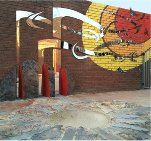
Artwork, other - Public Artwork, Marley Smith et al, Campsite by Marley Smith and Billy Blackall, 2020
The Campsite mural features Bunjil (wedge-tailed eagle) the creator and spiritual leader for Aboriginal people of this land. The Baarlijan (platypus) is a representation of the local Aboriginal community who have come from different Aboriginal nations and have made Ballaarat their home. The circular motifs represent campsites of different sizes located across Ballaarat, indicating that Ballaarat was and continues to be an important meeting place. Campsite (2020) is a re-commissioned artwork based on the original Campsite Mural installed in Alfred Deakin Place for the Commonwealth Games in 2006. The Campsite mural features Bunjil (wedge-tailed eagle) the creator and spiritual leader for Aboriginal people of this land. The Baarlijan (platypus) is a representation of the local Aboriginal community who have come from different Aboriginal nations and have made Ballaarat their home. The circular motifs represent campsites of different sizes located across Ballaarat, indicating that Ballaarat was and continues to be an important meeting place. Commissioned by the City of Ballarat. Painted mural on six weatherproof sheetsbunjil, baarlijan, aboriginal history, ballarat history, wadawurrung -
 City of Ballarat
Artwork, other - Public Artwork, Leaf Design Studio, Coming Home to Nest by Katherine Masiulanis
At the crossover between placemaking and public art, this space designed and constructed by Katherine Masiulanis embeds local stories to enliven the local community centre. Masiulanis has designed the public artwork to reflect the lines of crops and ploughed fields and mountains in the surrounding landscape. The artwork also refers to the seasonal travel of Aboriginal people from Wendouree to Burrumbeet and migratory birds making a similar journey. The style of the refurbished courtyard will reflect the 1970s positivity style reflected in the Community Centre architectural design and the history of the first development of the ‘Village’. Cardigan Village is home to about 450 residents on the outskirts of Ballarat. It was established in the 70s, with all the positivity and optimism of the period.Painted walls, metal bird shapes, metal cut out wall shapes, stone bowl -
Tatura Irrigation & Wartime Camps Museum
Book, Groote Eylandt Art Leonhard Adam Ethnological Collection Part 1, 1973
Dr. Leonhard Adam studied both Anthropology and jurisdiction as a young manBlack and brown soft cover with aboriginal type art on the front and back covers, plastic slotted spine. Collection of productions of Groote Eylandt artifacts. Written in Englishgroote eylandt art, adam l, adam murvitz mc, camp 2, tatura, books, history, local -
Tatura Irrigation & Wartime Camps Museum
Booklet, The Leonhard Adam Collection, 1988
Dr. Leonhard Adam studied both Anthropology and Jurisdiction as a young manDark blue soft cover with picture of artefacts on the front and back covers. 3 pages of reproduction of aboriginal artefacts together with list and numbers of artefacts. Printed in Englishbooks, history, local -
 Tatura Irrigation & Wartime Camps Museum
Book, Murchison, 1965
Written as a memorial to his friend JG KennyOrange and white dust jacket. The JG Kenny memorial history. WH Bossence. Aboriginal figure. Brown hard cover. Cover design by Anne|Bossence.murchison, history of murchison, bossence w, tatura, pioneers of murchison, books, history, local -
Victorian Aboriginal Corporation for Languages
Book, P D Gardner, Through foreign eyes : European perceptions of the Kurnai tribe of Gippsland, 1994
This book is the second of Gardner's 3 volume history on the Kurnai tribes. It studies the Kurnai through the diaries and letters of various European observers, including an explorer, squatters, government officials, Aboriginal protectors, missionaries and an anthropologist. There is also an account of one of the victims, a summary of Gardner's massacre thesis and an appendix on the 'white woman' affair. This book is considered the most professional production of the trilogy and was highly commended in the Caltex-Bendigo Advertiser Awards of 1988. B&w illustrations, b&w photographshistories, victorian aborigines, victorian history, local history, victoria, gippsland, kurnai, european -
 Victorian Aboriginal Corporation for Languages
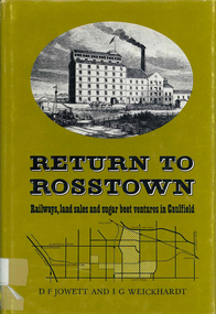
Book, D F Jowett et al, Return to Rosstown : railways, land sales and sugar beet ventures in Caulfield, 1978
The story of the attempt to establish the Rosstown industrial and residential complex in the Caulfield district, south-east of Melbourne, during the second half of the nineteenth century. The focus of the scheme was a major beet processing mill, the Rosstown Sugar Works. It also looks at the railways lines which serviced the sugar beet ventures in the Caulfield/Rosstown area.victorian history, local history, town planning, william murray ross, rosstown estate, rosstown railway -
 Victorian Aboriginal Corporation for Languages
CD-ROM, Informit, Family history OnDisc : information resources for genealogists, 1998
CD-ROMgenealogy, local history -
Victorian Aboriginal Corporation for Languages
DVD, Bernadette Crawford, Brewarrina's Aboriginal language program, 1998
The language program was developed by teachers at Brewarrina, and is designed to appeal strongly to the imaginations of their students. The students are encouraged to work in groups and individually to unearth their local history and cultural backgrounds, by studying family trees and gathering oral histories, by making excursions to significant sites, and by re-discovering Aboriginal language and cultural practices.DVDbrewarrina central school, aboriginal language program, multiculturalism, genealogy, local history, research -
 Victorian Aboriginal Corporation for Languages
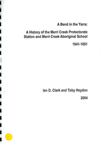
Book, Ian D Clark et al, A Bend in the Yarra : a history of the Merri Creek Protectorate Station and Merri Creek Aboriginal School 1841-1851, 2004
Spiral bound publication on the History of the Merri Creek Protectorate Station 1841-1851, with major references to Robinson and Thomas. Extensive bibliographic notes and references.tableswoiwurrung, woi wurrung, boonwurrung, boon wurrung, eastern kulin, derrimut, william thomas, yarra, merri creek, local history, victorian history, education -
 Victorian Aboriginal Corporation for Languages
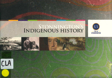
Book, Ian D Clark et al, Stonnington's Indigenous history, 2006
This document is a summary of 'An indigenous history of Stonnington (2006) by Dr Ian Clark and Laura Kostanski, University of Ballarat.maps, b&w illustrations, b&w photographs, colour illustrations, word listswoiwurrung, woi wurrung, boonwurrung, boon wurrung, eastern kulin, derrimut, george augustus robinson, george langhorne, helen baillie, banjo clarke, jim berg, stonnington, william thomas, coranderrk, local history, victorian history, -
 Victorian Aboriginal Corporation for Languages
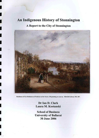
Book, Ian D Clark et al, An Indigenous history of Stonnington : a report to the City of Stonnington, 2006
This report presents the results of historical research into the Aboriginal history of the City of Stonnington.maps, colour illustrations, b&w illustrations, colour photographs, tableswoiwurrung, woi wurrung, boonwurrung, boon wurrung, derrimut, william thomas, stonnington, local history, victorian history -
 Victorian Aboriginal Corporation for Languages
Book, Gregory C Eccleston, Major Mitchell's 1836 "Australia Felix" expedition : a re-evaluation, 1992
Journal style notes with maps and illustrations of the journey of Major Mitchell.maps, b&w illustrations, colour illustrations, tablesthomas mitchell, australia felix, northern victoria, western victoria, local history, exploration -
 Victorian Aboriginal Corporation for Languages
Book, Megan Goulding et al, Moreland post-contact Aboriginal heritage study, 2006
This study aims to identify Aboriginal heritage sites and landscape associations in the Moreland municipality that date from the pre-contact period through to the early contact period when Europeans settled in and around the area, to the present day.maps, colour photographs, b&w photographs, tableswoiworung, woi wurrung, wurundjeri, waa, bunjil, werribee river, port phillip, mount baw baw, great dividing range, yarra river, eastern kulin, gunung willam balluk, william barak, john batman, william thomas, moreland history, moieties, local history, colonisation