Showing 5774 items
matching location
-
 Eltham District Historical Society Inc
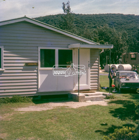
Slide - Photograph, Holiday cabin, Leonard, unidentified location, possibly Kinglake, c.1973
35mm colour positive transparency blue Agfacolour Service plastic mountholiday cabin, jwx677 (vic registration), leonard, toyota corolla (1967), unidentified -
 Eltham District Historical Society Inc
Photograph, Monument containing a time capsule in celebration of Victoria's 150th Anniversary and marking the location of the original centre of Eltham township, c. October 1990, 1990
Roll of 35mm colour negative film, 4 stripsKodak GC400-8monuments, plaques, time capsule -
 Greensborough Historical Society
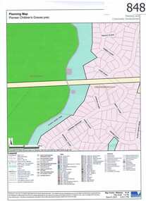
Map, Plenty River Children's Cemetery - location map, 1848-1860
The unmarked graves of the children of two Greensborough pioneer families lie in a private cemetery on the Plenty River. Burials occurred between 1848 and 1860.The significance lies in the association with two of the pioneer families of the Greensborough district. Descendants of both families still live in the area.One page map accompanies article item #804 -
 Eltham District Historical Society Inc
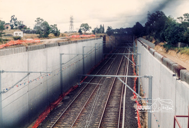
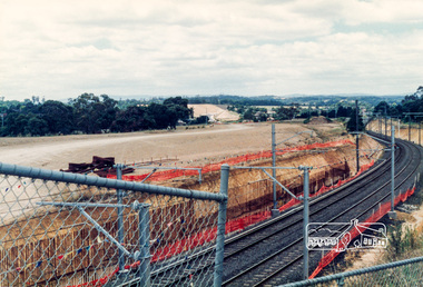
Photograph, Looking southwest from the location of the new overpass being constructed over the railway line near Watsonia Railway station; Greensborough Bypass construction, c.1986, 1986c
Colour photograph originally located in a magnetic style album titled 'Greensborough Bypass 1990s 5' suffering significant degradation. No information contained in album or on reverse of photos except where noted. Relocated to archival photosafe storage.greensborough bypass, road construction, greensborough, watsonia railway station -
 Eltham District Historical Society Inc
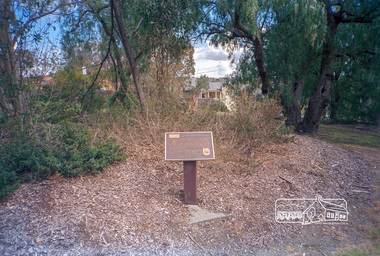
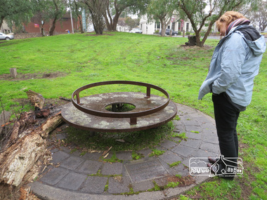
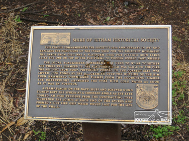
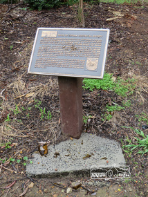
Photograph, Liz Pidgeon, Monument containing a time capsule in celebration of Victoria's 150th Anniversary and marking the location of the original centre of Eltham township, 21 June 2017, 21 June 2017
A walk around Little Eltham, 21 June 2017 Newsletter No. 175 July 2007 FORTY YEARS IN HISTORY The Society has been involved with a number of one off historical projects that have lasting outcomes. Perhaps the most significant is the monument and time capsule installed at the Eltham Community Centre site at the comer of Pitt Street and Main Road to commemorate Victoria's 150th anniversary. The monument based on a blacksmith's tyring plate was designed by artist Joh Ebeli. Beneath it is a time capsule containing items from 1985 and donated by Graham Beyer. It is to be opened in 2035.Born Digitalmain road, time capsule, monuments -
 Eltham District Historical Society Inc
Photograph, Liz Pidgeon, Monument containing a time capsule in celebration of Victoria's 150th Anniversary and marking the location of the original centre of Eltham township, 21 June 2017, 21 June 2017
A walk around Little Eltham, 21 June 2017 Newsletter No. 175 July 2007 FORTY YEARS IN HISTORY The Society has been involved with a number of one off historical projects that have lasting outcomes. Perhaps the most significant is the monument and time capsule installed at the Eltham Community Centre site at the comer of Pitt Street and Main Road to commemorate Victoria's 150th anniversary. The monument based on a blacksmith's tyring plate was designed by artist Joh Ebeli. Beneath it is a time capsule containing items from 1985 and donated by Graham Beyer. It is to be opened in 2035.Born Digitalmain road, time capsule, monuments -
 Ringwood and District Historical Society
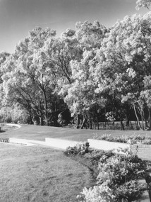
Photograph, Ice on trees in golf links. Location and Date unknown
Written on back of photograph, "Ice on trees in golf links". No mentioned on which golf links. -
 Ringwood and District Historical Society
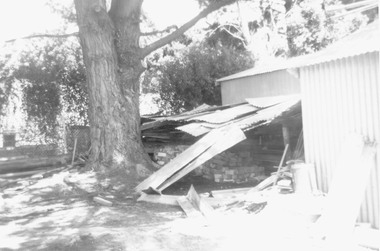
Photograph, Sections of the miner's cottage removed from it's original location on Maroondah Highway to the council depot in January 1979, but never used in eventual reconstruction at Ringwood Lake in 1983
Catalogue card reads, "January 1979. Miner's cottage in pieces at second resting place, in council depot near front gate - on left under big pine tree". -
 Ringwood and District Historical Society
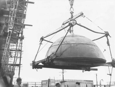
Photograph, Ringwood Clocktower dome retained from Warrandyte Road location being placed on new tower at Wantirna Road site - 1967
B&W photograph. See also VC 2397 for other images of the clocktower under constructionWritten on backing sheet, "Dome of old tower being placed on new one - 1967". -
 Ringwood and District Historical Society
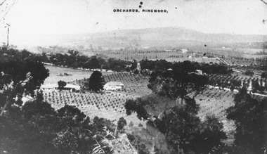
Photograph, View of Ringwood from Loughnans Hill. Pollards tank stand (centre) is on south side of Warrandyte Road. (Later location of Lauriston Crt.)
Black and white photograph looking down on orchards. House in centre of photograph, mountains in background. (3 copies)Written on back of one photograph, "Pollards tank stand" (centre) -
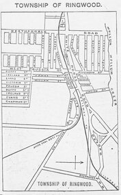 Ringwood and District Historical Society
Photograph, Directory of Ringwood Township, from Sands and McDougall Directory - 1905. (New Street is incorrectly shown as Heatherdale Road on this map. Heatherdale Road's actual location is to the east, beyond the top of the map perimeter.)
Catalogue card reads, 'Directory of Ringwood Township - 1905. From Sands and McDougall Directory.' -
 Federation University Historical Collection
Book, Market Centers and Retail Location: Theory and Applications, 1988, 1988
Robert H.T. Smith was Chancellor of University of Ballarat (later Federation University Australia)Blue and brown hard covered book.markets, retail, robert h.t. smith -
Federation University Historical Collection
Book, Rand McNally & Company, Readings in Economic Geography: The Location of Economic Activity, 1968, 1968
Robert H.T. Smith was Chancellor of University of Ballarat (later Federation University Australia)Hard covered book with black dust jacket.robert h.t. smith, economic geography, geography -
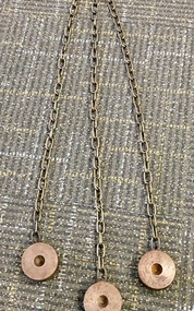 Federation University Historical Collection
Instrument - Scientific Instruments, Tripod Location Chains
Surveying instrument accessories. Two sets. Used in conjunction with item 4129 - Collapsible leg surveying instrument, tripod. Could also be used with item 4130 - Plane Table which goes with the tripod mentioned.A set of three steel discs, connected in star configuration by three brass chains of equal length. Used to contain tripod ends on hard smooth surfaces.surveying, metal, steel discs, scientific instruments, location chains, plane table -
Moorabbin Air Museum
Manual (item) - Radio Location Techniques Vol 7, HM Stationery office 1960
-
Moorabbin Air Museum
Manual (item) - Douglas DC-9 Component Description & Location List
-
Moorabbin Air Museum
Drawing - CAC Commonwealth Aircraft Corporation, Avon Test House Plan ATAR Engine Control Location
-
Moorabbin Air Museum
Document (item) - Government Aircraft Factories Report on Fishermen's Bend Facilities, Report on the Limitations of the Fishermens' Bend Test Flying Field and Recommendations for the Transfer of Test Flying and Allied Factory Operations to a More Suitable Location
-
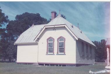 Buninyong & District Historical Society
Photograph - Original Colour Photo of Garibaldi School, Former Garibaldi School. Photo taken of the south face, restored by community and now used as a community hall. Location on Hardie's Hill Road, 1986
Original building was Garibaldi School that was restored by the local community to become the Garibaldi Community Hall around 1986Former school houseColour photo of former Garibaldi School, now Garibaldi Community Hall. Photo taken of south face. garibaldi, school, community hall -
Moorabbin Air Museum
Photograph (Item) - photos of early biplanes & Amphibious biplanes [incl some buildings and ships in harbour - location unknown]
-
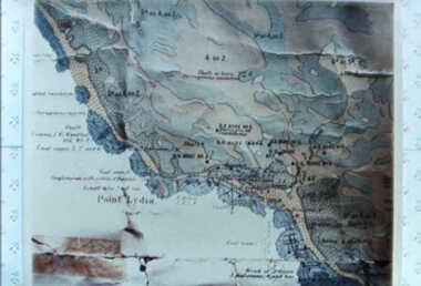 Inverloch Historical Society
000587 - Map - Point Lydia - Harmers Haven - Location of coal test bore holes - from Iris Earnshaw
-
 Inverloch Historical Society
000081 - Photograph - Location possibly Venus Bay - R Young
-
Clunes Museum
Decorative object - LETTER, SUPP. FILE - COPIES FROM INVERNESS PUBLIC LIBRARY, REG. NO. 658.2.3 (LOCATION UNKNOWN), 1973
PART OF MR. WEICKHARDT'S HISTORICAL COLLECTION.LETTER FROM LIBRARIAN & CURATOR, INVERNESS PUBLIC LIBRARY & MUSEUM TO MR. WEICKHARDT WITH REFERENCE TO HIS ENQUIRY REGARDING AN ESTATE PURCHASED BY DONALD CAMERON IN SCOTLAND CALLED "CLUNES".local history, document, letter, weickhardt -
Swan Hill Regional Art Gallery
Painting, STRATH, Robert, North of Sydney location, unknown
-
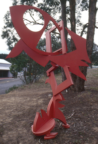 Nillumbik Shire Council
Public Art: Edward GINGER (b.1951 Kegalle, Sri Lanka - arrived 1975 Aus), Edward Ginger, The Breeze, Location: Main Road, Research - opposite Eltham Little Theatre, 1990
The first sculpture awarded the Shire of Eltham 'Art in Public Places' Award/Commission. The Judges were Inge King, Jenny Zimmer and Daryl Jackson. The work deals with the juxtaposition of suburban and rural surroundings. This scupture is a typical example of the artist's oevre of the period. This sculptre is site specific and refers to the nature of the environment. The colour - bushfire red / sienna - alludes to the history of fire in the urban/rural fringe and the title, as well as the sculpture's shapes, forms and material refer to the natural and local elements. Judges report noted: "The most vital and expressive work for the site...with a great sense of dynamic movement and vibrant colour. Its' abstract forms will enliven the surroundings and the urban and natural environment. This work is the most appropriate for the site and expressive of the dynamics of an evolving community in which artistic discourse and debate has always thrived." The work has acquired the status of a major landmark from the National Trust. The Breeze is an abstract work made out of welded steel and painted in enamel in bush fire red / sienna. It comprises a series of flat, cut-out shapes, interlocking at different angles, giving the impression of being hinged together rather than fixed. The work references nature and the built environment. Its geometric shapes suggest man-made structures within industry and suburban life, while rural areas can be identified by the organic flame-like shapes fanned by the wind. The circular cut-out in the eye mimics the sun, symbolising the intense heat of the Australian climate, while the colour red alludes to the history of bushfire within the urban and rural fringe. N/Apublic art, ginger, red, sienna, elements, steel, abstract, breeze, fire, sculpture -
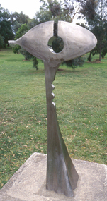 Nillumbik Shire Council
Public Art: Ernst FRIES (b.1934 Wurzburg, Germany - arrived 1959 Aus), Ernst Fries, Surveyor of Suburban Environs, Location: Alistair Knox Park, Main Road, Eltham, 1991
'Surveyor of Suburban Environs' was one of the acquisitions from the 1991 Eltham Art Awards (now known as the Nillumbik Prize - and formally the Nillumbik Art Awards). This was the first piece acquired from this award which was suitable for a public space. Nillumbik is referred to as the "Green Wedge" and the sculpture "Surveyor of Suburban Environs" suggests a watchful observer of the surrounding landscape. The sculpture's central motif represents an eye held up on a pedestal by a tail. Its form has been likened to the Eye of Horus, an ancient Egyptian symbol of protection, royal power and good health personified in the goddess Wadjet or 'green one'. This likeness would suggest that the observer or surveyor has a divine status and spiritual connection to its environment. Polished stainless steel sculpture comprising an eye reminiscent of ancient egyptian hieroglyphics, which is held up with a tappered and jaggered tail like pedestal. Concrete base. N/Apublic art, fries, spiritual, eye, stainless steel, goddess, surveyor, sculpture, environment -
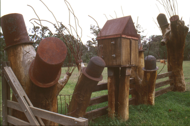 Nillumbik Shire Council
Sculpture: Tony Trembath (b.1946 Sale, Victoria), Tony Trembath, The Fences Act 1968 - Location: Edendale Farm (entrance) 30 Gastons Road, Eltham, 1989 - 1994
Eltham Council (now the Shire of Nillumbik) commissioned this work in 1989 to create an entrance / gateway to Edendale Community Farm. It was also aided by a grant from the Ministry of the Arts (now Arts Victoria). The former name of this work was "Gateway to Edendale Farm". Edendale Farm is a demonstration farm modelling sustainable environmental practices, providing support to the local residents of Nillumbik. Established in 1986, the land was purchased in 1970. It was previously an English gentleman's residence and was used for grazing. It consists of 5.6 hectares, with the Diamond Creek meandering through the property. The Victorian Fences Act 1968 governs liability of occupiers of adjoining lands to fence, and deals with disputes between neighbours regarding boundaries fences and costs. This work took into consideration ideas and suggestions from residents and committees, who required the use of recycled materials and that the work celebrate man's relationship with nature, animals and the earth, as well as relate to the fence-line on the far side of the carpark. Trembath also absorbed significant aspects of local history, making references to Eltham's agricultural past, the clearing of the land, the destruction of trees, the ruthless pruning of trees by suburban Councils and incorporated such Australian features as the post and rail fence. 'The Fences Act 1968' is significant for aesthetic, historic and social reasons at a regional level. It makes prominent the historical and social significance of Edendale and the rural aspects of Nillumbik. The use of existing tree stumps and salt pots in the work explores the iconography of the countryside such as the isolated farmhouse, pioneering farming practices, post and rail fencing and the regrowth of lopped trees. The title of the work, as well as the extensive community involvement in its creation, also makes reference to the Victorian Fences Act 1968, which makes neighbours jointly responsible for the cost of construction and maintenance of fences in the partitioning of land for settlement. 'The Fences Act 1968' has been classified as of regional significance by the National Trust of Australia. The work is an installation of wood and metal, approximately twenty five meters long. The design is very informal and rustic and runs the full width of the fence-line. It comprises groups of recycled tree trunks fitted with metal caps (chrome-nickel 'salt pots' that are shaped like tall bowler / top hats). Metal rods protrude from the trunks and some of these rods have metal birds. Two larger, sentinel-like stumps at the two outer ends have metal flame-like wings, which bend inward. To the left of the entrance, a simple architectural element indicates an isolated farmhouse. The rustic fence runs between the groups of tree trunks with native planting in clumps along it. The fence-line incorporates a functional engineered double gate and post and rail fencing. There may be many interpretations of the work and the intention is to stimulate interest and imagination rather than alienate. Interpretation is based on the personal experience that a visitor brings. The artist recommended that no explanation of the design logic be positioned with the work. N/Apublic art, sculpture, edendale, recycled, wood, metal, fences act 1968, gate, trembath, salt pot, tree stumps