Showing 622 items matching "location map"
-
 Glenelg Shire Council Cultural Collection
Postcard - Postcard - Mac's Hotel Portland, Victoria, n.d
... , advertisement, map of location on reverse of postcard.... postcard. Depiction of Mac's Hotel Portland, advertisement, map ...Coloured postcard. Depiction of Mac's Hotel Portland, advertisement, map of location on reverse of postcard.Front: 'MAC'S MOTEL-HOTEL' - black print in white border, bottom edge of postcard -
 Melbourne Tram Museum
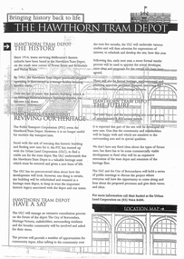
Document - Report, Minister of Transport, "Bringing history back to life - The Hawthorn Tram Depot", Aug. 1998
... of the Hawthorn Tram Depot. Includes a site plan or location map... of the Hawthorn Tram Depot. Includes a site plan or location map ...Report - consultation document titled - "Bringing history back to life - The Hawthorn Tram Depot", 7 A4 sheets, photocopied, outlining the joint Public Transport Corporation (PTC) and Urban Land Corporation (ULC) study into the future of the Hawthorn Tram Depot. Includes a site plan or location map, consultation proposals, news release from the Minister for Transport - Mr Robin Cooper - dated 12/8/1998 and background document providing details of some of the heritage trams - both the PTC and the TMSV. Two copies held - one stapled. Imaged as a pdf file.trams, tramways, hawthorn depot, heritage, minister for transport, tram depot -
Victorian Aboriginal Corporation for Languages
Book, Leon Costermans, Trees of Victoria and adjoining areas, 1994
... Format features leaf identification, map of location, seeds... leaf identification, map of location, seeds and bark etc ...Format features leaf identification, map of location, seeds and bark etc., in black and white drawings.Colour photographs, illustrations, mapstrees, east gippsland, south coast nsw, mallee -
 Whitehorse Historical Society Inc.
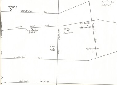
Map, Potteries, n.d
... Sketch map of location of potteries in the area bounded..., Springfield, Mitcham Roads and Burwood Highway. Sketch map of location ...Sketch map of location of potteries in the area bounded by Middleborough, Springfield, Mitcham Roads and Burwood Highway.Sketch map of location of potteries in the area bounded by Middleborough, Springfield, Mitcham Roads and Burwood Highway.Sketch map of location of potteries in the area bounded by Middleborough, Springfield, Mitcham Roads and Burwood Highway.potteries, vitclay pipes pty ltd, blackburn brick and tile co., geal bros., wunderlich limited, australian tesselated tile co. pty ltd., daniel robertson australia pty ltd -
 Ringwood and District Historical Society
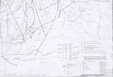
Map - Maps, Geological Map Donvale to Chirnside Park, also Victorian Railways Maps of Hawthorn to Lilydale Line incl Ringwood to East Ringwood - 1881
... map includes location of mine shafts circa 1920..... Geological map includes location of mine shafts circa 1920 ...Faint photocopies of sections of larger maps. Geological map includes location of mine shafts circa 1920.Victory Shaft, North Victory Shaft, South Caledonia Shaft, Caledonia Shaft, North Caledonia Shaft, Black Swan Shaft, Reward Shaft, Consols Shaft, Blocks Shaft, Devonshire Shaft, Crown Shaft, Yarra Tunnel Reef Working, Bright's Shaft, Kingwood Antimony Company Shaft (Boardman's Shaft), Southern Shaft. -
 Federation University Historical Collection
Booklet - Exercise Book, Sebastopol Mines and Socialism
... .1) Black notebook with red spine .2) hand drawn map...) hand drawn map showing location of Sebastopol mines Sebastopol ...Sebastopol is a suburb of Ballarat..1) Black notebook with red spine .2) hand drawn map showing location of Sebastopol minesHandwritten pageswilliam robertson, new lady don company, kohinor company, leviathon company, newington, copenhagen company, hand in hand company, tannery ground, ballarat freehold company, rough and ready company, park company, inkerman alluvial lead, band & albion consols, gravel pits lead, robert gay, sebastopol mines, ballarat east, alluvial, dalton's flat, canadian gully, red streak, montezuma company, great republic company, golden point, gravel pits, j. hardy, scott's boot shop, lady don company, cgt -
 Bendigo Historical Society Inc.
Document - ALBERT RICHARDSON COLLECTION: FORTUNA HUSTLERS MINE
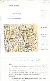
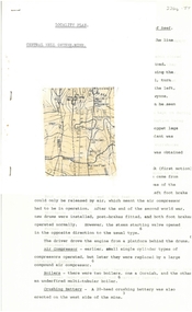
... Two-page document with location map. The Fortuna Hustlers... with location map. The Fortuna Hustlers Gold mine was located close ...Two-page document with location map. The Fortuna Hustlers Gold mine was located close to the railway goods shed (Discovery Centre location) in an area occupied by Buckell and Jeffrey's office and yards. (now carpark of Marketplace shopping centre). It commenced operation in August 1888 and closed in December 1913.The depth of the shaft was 2,240ft. Features of the plant described are: the winding engine, the air compressor, boilers, baling tanks, poppet legs, engine house. The winding engine later worked at the Tambour Major at Specimen Hill; Birds Reef at Kangaroo Flat, Hercules No. 1 on top of Danger Hill and the North Virginia mine at Eaglehawk.bendigo, mining, fortuna hustlers mine -
 Bendigo Historical Society Inc.
Document - ALBERT RICHARDSON COLLECTION: CENTRAL NELL GWYNNE MINE
... Two-page typed document plus location map. The Central... plus location map. The Central Nell Gwynne gold mine ...Two-page typed document plus location map. The Central Nell Gwynne gold mine was located off Happy Valley Road, first turn to the left from Marong Road, and up on the hill. The shaft depth was 1,912 ft. The original plant had small wooden poppet legs and a steam winch which were replaced, in 1935/36 by steel poppet legs obtained from the Virginia mine at Eaglehawk. Features and history of the plant are described including the winding engine, air compressor, boilers, and crushing battery. The dividends and gold production figures are given. The total yield of gold was 61,884 oz.bendigo, mining, central nell gwynne -
 Greensborough Historical Society
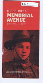
Pamphlet, The Soldiers Memorial Avenue, Queens Domain, Hobart, 2015_
... Avenue Hobart. Includes map, with location of memorial trees.... of the Soldiers Memorial Avenue Hobart. Includes map, with location ...History, description and maps of the Soldiers Memorial Avenue Hobart. Includes map, with location of memorial trees.Single sheet printed in colour both sideswar memorials, hobart -
 Bacchus Marsh & District Historical Society
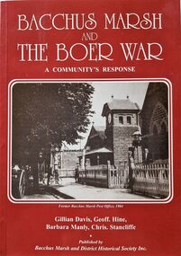
Book, Bacchus Marsh and the Boer War: A Community's Response
... , with illustrations, portraits, and maps. BMDHS Location: AR/SU4..., with illustrations, portraits, and maps. BMDHS Location: AR/SU4 Bacchus Marsh ...An account of the impact of the Boer War upon the community of Bacchus Marsh. Like many communities across Australia Bacchus Marsh saw a number of men enlist in the military forces and participate in the conflict in South Africa between Great Britain and its allies such as Australia against the Boer forces in South Africa in the early 1900s. This work documents this history from the perspective of the individual soldiers involved and the way the community responded to this conflict. Citation: Bacchus Marsh and the Boer War: A Community's Response. By Gillian Davis, Geoff Hine, Barbara Manly and Chris Stancliffe. Published by Bacchus Marsh and District Historical Society, Bacchus Marsh, Vic., 2001.A printed book published in paperback edition. 92 pages, with illustrations, portraits, and maps. BMDHS Location: AR/SU4non-fictionAn account of the impact of the Boer War upon the community of Bacchus Marsh. Like many communities across Australia Bacchus Marsh saw a number of men enlist in the military forces and participate in the conflict in South Africa between Great Britain and its allies such as Australia against the Boer forces in South Africa in the early 1900s. This work documents this history from the perspective of the individual soldiers involved and the way the community responded to this conflict. Citation: Bacchus Marsh and the Boer War: A Community's Response. By Gillian Davis, Geoff Hine, Barbara Manly and Chris Stancliffe. Published by Bacchus Marsh and District Historical Society, Bacchus Marsh, Vic., 2001.bmdhs publication, south african war 1899-1902, boer war 1899-1902, soldiers bacchus marsh vic. -
 Ringwood and District Historical Society
Flyer, Land Sale Advertisement - Roebury Estate, Ringwood, Victoria - circa 1938
... Advertisement for sale of residential allotments with map.... Advertisement for sale of residential allotments with map showing ...Advertisement for sale of residential allotments with map showing location and layout of subdivision, terms of sale, and summary of local features and services.Subdivision includes Dublin Road, Alexander Road, and Ferntree Gully Road (later Bedford Road). Agent - J.B. McAlpin, Opposite Railway Station, Ringwood. -
 Greensborough Historical Society
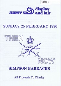
Booklet, Simpson Barracks, Then and now: Army display and fair 1990, 25/02/1990
... Display and fair programme describing events with map...Display and fair programme describing events with map ...Display and fair programme describing events with map of locations, held at Simpson Army Barracks 25/02/1990.8 page booklet with programme and map.Paperaustralian army, watsonia army barracks, simpson army barracks -
Clunes Museum
Booklet - PROGRAM, CLUNES BOOKTOWN 2022
... MAP AND LOCATIONS OF EVENTS BOOKTOWN 2022... FOR CLUNES BOOKTOWN 30/4-1/05/2022 .2 MAP AND LOCATIONS OF EVENTS ....1 PROGRAMME BOOKLET FOR CLUNES BOOKTOWN 30/4-1/05/2022 .2 MAP AND LOCATIONS OF EVENTS BOOKTOWN 2022clunes booktown, booktown 2022 -
 Bendigo Historical Society Inc.
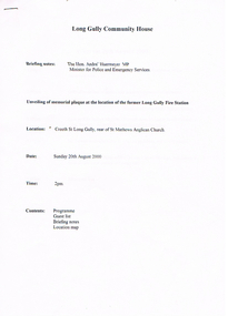
Document - LONG GULLY HISTORY GROUP COLLECTION: LONG GULLY COMMUNITY HOUSE
... . Also included is a location map of the Long Gully Area..... Also included is a location map of the Long Gully Area ...Program for the unveiling of memorial plaque at the location of the former Long Gully Fire Station on the 20th August 2000 at Creeth St Long Gully, rear of St Mathews Anglical Church. List of Dignitaries include Parliamentarians: Hon Andre' Haermeyer MP, Hon Bob Cameron MP and Ron Best MLC. Other Dignitaries: Cr Laurie Whelan, Cr Willi Carney and CFA Bill Davies and Bruce Furnell. Special Guests included Representatives of the Bendigo Fire Brigade, Long Gully Community House, Bendigo and District Cornish Association, Central Victorian Fire Preservation Society and St Mathews Church. Briefing notes include the Plaque, Long Gully and a brief history of the Long Gully Fire Brigade. Also included is a location map of the Long Gully Area.bendigo, history, long gully history group, the long gully history group - long gully community house, the hon andre' haermeyer mp, long gully fire station, st mathews anglical church, george a ellis, long gully history group, bruce furnell, cr laurie whelan, greater city of bendigo, hon bob cameron mp, hon ron best mlc, cr willi carney, bill davies, country fire authority, bendigo and district cornish association, central victorian fire preservation society, mechanics institute, post and telegraph office, cfbb chief officer hennah -
 Kiewa Valley Historical Society
Maps - Tourist
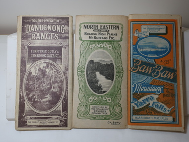
... 3 Tourist location maps (folded) and printed on parchment... location maps (folded) and printed on parchment. 1. Tourist map ...These maps were all dated 1933 which was before the construction of the Kiewa Hydro Electric Scheme and when Tawonga was spelt Towonga. North East Victoria in 1933 was before the construction of the Kiewa Hydro Electric Scheme so the townships of Mt Beauty and Bogong are not shown. The description of the Snow Lines was important as skiers, bushwalkers and campers relied on them. The details on the map include "ADB. Numbered from A.1-377 round plates. CD Numbered from C 1-235 square plates. Poles about 3 chains apart 27 to the mile." 3 Tourist location maps (folded) and printed on parchment. 1. Tourist map of the Dandenong Ranges. Brown cover. dated 6-4-33. Govt. printer showing roads, tracks in red and heights of the land. 2. Tourist Map of Warburton, Mt Baw Baw, and Walhalla. Blue and Orange cover. dated 23-5-33 Govt. printer. 3 different maps of each area showin roads, tracks and timber tramways.Also in red and blue. 3. Tourist Map of North Eastern Victoria including Bogong High Plains Mt Buffalo Etc. Green cover. dated June 1933 Govt. printer. Main map and insert titled Bogong High Plains. Showing roads , tracks and tram ways. On insert showing snow poles. Also Red and Blue and mountains.By Authority of H.J. Green - 6 pence. Dept of Lands and Survey, Melbourne1933 maps, tourism maps, bogong high plains map 1933, snow poles -
Tatura Irrigation & Wartime Camps Museum
Poster, Subdivision of Township Allotments
... on the 3 December 1890. Auctioneer was Martin Cussen and Co. Map... Cussen and Co. Map shows location of land. Rushworth land ...Poster depicting the land which was being sold by J S Darby on the 3 December 1890. Auctioneer was Martin Cussen and Co. Map shows location of land.Single sheet of paper, laminated. Advertising land subdivision for sale in the township of Rushworth. Being sold by Martin Cussen and Co, auctioneers for J S Darby. Shows map of land subdivision.rushworth, land subdivision, martin cussen and co, j s darby -
Southern Sherbrooke Historical Society Inc.
Information folder - "The Bungalow"
... , description and location map./Subdivision maps, 6 sheets./Certificate..., description and location map./Subdivision maps, 6 sheets./Certificate ...Material donated by current owner, Inga Melgaard, 20th November 2006.Folder containing information pertaining to "The Bungalow", Belgrave Heights. Material supplied by current owner, Inga Melgaard, on 20th November, 2006. Contents:/"Specifications of a bungalow for W.J. Murrell's (sic) Esq" drawn up by Leslie J.W.Reed, Architect, "Kaleno", 45 Thanet St, Malvern, dated September 1915./House sale advertisement, showing photograph, floor plan, description and location map./Subdivision maps, 6 sheets./Certificate of Title, Vol. 3892, Fol.778347, dated 28th May 1915, William Joseph Murrells./Certificate of Title, Vol. 6939. Fol. 1387757, dated 31st October, 1946, Agnes Murrells and Nora Murrells./CD containing Certificates of Title, photos taken in 1994 and photos taken by current owner, and a list of previous owners, 1915-1979./Copy of above list. -
 Bacchus Marsh & District Historical Society
Map, Bacchus Marsh Region Parish Plans: Folded set of maps
... Location: AR/SU27/D2: Map Drawers.... Folded. BMDHS Location: AR/SU27/D2: Map Drawers Bacchus Marsh ...Set of Victorian Lands Department Parish Plans covering the township of Bacchus Marsh and surrounding districts. Folded. BMDHS Location: AR/SU27/D2: Map Drawersmaps bacchus marsh region, bacchus marsh victoria maps, interim record -
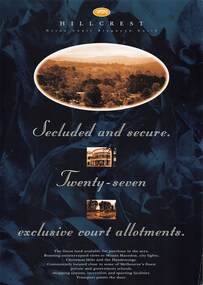 Ringwood and District Historical Society
Flyer, Land Sale Advertisement, Hillcrest Heron Court, Ringwood North, Vic. - c.1994
... map showing location and size of 27 residential allotments... with subdivision map showing location and size of 27 residential allotments ...Double sided A4 gloss print advertisement with subdivision map showing location and size of 27 residential allotments and A4 price list page for 14 Lots.Price list includes comment that "construction shall commence in September, with completion in December. Titles Office registration would be expected in January. (No mention of year/s, circa early to mid 1990s). -
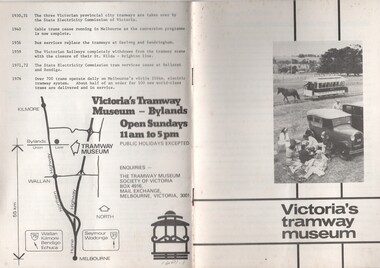 Melbourne Tram Museum
Pamphlet, Tramway Museum Society of Victoria (TMSV), "Victoria's tramway museum", mid 1970's to July 1982
... line history of Victoria's tramways and a location map... and a location map on the rear cover. See Reg Item 5151 for a print ...Set of two pamphlets or booklets, titled "Victoria's tramway museum", providing details of the Tramway Museum Society's TMSV collection, the site and its exhibits and a brief time line history of Victoria's tramways and a location map on the rear cover. See Reg Item 5151 for a print of the photograph that was cropped for the front cover. .1 - 12 pages -folded A5 size - white cover - centre stapled - has a photo of the Royal Park horse tram operating on the Bylands site - mid 1970's? See Reg Item 5151 for a print of the photograph that was cropped for the front cover. .2 - 12 pages - folded A5 size - blue cover, white sheets internally - centre stapled - has the TMSV logo on the front cover - late 1970's. .3 - as above, white cover with an tram front image on the front cover, has "Interim edition July 1983 - internal connects the same as .1.1601.2 - has a price lable of 20c on the front cover.trams, tramways, tmsv, bylands, museums, horse trams -
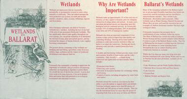 Ballarat Tramway Museum
Pamphlet, City of Ballarat, "Wetlands in Ballarat", early 1990s
... on the importance of the Wetlands, locations and a map. As well, provides.... Provides information on the importance of the Wetlands, locations ...The pamphlet provides information about the wetland areas in the Ballarat district, in particular the ones in the North Gardens Reserve and Lake Wendouree. Provides information on the importance of the Wetlands, locations and a map. As well, provides contact details for the Department of Conservation and Natural Resources and the City of Ballaarat. Based on the spelling of the City of Ballaarat pamphlet early 1990s.Yields information about the Ballarat's wetlands within in which the tramway museum operates.Pamphlet - 4 fold DL printed in red and green ink.city of ballarat, wetlands, lake wendouree, conservation -
Whitehorse Historical Society Inc.
Map, before 1890
... Early map showing location and areas of plots... to 1969 Early map showing location and areas of plots ...Early map showing location and areas of plots and their owners' names between Heatherdale Road in the east and Springvale Road in the west, Burwood Road to the south to north of Canterbury Road. Later additions to 1969Early map showing location and areas of plots and their owners' names between Heatherdale Road in the east and Springvale Road in the west, Burwood Road to the south to north of Canterbury Road. Later additions to 1969Early map showing location and areas of plots and their owners' names between Heatherdale Road in the east and Springvale Road in the west, Burwood Road to the south to north of Canterbury Road. Later additions to 1969mitcham, vermont, nunawading -
Glenelg Shire Council Cultural Collection
Document - Portland Tourism Brochure, National Parks Victoria, n.d
... DL flyer, fold out map showing location of National Parks... Cliff Street Portland great-ocean-road DL flyer, fold out map ...DL flyer, fold out map showing location of National Parks in Victoria with written description of each, plus photos of various flora and fauna, prefaced by brief history of national parks in Victoria. Full colour. -
 Eltham District Historical Society Inc
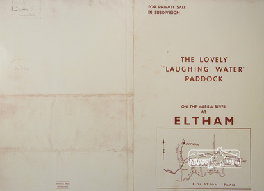
Photograph, For Private Sale in Subdivisions; The Lovely "Laughing Water" Paddock on the Yarra River at Eltham
... Collins Street, Melbourne Location plan and subdivision map... Collins Street, Melbourne Location plan and subdivision map ...Private sale of the "Laughing Water" paddock in subdivision; 5 river frontages with weatherboard villa on Lot 8; 6 woodland blocks of 5 and 6 acres. Sole Agent: Edward Haughton, 379 Collins Street, Melbourne Location plan and subdivision mapA3 colour photographic print from digital image of sales brochure and A4 reproduction of price listlaughing waters, edward haughton, real estate agent, eltham -
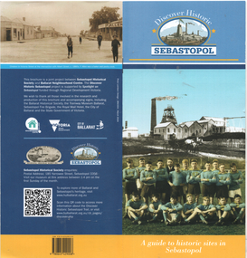 Ballarat Tramway Museum
Pamphlet, Sebastopol Historical Society, "Discover Historic Sebastopol", 2024
... in Sebastopol. Has a map of locations or sites of interest..." - a guide to historic sites in Sebastopol. Has a map of locations ..."Discover Historic Sebastopol" - a guide to historic sites in Sebastopol. Has a map of locations or sites of interest, introduction, includes notes on trams, Royal Mail Hotel and the last tram. Published by Sebastopol Historical Society and the Ballarat Neighbourhood Centre with design by Peter Lambert Design.Yields information about the history of the Sebastopol district.Pamphlet - 36 pages, colour stapled, DL size.sebastopol, local history, tramways -
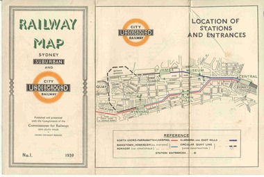 Ballarat Tramway Museum
Map, NSWGR, "Railway Map of Sydney Suburban and Underground" - 1939, 1939
... Light card or Heavy paper. Colour map showing location.... Colour map showing location of Sydney stations and entrances ...Light card or Heavy paper. Colour map showing location of Sydney stations and entrances and where the trains ran. Issued as No.1. Title "Railway Map of Sydney Suburban and Underground" - 1939. Handle with care - both copies.trams, tramways, sydney, railway map, suburban and underground, trams -
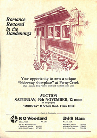 Melbourne Tram Museum
Document - Personal Papers, The Age, Keith Kings, Progress Press, Higgins Teale & Co, Herald Sun, house built using former PMTT tramcars, 1976 to 1983
... in. 5 - hand written note, with plan of the trams and location... of the trams and location map - not dated 6 - set of six hand written ...Collection of Personal Papers regarding a house built using former PMTT tramcars. Comprises: 1 - Auction notice - folded A3 light card, "Moonta 18 School Road Ferny Creek" - giving details of the property, agents, floor plan and auction date of 19/11/1983. Agents R. Woodard and D&S Ham (2 copies held) 2 - Newspaper clipping from the Progress Press with a sketch and article - "Home built from trams" 3 -"Fares please for tram treat" - Herald Sun, 24/9/1983. 4 -Auction notice - 21/11/1983 - property passed in. 5 - hand written note, with plan of the trams and location map - not dated 6 - set of six hand written notes recording conversations with various people regarding a house in Ferny Creek with trams, including the Public Trustee 1976 and 1977. 7 - Auction notice for "Charrawalla" - School Road, Ferny Creek dated 7/5/1977 from The Age. Not all items numbered, See also Reg Item 1356, 1833 and 1518 for related items.trams, tramways, mmtb, pmtt, ferny creek, tramcars, melbourne, houses, sale of land -
Clunes Museum
Map, DEPARTMENT OF MINES, Untitled, c1859
... All maps show names and locations of mines operating....1 Map of Creswick Clunes - lists 45 mines in the Clunes...All maps show names and locations of mines operating ...All maps show names and locations of mines operating in the district (see reference section link to article).1 Map of Creswick Clunes - lists 45 mines in the Clunes enlargement and 100 mines in the Creswick enlargement .2 Department of Mines map of Clunes Creswick and shows the McDonald & Co. Pre-emptive area. Indexes for quartz and alluvial mine locations .3 Topographical map Ref GF23 Clunes Mt. Greenock Talbot.1 360 Scale 1:2500 .2 303/59 33 hand written in ink "received 15 October 1859" signed by R Broughton, James Stevenson - District Mining Surveyor .3 40 chains to an Inchgold mining, dept of mines -
 Victorian Aboriginal Corporation for Languages
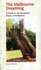
Book, Meyer Eidelson, The Melbourne dreaming : a guide to the Aboriginal places of Melbourne, 1997
... remains of Aboriginal activity before settlement. Locations have.... Locations have been mapped and Melways references and maps ...This guide shows Melbourne?s Aboriginal places so that people using it can gain easy access to and a greater knowledge of them. Important historical events occurred at some of them. Others are Archaeological sites where there are still physical remains of Aboriginal activity before settlement. Locations have been mapped and Melways references and maps are included.maps, b&w illustrations, colour illustrations, colour photographs, word listswoi wurrung, wurundjeri, boon wurrung, kulin, yarra yarra, yarra river, werribee river, bunjil, waa, moieties, maribyrnong, sacred sites -
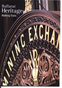 Ballarat Tramway Museum
Book, City of Ballarat, "Ballarat Heritage Walking Trails", 2010
... or locations. Has a map in the centre pages. The walking trails... of the buildings or locations. Has a map in the centre pages ...Booklet - 36 pages, full colour photographs, titled "Ballarat Heritage Walking Trails", providing details of three heritage walking trails around the central portion of Ballarat. Gives a short description and photograph of the buildings or locations. Has a map in the centre pages. The walking trails: CBD Heritage Lydiard St Heritage Sturt St statuetrams, tramways, lydiard st, sturt st, ballarat, heritage