Showing 1403 items
matching lower plenty, main road
-
 Eltham District Historical Society Inc
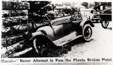
Photograph, Moral - "Never attempt to pass the Plenty Bridge Hotel"
... melbourne lower plenty bridge main road lower plenty bridge ...Black and white photograph of a newspaper story about an accident at Lower Plenty Bridgelower plenty, bridge, main road, lower plenty bridge, transport, automobile, accident -
 Eltham District Historical Society Inc
Film - Video (VHS), Dynavision Video Production, 1994 Eltham Festival, 11 Nov 1994
... , Lower Plenty Primary School, Main Road, Montmorency Gardening..., Lower Plenty Primary School, Main Road, Montmorency Gardening ...20th Eltham Community Festival and last under the auspices of the Shire of Eltham. The Grand Parade focussing on the theme "Echoes of Eltham - Celebrating the visions of Eltrham from the past and into the future" was headed by Jock Read on his horse Lofty who had been filmed in an Anzac Day Parade on an earlier horse which had featured in the television show Matlock. The parade travelled north along Main Street to just past the Post Office then back south to Panther Place. Parade participants included 1st Eltham Brownies, 1st Eltham Venturers, 2nd Eltham Sea Scouts, 2nd Eltham Venturers, 3rd Eltham Brownies, Australian Democrats, Briar Hill Primary School, Circus Chaos, Country Fire Authority, Diamond Valley People for Disarmament, Diamond Valley Railway, Eltham Community Health Centre, Eltham District Horse and Pony Club, Eltham East Primary School, Eltham Fire Brigade, Eltham Junior Football Club (Panthers), Eltham Little Theatre, Eltham North Primary School, Eltham Playhouse Co-op, Eltham Pre-school, Eltham Roller Skating Club, Eltham South Pre-School Centre, Eltham Steam and Stationary Engine Society, Greenhills Neighbourhood House, Heidelberg Municipal Band, Hurstbridge Learning Co-op, Jocklebeary Farm, Kangaroo Ground Primary School, Learning Co-op Primary School, Lower Plenty Primary School, Main Road, Montmorency Gardening Club, Montmorency South Primary School, North Warrandyte Fire Brigade, Plenty Valley 88.6 FM, Research Pre-school, Research Primary School, Ron Sampson, Salvation Army Band (Briar Hill), Sherbourne Primary School, Shire of Eltham, State Emergency Service (Eltham) and Woodridge Pre-school. The parade commentary was provided by Plenty Valley FM 88.6 with guest commentator, Shire President Cr. John Graves. Following the parade is video footage from a helicopter of Alistair Knox Park, displays along Main Road and activities in Alistair Knox Park and the Rugby oval along with stationary engines, helicopter joyrides, Eltham People's Choir, music entertainment. Scenes also from the Diamond Valley Railway at Eltham Lower Park and finishing with the fireworks display. At the end of the video is a promotional video for Dynavision Video Production, a local video production company that produced the video and Diamond Photos (Kodak Express). One of the highlights of the festival was a tree planting ceremony in Alistair Knox Park to celebrate 123 years of the Shire of Eltham led by Shire President Cr. John Graves and representatives of the Wurrundjeri, traditional land owners of the area.VHS Video cassette (poor quality) Converted to MP4 file format 45:01, 535MB DVD copy of VHS cassette (better quality)1st eltham brownies, 1st eltham venturers, 2nd eltham sea scouts, 2nd eltham venturers, 3rd eltham brownies, 1994, aerial photographs, alistair knox park, arthur street, australian democrats, briar hill primary school, circus chaos, country fire authority, diamond valley people for disarmament, diamond valley railway, eltham community health centre, eltham district horse and pony club, eltham east primary school, eltham festival, eltham fire brigade, eltham junior football club (panthers), eltham little theatre, eltham lower park, eltham north primary school, eltham people's choir, eltham playhouse co-op, eltham pre-school, eltham roller skating club, eltham south pre-school centre, eltham steam and stationary engine society, grand parade, greenhills neighbourhood house, heidelberg municipal band, hurstbridge learning co-op, jock read, jocklebeary farm, john graves, kangaroo ground primary school, learning co-op primary school, lofty (horse), lower plenty primary school, main road, matlock police (tv show), montmorency gardening club, montmorency south primary school, nicholaus lauder estate, north warrandyte fire brigade, plenty valley 88.6 fm, research pre-school, research primary school, ron sampson, salvation army band (briar hill), sherbourne primary school, shire of eltham, state emergency service (eltham), video recording, woodridge pre-school -
 Eltham District Historical Society Inc
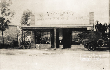
Photograph, C.D. Stewart Lower Plenty Post Office and Store, 1920s
... melbourne post office shops lower plenty c.d stewart main road Black ...Black and white photograph of post office store, Lower Plenty, C D Stewart proprietor c.1920s.post office, shops, lower plenty, c.d stewart, main road -
 Eltham District Historical Society Inc
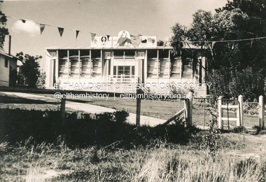
Photograph, Decorations for Queen Elizabeth II Coronation celebrations, Lower Plenty State School No. 1295, c. June 1953
... Bristol classrooms schools lower plenty bristol classroom main ...Lower Plenty Prinary School decorated for Queen Elizabeth II's Coronation celebrations in Victoria. Shows the newer style Bristol classroomsBlack and white photograph of Bristol portable classroom at Lower Plenty School No. 1295Source: School at the crossing place, W.F. Hendersonschools, lower plenty, bristol classroom, main road, coronation, lower plenty state school no. 1295 -
 Eltham District Historical Society Inc
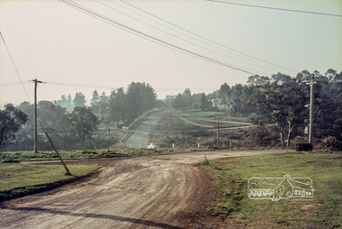
Photograph, Russell Yeoman, Para Road, c.1969, 1969c
... Looking north from behind the Lower Plenty shops at Main... melbourne Looking north from behind the Lower Plenty shops at Main ...Looking north from behind the Lower Plenty shops at Main Road and Para Road.Digital file only; created from original colour positive slide transparencystreets, lower plenty, para road, russell yeoman collection -
 Greensborough Historical Society
Photograph - Digital image, Edward Henry Blackbourn, 1920c
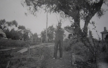
... Edward Henry Blackbourn, taken at 155 Main Road Lower... at 155 Main Road Lower Plenty with Main Road in background ...Edward Henry Blackbourn, taken at 155 Main Road Lower Plenty with Main Road in background. Photographs from the collection of Peter Blackbourn, a descendant of the Chapman Stock family. Annotations to photos by Peter Blackbourn.Digital copy of black and white photograph.peter blackbourn, edward henry blackbourn -
 Eltham District Historical Society Inc
Photograph, Fay Bridge, Rosehill Homestead, EDHS Heritage Excursion, 6 July 2019
July Excursion July 6, 2019 - Exploring Lower Plenty The predominant feature of this walk in the Bonds Road area, Lower Plenty is the large number of magnificent old River Red Gums that line the route. These trees are of the spreading woodland form of this species indicating that they must have been originally growing in a reasonably open setting. The walk also includes parts of the historic Cleveland Estate and the homestead “Rosehill” established by pioneer farmer Henry Stooke. This area was the site of the first recorded European settlement in what was to become the Shire of Eltham when the Willis brothers arrived in the late 1830s. From the southern part of Cleveland Avenue there are extensive views across and along the Yarra Valley. An article on the history of this area was contained in Newsletter edition 201, November 2011. The walk will start at the at the corner of Bonds and Stawell Roads, Lower Plenty - EDHS Newsletter No. 246 June 2019fay bridge collection, 2019-07-06, blackburn bricks, eltham district historical society, heritage excursion, rosehill homestead, lower plenty -
 Eltham District Historical Society Inc
Photograph - Aerial Photograph, Landata, Lower Plenty, Feb. 1956
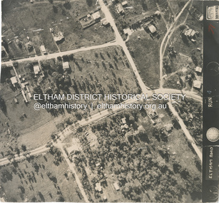
... melbourne Centred on present day 217 Old Eltham Road, Lower Plenty ...Centred on present day 217 Old Eltham Road, Lower Plenty bounded by Pitt Street to north, Yarra River to south, Main Road to east and Bonds Road to west. Historic Aerial Imagery Source: Landata.vic.gov.au Aerial Photo Details: Project No :250 Project : MELBOURNE OUTER SUBURBS PROJECT Run : 17 Frame : 116 Date : 02/1956 Film Type : B/W Camera : EAG9 Flying Height : 10000 Scale : 12000 Film Number : 1176 GDA2020 : 37°43'58"S, 145°07'49"E MGA2020 : 335237, 5822186 (55) Melways : 21 E10 (ed. 42)aerial photo, 1956-02, neil webster collection, eltham, main road, bonds road, elham, lower plenty, melway 21e10, pitt street, yarra river -
 Eltham District Historical Society Inc
Photograph - Aerial Photograph, Main Road, intersection Grand Boulevard and Panorama Avenue, Lower Plenty / Montmorency, 2 Jul. 1951
Not originally catalogued in Shire of Eltham Archives but from the same series of photos taken for Country Road Board study of Main Road wideningshire of eltham archives, aerial photo, country roads board, eltham, main road, road widening, 1951-07, airlie road, ambulance station, beleura grove, grand boulevard, looker road, lower plenty, montmorency, panorama avenue -
 Eltham District Historical Society Inc
Newspaper - Advertising, The Advertiser, Nillumbik Festival In Pictures; pp5-7, November 14, 1995
... for the Panthers in Main Road Eltham Lionesses Marcia Whitely, Peggy Lear... for the Panthers in Main Road Eltham Lionesses Marcia Whitely, Peggy Lear ...The Nillumbik Festival was introduced as a replacement for the Eltham Festival following the disbandment of Eltham Shire Council in December 1994 and the creation of Nillumbik Shire Council. It was an attempt to draw away from Eltham and be more inclusive of the wider communities in Nillumbik. However other local communities had their own festivals and the concept of a Nillumbik Festival was never widely accepted by the community and it shortly reverted back to the Eltham Fesitval in 1997. Page 5 Photo: Acting Sen-Sgergeant Paul MacNicholl of Eltham Police with Jamie-Lee Teagley and friends at the Nillumbik Festival on Saturday Page 6 Photos: Nillumbik Chief Don Cordell with Parade leader Jock Read & Lofty Roma O'Callaghan and Brian McKean of Plenty Valley FM - 88.6 Artist Ray Macminn of Diamond Valley arts Society exhibition The Eastside Jazz Band lead the way in Saturday's Nillumbik Festival Eltham Football Club fellas fly the flag for the Panthers in Main Road Eltham Lionesses Marcia Whitely, Peggy Lear, June Cook & Kath Elliott ALP's Sherryl Garbutt, Harry Jenkins, Sig Jorgensen and Jenny Macklin Diamond Valley Arts Society's Don Cook paints with oils on Saturday It's amaxing who'll you'll meet at the Nillumbik Festival Page 7 Photos: Eltham MLA Wayne Phillips with Jaga Jaga candidate Michelle Penson Greens candidate Julie Coulston with Geraldine Ryan at Knox Park The Anti Ring Road Organisation march on, you guessed it, Main Road Lower Plenty Primary School had an imaginative display in the Parade The Melbourne Kyokushin Club show their defence skills on Saturday Brian Harvey of Diamond Valley Sports Complex at the Fitness Expo Michael Jerrard and president Trevor Taylor of Greensborough- Diamond Creek Apex Jock Kyme drives the Democratic Nillumbik Association float on Main Road Page 8: Letter: Time for a new Eltham Festival by Sigmund JorgensenNewsprint1995, eltham festival, nillumbik festival, 1st eltham brownies, 1st eltham scouts, alistair knox park, allwood house belly dance, anti ring road organisation (arro), brian mckean, circus of chaos, democratic nillumbik association, diamond valley people for nuclear disamament, don cordell, drum group, eastside jazz band, eltham cfa, eltham community health centre, eltham east primary school, eltham fire brigade, eltham football club juniors, eltham north primary school, eltham primary school, eltham ses, eltham south primary school, eltham steam and stationary engine society, grand parade, harry jenkins, jean austin, jenny macklin, jock read, john cust, john huf, julie coulston, kevin abbott, kevin austin, lofty (horse), lower plenty primary school, lyn allison, main road, melbourne kyokushin karate school, montmorency garden club, montmorency south primary school, montsalvat coachlines, nillumbik commissioners, nillumbik garden club, north warrandyte fire brigade, panther place, peter burton, plenty valley 88.6 fm, pryor street, rats of tobruk memorial pipes and drums, research fire brigade, research primary school, robert guy, roma o'callaghan, sheryl garbutt, sigmund jorgensen, tim newhouse, wayne phillips m.p., woodridge pre-school, diamond valley vineyards, dutch social club, edendale community farm, eltham bowling club, eltham eagles in-line hockey, eltham football club, eltham rugby football club, eltham vineyards, ginger garlic, kingstan berries, silvie's delectables, vili's pies, wycliffe bible translators -
 Eltham District Historical Society Inc
Photograph, Liz Pidgeon, Public Records Office Victoria (PROV) visit to Eltham Justice Precinct, 20 Apr 2018
The original Shire of Eltham was founded in 1871. Prior to its founding, the district was managed by the Eltham District Road Board, which was established in 1856. The initial rate assessment commenced in 1857 for the year ending October 14, 1858. The honour of being recorded with the first assessment went to a farm of 110 cultivated acres at Lower Plenty, owned by John Porter and occupied by Albert Baines. It was assessed at 6d/acre providing for a rate income of £2 15s. In July 2017, officers at Nillumbik Shire Council discovered some early Eltham Road District Assessment books and donated them to the Eltham District Historical Society. The seven volumes were the district’s first six years of rate assessments. This was a unique and significant record of early settlers in the pre-Shire of Eltham. They immediately became one of the oldest and most valuable items in our collection. An article on page 5 in the Eltham and Whittlesea Shires Advertiser, Friday, 21 November, 1941 titled: ‘District’s Early History‘ states: “The first rate book which is still in existence at the Shire Office is for the year ending October 14, 1858 and is probably the best record possible to indicate the development of the district. At the time properties were rated as follows: Cultivated land. 6d. per acre; pasture land, 1d. per acre: estimated annual value of buildings, etc., 6d in the (pound). The total amount of rate recorded for the year was £153/14/8. Properties were described as being situated at Lower Plenty, Yarra Yarra, Eltham, Lower Eltham, Kangaroo Ground, Yarra Flats, Diamond Creek and the Yarra.” Given the precious nature of this collection, priority was given to digitise the rate books and place them in suitable archival storage to minimise further handling. Subsequent discussion amongst our Collections team arrived at the conclusion that the most appropriate home for this valuable record was the Public Record Office Victoria (PROV), the archive of the State Government of Victoria and who are charged with archiving and caring for all Government related records. An approach was made to PROV who confirmed these records would complete their collection of rate assessment books for Eltham. At a small ceremony held Friday, April 20 at the Local History Centre, Eltham, members of the Society and our Collections team, along with Ms. Vicki Ward, MP for Eltham, presented the seven volumes for 1858-1863 along with the complete set of digital files to Mr. David Taylor, Community Archives Manager and Mr. Charlie Farrugia, Senior Collection Advisor, Public Record Office Victoria.Born Digitalassessment ledger, donation, eltham courthouse, eltham road district, local history centre, public records office victoria (prov), rate books, eltham district road board -
 Eltham District Historical Society Inc
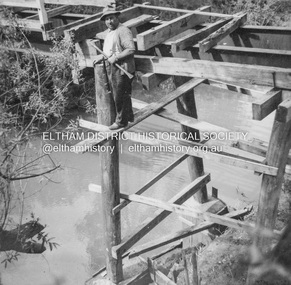
Album - Photograph, J.A. McDonald, Eltham-Yarra Glen Road, 18 Oct. 1956
Eltham-Yarra Glen Road Proposed crossing of Plenty River at Lower Plenty. Floods 18th October 1956.Record of various Shire of Eltham infrastructure works undertaken during the period of 1952-1962 involving bridge and road reconstruction projects, sometimes with Eltham Shire Council Project Reference numbers quoted. It was during this period that a number of significant improvements were made to roads and new bridges constructed within the shire that remain in place as of present day (2022). In many situations, the photos provide a tangible visible record of infrastructure that existed throughout the early days of the Shire. The album was put together by or under the direction of the Shire Engineer, J.A. McDonald.infrastructure, road construction, shire of eltham, bridge construction, eltham-yarra glen road, 1956-10-18, floods, floodwater, lower plenty, plenty river -
 Eltham District Historical Society Inc
Album - Photograph, J.A. McDonald, General; Albion Street and Eltham-Yarra Glen Road, Oct. 1955
Eltham-Yarra Glen Road Lower Plenty Footbridge October 1955 (Jolly)Record of various Shire of Eltham infrastructure works undertaken during the period of 1952-1962 involving bridge and road reconstruction projects, sometimes with Eltham Shire Council Project Reference numbers quoted. It was during this period that a number of significant improvements were made to roads and new bridges constructed within the shire that remain in place as of present day (2022). In many situations, the photos provide a tangible visible record of infrastructure that existed throughout the early days of the Shire. The album was put together by or under the direction of the Shire Engineer, J.A. McDonald.infrastructure, road construction, shire of eltham, 1955-10, bridge construction, eltham-yarra glen road, lower plenty footbridge -
 Eltham District Historical Society Inc
Document - Property Binder, Main Road
... melbourne Main Road Lower Plenty Eltham Research (Vic) Property ...main road, lower plenty, eltham, research (vic), property, houses, shops, businesses, montmorency -
 Eltham District Historical Society Inc
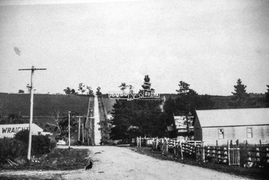
Document - Property Binder, Plenty River Bridge, Main Road, Lower Plenty
... Plenty River Bridge, Main Road, Lower Plenty..., Main Road, Lower Plenty Document Property Binder ...Extracts Heidelberg Council Minutes re Plenty Bridge, 3 September1862, 10 May 1865, 22 May 1865, 5 June 1865 , 10 October1866, 14 November1866, 13 February 1867.main road, property, houses, shops, businesses, plenty bridge -
 Eltham District Historical Society Inc
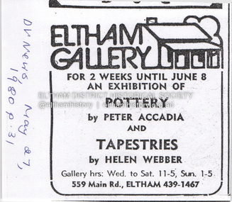
Document - Property Binder, 559 Main Road, Eltham
... 410 Main Road Lower Plenty... Montmorency 410 Main Road Lower Plenty Abbey of Diamond Creek Adams ...Newspaper advertisement: Diamond Valley News, 27 May 1980, Exhibition, Peter Accadia, pottery, and Helen Webber, tapestries. Newspaper article: Five for the price of one, Diamond Valley News, Tuesday, July 8, 1986, p27; exhibition of five artists at Eltham Gallery. On reverse, numerous advertisements for food and entertainment Newspaper advertisement: The Age ,17 June 1989, Exhibition, Donald Ramsay "Watching the river flow". Newspaper article: Landmark gallery says goodbye, Diamond Valley Leader, 24 November 2004, Gallery site sold to Sentinel Equities, present tenant Julie Skate, quotes from former part-owner Val Murray. Newspaper article: Rift over gallery plans, Diamond Valley Leader, 21 February 2007, purchasers Jethro Tull and Suzanne Still plan to build offices, gallery and cafe; Eltham Gateway Action Group objected while supporting need for a gallery elsewhere. Newspaper article: New try for gallery-cafe ready soon, Diamond Valley Leader, 18 April 2007, purchaser Jethro Tull to have a new plan ready in two weeks for gallery and cafe. Newspaper article: Gateway for artists, Diamond Valley Leader, 25 May 2007, Jenni Mitchell opened a new gallery pending decision by Nillumbik Council. Newspaper article: Art gallery proposal rejected, Diamond Valley Leader, 30 May 2007, Nillumbik Council against planned new building. Newspaper article: Artful win for gallery, Diamond Valley Leader, 30 January 2008, VCAT approved mudbrick art gallery. Newspaper article: Rocky road to create a landmark, Diamond Valley Leader, 13 February 2008, VCAT approved Robert Marshall's design, artists's impression, Eltham Gateway Action Group opposed.main road, property, businesses, eltham gallery, wiregrass gallery, eltham gateway action group, robert marshall, mud brick building, eltham (vic), 559 main road eltham, artists, bernhard rust, bob smith, jan neil, john adams, marian sussex, michael wilson, tony dopheide, 47-55 main street diamond creek, 50 were street montmorency, 55 rattray road montmorency, 410 main road lower plenty, abbey of diamond creek, adams north riding restaurant, advertising, eltham barrel, montmorency, mustard seed restaurant, peking house restaurant, st andrews, tamara's -
 Eltham District Historical Society Inc
Negative - Photograph, J.A. McDonald, Eltham-Yarra Glen Road, Lower Plenty, c. July 1962
View looking west across the Eltham-Yarra Glen Road approaching the Lower Plenty Bridge near turn-off for the Golf Club Hotel. Present-day Lower Plenty Road follows a revised alignment across a new bridge. The former bridge is now part of the Plenty River Trail and Edward Willis Court now follows this section of the original Eltham-Yarra Glen Road.. The Golf Club Hotel is gone and a new Lower Plenty Hotel was built slightly further up the hill.Record of various Shire of Eltham infrastructure works undertaken during the period of 1952-1962 involving bridge and road reconstruction projects, sometimes with Eltham Shire Council Project Reference numbers quoted. It was during this period that a number of significant improvements were made to roads and new bridges constructed within the shire that remain in place as of present day (2022). In many situations, the photos provide a tangible visible record of infrastructure that existed throughout the early days of the Shire. The album was put together by or under the direction of the Shire Engineer, J.A. McDonald.1962-07, shire of eltham, old eltham road, edward willis court, eltham-yarra glen road, golf club hotel, infrastructure, lower plenty, road construction -
 Eltham District Historical Society Inc
Slide - Photograph, Unidentified location, Eltham district, c.Aug. 1990
Part of a presentation, "Roads and Byways of the Shire of Eltham", by Russell Yeoman to the 12 September 1990 Society meeting. Slides shown included copies of old photos and recent images ranging from the suburban streets of Eltham and Montmorency to the mountain roads of Kinglake. In the byways category are views of some iof the Shire's bicycle paths including then recently completed sections of the Main Yarra Trail at Lower Plenty.35mm colour positive transparency (1 of 37) Mount - Agfachrome Agfa CS System black 8 dotseltham, infrastructure, roads, unidentified -
 Eltham District Historical Society Inc
Slide - Photograph, Near the old Lower Plenty Bridge (present day Edward Willis Court), c.Aug. 1990
Part of a presentation, "Roads and Byways of the Shire of Eltham", by Russell Yeoman to the 12 September 1990 Society meeting. Slides shown included copies of old photos and recent images ranging from the suburban streets of Eltham and Montmorency to the mountain roads of Kinglake. In the byways category are views of some iof the Shire's bicycle paths including then recently completed sections of the Main Yarra Trail at Lower Plenty.35mm colour positive transparency (1 of 37) Mount - Agfachrome Agfa CS System black 8 dotsinfrastructure, roads, edward willis court, lower plenty, lower plenty bridge -
 Eltham District Historical Society Inc
Slide - Photograph, Main Road, Eltham, c.1910, c.Aug. 1990
... then recently completed sections of the Main Yarra Trail at Lower Plenty ...Part of a presentation, "Roads and Byways of the Shire of Eltham", by Russell Yeoman to the 12 September 1990 Society meeting. Slides shown included copies of old photos and recent images ranging from the suburban streets of Eltham and Montmorency to the mountain roads of Kinglake. In the byways category are views of some iof the Shire's bicycle paths including then recently completed sections of the Main Yarra Trail at Lower Plenty.35mm colour positive transparency (1 of 37) Mount - Agfachrome Agfa CS System black 8 dotsinfrastructure, roads, main road, eltham -
 Eltham District Historical Society Inc
Slide - Photograph, Eltham-Yarra Glen Road, Kangaroo Ground c.1910, c.Aug. 1990
Part of a presentation, "Roads and Byways of the Shire of Eltham", by Russell Yeoman to the 12 September 1990 Society meeting. Slides shown included copies of old photos and recent images ranging from the suburban streets of Eltham and Montmorency to the mountain roads of Kinglake. In the byways category are views of some iof the Shire's bicycle paths including then recently completed sections of the Main Yarra Trail at Lower Plenty.35mm colour positive transparency (1 of 37) Mount - Agfachrome Agfa CS System black 8 dotsinfrastructure, roads, eltham-yarra glen road, kangaroo ground -
 Eltham District Historical Society Inc
Slide - Photograph, Unidentified location, Eltham district, c.Aug. 1990
Part of a presentation, "Roads and Byways of the Shire of Eltham", by Russell Yeoman to the 12 September 1990 Society meeting. Slides shown included copies of old photos and recent images ranging from the suburban streets of Eltham and Montmorency to the mountain roads of Kinglake. In the byways category are views of some iof the Shire's bicycle paths including then recently completed sections of the Main Yarra Trail at Lower Plenty.35mm colour positive transparency (1 of 37) Mount - Agfachrome Agfa CS System black 8 dotsinfrastructure, roads, houses, private street scheme, residential, unidentified -
 Eltham District Historical Society Inc
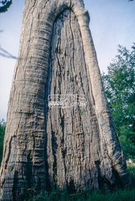
Slide - Photograph, Scar tree, Lower Plenty, c.Apr. 1993
Possibly near Bonds Road Lower Plenty35mm colour positive transparency (1 of 22) Mount - Kodak EktachromeProcess Date "Apr M"significant tree, lower plenty, scar tree -
 Eltham District Historical Society Inc
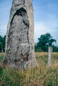
Slide - Photograph, Scar tree, Lower Plenty, c.Apr. 1993
Possibly near Bonds Road Lower Plenty35mm colour positive transparency (1 of 22) Mount - Kodak EktachromeProcess Date "Apr M"significant tree, lower plenty, scar tree -
 Eltham District Historical Society Inc
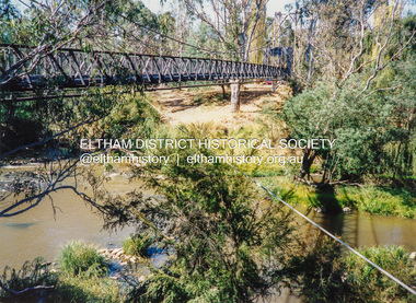
Photograph - Colour Print, Pedestrian suspension bridge over the Yarra River at Lower Plenty, c.1987
blessed sacrament fathers, bonds road, bridge, footbridge, lower plenty, odyssey house, seminary, yarra river -
 Eltham District Historical Society Inc
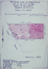
Slide - Photograph, Eltham Shire Council, Tentative Plan of Subdivision of Part of Lot 4 on L.P. 44 686, Parish of Nillumbik, County of Evelyn, 1969
35mm colour positive transparency blue Agfacolour Service plastic mountB3 Robinson prelim subdivision, View Road, 4 August 1969infrastructure, map, planning, subdivison lots, view road, rosehill road, lower plenty -
 Eltham District Historical Society Inc
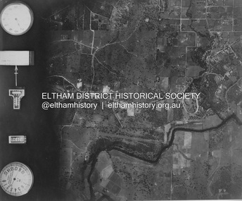
Photograph - Aerial Photograph, Landata, Eltham and Lower Plenty, Nov. 1931
Centred over present-day Rosehill Road and View Road, Lower Plenty Historic Aerial Imagery Source: Landata.vic.gov.au Aerial Photo Details: Project No :1931 Project : MALDON PRISON Run : 19 Frame : 3129 Date : 11/1931 Film Type : B/W Camera : F8 Flying Height : 11000 Scale : 18860 Film Number : 60 GDA2020 : 37°44'16"S, 145°07'40"E MGA2020 : 335039, 5821622 (55) Melways : 21 E11 (ed. 42)aerial photo, eltham, lower plenty, neil webster collection, rosehill road, view road -
 Eltham District Historical Society Inc
Photograph, Neville F. Emerson, Shoestring, Metery Road, Eltham, n.d
Stamped on reverse: Neville F. Emerson Estate Agent 81 Main Rd., Lower Plentyeltham, metery road, neville f. emerson real estate (lower plenty), shoestring, houses