Showing 1585 items
matching lundy-clarke
-
 Mt Dandenong & District Historical Society Inc.
Photograph
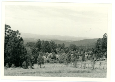
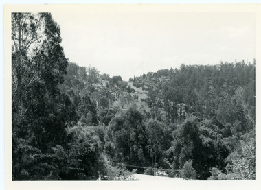
In 1913 Edgar Dower took a photograph from this spot on Ridge Road that became known as Point Clear showing the Mt Dandenong township behind a stand of tall, dead trees. John Lundy-Clarke took this photograph from a similar spot at the Mt Dandenong Arboretum in 1975.Black and white photograph showing a cleared area in the foreground with young tress in the centre and hills in the distance. Several rooftops can be seen mid photo on the right. Reverse of photograph has handwritten description by John Lundy-Clarke.1975 View from the Arboretum over Mt D'nong township at the spot where Edgar Dower took the 1913 photo. The Falls gully is in the middle distance. Peter Damman's fence running downhill right foreground.edgar dower, point clear, mt dandenong, john lundy-clarke, peter damman, arboretum -
 Mt Dandenong & District Historical Society Inc.
Photograph, View of Kalorama Gap 1905
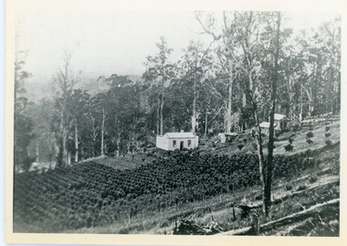
Kalorama Gap viewed from the South West in 1908. Ellis Jeeves' 'Mountjoy' is in the centre with the stables to the left. The raspberry patch belongs to Harry Walker and the building centre right to Edward Joseph Price. John Lundy-Clarke grew up in the Kalorama/Mt Dandenong area and later in life (1972-74) began to write a comprehensive history of the area working from an original settlement map in an effort to cover all areas.Black and white photograph showing an extensive raspberry crop in the foreground with a house and outbuilding in the centre and another dwelling centre right. Handwritten description on reverse by John Lundy-Clarke. 1908 view of Kalorama Gap taken from corner of Village Settlement LOTS 2 and 3 on Ridge (then Main Road) which crosses centre of picture with Walker’s driveway dropping left. Walker’s raspberry patch in foreground. “Mountjoy” in centre of picture with coaching stables on left. Price’s house and shop on right showing large cross room used by the Village Settlers for dancing. Mrs Hand’s “Beulah Tearooms” later Mt Dandenong North Post Office is above Price’s roof.kalorama gap, kalorama, harry walker, walker, edward joseph price, raspberry, mountjoy -
 Mt Dandenong & District Historical Society Inc.
Photograph, Walker's LOT 2
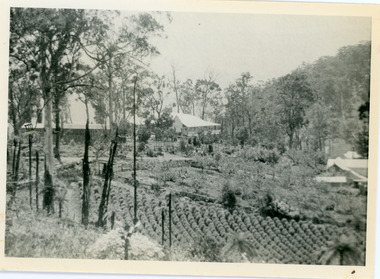
Lot 2 was bought by Harry Walker in the early 1900s. Harry was married to Eva Hand, one of the six daughters of Thomas and Eliza Hand. Harry cleared the land and planted half with raspberries that remained productive until c1928. Harry's son William took over the property. The land was cut in half when the new CRB road went through in the early 1920s. John Lundy-Clarke grew up in the Kalorama/Mt Dandenong area and later in life (1972-74) began to write a comprehensive history of the area working from an original settlement map in an effort to cover all areas.Black and white photograph showing a single storey white house in the centre surrounded by crops. Handwritten description on reverse by John Lundy-Clarke.VIEW 1908 OVER LOT 2 SECTION 1 VILLAGE SETTLEMENT. TAKEN FROM RIDGE ROAD THEN MAIN ROAD FROM HALFWAY BETWEEN MOUNTJOY AND FALLS RD. CRB MAIN RD RUNS BEHIND WALKER’S HOUSE. The house seen in the vista among the tall trees beyond the raspberry patch is “Forest Edge” which was George Barber’s home when the picture was taken. The tall trees to the right of the vista were on Price’s LOT 18 and it was while cutting up one of these for firewood that a length of log weighing about ½ a ton got away downhill and leaped in one bounce over Barbers Road and Logan’s house – 1931.harry walker, william walker, eva hand, crb road, raspberries, kalorama -
 Mt Dandenong & District Historical Society Inc.
Photograph, Site of Jeannie Richardson's Home 1973
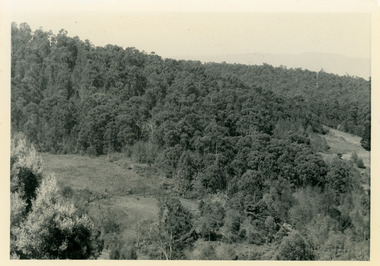
John Lundy-Clarke grew up in the Kalorama/Mt Dandenong area and later in life (1972-74) began to write a comprehensive history of the area working from an original settlement map in an effort to cover all areas. It was in the clearing on the left that John William (Willie) Richardson built a home for his wife Jeanie Green. It was called Mount Calvin. Jeanie was often ill and the family left the area seeking a warmer climate. They eventually settled in Brisbane. Willie sold the home and 60 acres around it to W. Rowse. Jeanie died in 1916. The remainder of the land was sold by solicitors to cover debts. Black and white photograph showing a treed hillside with a cleared area to the left hand side. Handwritten inscription on reverse by John Lundy-ClarkeLooking towards the site of Jeannie's home from near Doughty’s Road Nov 1973. Her house was in the centre of the clearing on the left. Photo Jan 1974 JLC.mount calvin, jeannie richardson, jeanie green, john william richardson, willie richardson, jeanie richardson, rowse -
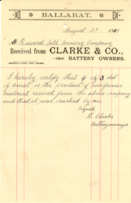 Federation University Historical Collection
Ephemera - Document, Wightwick and Wright, Clarke & Co. Battery Owners Invoice, 1910
Printed invoice from Clarke and Co., Battery Owners to reward Gold Mining Company.clarke and co, battery, wighwick and wright, h. clarke, mining, assay -
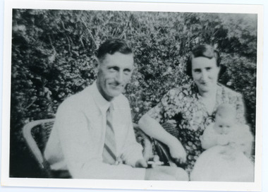 Mt Dandenong & District Historical Society Inc.
Photograph
The Wenborn family acquired Ferguson's Lot 19 of the Village Settlement where the original Mount Dandenong School was opened in a shed. WH Collom owned the land after Ferguson and then it passes to the Wenborns. This photograph shows Jim Wenborn with his wife Ivy and daughter Mary. The Wenborns had another daughter, Joan. Both children attended Mt Dandenong State School. John Lundy-Clarke grew up in the Kalorama/Mt Dandenong area and later in life (1972-74) began to write a comprehensive history of the area working from an original settlement map in an effort to cover all areas.Black and white photograph showing a man and woman seated in a garden. The woman is holding a small baby. Handwritten inscription on reverse by John Lundy-ClarkeJim Wenborn and family.wenborn, jim wenborn, ivy wenborn, mary wenborn, joan wenborn, ferguson, wh collom, mt dandenong school -
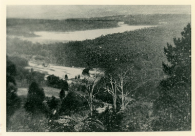 Mt Dandenong & District Historical Society Inc.
Photograph, Harmony Vale 1933
John Lundy-Clarke grew up in the Kalorama/Mt Dandenong area and later in life (1972-74) began to write a comprehensive history of the area working from an original settlement map in an effort to cover all areas. Harmony Vale was the name of the homestead built by early pioneer Jabez Richardson. The whole of the valley took on this name. The building lasted until 1933. The Silvan Dam was completed in 1932 and was full when this photograph was taken.Black and white photograph looking down over a forested area with a dam in the background. Copied from a Rose Series postcard c1933. Handwritten inscription on reverse by John Lundy-ClarkeRose Series photo of 1933 showing “Harmony Vale” still standing. Copied 1973 JLCharmony vale, silvan dam, jabez richardson -
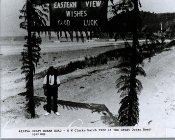 Lorne Historical Society
Photograph, G.W. Clarke with banner at Eastern View
Photograph 1922 of Mr G.W. Clarke under a banner reading " Eastern View Wishes Good Luck" g.w. clarke; 1922: eastern view wishes good luck banner; -
 Phillip Island and District Historical Society Inc.
Photographs, Early 20th Century
See history of the Clarke family on Register 325-11.325-16 - Sepia photograph of three men talking on the ferry Alvina. Jack Spaven on the left, Mr Candy talking to Cpt Jimmy Clarke in the background. Taken 1930's. 325-17 - Small sepia photograph of Captain Jimmy Clarke. 325-18 - Sepia photograph of Captain George Clarke. 325-19 - Sepia photograph of three people on the S.S.Alvina. Captain Jimmy Clarke on the right, adjusting the gangway. Other people unknown. 325-20 - Sepia photograph in solid cardboard mount of the Clarke homestead in San Remo, Victoria. 325-21 - Small sepia photograph of Jack Clarke in 1901. 325-22 - Black & White photograph of Violet and Jack Clarke. Violet was Jack & Jimmy's sister.Some inscriptions written on by Arthur Woodley. 325-16 - "Taken in the 1930's, Mr Candy talking to Captain J. L. Clarke on "Alvina", Jack Spaven on left. 325-18 - "Daddy on way home at San Remo" - Capt. G. P. Clarke at San Remo. 325-19 - "Captain Jimmy Clarke, right, adjusting the gangway on S. S. Alvina 1920's - other people not known". 325-20 - "Our old home at San Remo". "Clarke's old home". "Home of Captain George Clarke. He dies 1904" 325-21 - "In 1901". "Captain Jimmy Clarke's twin brother. Jimmy would have been at sea then". 325-22 - "Jack& Vi at Punt Road, Sth Yarra". "Jack Clarke was Captai Jimmy Clarke's twin brother, Violet the sister".jimmy clarke, jack clarke, violet clarke, captain george clarke, jack spaven, mr candy, ss alvina, clarke's home san remo, arthur woodley -
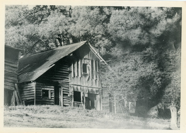 Mt Dandenong & District Historical Society Inc.
Photograph, Isaac Jeeves' Barn
Large barn built c1886 by Isaac Jeeves the younger on his property where the homestead 'Shiloah' stood. The barn was reputedly made from timbers split from only one messmate tree. Originally the home of Isaac Jeeves, brother of Ellis Jeeves, ‘Shiloah’ was enlarged to take guests in the early 1900s. It was situated close to a beautiful fern gully and Isaac and his family capitalised on this by setting out walking tracks through the ferns. They charged 1/- to walk through and this included afternoon tea in a garden setting. ‘Shiloah’ was a popular tourist attraction but the making of the Olinda Creek Road destroyed the fern gullies and, by the 1930s, it was all finished. John Lundy-Clarke grew up in the Kalorama/Mt Dandenong area and later in life (1972-74) began to write a comprehensive history of the area working from an original settlement map in an effort to cover all areas.Black and white photograph showing a large wooden structure surrounded by trees. Handwritten inscription on reverse by John Lundy-Clarke.Home of Isaac Jeeves the younger. Built about 1886 of timbers split from one messmate tree. Photo 1973isaac jeeves the younger, barn, kalorama, shiloah, messmate -
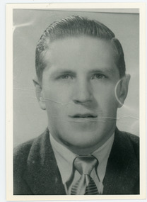 Mt Dandenong & District Historical Society Inc.
Photograph, Alan Price
John Lundy-Clarke grew up in the Kalorama/Mt Dandenong area and later in life (1972-74) began to write a comprehensive history of the district working from an original settlement map in an effort to cover all areas. Alan Price was the son of Edward John Price and Myra (nee Wilson) Price. He had a brother Edward Joseph 2nd (Teddie). Alan and Teddie were the grandsons of early settlers Edward Joseph and Annie (nee Ross) Price. Alan Price worked at his brother's depot in Ringwood, in charge of mechanical equipment. He rode to and from work on his motorbike. Alan was killed in a motorbike accident on his way home from work in 1971. Alan married Patricia Guerin in 1960. They had five daughters and one son. The family had a house on part of Lot 5 facing Mt Dandenong Road.Black and white close up of man in suit and tie. Reverse of photograph has handwritten description by John Lundy-Clarke. Alan Price 1969. Son of Edward John Price and Myra nee Wilson. alan price, patricia guerin, edward joseph (teddie) price, edward john price, myra price, myra wilson, edward joseph price, annie price, annie ross, kalorama, accident -
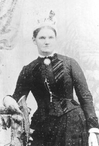 Linton and District Historical Society Inc
Photograph, Helen Christie, née Clarke
Copy of original photograph. Photograph shows an older woman with hair drawn back off face, wearing a hat and a long-sleeved, waisted outfit with front buttoned bodice, lace at throat and striped tie, large round brooch at throat, standing with left arm by her side, right arm bent hand resting on back of a chair."Helen Christie nee Clarke Mrs William Christie of Piggoreet Station".helen christie, helen clarke, mrs william christie, piggoreet station -
 Mt Dandenong & District Historical Society Inc.
Photograph, View From Doughty's Road 1974
John Lundy-Clarke grew up in the Kalorama/Mt Dandenong area and later in life (1972-74) began to write a comprehensive history of the area working from an original settlement map in an effort to cover all areas. This photograph shows approximately the same area as photograph number KAL0193 but is taken 60 years later. The trees have grown much taller and the buildings changed. On the site of the Paynter house 'Iona' there is now the 'Yosemite' (Villa Toscana) accommodation. The pavilion in the centre of the photo is the site of 'Kalorama', home of early pioneer Isaac Jeeves. The photograph is taken looking up towards The Gap (FiveWays).Black and white photograph showing a forested area with clear sites. Roofs of buildings can be clearly seen. Handwritten inscription on reverse by John Lundy-ClarkeView from near Doughty’s Rd looking north up valley to Kalorama Gap in Jan 1973. Tiny roof in centre is pavilion on site of “Kalorama”. Long roof to its left is Yosemite Motel on site of “Iona”.paynter, kalorama, iona, yosemite, villa toscana, five ways, the gap -
 Mt Dandenong & District Historical Society Inc.
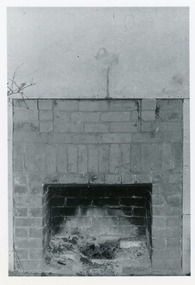
Photograph, Open Fire Place in Worker's Cottage, 1972
Photograph taken in 1972 showing an open fire place built of recycled brick in a worker's cottage. This photograph has a detailed inscription on the back handwritten by John Lundy-Clarke in 1974.Open fire place in workers cottage built of bricks from house built for John William Richardson 1897. Chimney built for Rowses by J. Lundy-Clarke May 1938. Picture taken 18-11-72 Richardsons house was pulled down by Rowse Bros. 1937-8. fireplace, richardson, rowse, john lundy-clarke -
 Bendigo Military Museum
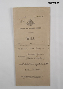
Legal record - WILL, Leonard John Clarke Coates, 3 Aug 1942
Leonard John Clarke Coates V27591 2nd Aust Field Squadron R.A.E. Mandatory for all soldiers to complete a Will. Part of the collection of the Coates Family. Refer 9654.4 for more family..1) Light brown envelope contains one foolscap piece of paper, also brown with last Will and Testament for Leonard John Clarke Coates. .2) Will handwritten on one side of a standard form with notes and instructions hand typed on other side, Paper folded 4 times and in envelope. Both form and front of the envelope have name, no, rank, and unit of soldier.1. Stamped “15 Aug 1942”, also filled in No, name, rank and Unit. .....”VX No, 134253 pencilled in and date “3/8/42” 2. On form same as above and dated “3/8/42” and back page in pen details of Willwill and testament, leonard john clarke coates, coates family 1 -
 Federation University Historical Collection
Photograph, Ian Wilson, Ceramic Tile Mosaic at the Robert Clarke Centre Community Resource Centre
Colour photograph of the ceramic tile mosaic at the Robert Clarke Centre Community Resource Centre, with the Diploma of Ceramics students who worked on it. ceramic mosaic, robert clarke centre, annalies egan, judith davis, janis yuille, margaret komishen -
 Ringwood and District Historical Society
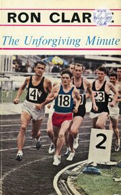
Book, The Unforgiving Minute (Ron Clarke) - Alan Trengove
Ron Clarke, among the greatest distance runners the world has seen, reveals the secrets behind his achievements to Alan Trengove -
![Book, Reid, Captain Mayne [Thomas Mayne Reid], The cliff-climbers; or, the lone home in the Himalayas, [n.d.] [before 1887]](/media/collectors/641920217f0478323d8a47a8/items/64a5f36ed4511475528da509/item-media/64bf6aa3d2135a5362458f4d/item-fit-380x285.jpg) Linton Mechanics Institute and Free Library Collection
Linton Mechanics Institute and Free Library CollectionBook, Reid, Captain Mayne [Thomas Mayne Reid], The cliff-climbers; or, the lone home in the Himalayas, [n.d.] [before 1887]
408 p.fictionjames dodds, original collection, fiction, thomas mayne reid -
 Mt Dandenong & District Historical Society Inc.
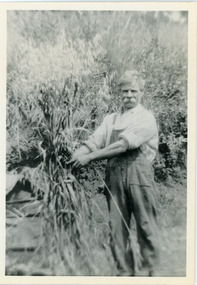
Photograph, Robert Logan
Robert Logan took up Lot 28 in the Village Settlement in 1896 and worked it until his death in 1936. His second son, Malcolm, took over the selection and continued to work it until he married and then it was subdivided. This photograph shows the oats that Robert Logan grew to feed his horse. John Lundy-Clarke grew up in the Kalorama/Mt Dandenong area and later in life (1972-74) began to write a comprehensive history of the area working from an original settlement map in an effort to cover all areas.Black and white photograph of a white haired man with a large white moustache man wearing overalls tying up a sheaf of hay. Handwritten description on reverse by John Lundy-Clarke.Robert Logan with hay grown on LOT 28 SECTION 1 of the Village Settlement. He was the original selector and his LOT was the last worked fully (by his son Malcolm) in SECTION 1. 1920. robert logan, logan, malcolm logan, kalorama, john lundy-clarke -
 Mt Dandenong & District Historical Society Inc.
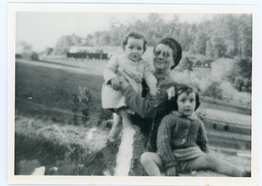
Photograph
The Wenborn family acquired Ferguson's Lot 19 of the Village Settlement where the original Mount Dandenong School was opened in a shed. WH Collom owned the land after Ferguson and then it passes to the Wenborns. This photograph, taken c1942, shows Ivy Wenborn with her daughters Mary and Joan. John Lundy-Clarke grew up in the Kalorama/Mt Dandenong area and later in life (1972-74) began to write a comprehensive history of the area working from an original settlement map in an effort to cover all areas.Black and white photograph of a woman nursing a young girl Another young girl is seated at her right.Behind is a view of trees and a house. Handwritten inscription on reverse by John Lundy-ClarkeWenborn Family. Looking across what is now Kalorama Park showing Norman Jeeves' house behind the hedge to the left of the child.wenborn, ivy wenborn, mary wenborn, joan wenborn, norman jeeves, kalorama park, jeeves -
Montmorency/Eltham RSL Sub Branch
Photograph - 7 pictures of LIndsay G Clarke VX43224 21st A-ITB, WW2 Photgraphs of LIndsay G Clarke and colleagues
1x Portrait photograph of Lindsay Clarke 1x Picture of Lindsay, Gordon and children 1x Picture of Lindsay Clarke and two Indian and Australian soldiers 1x Picture of Lindsay and 7 mates (one an officer) 1x Picture of Lindsay and 2 mates 1x Picture of Lindsay and ? brother or a cousin 1x Picture of Lindsay and ? friends with inscription ? from Bug One only picture from Bucks -
 Linton and District Historical Society Inc
Photograph, Gordon Clarke on his Birthday Pony
Gordon Clarke (1906-1996) was the grandson of David Clarke who bought Piggoreet West in 1855. His parents were John Clarke and Mary Jane Newcomen. Gordon Clarke purchased land between Piggoreet and Linton, known as the 'Bird Paddock', and began to intensively plant indigenous species, with a view to providing habitat for native birds. This land was afterwards expanded and is now known as the Clarkesdale Bird Sanctuary. In the 1970s, Gordon donated the sanctuary to the Bird Observers Club of Australia.Black and white copy of original photograph a boy sitting bareback on a horse with no bridle.horses, gordon clarke -
 Charlton Golden Grains Museum Inc
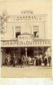
Photograph, Clarke Bros Photographers, W. Wylie shop, c.1890
W. Wylie's store, west end of High St, Charlton. built by Peter Johnson c. 1872, managed by Mr. Gatwood c.1880s, then bought by William Wylie. Group of people standing outside on footpath, young man on a bicycle, 2 children and a man in upstairs windowMounted unframed photograph. W. Wylie's store, west end of High St, Charlton. Group of nine people standing outside on footpath, includes three women, a young man on a bicycle being held by another young man, 2 children and a man in upstairs windowClarke Bros Photographers Windsorw. wylie, general importer, draper & outfitter, johnson's bridge store, high street, charlton -
 Mt Dandenong & District Historical Society Inc.
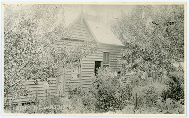
Photograph, Home and Shop of Edward Joseph Price
John Lundy-Clarke grew up in the Kalorama/Mt Dandenong area and later in life (1972-74) began to write a comprehensive history of the district working from an original settlement map in an effort to cover all areas. Edward Joseph Price was the first settler to take up a lot (Lot 1, Section 1) in the Village Settlement. He built a slab hut and brought up his family in 1896. This photograph shows a newer home built in 1908. It had a section used as a shop and also had a large room built that was to be used for public gatherings. Health department regulations led to this being impossible. The house faced Ridge Road.Black and white close up photograph showing a building made from wooden boards with trees in the front. Reverse of photograph has handwritten description by John Lundy-Clarke.On Front STORE MT DANDENONG On Reverse Home and Shop of Edward Joseph Price LOT 1 SECT 1 erected in 1908 on site of earlier dwelling from which goods had been sold without a special room for shop. In picture the room on the extreme left was bedroom for boys Charlie and Ted (Edward John). Under the gable was a large room planned for public use but never used owing to Health Department Regulations. The narrow door (open) and window were the shop which was the district’s first newsagency. Window behind leaves at right was the kitchen. 1908-1912. Gabled portion is now part of home “Mirra Laken” 1975edward joseph price, store, shop -
 Mt Dandenong & District Historical Society Inc.
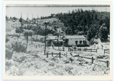
Photograph, View Up Valley At Kalorama
John Lundy-Clarke grew up in the Kalorama/Mt Dandenong area and later in life (1972-74) began to write a comprehensive history of the area working from an original settlement map in an effort to cover all areas. The building in the centre of the photograph is 'Kia-Ora' guest house. Situated on Barber’s Road, ‘Kia-Ora’ was built in 1912 by George Barber. It was later leased by a Mrs Pemberthy. “Kia-Ora’ was one of four places connected when the telephone was brought into the district in 1912. The other places were ‘Mountjoy’, ‘Cherry Farm’ and ‘Callum House’. ‘Kia-Ora’ was burnt down in 1924. Black and White copy of section of a Rose Series postcard. Shows view up the valley at Kalorama with a decorative building centre middle of photograph. Handwritten description by John Lundy-Clarke on reverse.View up valley at Kalorama from near junction of Barbers and Doughty’s Rds. “Kia Ora” guest house in centre. Paynter’s “Iona” top left with “Kalorama” to its right. About 1912. Rose Series copied by JLC 1973.kalorama, kalorama valley, john lundy-clarke, barbers road, george barber, kia-ora, guest house, iona -
 St Kilda Historical Society
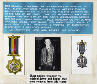
Photograph, Remembrance of Bro H M T P Clarke, foundation member of the Loyal Elsternwick Lodge M U I O O F
Clarke died 17 Aug 1962 aged 87 -
 Stawell Historical Society Inc
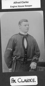
Photograph, Stawell Fire Brigade's Fireman A Clarke 1885 -- Studio Portrait
Portrait. Fm. A Clarke. Stawell Fire Brigade 1885stawell -
Tatura Irrigation & Wartime Camps Museum
Book - Family Tree, Clarke Rees Family
Folder containing photographs and information regarding the Clarke Rees family. Grey archives folder containing family tree information.young, rees, clarke, pullbrook -
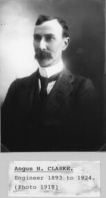 Stawell Historical Society Inc
Photograph, Mr Angus H Clarke -- STAWELL SHIRE COUNCILLORS 1918 -- Studio Portrait
Portrait - Angus H. Clarke - STAWELL SHIRE COUNCILLORS 1918stawell government -
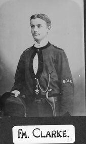 Stawell Historical Society Inc
Photograph, Stawell Fire Brigade's Fireman Clarke 1885 & 1893 -- Studio Portrait
Portrait. Fm. Clarke. Stawell Fire Brigade 1885 and 1893stawell