Showing 379 items
matching main road montmorency
-
 Eltham District Historical Society Inc
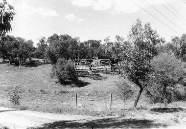
Photograph - Black and White Print, Unidentified road, Eltham district, possibly Montmorency, c. Sep. 1966
Black and white photographic printOriginally located in a Filmpro King Size Prints processing envelope $3.01 Shire of Eltham 9/9/66 and noted as Calrossie Ave area and crossed out Eltham-Yarra Glen Road, Bridge Street to Elsa Court existing conditions mid 1967infrastructure, roads, unidentified -
 Eltham District Historical Society Inc
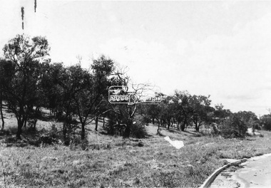
Photograph - Black and White Print, Unidentified road, Eltham district, possibly Montmorency, c. Sep. 1966
Black and white photographic printOriginally located in a Filmpro King Size Prints processing envelope $3.01 Shire of Eltham 9/9/66 and noted as Calrossie Ave area and crossed out Eltham-Yarra Glen Road, Bridge Street to Elsa Court existing conditions mid 1967infrastructure, roads, unidentified -
 Eltham District Historical Society Inc
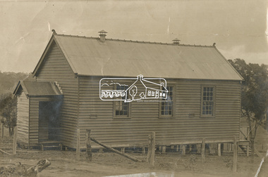
Photograph - Sepia Print, Unidentified hall; possibly the Montmorency Presbyterian Church Hall, Rattray Road, Greensborough, c.1918
From Eltham Montmorency Uniting Church, History http://www.elthammontmorencyuca.org/history/ In 1914 a small group of Presbyterians living on 'The Montmorency Estate', which had been established when the railway was extended to Eltham several years before, began meeting for worship in the Rattray Rd home of Robert Sharpe. Two years later a small weatherboard church, administered from Scots Church, Heidelberg, was built on land donated by Mr. Sharpe. In 1931 this building was moved to the corner of Rattray Road and Mountain View Roads. In the next few years local elders were elected and the congregation adopted the name St. Andrew’s Presbyterian Church, Montmorency.montmorency, montmorency presbyterian church hall, rattray road -
 Eltham District Historical Society Inc
Slide - Photograph, Eltham Shire Council, Plan of Subdivision, Part of Crown Portion 3, Parish of Nillumbik, County of Bourke, 1969
35mm colour positive transparency blue Agfacolour Service plastic mountC5C, Delbridge, 4 lots, Rattray Road, 4 August 1969infrastructure, map, montmorency, planning, rattray road, subdivison lots, reichelt avenue -
 Eltham District Historical Society Inc
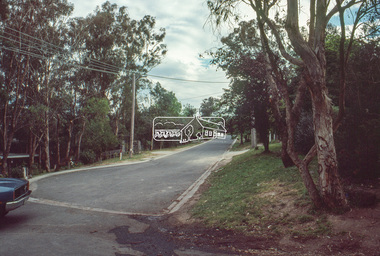
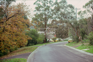
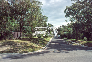
Slide - Photograph, Eltham Shire Council, Unidentified street, possibly Montmorency or Eltham North, c.Oct. 1980
35mm colour positive transparency (1 of 24) Mount - Kodak Kodachrome Cardeltham north, houses, infrastructure, roads, montmorency, unidentified -
 Eltham District Historical Society Inc
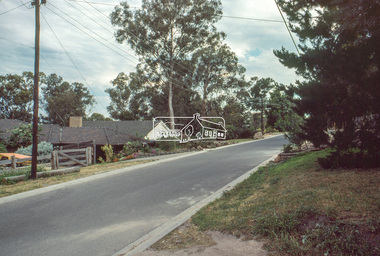
Slide - Photograph, Eltham Shire Council, Unidentified street, possibly Montmorency or Eltham North, c.Oct. 1980
35mm colour positive transparency (1 of 24) Mount - Kodak Kodachrome Cardeltham north, houses, infrastructure, roads, montmorency, unidentified -
 Eltham District Historical Society Inc
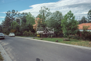
Slide - Photograph, Eltham Shire Council, Unidentified street, possibly Montmorency or Eltham North, c.Oct. 1980
35mm colour positive transparency (1 of 24) Mount - Kodak Kodachrome Cardeltham north, houses, infrastructure, roads, montmorency, unidentified -
 Eltham District Historical Society Inc
Slide - Photograph, Eltham Shire Council, Unidentified street, possibly Montmorency or Eltham North, c.Oct. 1980
35mm colour positive transparency (1 of 24) Mount - Kodak Kodachrome Cardeltham north, houses, infrastructure, roads, montmorency, unidentified -
 Eltham District Historical Society Inc
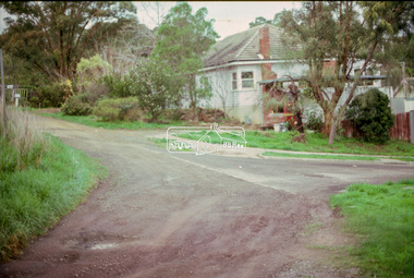
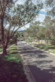
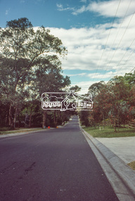
Slide - Photograph, Unidentified street, possibly Montmorency, c.Jun. 1986
35mm colour positive transparency (1 of 7) Mount - Kodak Kodachrome CardProcess Date JUN 86Mroads, infrastructure, montmorency, unidentified -
 Eltham District Historical Society Inc
Slide - Photograph, Unidentified street, possibly Montmorency, c.Jun. 1986
35mm colour positive transparency (1 of 7) Mount - Kodak Kodachrome CardProcess Date JUN 86Mroads, infrastructure, montmorency, unidentified -
 Eltham District Historical Society Inc
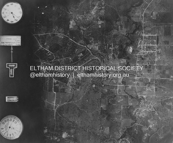
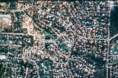
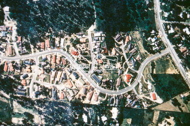
Photograph - Aerial Photograph, Landata, Eltham and Montmorency, Nov. 1931
Centred over present-day Belmont Reserve, Montmorency Historic Aerial Imagery Source: Landata.vic.gov.au Aerial Photo Details: Project No :1931 Project : MALDON PRISON Run : 19 Frame : 3130 Date : 11/1931 Film Type : B/W Camera : F8 Flying Height : 11000 Scale : 18860 Film Number : 60 GDA2020 : 37°43'13"S, 145°07'54"E MGA2020 : 335330, 5823576 (55) Melways : 21 F6 (ed. 42)aerial photo, eltham, neil webster collection, belmont reserve, montmorency, rattray road -
 Eltham District Historical Society Inc
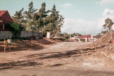
Slide, Reconstruction of Grand Boulevard viewed from Panorama Avenue, Montmorency, 18 August 1970, 1970
The Eltham Apex Club conducted a Community Service Project (1965-1968) to raise funds for a new Ambulance Station to service the community. A site bounded by the intersection of Main Road, Grand Boulevard and Looker Road at Montmorency was purchased in 1969. In 1970, Eltham Shire Council undertook roadworks to construct Apex Way in preparation for the new station as well as duplicate Main Road, Lower Plenty, east of Grand Boulevard including the new Lower Plenty Bridge, which had been opened in November 1966, bordering with the City of Heidelberg.35 mm colour positive transparency Mount - Agfacolor Service (Blue)1970-08-18, apex-diamond valley ambulance station, eltham ambulance station, eltham apex club, grand boulevard, montmorency -
 Eltham District Historical Society Inc
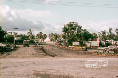
Slide, Construction of Apex Way between Looker Road and Grand Boulevard, Montmorency, 18 August 1970, 1970
The Eltham Apex Club conducted a Community Service Project (1965-1968) to raise funds for a new Ambulance Station to service the community. A site bounded by the intersection of Main Road, Grand Boulevard and Looker Road at Montmorency was purchased in 1969. In 1970, Eltham Shire Council undertook roadworks to construct Apex Way in preparation for the new station as well as duplicate Main Road, Lower Plenty, east of Grand Boulevard including the new Lower Plenty Bridge, which had been opened in November 1966, bordering with the City of Heidelberg.35 mm colour positive transparency Mount - Agfacolor Service (Blue)1970-08-18, apex-diamond valley ambulance station, eltham ambulance station, eltham apex club, grand boulevard, looker road, montmorency -
 Eltham District Historical Society Inc
Photograph, Liz Pidgeon, Eltham Ambulance Station, Metropolitan Ambulance Service, Apex Way, Montmorency, just prior to demolition, 7 November 2017, 7 Nov 2017
The Eltham Apex Club conducted a Community Service Project (1965-1968) to raise funds for a new Ambulance Station to service the community. A site bounded by the intersection of Main Road, Grand Boulevard and Looker Road at Montmorency was purchased in 1969. In 1970, Eltham Shire Council undertook roadworks to construct Apex Way in preparation for the new station as well as duplicate Main Road, Lower Plenty, east of Grand Boulevard including the new Lower Plenty Bridge, which had been opened in November 1966, bordering with the City of Heidelberg. The Eltham Ambulance Station was opened 4 May 1975 by the Hon. Roy M. Vale, M.L.A. It was demolished in November 2017 to make way for a new larger station which also houses a MICA unit, opened 29 August 2018 by the Hon. Jill Hennessey, Minister for State Ambulance Services.20 born digital imagesambulance station, apex way, eltham ambulance station, eltham apex club, montmorency -
 Eltham District Historical Society Inc
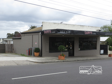
Photograph, Liz Pidgeon, Taffy's on Looker, Milk Bar, Looker Road, Montmorency, 7 November 2017, 7 Nov 2017
2 born digital imageslooker road, milk bar, montmorency, taffy's on looker -
 Eltham District Historical Society Inc
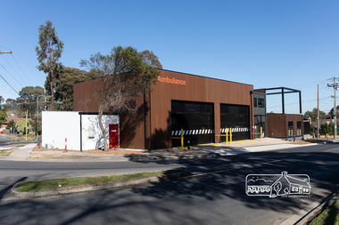
Photograph, Peter Pidgeon, Official opening of the new Eltham Ambulance Branch, Apex Way, Montmorency, 29 August 2018, 29 Aug 2018
Dignitaries included Ambulance Victoria CEO Tony Walker, Vicki Ward MP for Eltham and Jill Hennessey State Ambulance Services Minister The Eltham Apex Club conducted a Community Service Project (1965-1968) to raise funds for a new Ambulance Station to service the community. A site bounded by the intersection of Main Road, Grand Boulevard and Looker Road at Montmorency was purchased in 1969. In 1970, Eltham Shire Council undertook roadworks to construct Apex Way in preparation for the new station as well as duplicate Main Road, Lower Plenty, east of Grand Boulevard including the new Lower Plenty Bridge, which had been opened in November 1966, bordering with the City of Heidelberg. Diamond Valley Leader, September 5, 2018, p4. MONTMORENCY $1.6mil station unveiled A REVAMPED Montmorency ambulance station has been unveiled. State Ambulance Services Minister Jill Hennessy and Eltham State Labor MP Vicki Ward revealed the $1.6 million complex at the corner of Grand Boulevard and Apex Way in Montmorency. It replaces the 50-year-old station and now includes four ambulance bays, four rest and recline rooms, a large training room and offstreet parking for staff. “The community campaigned long and hard for this new ambulance station and I’m delighted to have stood with them all the way,” Ms Ward said. The latest quarterly performance data showed 90.4 per cent of ambulances in Banyule arrived within 15 minutes of Code 1 emergencies — up from 89.2 per cent three months earlier. Ms Hennessy said paramedics had worked in “cramped” facilities. “We’ve fixed that,” she said.55 born digital imagesambulance victoria ceo, apex way, apex-diamond valley ambulance station, eltham ambulance station, eltham apex club, jill hennessey, montmorency, mp for eltham, state ambulance services minister, tony walker, vicki ward -
 Eltham District Historical Society Inc
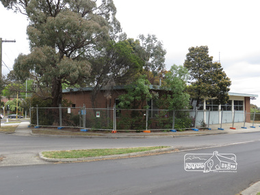
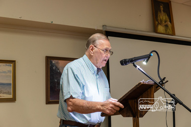
Photograph, Peter Pidgeon, Bill McKenna, former President of Montmorency-Eltham RSL; Eltham Community Town Hall Meeting, Eltham Senior Citizen's Centre, 13 October 2018, 13 Oct 2018
Community meeting held at the Eltham Senior Citizen's Centre to discuss Nillumbik Shire Council's advertised proposal to sell the former Shire Office site at 895 Main Road and the Eltham War Memorial complex of buildings at 903-907 Main Road; 13 October 2018Born digital image895 main road, 903-907 main road, community meeting, eltham pre-school, eltham shire office, eltham war memorial, eltham war memorial hall, infant welfare centre, nillumbik shire council, senior citizen's centre -
 Eltham District Historical Society Inc
Folder, Pioneers & Painters; Shire of Eltham Historical Society research notes, background information, etc, 1969-1986, 1969-1986
Material pertaining to the production of a history of the Shire of Eltham, "Pioneers & Painters: One Hundred Years of Eltham and its Shire" in recognition of the shire's centenary in 1971 Item Title Caption 04768-1 Newspaper clipping - The Eltham of 1905; Gellibrand our first white visitor? Diamond Valley News, 24 June 1969, p5 04768-2 Newspaper clipping - The Eltham of 1905; Gellibrand our first white visitor? Heidelberger, 25 June 1969 04768-3 Notes on Eltham District Road Board Members 1866-1871 04768-4 Notes on Eltham District Road Board Members 1866-1871 04768-5 Map showing Gellibrand's likely route through district 12-13 February 1836 and Hoddles's route of Febrary 1838 04768-6 Notes by Shire Secretary, M.B. Watson regarding meeting with Reverend Longfield regarding history of St Margaret's Church 04768-7 Alan Marshall's notes from discussion with Mr. F. Barrett regarding SEPP images 611, 635 and 636 SEPP_0611 SEPP_0635 SEPP_0636 04768-8 Transcripts of letter from local residents to Charles Joseph Latrobe requesting a bridge over the Plenty River dated 10 April 1849 and his reply dated 5 May 1849; from Latrobe Library Archives - Land Branch Records 04768-9 Notes on history of Eltham Shire, Centenary events and publication of Pioneers & Painters for release in conjunction of opening of new Library 04768-10 Newspaper clipping - Glossy record of shire's romantic past and the people who made it by Fab Calafuri, Diamond Valley News, Tuesday, December 16, 1986, p18 SEPP_0755-3 Letter: Acknowledgement from Colin J. Bock, Eltham Shire Secretary to A.R. Thomas of Bendigo for copy of 1913 photograph of Shire of Eltham Councilors, 21 May 1973 A.R. Thomas' father Mr. A.G. Thomas, C.E., was the Shire Secretary at the time in 1913. Cross Ref: SEPP_0755 The idea to develop a book on the history of the Shire of Eltham to be edited by noted author, Alan Marshall in celebration of the shire's centenary was initiated in 1969. The Shire of Eltham Historical Society undertook significant research in conjunction with Alan Marshall locating material at various institutions and other societies; interviewing longer term residents and a public campaign through the local press to acquire photographic material for duplication and use in the book. The public campaign received generous response and the material collected became the genesis for the Shire of Eltham Pioneers Photograph collection now held in partnership between Eltham District Historical Society and Yarra Plenty Regional Library (Eltham Library).Paper documents of various sizes and newspaper clippingsa.g. thomas, a.r. thomas, alan marshall, bridge road, charles joseph latrobe, council members, d.w. lachlan, eltham district road board, eltham shire council, ernie orford, f. barrett, francis rogerson, g. bransprone, james donaldson, james johnston, john bell, john thomson, joseph tice gellibrand, lower plenty bridge, m.b. watson, main road, map, patrick turnbull, peter morris, pioneers and painters, post office, rev. longfield, sepp, shire of eltham pioneers photograph collection, shire secretary, st margaret's church, thomas armstrong, thomas bell, thomas sweeney, william bell (1796-1870), centenary celebrations, christmas hills, clifton pugh, david newbury, dudley street, eltham, gareth jones roberts, hurstbridge, john perceval, joy peck, kangaroo ground, kinglake, lower plenty, luther haley general store, montmorency, neil douglas, panton hill, peter glass, research (vic.), sheila ferguson, shire of eltham, st andrews, yarra glen -
 Eltham District Historical Society Inc
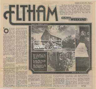
Newsclipping, Eltham, Report by Andrew Mckay, Pictures by Noel Butcher, The Herald, 26 July 1975, pp 21-22, 26 Jul 1975
Digital file only - Digitised by EDHS from a scrapbook on loan from Beryl Bradbury (nee Stokes), daughter of Frank Stokes.alistair knox, alma road, arthur munday, beryl bradbury (nee stokes) collection, cameron jackson, carina hack, charlie macgillicuddy, charlie stevenson, circus, clifton pugh, david stephens, dorian le gallienne, eltham, eltham college, eltham hotel, eltham living and learning centre, eltham town square, eltham village, george paul, graham bell, great hall, green wedge, harold holt, jazz, jim chinaman's road, justus jorgensen, kangaroo ground, lower plenty, marcus skipper, matcham skipper, montmorency, montsalvat, mud brick construction, mudbrick, myra skipper, professor dick downing, professor macmahon ball, professor richard downing, research (vic.), roger bell, shire of eltham, shire president, shopping centre, swiper's gully, tim burstall, white cloud cottage -
 Eltham District Historical Society Inc
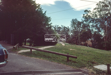
Photograph, W 27, Mitchell Avenue (Reserve next to Montmorency South Primary), 1966c
Grand Boulevard on right. Looking at what is now Panorama Heights preschoolBlack and white photographic printOriginally located in a Filmpro King Size Prints processing envelope $3.01 Shire of Eltham 9/9/66 and noted as Calrossie Ave area and crossed out Eltham-Yarra Glen Road, Bridge Street to Elsa Court existing conditions mid 1967grand boulevard, mitchell avenue, montmorency, panorama heights pre-school -
 Eltham District Historical Society Inc
Photograph, Plenty River at end of Palara Court, Montmorency, c.September 1966, 1966c
Black and white photographic printOriginally located in a Filmpro King Size Prints processing envelope $3.01 Shire of Eltham 9/9/66 and noted as Calrossie Ave area and crossed out Eltham-Yarra Glen Road, Bridge Street to Elsa Court existing conditions mid 1967montmorency, palara court, plenty river -
 Eltham District Historical Society Inc
Slide - Photograph, Wooded Way, Montmorency, c.Jun. 1986
35mm colour positive transparency (1 of 7) Mount - Kodak Kodachrome CardProcess Date JUN 86Mroads, infrastructure, wooded way, montmorency -
 Eltham District Historical Society Inc
Slide - Photograph, Grand Boulevard, Montmorency, c.Aug. 1978
35mm colour positive transparency Mount - Grey and Whitegrand boulevard, infrastructure, montmorency, roads, olympic avenue, roundabout -
 Eltham District Historical Society Inc
Slide, Price Avene, Montmorency, Oct. 1980
35mm colour positive transparency (1 of 24) Mount - Kodak Kodachrome Cardinfrastructure, lilicur road, montmorency, price avenue, roads -
 Eltham District Historical Society Inc
Slide, Price Avene, Montmorency, Oct. 1980
35mm colour positive transparency (1 of 24) Mount - Kodak Kodachrome Cardinfrastructure, lilicur road, montmorency, price avenue, roads -
 Eltham District Historical Society Inc
Photograph, Baldwin Avenue, Montmorency, Oct. 1980
35mm colour positive transparency (1 of 24) Mount - Kodak Kodachrome Cardbaldwin avenue, infrastructure, montmorency, roads -
 Eltham District Historical Society Inc
Slide - Photograph, Aerial Photo (c.1987): Main Road, Eltham from Pitt Street to Elsa Court, c.Aug. 1990
Part of a presentation, "Roads and Byways of the Shire of Eltham", by Russell Yeoman to the 12 September 1990 Society meeting. Slides shown included copies of old photos and recent images ranging from the suburban streets of Eltham and Montmorency to the mountain roads of Kinglake. In the byways category are views of some iof the Shire's bicycle paths including then recently completed sections of the Main Yarra Trail at Lower Plenty.35mm colour positive transparency (1 of 37) Mount - Agfachrome Agfa CS System black 8 dotsinfrastructure, roads, aerial photographs, alistair knox park, bridge street, central park, diamond street, elsa court, eltham, eltham common, eltham railway station, eltham town park, main road, pitt street -
 Eltham District Historical Society Inc
Slide - Photograph, Aerial Photo (c.1987): Woodridge Estate, Eltham, c.Aug. 1990
Part of a presentation, "Roads and Byways of the Shire of Eltham", by Russell Yeoman to the 12 September 1990 Society meeting. Slides shown included copies of old photos and recent images ranging from the suburban streets of Eltham and Montmorency to the mountain roads of Kinglake. In the byways category are views of some iof the Shire's bicycle paths including then recently completed sections of the Main Yarra Trail at Lower Plenty.35mm colour positive transparency (1 of 37) Mount - Agfachrome Agfa CS System black 8 dotsinfrastructure, roads, aerial photographs, eltham, housing estate, woodridge estate -
 Eltham District Historical Society Inc
Slide - Photograph, Aerial Photo (c.1987): Main Road and Leanne Drive, Eltham, c.Aug. 1990
Part of a presentation, "Roads and Byways of the Shire of Eltham", by Russell Yeoman to the 12 September 1990 Society meeting. Slides shown included copies of old photos and recent images ranging from the suburban streets of Eltham and Montmorency to the mountain roads of Kinglake. In the byways category are views of some iof the Shire's bicycle paths including then recently completed sections of the Main Yarra Trail at Lower Plenty.35mm colour positive transparency (1 of 37) Mount - Agfachrome Agfa CS System black 8 dotsinfrastructure, roads, aerial photographs, eltham, leanne drive, main road -
 Eltham District Historical Society Inc
Slide - Photograph, Aerial Photo (c.1987): Main Road, Fitzsimons Lane, Lower Plenty, c.Aug. 1990
Part of a presentation, "Roads and Byways of the Shire of Eltham", by Russell Yeoman to the 12 September 1990 Society meeting. Slides shown included copies of old photos and recent images ranging from the suburban streets of Eltham and Montmorency to the mountain roads of Kinglake. In the byways category are views of some iof the Shire's bicycle paths including then recently completed sections of the Main Yarra Trail at Lower Plenty.35mm colour positive transparency (1 of 37) Mount - Agfachrome Agfa CS System black 8 dotsinfrastructure, roads, aerial photographs, roundabout, bolton steet, bolton steet shops, eltham, fitzsimons lane, lower plenty, main road