Showing 2322 items
matching melbourne street plan
-
 Eltham District Historical Society Inc
Slide - Photograph, Eltham Shire Council, Proposed extension of Railway Road, Briar Hill, 1969
35mm colour positive transparency blue Agfacolour Service plastic mountA4, Railway Road intersection, 4 August 1969infrastructure, map, planning, subdivison lots, railway road, carter street bridge, para road, para road bridge, briar hill -
 Eltham District Historical Society Inc
Slide - Photograph, Eltham Shire Council, Plan of Subdivision, Part of Crown Allotments 5 & 6, Section 10, Parish of Nillumbik, County of Evelyn (Foster Road, Eltham East), 1969
35mm colour positive transparency blue Agfacolour Service plastic mountC5(a) DU (Vic) D/L Foster Road, Eltham East, 4 August 1969infrastructure, map, planning, subdivison lots, abersham court, ancona close, eltham east, floriston grove, foster road, frank street, gladwyn court -
 Eltham District Historical Society Inc
Document, Samantha Westbrooke Pty Ltd et al, 2 Bell Street, Eltham: Cultural Heritage Significance Assessment & Heritage Guidelines for Future Use & Development, 2012
Prepared for Nillumbik Shire Council by Samantha Westbrooke Pty Ltd in association with Peter Mills PhD, Architectural Historian and Roark Muhlen-Schilte, Archaeologist. Covers history of early market gardening in Eltham with the commencement of European settlement in the late 1830s. The site for the village of Eltham was surveyed in 1851 and the Township Plan shows that the property is made up of Lots 7 and 8 which were sold at auction in June 1852 to M. O'Shea. The history of the Bell Street property is closely tied to the West family from the 1860s to 1930s; the earliest rate books for Eltham show William West farming in El;tham in 1864. In the aerly 1930s ownership of the creek side was transferred from the west family to the Fabbro family who shortly afterwards were impaced by the 1934 Diamond Creek flooding. Guido Fabbro relocated the original West home further up the hill and built a new Italianate style modern home in situ. The Fabbro family farmed the property. In 1993/4 Eltham Council acquired the creek-side market garden blocks to the south of 2 Bell Street which was recconceived in 1998 as the Barak Bushland Reserve. The Fabbro house was demolished shortly after and the lots were sold to a developer in 1994. The large steel shed now present on the 2 Bell Street property dates from soon after this sale.26 A4 pages color printcultural heritage significance assessment, peter mills, samantha westbrooke pty ltd, shire of nillumbik, 2 bell street, eltham, market gardening, west family, fabbro family, land use, barak bushland reserve, heritage assessment -
 Eltham District Historical Society Inc
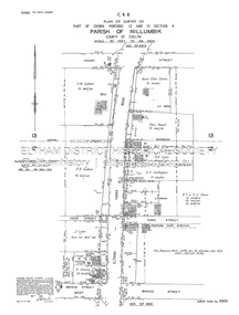
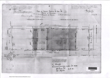
Document - Survey Plan, Country Roads Board, SP 6800, Eltham-Yarra Glen Road; Bridge St to Henry St, 1958
1958 C.R.B. Plan of Survey of Part of Crown Portions 12 and 13 Section 4 Parish of Nillumbik, County of Evelyn Eltham-Yarra Glen Road., Shire of Eltham Shows Surveyor field notes, property ownership and building type and construction.1958, a.m. gahan, a.s & s.j. davis, annie ellen davies, bridge street, country roads board, d.a. lyon, dave lyon, eltham, flora towell, g.e. gallagher, henry street, j. lyon, k. greene, main road, p.a. gahan, survey plan, w.l. chynoweth pty ltd, york street, neil webster collection -
 Eltham District Historical Society Inc
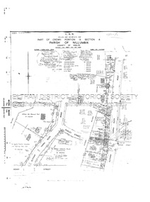
Document - Survey Plan, Country Roads Board, SP 6801, Eltham-Yarra Glen Road; Brougham St to Bridge St, 1958
1958 C.R.B. Plan of Survey of Part of Crown Portion 12 Section 4 Parish of Nillumbik, County of Evelyn Eltham-Yarra Glen Road, Shire of Eltham Shows Surveyor field notes, property ownership and building type and construction.a.j. collis, a.s. & c.g.h. fitzpatrick, board of land & works, bridge street, brougham steet, commonwealth bank of australia, country roads board, eltham, eltham rsl sub-branch, f.h. collis, f.m. smith, f.n. & e.j. burgoyne, franklin street, h.c. & r.e. burgoyne, j. jorgenson, j.f. & j.e. morris, j.n. & h.c. burgoyne, j.s. blow, john street, main road, p.e. smith, pitt street, r.j. dripps, s.j. taylor, survey plan, trustees of the eltham methodist church, 1958, eltham-yarra glen road, neil webster collection -
 Eltham District Historical Society Inc
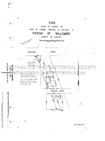
Document - Survey Plan, Country Roads Board, SP 6802, Eltham-Yarra Glen Road; Brougham St to Dalton St, 1958
1958 C.R.B. Plan of Survey of Part of Crown Portion 12 Section 4 Parish of Nillumbik, County of Evelyn Eltham-Yarra Glen Road, Shire of Eltham Shows Surveyor field notes, property ownership and building type and construction.1958, eltham-yarra glen road, a.f. munday, bible street, brougham steet, country roads board, dalton street, eltham, j.p. & e.a. sanders, j.w. & e. m. graham, l.c. skipper, l.m. jarrold, main road, napoleon street, survey plan, neil webster collection, franco and co -
 Eltham District Historical Society Inc
Document - Survey Plan, Country Roads Board, SP 6313, Eltham-Yarra Glen Road; Luck St to Henry St, 1956
1956 C.R.B. Plan of Survey of Part of Crown Portion 13 Section 4 Parish of Nillumbik, County of Evelyn Eltham-Yarra Glen Road, Shire of Eltham Shows Surveyor field notes, property ownership and building type and construction.eltham-yarra glen road, country roads board, eltham, main road, survey plan, 1956, a.l. lyon, a.w. brinkkotter, arthur street, c.r. burkett, dudley street, e.n. staff, eltham war memorial trust, henry street, luck street, pryor street, the board of land & works, the equity trustees executors and agency coy ltd, the roman catholic trusts corporation, victorian railways commision, neil webster collection -
 Eltham District Historical Society Inc
Document - Survey Plan, Country Roads Board, SP 6559-6560, Eltham-Yarra Glen Road; Elsa Ct to Luck St, 1957
1957 C.R.B. Plan of Survey of Part of Crown Portion 13 Section 4 and Crown Allotment 1 Section 1 Parish of Nillumbik, County of Evelyn Eltham-Yarra Glen Road, Shire of Eltham Shows Surveyor field notes, property ownership and building type and construction.eltham-yarra glen road, country roads board, eltham, main road, survey plan, 1957, a.m. & a.a. iowerson, a.mcg. hepburn, cecil street, coffee lounge, diamond street, e.g. murrell, elsa court, h.b. woodhead, j.c. & s.i. harding, la ronde, luck street, r.m. & v.m. white, r.n. mowatt, the board of land & works, w.g. hains, neil webster collection -
 Glen Eira Historical Society
Article - Third Church of Christ, Scientist, Elsternwick
5 Articles about the building which used to be Third Church of Christ, Scientist Elsternwick. The first one is an article from leader newspaper dated 27 July 2010 discussing the plan to convert former Christian Science Church and latterly Buddhist organisation into apartments. The second article is from Leader Newspaper dated 10 August 2010, commenting on disruptions that might occur with redevelopment. Third article is from Caulfield Leader, 07/09/2010. The article is on continuing discussion on proposed plans for the building which previously was a historic church. Also mentioned, residence’s concern and complains about the plan. The fourth article from Caulfield/ Port Phillip Leader, 24/05/2011, mainly talks about similar development at 221 -229 Glen Huntly Road. It also touches the subject of 233 – 147 Glen Huntly Road and 12 – 14 Ripon Grove as well. It is written that VCAT allowed the development of 10 storey building after overturning council decision. The fifth article is from Melbourne Bayside Weekly, 28/03/2012. It talks about the history of The Church of Christ, Scientist and about the old church building that still stands.ripon grove, gordon street, contour consultant, glen eira, historic sites, buddhist clubs and associations, elsternwick, glen huntly road, church, wait peter, wright kristen, kate ms, sinclair street, soka gakkaii, local government, local officials and employees, mc combie street, david street, ward camden, holden lars., connellan rose, connellan cathlea, connellan marilyn, third church of christ scientist elsternwick, heritage victoria, victorian civil and administration tribunal, eddy mary baker, clifton andrew, sammon jason, di paolo lucy, robinson andrew, ling jenny, church of christ scientist -
Glen Eira Historical Society
Plan - Uniting Church Archives, Orrong Road, 78-66, Elsternwick
Six documents including plan and correspondence between Elsternwick Methodist Church, Public Health Department and Beddoe Pty Ltd concerning the application to make alterations and additions including the erecting of a brick kindergarten from 30/07/1937 to 03/03/1939.elsternwick methodist church, orrong road, beddoe pty ltd., halls, kindergarten, robinson c.h., briggs james r., beddoe f.g., charlesworth a.c., methodist church trust, town clerks, hoddle street -
 Glen Eira Historical Society
Document - Japanese School of Melbourne
Six documents about the Japanese School: 1/The Japanese School of Melbourne Planning Brief document draft February 1984 to the City of Caulfield. Brief includes background of school, current educational standards of school and structure, future plans, including forecast of future student numbers, request to use prefabricated rooms. Also plans for new building and room alterations. Includes appendice which has current and projection graph of students attending. Period covered: January 1968-February 1984 (17 pages). 2/Fourteen page school prospectus, which includes history and location, term dates, school hours, curriculum subjects, teachers qualifications, health department approval and enrolment list. Also includes Division of School Duties, school educational aims and guidance priorities. Period covered: 07/09/1968-13/05/1986. 3/An 11/11/1988 Melbourne Development and Prospectus for the Japanese School of Melbourne, includes purpose of school, development options, planning brief, construction time, and development program. Includes seven plans and maps of school location and bus routes (14 pages). Prepared for the City of Caulfield on its request. 4/List of representatives of the Japanese School of Melbourne that met with City of Caulfield councilors on 23/11/1988. 5/Black and white photo of 'Ian Rob with Japanese students September 1991', six students included. 6/Colour photograph of 'Mayor Ed Biggs with Japanese students February 1992', thirteen adults and young people included.japanese school of melbourne limited, japanese school, caulfield, holy cross catholic, holy cross school, ellington school, keeron street, mockridge stahle and mitchell architects, architects, secondary schools, primary schools, playgrounds, hawthorn road, caulfield south, yaji hidero, japanese community, yazaki yasuo, morita hiroshi, teachers, bloink des, stokes tony, building surveyors, japanese supplementary school of melbourne, school committees, libraries, school houses, brick, bloink clarke harding consulting architects group, anthony stokes and assoc. building surveyors and town planners, rob ian, biggs ed mayor -
Glen Eira Historical Society
Map - Kilvington Baptist Girls Grammar School
One hard copy and one photocopy of Kilvington Baptist Girls Grammar School Planning brief dated October 1982. The brief details the current needs of the school and has been written to spell out a forward plan for development in the foreseeable future. It includes data on the current forecast enrolments at primary and secondary levels as well as the current and future use and development of the buildings and their use. Author of the brief is unknown.kilvington baptist girls grammar school, schools, ormond, lillimur road, walsh street, ormond girls school, kilvington girls grammar school, leila road, katandra road, ulupna road -
Glen Eira Historical Society
Plan - Mount Scopus College, St. Kilda East
A copy of the amended Planning brief for the development of Mount Scopus College dated 24/10/1982. It includes a covering letter listing the amendments. The planning brief describes the school’s facilities, classrooms, playground and the planned development of the school. It includes a site plan and an architect’s illustration of the proposed development.mount scopus college, st. kilda east, city of caulfield, mayfield street, talbot avenue, floyd jeff, building permits, planning act, shaw house, m.m.b.w. planning scheme, classrooms, kindergarten, playgrounds, library, multipurpose hall, car parking, students, teachers, staff, secondary school, primary school, synagogue, architects, syman justin and bialek, site plan, hall, building development, education department, town and country planning board, brick, zoning, traffic, property, landscape planning, planting, fence -
Glen Eira Historical Society
Document - Murrumbeena State School No. 3449
Submission to Caulfield Council for the construction of a Community Education Facility/Multi- Purpose Room for Murrumbeena State School Prepared for submission April, 1981, Rationale for costing of Community Education/ Multi- Purpose facility. Contains Street maps of area, Plans for proposed new structuremurrumbeena state school, hobart road murrumbeena, school, caulfield city council, school council, howard and munro architects., community education, facility, site plans, murrumbeena primary school council, education department. -
Glen Eira Historical Society
Article - Anderson, Adam
An unsigned photocopied letter from the National Trust of Australia (Victoria) outlining Adam Andersons time as Head Gardener at Ripponlea A handwritten tribute to Adam Anderson Head Gardener at Ripponlea by L. Keith Lindsay Photocopied handwritten conditions of agreement between Adam Anderson and Frederick Sargood Photocopy of the first issue of The Garden Gazette dated July 1902 about Ripponlea gardensanderson adam, sargood frederick, sargood julia, nathan b mr, lindsay keith l, mansions, willow street, ripponlea, allison road, elsternwick, gardeners, gardening, landscape planning, horticulture, mansions, garden plants -
Glen Eira Historical Society
Document - Yeshivah & Beth Rivkah College
This file contains 2 items A Yeshiva and Beth Rivka Colleges and surrounds planning brief prepared by the City of Caulfield in consideration with the college and dated 1981 A Yeshiva and Beth Rivkah College incomplete planning brief dated 5th September 1988 with handwritten annotation and authored by AS: gobschools, local government, saint kilda east, independent schools, city of caulfield, building regulations, hotham street, yeshivah and beth rivkah college, plans, balaclava road, empress street -
Glen Eira Historical Society
Plan - Yeshivah & Beth Rivkah College
This file contains a set (incomplete) of 7 architectural drawings prepared by architects Synman Justin Balek and Best Overend and Partners - Existing site and Master Plan o - Primary School Administration and Community Facility - Synagogue Refurbishment 2 - Multipurpose Hall 3 - Glenferrie Property – Refurbishment of Residence 5 – Glenferrie Property - New Kindergarten 6 - Another Property Refurbishment of Residence 7school, plans, saint kilda east, independent school, architects, hotham street, yeshivah and beth rivkah college, synman justin balek, balaclava road, best overend & partners -
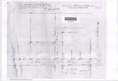
 Eltham District Historical Society Inc
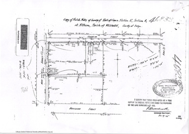
Document - Photocopy, Survey Fleld Notes of Part of Crown Portion 13, Section 4 at Eltham, Parish of Nillumbik, County of Evelyn, 1902-1903
Main Road, Henry Street to Diamond Street; Silver Street to Bible Street Application No. 0337771902, 1903, arthur street, bible street, bird street, diamond creek (creek), diamond street, eltham, eltham railway station, henry street, main road, silver street, survey plan, vine street, application 33777, map -
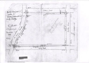
 Eltham District Historical Society Inc
Document - Photocopy, Survey Fleld Notes of Part of Crown Portion 13, Section 4 at Eltham, Parish of Nillumbik, County of Evelyn, 18 May 1908
Portion of land bounded by: Main Road, Luck Street, Bible Street, Arthur Street Application 37314 W. P. Steane, M.C.E. Civil Engineer and Surveyor, 18 May 1908application 37314, arthur street, bible street, eltham, luck street, main road, map, survey plan -
 Eltham District Historical Society Inc
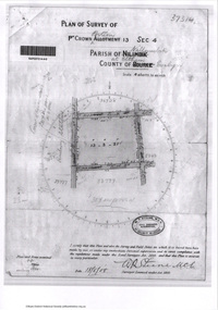
Document - Photocopy, Survey Fleld Notes of Part of Crown Portion 13, Section 4 at Eltham, Parish of Nillumbik, County of Evelyn, 31 May 1907
Portion of land east of Main Road and north of Luck Street bounded by Bible Street Application 36708 K. Arndt, Licensed Surveyor, 31 May 1907application 36708, bible street, eltham, luck street, main road, map, survey plan -
 Eltham District Historical Society Inc
Document - Photocopy, Survey Fleld Notes of Part of Crown Portion 13, Section 4 at Eltham, Parish of Nillumbik, County of Evelyn, November 1909
Portion of land bounded by Main Road, Arthur Street, Bible Street, Henry Street Application 36708 K. Arndt, Licensed Surveyor, November 1909application 5289, arthur street, bible street, eltham, henry street, main road, map, survey plan -
 Eltham District Historical Society Inc
Document - Photocopy, Survey Fleld Notes of Part of Crown Portion 12, Section 4 at Eltham, Parish of Nillumbik, County of Evelyn, 12 October 1910
Portion of land bounded by: Main Road, John Street, Bible Street, Pitt Street Application 38858 K. Arndt, Licensed Surveyor, 12 August 1910application 38858, bible street, eltham, john street, main road, map, pitt street, survey plan -
 Eltham District Historical Society Inc
Document - Photocopy, Survey Fleld Notes of Part of Crown Portion 12, Section 4 at Eltham, Parish of Nillumbik, County of Evelyn, 20 May 1911
Portion of land bounded by: Main Road, York Street, Bible Street, Bridge Street Application 38629 Frederick Dudley Smith, M.C.E. Licensed Surveyor, 20 May 1911application 38629, bible street, bridge street, eltham, main road, map, survey plan, york street -
 Eltham District Historical Society Inc
Document - Photocopy, Survey Fleld Notes of Part of Crown Portion 13, Section 4 at Eltham, Parish of Nillumbik, County of Evelyn, 7 January 1924
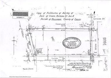
Portion of land north of Luck Street bounded by: Main Road, Bible Street Application 9991 R. Woodstock, Land Surveyor, 7 January 1924application 9991, bible street, eltham, luck street, main road, map, survey plan -
 Eltham District Historical Society Inc
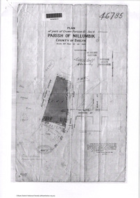
Document - Photocopy, Survey Fleld Notes of Part of Crown Portion 13, Section 4 at Eltham, Parish of Nillumbik, County of Evelyn, 7 May 1925
Portion of land bounded by: Main Road, Eltham Railway Station Application 46785 J.T. Robinson, Surveyor, 7 May 1925application 46785, arthur street, bible street, eltham, eltham railway station, luck street, main road, map, survey plan -
 Eltham District Historical Society Inc
Document - Photocopy, Survey Fleld Notes of Part of Crown Portion 12, Section 4 at Eltham, Parish of Nillumbik, County of Evelyn, 30 September 1925
Portion of land bounded by: Main Road, Franklin Street, Bible Street, Brougham Street Application 46839 R. Woodcock, Licensed Surveyor, 30 September 1925application 46839, bible street, brougham street, eltham, franklin street, main road, map, survey plan -
 Eltham District Historical Society Inc
Survey Fleld Notes of Part of Crown Portion 13, Section 4 at Eltham, Parish of Nillumbik, County of Evelyn, 17 May 1926
Portion of land bounded by: Eltham Railway Station, Main Road, Luck Street, Arthur Street Application 4182/215 J.T. Robinson, Licensed Surveyor, 17 May 1926application 4182/215, arthur street, eltham, eltham railway station, luck street, main road, map, survey plan -
 Eltham District Historical Society Inc
Document - Photocopy, Survey Fleld Notes of Part of Crown Portion 12, Section 4 at Eltham, Parish of Nillumbik, County of Evelyn, 18 March 1926
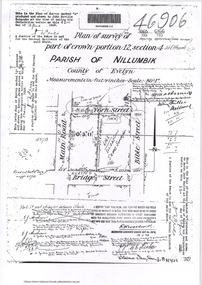
Portion of land bounded by: Main Road, York Street, Bible Street, Bridge Street Application 46906 R.H. Woodcock, Licensed Surveyor, 18 March 1926application 46906, bible street, bridge street, eltham, main road, map, survey plan, york street -
 Eltham District Historical Society Inc
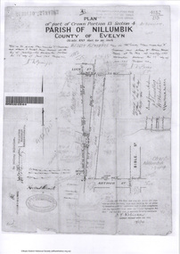
Document - Photocopy, Survey Fleld Notes of Part of Crown Portions 12 & 13, Section 4 at Eltham, Parish of Nillumbik, County of Evelyn, 6 May 1929
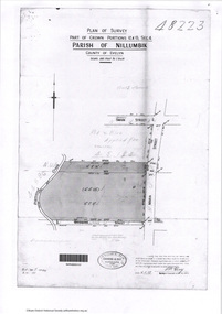
Portion of land bounded by: Main Road, York Street, Diamond Creek, Swan Street Application 48223 P.N. Guy, Licensed Surveyor, 6 May 1929application 48223, diamond creek (creek), eltham, main road, map, survey plan, swan street, york street -
Eltham District Historical Society Inc
Document - Folder, Prentice, Jeff
Jeff Prentice attended Eltham Primary School 1946-1952. Contents Typed manuscript: "School Days at Eltham Primary" by Jeff Prentice. Letter: Jeff Prentice to Eltham District Historical Society, 1 March 2005. Plans to write a history of Eltham. Newsletter, Eltham District Historical Society, No 173, March 2007. Jeff Prentice's memories of Eltham Primary School days.Newspaper clippings, A4 photocopies, etcjeff prentice, eltham primary school, john arnaud, alan pitman, chris jarvis, ken docherty, max forster, sydney stevenson, david bell, braidwood arthur street eltham, adlingtons paddock eltham, stan jobbing