Showing 69 items
matching military organisations of australia
-
 Woodend RSL
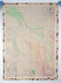
Map, Afghanistan South Western Oruzgan Helmad and Kandahar Province’s July 2009, September 2009
Map was used by Alan Mitchell-Lapin during patrols with Commando Regiment. Alan Mitchell-Lapin is a resident of Woodend.Alan Mitchell-Lappin is a member of the Woodend RSL who served with the Commandos in Afghanistan. Alan was awarded a Commendation for Gallantry for his service in Afghanistan. The map was utilised by Alan during his patrols.Patrol map for South Western Orguzgan Helmand and Kandahar Province’s. Scale 1:200,000. Produced by Australian Government Department of Defence Intelligence and Security. Table top right -Military Legend. Tables middle right - Language distribution, and translation glossary. Table bottom right hand corner - Topograhic Legend. Table centre bottom - Grid magnetic Diagrams. Table top left corner - Tarwin Kowt weather infromation.Produced by the Defence Imagery and Geospatial Organisation, Geospatial Analysis Centre, September 2009. Restricted at time of issue.afghanistan, map, orguzgan, helmand, kandahar, operation slipper, mitchell-lapin, 2009, digo 0098-0910, commando, special forces -
 Melbourne Legacy
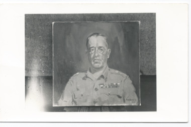
Photograph - Portrait, Lieutenant-General Sir Stanley Savige
Photograph of a painted portrait of L/- Stan Savige. The signature appears to be 'Manders '45'. He appears to be in uniform and could be from his service in World War 2. Stanley Savige is seen as the founder of Legacy when it was founded in Melbourne in September 1923. He was born in Morwell Victoria on 26/6/1890. He served in the Australian Army between 1915 and 1946, including service in both World Wars. Stanley Savige was awarded a KBE, CB, DSO, MC,ED. Stanley George Savige was born in Victoria in 1890, and enlisted in the AIF (Private 577) in March 1915. He served with 24 Battalion at Gallipoli, and was commissioned as a 2nd lieutenant prior to the evacuation, at which he was part of the final holding party at Lone Pine. In France he saw service with 6 Brigade Headquarters as well as with his battalion, and was awarded the Military Cross for his gallantry at the second battle of Bullecourt. In 1918, he became one of a small number of Australians selected for service with 'Dunsterforce' in Persia, commanding 'Urmia Force', and was awarded the Distinguished Service Order. Between the wars, Savige continued his military career with the Militia, and by 1939 he held the rank of colonel. When the 2nd AIF was raised, he was placed in command of 17 Brigade, which he led through the campaigns in Libya, Greece and Syria, before being promoted to command 3 Division (Militia) in New Guinea. In 1944, he was appointed GOC 2 Corps, in command of forces engaged in the campaign on Bougainville, and accepted the Japanese surrender there in September 1945. Lieutenant General Savige was knighted (KBE) in 1950, and died in 1954. He is widely remembered for his efforts between the wars in founding the Legacy Clubs (which he modelled on the 'Remembrance Club' formed in Hobart by his friend and former commander Sir John Gellibrand in 1923) to care for the dependants of deceased servicemen and ex-servicemen. These clubs grew into a nation wide organisation which, by the time of Savige's death, was supporting over 80 000 widows and children.This is a photographic portrait of the founder of the first Legacy Club in Australia, Sir Stanley Savige.Black and white photo of a painting of Sir Stan Savige printed onto a postcard.Stamped with 'Photograph No. MH 91859 Supplied by Military History Section (S.D.9,) General Staff L.H.Q. For official purposes ONLY, NOT TO BE PUBLISHED' in purple ink.savige, portrait, stan savige, founding legatees -
 Bendigo Military Museum
Photograph - AUTOMAP 1 Production – Army Survey Regiment, Fortuna, Bendigo, c1978-1980
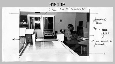
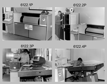
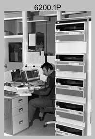
This collection of 20 photos was most likely taken in c1978. The AUTOMAP 1 computer assisted cartography and mapping system was introduced in 1975. The components of AUTOMAP 1 were the Input Sub-System of four Wild B8s stereoplotters and three Gradicon digitising tables, the Optical Line Following Sub-System – Gerber OLF, the Verification Sub-System – Gerber 1442 drum plotter, the General Purpose Sub-system – HP21MX computer and the Output Sub-System – Gerber 1232 flatbed plotter). The first map was published in 1978 (Strickland 3665-3, 1:50,000). AUTOMAP 1 was the first computer assisted cartography and mapping system utilised by the Survey Corps and was the first system used by Australian mapping organisations. The history of the AUTOMAP 1 system is covered in more detail with additional historic photographs, in pages 116-118 of Valerie Lovejoy’s book 'Mapmakers of Fortuna – A history of the Army Survey Regiment’ ISBN: 0-646-42120-4. See items 6122.20P, 6410.24P, 6183.19P, 6200.5P, and 6222.17P for additional photographs of the AUTOMAP 1 system.This is a set of 20 photographs of Air Survey Squadron military and civilian personnel operating AUTOMAP 1 equipment at the Army Survey Regiment at Fortuna, Bendigo, c1978-1980. Black and white photos .1P to .18P are on photographic paper and were scanned at 300 dpi. Photo .4P is in colour and mounted with a duplicate on manilla card. Black and white photos .19P to .20P are on 35mm negative film and scanned at 96 dpi.They are part of the Army Survey Regiment’s Collection. .1) - Photo, black & white, c1978-1980, Gerber Optical Line Follower (OLF), SSGT John Bennett. .2) - Photo, black & white, c1978-1980, HP21MX computer General Purpose Sub-system. .3) - Photo, black & white, c1978-1980, Gerber OLF .4) - Photo, colour, c1978-1980, unidentified digitising on Gradicon edit table. .5) - Photo, black & white, c1978-1980, Gerber verification drum plotter. .6) - Photo, black & white, c1978-1980, Gerber OLF, CAPT Rob Bridge. .7) - Photo, black & white, c1978-1980, Programming and system administration, SGT Alan Toogood. .8) - Photo, black & white, c1978-1980, Unidentified digitising on Gradicon edit table. .9) - Photo, black & white, c1978-1980, CPL Rick Downie digitising on Gradicon edit table. .10) - Photo, black & white, c1978-1980, SPR Dave Irving digitising on Gradicon edit table. .11) - Photo, black & white, c1978-1980, Gerber OLF and CPL Rick Downie. .12) - Photo, black & white, c1978-1980, 1130 Computer System administration, L to R: unidentified, SSGT Les Dixon, SPR Geoff Havelberg. .13) - Photo, black & white, c1978-1980, AUTOMAP 1 tape administration, Maryanne De Groot. .14) - Photo, black & white, c1978-1980, AUTOMAP 1 tape drive. .15) - Photo, black & white, c1978-1980, HP21MX computer General Purpose Sub-system. .16) - Photo, black & white, c1978-1980, digitising topographic features with a Wild B8 stereo plotter, L to R: unidentified, CPL John Smith. .17) - Photo, black & white, c1978-1980, digitising topographic features with a Wild B8 stereo plotter, CPL John Smith. .18) - Photo, black & white, c1978-1980, digitising topographic features with a Wild B8 stereo plotter, CPL Adrian Rynberk. .19) - Photo, black & white, c1978-1980, Programming and system administration, SGT Alan Toogood. .20) - Photo, black & white, c1978-1980, Gerber OLF, CPL Chris Edwards. .1P to .20P - No personnel are identified.royal australian survey corps, rasvy, army survey regiment, army svy regt, fortuna, asr, automap 1 -
 Bendigo Military Museum
Photograph - AUTOMAP 1 Production – Army Survey Regiment, Fortuna, Bendigo, c1978-1980
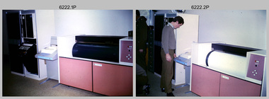
This collection of 17 photos was most likely taken in c1978-1980. The AUTOMAP 1 computer assisted cartography and mapping system was introduced in 1975. The components of AUTOMAP 1 were the Input Sub-System of four Wild B8s stereoplotters and three Gradicon digitising tables, the Optical Line Following Sub-System – Gerber OLF, the Verification Sub-System – Gerber 1442 drum plotter, the General Purpose Sub-system – HP21MX computer and the Output Sub-System – Gerber 1232 flatbed plotter). The first map was published in 1978 (Strickland 3665-3, 1:50,000). AUTOMAP 1 was the first computer assisted cartography and mapping system utilised by the Survey Corps and was the first system used by Australian mapping organisations. The history of the AUTOMAP 1 system is covered in more detail with additional historic photographs, in pages 116-118 of Valerie Lovejoy’s book 'Mapmakers of Fortuna – A history of the Army Survey Regiment’ ISBN: 0-646-42120-4. See items 6122.20P, 6410.24P, 6183.19P, 6184.20P, and 6200.5P for additional photographs of the AUTOMAP 1 system.This is a set of 17 photographs of Air Survey Squadron military and civilian personnel operating AUTOMAP 1 equipment at the Army Survey Regiment at Fortuna, Bendigo, c1978-1980. The photographs were on 35mm colour slides and were scanned at 96 dpi. They are part of the Army Survey Regiment’s Collection. .1) - Photo, colour, c1978-1980, Gerber 1442 verification drum plotter. .2) - Photo, colour, c1978-1980, Gerber 1442 verification drum plotter, SPR Garry Ames. In background - Hewlett Packard (HP) 2100A Minicomputer Input Subsystem controlling Wild B8 Aviograph stereo plotters. .3) - Photo, colour, c1978-1980, Gerber 1442 verification drum plotter. .4) - Photo, colour, c1978-1980, digitising topographic features with a Wild B8 Aviograph stereo plotter, CPL Adrian Rynberk. .5) to .6) - Photo, colour, c1978-1980, Wild PEB8 stereo profiler. .7) - Photo, colour, c1980, HP 9640A Programming System. .8) - Photo, colour, c1980, HP 9640A Programming System, L to R: unidentified, SGT Alan Toogood. .9) - Photo, colour, c1978-1980, Gerber Optical Line Follow (OLF), CAPT Rob Bridge. .10) - Photo, colour, c1978-1980, Gerber OLF. .11.) to .12) - Photo, colour, c1978-1980, Gerber OLF, SPR Gerry Gunn. .13) - Photo, colour, c1978-1980, Gerber OLF. .14) - Photo, colour, c1979, Gradicon edit table. .15) to .16) - Photo, colour, c1981, Gradicon edit table, SPR Chris Gordon. .17) - Photo, colour, c1981, Gradicon edit table, L to R: SPR Chris Brown, unidentified..1P to .17P - Some of the equipment is annotated on the frame of the 35mm slides.royal australian survey corps, rasvy, army survey regiment, army svy regt, fortuna, asr, automap 1 -
 Bendigo Military Museum
photograph - AUTOMAP 1 Production – Army Survey Regiment, Fortuna, Bendigo, c1980
This collection of 20 photos was most likely taken in 1980. The AUTOMAP 1 computer assisted cartography and mapping system was introduced in 1975. The components of AUTOMAP 1 were the Input Sub-System of four Wild B8s stereoplotters and three Gradicon digitising tables, the Optical Line Following Sub-System – Gerber OLF, the Verification Sub-System – Gerber 1442 drum plotter, the General Purpose Sub-system – HP21MX computer and the Output Sub-System – Gerber 1232 flatbed plotter). The first map was published in 1978 (Strickland 3665-3, 1:50,000). AUTOMAP 1 was the first computer assisted cartography and mapping system utilised by the Survey Corps and was the first system used by Australian mapping organisations. The history of the AUTOMAP 1 system is covered in more detail with additional historic photographs, in pages 116-118 of Valerie Lovejoy’s book 'Mapmakers of Fortuna – A history of the Army Survey Regiment’ ISBN: 0-646-42120-4. See items 6410.24P, 6183.19P, 6184.20P, 6200.5P, and 6222.17P for additional photographs of the AUTOMAP 1 system.This is a set of 20 photographs of Air Survey Squadron military and civilian personnel operating AUTOMAP 1 equipment at the Army Survey Regiment at Fortuna, Bendigo, c1980. The photographs were on 35mm negative film and were scanned at 96 dpi. They are part of the Army Survey Regiment’s Collection. Photos .19P and .20P are printed on photographic and scanned at 300 dpi. .1) - Photo, black & white, c1980, Gerber plotter. .2) - Photo, black & white, c1980, Gerber plotter, LT Rob John .3) - Photo, black & white, c1980, Gradicon edit table, SPR Jamie McRae .4) - Photo, black & white, c1980, Gradicon edit table, SPR Steve Linane .5) - Photo, black & white, c1980, 1130 System administration, unidentified. .6) - Photo, black & white, c1980, Wild B8 stereo plotter, SPR Van Dalen? .7) - Photo, black & white, c1980, Wild B8 stereo plotter, SPR Van Dalen? .8) - Photo, black & white, c1980, Gerber Optical Line Follower (OLF). .9) - Photo, black & white, c1980, Gerber OLF. .10) - Photo, black & white, c1980, Gerber OLF. .11) - Photo, black & white, c1980, Gerber OLF. .12) - Photo, black & white, c1980, Gerber OLF. .13) - Photo, black & white, c1980, Data management, CPL Greg Gilbert. .14) - Photo, black & white, c1980, Data management, CPL Greg Gilbert. .15) - Photo, black & white, c1980, 1130 Operating System administration, SGT Denis Marshall. .16) - Photo, black & white, c1980, Programming System, L to R: unidentified, SGT Alan Toogood. .17) - Photo, black & white, c1980, Programming System, L to R: Robert Cox, WO1 Bob Mason, John Dean. .18) - Photo, black & white, c1980, Programming System, L to R: Robert Cox, WO1 Bob Mason, John Dean. .19) - Photo, black & white, c1980, Gradicon edit table, CPL Chris Carter. .20) - Photo, black & white, c1980, Gerber plotter, LT Rob John..1P to .18P - No personnel are identified .19P - ‘CPL Chris Carter’ annotated on backroyal australian survey corps, rasvy, army survey regiment, army svy regt, fortuna, asr, air survey, automap -
 Bendigo Military Museum
Photograph - AUTOMAP 1 Production – Army Survey Regiment, Fortuna, Bendigo, c1979
This collection of 19 photos was most likely taken in 1980. The AUTOMAP 1 computer assisted cartography and mapping system was introduced in 1975. The components of AUTOMAP 1 were the Input Sub-System of four Wild B8s stereoplotters and three Gradicon digitising tables, the Optical Line Following Sub-System – Gerber OLF, the Verification Sub-System – Gerber 1442 drum plotter, the General Purpose Sub-system – HP21MX computer and the Output Sub-System – Gerber 1232 flatbed plotter). The first map was published in 1978 (Strickland 3665-3, 1:50,000). AUTOMAP 1 was the first computer assisted cartography and mapping system utilised by the Survey Corps and was the first system used by Australian mapping organisations. The history of the AUTOMAP 1 system is covered in more detail with additional historic photographs, in pages 116-118 of Valerie Lovejoy’s book 'Mapmakers of Fortuna – A history of the Army Survey Regiment’ ISBN: 0-646-42120-4. See items 6122.20P, 6410.24P, 6184.20P, 6200.5P, and 6222.17P for additional photographs of the AUTOMAP 1 system.This is a set of 19 photographs of Air Survey Squadron military and civilian personnel operating AUTOMAP 1 equipment at the Army Survey Regiment at Fortuna, Bendigo, c1979. The photographs were on 35mm negative film and were scanned at 96 dpi. They are part of the Army Survey Regiment’s Collection. .1) - Photo, colour, c1979, Gradicon edit table, SSGT John Bennett. .2) - Photo, colour, c1979, Gradicon edit table. .3) - Photo, colour, c1979, HP21MX computer General Purpose Sub-system. .4) - Photo, colour, c1979, HP21MX computer General Purpose Sub-system. L to R: CAPT Graham Baker, SPR Ian Belmont. .5) - Photo, colour, c1979, Gerber verification drum plotter. 1130 System administration, unidentified. .6) - Photo, colour, c1979, Gerber Optical Line Follower (OLF). .7) - Photo, colour, c1979, Gerber OLF .8) - Photo, black & white, c1979, Programming and system administration, L to R: WO1 Don Taylor, Robert Cox, Tony Spurling, SSGT John Bennett, SGT Alan Toogood. .9) to .14) - Photo, black & white, c1979, .15) - Photo, black & white, c1979, Gerber OLF, unidentified. .16) - Photo, black & white, c1979, Gerber verification drum plotter, unidentified using Gradicon edit table. .17) to .18) - Photo, black & white, c1979, - Photo, black & white, c1979, Programming and system administration, SSGT John Bennett. .19)- Photo, black & white, c1979, - Photo, black & white, c1979, HP21MX computer General Purpose Sub-system..1P to .19P No personnel are identified.royal australian survey corps, rasvy, army survey regiment, army svy regt, fortuna, asr, automap 1 -
 Bendigo Military Museum
Photograph - AUTOMAP 1 Production – Army Survey Regiment, Fortuna, Bendigo, c1980
This collection of five photos was most likely taken in c1980. The AUTOMAP 1 computer assisted cartography and mapping system was introduced in 1975. The components of AUTOMAP 1 were the Input Sub-System of four Wild B8s stereoplotters and three Gradicon digitising tables, the Optical Line Following Sub-System – Gerber OLF, the Verification Sub-System – Gerber 1442 drum plotter, the General Purpose Sub-system – HP21MX computer and the Output Sub-System – Gerber 1232 flatbed plotter). The first map was published in 1978 (Strickland 3665-3, 1:50,000). AUTOMAP 1 was the first computer assisted cartography and mapping system utilised by the Survey Corps and was the first system used by Australian mapping organisations. The history of the AUTOMAP 1 system is covered in more detail with additional historic photographs, in pages 116-118 of Valerie Lovejoy’s book 'Mapmakers of Fortuna – A history of the Army Survey Regiment’ ISBN: 0-646-42120-4. See items 6410.24P, 6122.20P, 6183.19P, 6184.20P and 6222.17P for more photos of the AUTOMAP 1 computer system.This is a set of five photographs of Air Survey Squadron military personnel operating AUTOMAP 1 equipment at the Army Survey Regiment at Fortuna, Bendigo, c1980. Black and white photos are on photographic paper and were scanned at 300 dpi. They are part of the Army Survey Regiment’s Collection. .1) - Photo, black & white, c1980, SGT Cliff Webb operating AUTOMAP 1 terminal. .2) - Photo, black & white, c1980, HP21MX computer General Purpose Sub-system. .3) - Photo, black & white, c1980, Gerber verification drum plotter. .4) and .5) - Photo, black & white, c1980, unidentified personnel operating AUTOMAP 1 terminal. .1P to .5P - No personnel are identified.royal australian survey corps, rasvy, army survey regiment, army svy regt, fortuna, asr, automap 1 -
 Emerald Museum & Nobelius Heritage Park
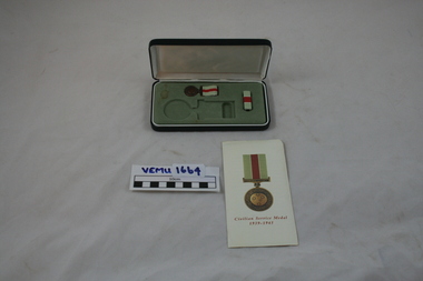
Box of 1 Miniature Medal, 1 Ribbon Bar and one Pamphlet, Miniature Civilian Service Medal and Bar, 1994
The Civilian Service Medal 1939 - 1945 was established in 1994 by the Australian Government. It recognizes the service of civilians who served in Australia during World War 11, in organisations that were subject to military-like arrangements and conditions of service, or arduous circumstances, in support of the war effort. The original medal is missing in the presentation box. The recipient is William George Bennett of the Alice Berry Nursing Home, Kings Rd, Emerald.VEMU1664.1 Civilian Service Medal 1939 - 1945 (minature) with attached ribbon. The ribbon consists of three vertical bands of equal width of green, ochre and green, separated by two narrow white stripes. VEMU1664.2 Ribbon Bar for the Civilian Service Record 1939 - 1945 VEMU1664.3 Pamphlet explaining the medal design and the official wearing of the medalCIVILIAN SERVICE. The medal portrays the Southern Cross surrounded by Golden Wattle. -
 Bendigo Military Museum
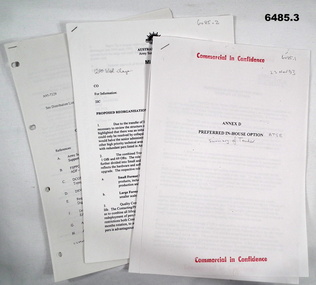
Document - Army Topographic Support Establishment: Preferred In-House Option, 1 23 Nov 1993, .2 30 Nov 1994, .3 14 Jun 1995
.1 The Preferred In-House Option (PIHO) proposes to meet the full requirements of the Request for Tender (RFT) by disestablishing Army Survey Regiment and establishing a new organisation which they have named the Defence Topographic Support Establishment (DTSE). It is proposed to locate the DTSE at Bendigo in the GFE facilities offered by the Commonwealth. The DTSE will be staffed by 140 Defence civilians, principally sourced from ex-RASvy members transferring to the Public Service under the provisions of Section 81B of the Public Service Act. Any existing civilian members excess to DTSE requirements are proposed to be managed within the terms and conditions of the Australian Public Service Redeployment and Retirement (Redundancy) Award 1987. Military members who elect to remain in the Service will be subject to redeployment or retraining in accordance with Service requirements. .2 Proposed re-organisation of Product Construction Squadron (PCS). Due to the transfer of Image and capture Sections to Digital Acquisition Squadron wef Jan 1995 it has been necessary to review the structure of those elements remaining within PCS. The review highlighted that there was an imbalance between Mapping and Digital products Troops. This could only be resolved by collapsing these two Troops into one single production element. This would halve the senior administrative personnel needed thus allowing them to be employed in other higher priority technical areas. The proposed restructure of PCS is outlined in Annex A with redundant personnel listed in Annex B. The combined Troop is to be designated "Construction Troop" and comprises 1 Offr and 69 ORs. The role of this Tp would be to perform all digital production. It is further divided into small and Large Format Sections. This division is functionally based and reflects the hardware and software configurations now resident within the Sqn post system upgrade. .3 During the transition period leading to full implementation of the PHIO, the Army Svy Regt and DTSE (later ATSE) will at times operate concurrently whilst Army Svy Regt scales down production and progressively transfers all technical functions to DTSE. army Svy Regt and 4 Fd Svy Sqn will continue programmed production activities until declared operationally ineffective, however a contingency mapping capability will be maintained throughout the period of implementation. Implementation of the PHIO involves a number of related activities including staff recruitment, equipment acquisition and transfer of technical responsibility. This instruction details the coordination of these and related implementation activities. .1 Preferred In-House Option, Army Topographic Support Establishment. Summary of Tender. 10 x pages typed text and schematic diagrams. .2 Proposed reorganisation - product Construction Squadron. 9 x pages typed text and schematic diagrams. .3 Implementation of the Commercial Support Program (CSP) Digital Topographical support to the Australian Defence Force (ADF). Preferred In-House Option 14 Jun 1995. 22 x pages typed text and schematic diagrams. royal australian survey corps, rasvy, fortuna, army svy reg, army survey regiment, atse