Showing 670 items matching "mine shaft"
-
 Unions Ballarat
Diary of disaster : the New Australasian mine tragedy, Creswick, 1882, Williams, Leonard Murton, 1982
... The Australasian Gold Mine disaster happened in Creswick.... Twenty nine miners were trapped in a gold mine shaft with only ...The Australasian Gold Mine disaster happened in Creswick, Victoria in 1882. Twenty nine miners were trapped in a gold mine shaft with only five rescued - the remainder of the miners drowned.Relevant to the history of Creswick and gold mining in the 1800s. Paper; book.Front cover: author's name and title.btlc, ballarat trades hall, ballarat trades and labour council, creswick, mining, gold mining - creswick, australasian gold mine disaster, miners -
 Bendigo Historical Society Inc.
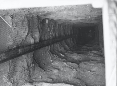
Photograph - AUSTIN COLLECTION: ELEVATOR SHAFT
... Black and white photograph of Central Deborah gold mine... photograph of Central Deborah gold mine elevator shaft. Photograph ...Black and white photograph of Central Deborah gold mine elevator shaft.mining, business, central deborah gold mine -
 Bendigo Historical Society Inc.
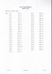
Document - NEW CHUM RAILWAY MINE - DEPTH OF LEVELS OF THE NEW CHUM RAILWAY MINE
... Chum Railway Mine (shaft No 145) showing the depth of each plat... Chum Railway Mine (shaft No 145) showing the depth of each plat ...Handwritten notes and typed copies of same, of the New Chum Railway Mine (shaft No 145) showing the depth of each plat, production of gold, and with the influx of water making operations costly, work ceased in 1910.document, gold, new chum railway mine, new chum railway mine, depth of levels of the new chum railway mine, m d folders etc page 1 -
 Bendigo Historical Society Inc.
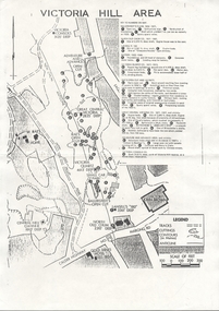
Document - VICTORIA HILL - VICTORIA HILL AREA MAP
... Factory and W Rae's Home. Map also shows mine shafts and open..., John Brown Factory and W Rae's Home. Map also shows mine shafts ...Photocopied map on cream paper. Map is the Victoria Hill area showing the locations of the Gold Mines Hotel, John Brown Factory and W Rae's Home. Map also shows mine shafts and open cuts.map, bendigo, victoria hill, victoria hill map, gold mines hotel, john brown factory, w rae's home, victoria consols, adventure and advance open cut, great central victoria, rae's open cut, victoria qiartz, ballerstedt's open cut, lansell's '180', north old chum, central nell gwynne -
 Bendigo Historical Society Inc.
Document - TYPED NOTES: THE PEARL MINE & MARKET SQUARE
... of the mine (shafts, levels, tonnage etc.). Author - Ken Bice . 2... of the mine (shafts, levels, tonnage etc). Author - Ken Bice . 2 ...Typed notes for RHSV BendigoBranch Newsletter re 1. the Pearl Mine with handwritten annotations. Details of the mine (shafts, levels, tonnage etc). Author - Ken Bice . 2. Market Square (cont.) - then and now - note stating this as 'Personal Research' by ''Joch''.Typed notes for RHSV Bendigo Branch Newsletter re 1. The Pearl Mine with handwritten annotations. Details of the mine (shafts, levels, tonnage etc.). Author - Ken Bice . 2. Market Square (cont.) - then and now - notes stating this as 'Personal Research' by ''Joch''.document, gold, pearl mine -
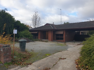 Ballarat Heritage Services
Photograph, Clare Gervasoni, 103 Lyons Street South, Ballarat from outide 105 Lyons Street South, Ballarat Central, 05/2023
... the previous house was demolished an mine shaft was discovered under... was demolished an mine shaft was discovered under the house and had ...In 2023 103 Lyons Street South was sold and left uncared for after being sold in 2022. Later in 2023 it was demolished. The red brick building was built by 103 Lyons Street South, Ballarat, Ballarat Central. 103 Lyons street is a red brick house which was built c1980. When the previous house was demolished an mine shaft was discovered under the house and had to be capped. 103 lyons st south ballarat central, architecture, dot thurling, william thurling -
 Bendigo Historical Society Inc.
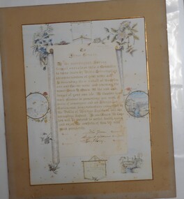
Award - ILLUMINATED ADDESS: JAMES TONKIN, 1895
... Owen who had fallen down a mine shaft at the Collmann... who had fallen down a mine shaft at the Collmann and Tacchi ...Illuminated Address preented to James Tonkin recognizing bravery when he descended into a mine three times to rescue Owen R Owen who had fallen down a mine shaft at the Collmann and Tacchi Mine in 1895. -
 Bendigo Historical Society Inc.
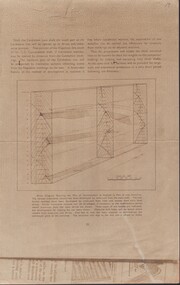
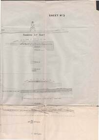
Document - CARSHALTON MINE - BLOCK DIAGRAM SHOWING THE PLAN OF DEVELOPMENT
... PLACE Mining site carshalton mine Carshalton Main Shaft Napoleon ...Beige sheet of paper of Block Diagram Showing the Plan of Development as Applied to Part of one Anticline. The diagram goes down for 20 levels. Also mentions the Napoleon Line and the G. G. Consolidated Shaft.place, mining site, carshalton mine, carshalton main shaft, napoleon line, g. g.consolidated shaft, block diagram showing the plan of development as applied to part of one anticline -
 Bendigo Historical Society Inc.
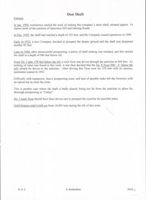
Document - DON SHAFT - NOTES ON THE DON SHAFT
... Inc. History House 11 Mackenzie Street Bendigo goldfields MINE ...Hand written notes on the Don Shaft situated approximately 14 chains north of the junction of Specimen Hill and Marong Roads. Notes include dates and depth of shaft, shere x cuts were driven and gold returns.mine, gold, don shaft, don shaft, notes on the don shaft, gold returns -
 Bendigo Historical Society Inc.
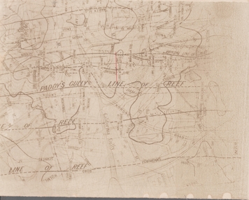
Map - GOLDFIELD MAP
... of Reef North Johnson Shaft Mine Shafts Portion of the map ...Portion of the map of the Bendigo Goldfield with the Paddy's Gully Line of Reef near the centre. Streets, contours and gullies are included. Underlined in red is the North Johnson Shaft.map, bendigo, goldfields, goldfield map, paddy's gully line of reef, north johnson shaft, mine shafts -
 Bendigo Historical Society Inc.
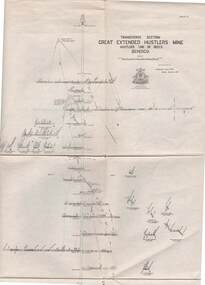
Map - GREAT EXTENDED HUSTLER'S MINE - PLAN OF THE GREAT EXTENDED HUSTLER'S MINE
... MINING Parish Map Great Extended Hustler's Mine No 2 Shaft ...Plan of the Great Extended Hustler's Mine. Bulletin No 33, Plate No XI. Shows No 2 Shaft, Latham & Watson's Shaft, levels and their depths and some geographical features. Geographical Survey of Victoria emblem and signed by H A Whitelaw, Underground Survey Office, Bendigo, September 1913. Has reference to photos.mining, parish map, great extended hustler's mine, no 2 shaft, latham & watson's shaft, geological survey of victoria, underground survey office bendigo, h a whitelaw -
 Bendigo Historical Society Inc.
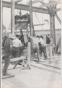
Photograph - Napoleon Gold Mine Cage, 1935
... Mine sinking cage shaft Written in pencil on back of photograph ...Significant to mining history of Bendigo.Black and white photograph: six workmen positioning the metal sinking cage over the Napoleon shaft. Cage is suspended by ropes from the cross beams of the headframe. Two railway tracks leading to shaft, presumably to transport the sinking cage to site. Workman on left hand side has a hammer inserted on his belt.Written in pencil on back of photograph : ' Cage being put in Napoleon shaft 9/3/35'. napoleon gold mine, sinking cage, shaft -
 Bendigo Historical Society Inc.
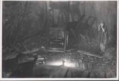
Photograph - Napoleon Main Shaft, 1935
... Mine Mine machinery Plat shaft Written in pencil on back ...Significant to mining history of Bendigo.Black and white photograph: metal mine cage at level in Napoleon mine. Man standing on right hand side looking directly at cage, with both arms raised. Lengths of timber and rock rubble on floor of level. Written in pencil on back of photograph : 'Nap. main shaft 22/6/36 opposite No. 10 plat' napoleon gold mine, mine machinery, plat, shaft -
 Bendigo Military Museum
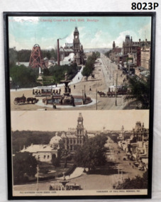
Photograph - CHARING CROSS, PALLMALL SMI, MOUNTED, C.2000
... then. The mine shaft capped sits about centre of the building.... then. The mine shaft capped sits about centre of the building. brsl ...The mine was the “Hustlers Royal Reserve Mine No 2” and was closed in 1912. The Soldiers Memorial Institute was erected on the mine site and opened on 15.11.1921 and occupied by the Bendigo RSL Sub Branch/Bendigo District RSL Sub Branch Inc since then. The mine shaft capped sits about centre of the building.Two gloss coloured prints on fibre board backing. Top photo tinted of Alexander Fountain, Charing Cross and Pall Mall Bendigo. Gold mine poppet head and buildings on left hand side. 53464 VJ printed on R.H.S. bottom. Bottom photo black and white of Panorama of Pall Mall., Bendigo, Vic. Soldiers Memorial on left hand side occupying old gold mine site.“The Southern Cross Series 10399. Copyright on bottom L.H.S. Panorama of Pall Mall, Bendigo on R.H.S. bottom”brsl, smirsl, hustlers -
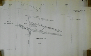 Bendigo Historical Society Inc.
Document - MARKS COLLECTION: LANSELL'S 180 PLAN
... Plan (copy) of Lansell's 180 mine shaft. Plan LH side... 180 mine shaft. Plan LH side is marked with North Old Chum Co ...Plan (copy) of Lansell's 180 mine shaft. Plan LH side is marked with North Old Chum Co. Shaft No. 78, in centre detailed plan of Lansell's 180 shaft, and marked on LH side of plan Victoria Quartz Co., (no detailed plan).bendigo, mining, lansell's 180 mine -
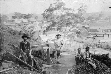 Eltham District Historical Society Inc
Photograph, Early Goldmine
... Four male gold miners pose for the camera on their mine... melbourne Four male gold miners pose for the camera on their mine ...Four male gold miners pose for the camera on their mine site on top of a hill. It appears they are using the underground hard-rock method of mining to extract gold encased in rock. There is a rope winch near by and a pile of rubble on top of the mine shaft. In the background is a developed unknown rural town. "H & J Friend Victoria Stores" is written on the side of a building.This photo forms part of a collection of photographs gathered by the Shire of Eltham for their centenary project book, "Pioneers and Painters: 100 years of the Shire of Eltham" by Alan Marshall (1971). The collection of over 500 images is held in partnership between Eltham District Historical Society and Yarra Plenty Regional Library (Eltham Library) and is now formally known as 'The Shire of Eltham Pioneers Photograph Collection.' It is significant in being the first community sourced collection representing the places and people of the Shire's first one hundred years.Digital imagesepp, shire of eltham pioneers photograph collection, other areas, gold mining, gold miners, h & j friend, winch -
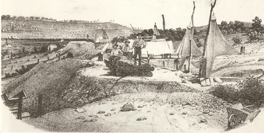 Bendigo Historical Society Inc.
Photograph - MINERS AT VICTORIA REEF, c.1857
... site. Air ventilators on top of mine shafts to R. Wheelbarrow... of mine shafts to R. Wheelbarrow at R foreground. Wind socks ...Black and white photograph of sketch of workmen at mine site. Air ventilators on top of mine shafts to R. Wheelbarrow at R foreground. Wind socks or sails were used to ventilate the holes. History: 'Victoria Reef 1857, Frank Cusack after a photograph by Alex Fox.Alex Foxmine, gold, victoria hill, book 'bendigo, the german chapter' by frank cusack. p52., mines and mining, mine, place, workers, miners, mining equipment, equipment, frank cusack, history -
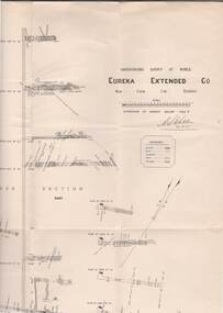 Bendigo Historical Society Inc.
Map - STRUGNELL COLLECTION: UNDERGROUND SURVEY OF MINES, BENDIGO, 29-4-01
... shows mine shaft from 1871 feet to over 3030 feet deep... H.A.Whitelaw 29.4.01 Drawing shows mine shaft from 1871 feet to over ...Map, Underground Survey of Mines, Bendigo.Eureka Extended Co., New Chum Line. Signed H.A.Whitelaw 29.4.01 Drawing shows mine shaft from 1871 feet to over 3030 feet deep and appears to show samples of connecting horizontal shafts with their respective mineral contents.A>S>Whitelawmap, bendigo, eureka extended co. -
 Bendigo Historical Society Inc.
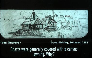
Slide - DIGGERS & MINING. GETTING THE GOLD, c1853
... with canvas awning. Why? Slide shows canvas awnings over mine shafts... canvas awnings over mine shafts. Markings: 25 994.LIF:4. Used ...Diggers & Mining. Getting the Gold. Slide: (von Guerard) Deep Sinking, Ballarat, 1853. Shafts were generally covered with canvas awning. Why? Slide shows canvas awnings over mine shafts. Markings: 25 994.LIF:4. Used as a teaching aid.hanimounteducation, tertiary, goldfields -
 Bendigo Historical Society Inc.
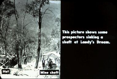
Slide - DIGGERS & MINING. DIGGERS AND MINERS, c1800s
... . Hut on left and mine shaft to the right. In this photo... sinking a shaft at Landy's Dream. Hut on left and mine shaft ...Diggers & Mining. Diggers and miners. Walhalla - Gold Town. This picture shows some prospectors sinking a shaft at Landy's Dream. Hut on left and mine shaft to the right. In this photo there are still many tall trees around. Markings: 11 995 WAL. Used as a teaching aid.hanimounteducation, tertiary, goldfields -
 Bendigo Historical Society Inc.
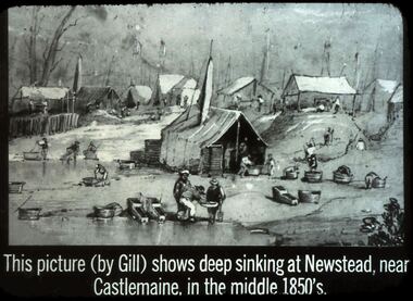
Slide - DIGGERS & MINING. GETTING THE GOLD, c1850s
... , awnings erected over mine shafts in the background. Markings: 40... miners puddling and panning for gold, awnings erected over mine ...Diggers & Mining. Getting the Gold. Slide: This picture (by Gill) Shows deep sinking at Newstead, near Castlemaine, in the middle 1850's. Picture shows miners puddling and panning for gold, awnings erected over mine shafts in the background. Markings: 40 994.LIF:4. Used as a teaching aid.haniomunteducation, tertiary, goldfields -
 Stawell Historical Society Inc
Photograph, Pleasant Creek Cross Reef Quartz Mine Stawell. Holterman Photograph 1874
... On left is Pleasant Creek Cross Reef Mine No1 Shaft, (1300... grampians On left is Pleasant Creek Cross Reef Mine No1 Shaft, (1300 ...On left is Pleasant Creek Cross Reef Mine No1 Shaft, (1300 feet deep) and on right is No2 Shaft (1200 feet deep)Holtermann Black and White photographs of Stawell. April 1874. Poppet Head and winding house of Mine with town in background. Workers can be seen in centre of photo and standing on poppet head and handling ore trolleys on tramway.mining -
 Bendigo Historical Society Inc.
Map - STRUGNELL COLLECTION: UNDERGROUND SURVEY OF MINES BENDIGO
... mine shafts to over 3100 feet deep... of Mines, Bendigo, New Chum Railway Reef, Shenandoah Co's Shaft ...Map, Underground Survey of Mines, Bendigo, New Chum Railway Reef, Shenandoah Co's Shaft, Shamrock Co's Shaft.Young Chum Reef, Thorpe's Reef, Shenandoah Reef, Consolidated Reef, Sheet 3.Survey under the Supervision of H.Herman. Drawing shows mine shafts to over 3100 feet deepmap, bendigo, shamrock & shenandoah co's -
 Bendigo Historical Society Inc.
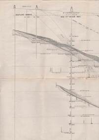
Map - STRUGNELL COLLECTION: HUSTLER'S LINE OF REEFS, BENDIGO, September 1913
... shows mine shaft to over 3454 feet deep and appears to show... 1913 Drawing shows mine shaft to over 3454 feet deep ...Map, Hustler's Line of Reefs, Great Extended Hustler's Mine, Longitudinal Section Plate No X111 (13). Bulletin No 33 Signed H.A.Whitelaw Underground survey Office Bendigo September 1913 Drawing shows mine shaft to over 3454 feet deep and appears to show samples of connecting horizontal shaftsUnderground Survey Office, Bendigo.map, bendigo, great extended hustler's mine -
 Bendigo Historical Society Inc.
Map - STRUGNELL COLLECTION: HUSTLER'S Royal Reserve Shaft No. 2 Bendigo, September 1913
... 1913 Drawing shows mine shaft to over 1746 feet deep... Bendigo September 1913 Drawing shows mine shaft to over 1746 feet ...Map, Hustler's Line of Reef, Hustler's Royal Reserves No. 2 Co, Longitudinal Section.Plate No.V111 (8). Bulletin No 33 Signed H.A.Whitelaw Underground survey Office Bendigo September 1913 Drawing shows mine shaft to over 1746 feet deep and appears to show samples of connecting horizontal shaftsUnderground Survey Office, Bendigo.map, bendigo, hustler's royal reserve no. 2 mine* -
 Bendigo Historical Society Inc.
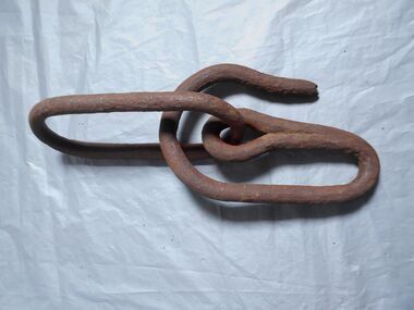
Functional object - Bucket hooks
... Two bucket hooks made of metal used in mine shafts, one... bucket hooks Minning Two bucket hooks made of metal used in mine ...Two bucket hooks made of metal used in mine shafts, one is a swivel hook that will open and close to lock on the bucket on to it. The other is an open hook that is attached to a chain. a; hook in closed position so the bucket can't come out. b; hook in open position to put the bucket on to the hook c; hook attached to a chain bucket hooks, minning -
 Robin Boyd Foundation
Document - Script, Robin Boyd, The Flying Dogtor. Episode 12 Caught!, 1963
... . He slipped into an old mine shaft and planned his next trap.... He slipped into an old mine shaft and planned his next trap ...There was an enormous crash and Crafty thought he had finally squashed the Dogtor but he was not harmed when the great stone fell, using his stethoscope to open the door. Crafty was hiding behind a shed in the yard waiting for the dust to settle. The Dogtor used his teeth to catch Crafty by the end of his tail but Crafty twisted and escaped through an opening in the back fence. He slipped into an old mine shaft and planned his next trap for the Dogtor.The Flying Dogtor" series was broadcast on Australian Television Network (later becoming the Seven Network) between February and April 1964 (see item D254 for schedule).Typewritten, carbon copy, foolscap, 3 pagesthe flying dogtor, robin boyd, crawford productions, manuscript -
 Bendigo Historical Society Inc.
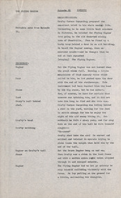
Newspaper - JENNY FOLEY COLLECTION: POWERFUL
... the cages in the main mine shaft. Cages were used to transport... machinery which lowered and raised the cages in the main mine shaft ...Bendigo Advertiser ''The way we were'' from 2000. Powerful: steam-driven winding machinery which lowered and raised the cages in the main mine shaft. Cages were used to transport miners to and from their shifts at various levels and to transport buckets of ore, timber and even animals from the different working levels of the mine. The clip is in a folder.newspaper, bendigo advertiser, the way we were -
 Bendigo Historical Society Inc.
Book - MCCOLL, RANKIN AND STANISTREET COLLECTION: EAST CLARENCE GOLD MINING CO. - LEDGER, 1940/51
... from Mines Department recovering costs covering the mine shaft... covering the mine shaft. East Clarence Gold Mining Company ...Book; Hardbound ledger book with entries from 19/4/1940 to 24/1/1941. Loose documents in back of book, workings. Notice of general meeting 28/10/1949, invoices and expense sheets, letter from Mines Department recovering costs covering the mine shaft. East Clarence Gold Mining Company No Liability.MCCOLL RANKIN & STANISTREETorganisation, industry, accounting., mccoll rankin & stanistreet -
 Bendigo Historical Society Inc.
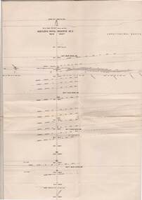
Map - STRUGNELL COLLECTION: HUSTLER'S LINE OF REEFS, BENDIGO, September 1913
... 1913 Drawing shows mine shaft to over 3454 feet deep... September 1913 Drawing shows mine shaft to over 3454 feet deep ...Map, Hustler's Line of Reefs, Great Extended Hustler's Mine, Bendigo, Transverse Section. Plate No. X11 (12). Bulletin No 33 Signed H.A.Whitelaw Underground survey Office Bendigo September 1913 Drawing shows mine shaft to over 3454 feet deep and appears to show samples of connecting horizontal shafts with their respective mineral contentsUnderground Survey Office, Bendigo.map, bendigo, great extended hustler's mine