Showing 66 items matching "mt. evelyn"
-
 Clunes Museum
Document - MT BECKWORTH POST FFICE
.1 MOUNT BECKWORTH (SOMETIMES SPELLED MOUNT BECKWITH) POST OFFICE WAS OPENED ON 1ST MARCH 1863 AS A RECEIVING OFFICE. IT WAS UPGRADED TO POST OFFICE ON 7TH JULY 1927 AND CLOSED ON 14 DECEMBER 1955/ BARRED NUMERAL CANCEL 431, OF WHICH TERE ARE VERY FEW KNOWN, WAS USED AT MOUNT BECKWORTH UNTIL CIRCULAR DATE STAMPS REPLACED THEM IN 1912 POST OFFICERS AT MOUNT BECKWORTH WERE J MCLEAN 1863-1864 THOMAS DUNN 1864-1909 B DUNN 1909-1911 R. DUNN 1911-1920 MISS CAMERON 1920-1936 MISS EVELYN CAMERON DUNN 1936-1939 BERTHA AMELIA DORIS ALSTON 1939 MRS. EVELYN CAMERON ROMEO 1939-1955 .2 LETTER FROM ALEX STONEMAN SENDING INFORMATIONS ABOUT THE HISTORY OF pOST OFFICES IN THE AREA, A PHOTOCOPY OF PART OF THE RAILWAY AND POSTAL & TELEGRAPH MAP OF VICTORIAmt beckworth post office, mount beckwith post office -
 Rutherglen Historical Society
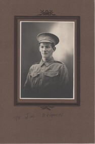
Image, 1914 to 1918 (Exact)
Black and white photograph of a soldier in uniform. Photo mounted on brown cardboard.On the bottom of the mount: "Spr Jim Braybon" On back of photo: "Spr Jim Braybon to the nuns of Rutherglen Convent with kind regards from Spr J.E. Braybon 21/13 ALH"jim braybon, mt carmel convent, rutherglen convent, australian light horse, soldiers, ww1, world war 1, wwi, world war i, presentation sisters, james braybon, frank braybon, francis braybon, mary braybon, evelyn kettle -
 Mt Dandenong & District Historical Society Inc.
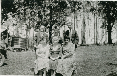
Photograph, Group at the Log Cabin
The Log Cabin Cafe was built by Jack Dodd for Miss Agnes Portelli in 1926. Miss Portelli ran the Log Cabin for many years with assistance from her niece, Evelyn Earney (nee Anstey) and other local girls. The photograph shows Evelyn Earney (LHS), Agnes Portelli (Centre) with unnamed visitors.mount dandenong, log cabin, agnes portelli, jack dodd, evelyn earney -
 Falls Creek Historical Society
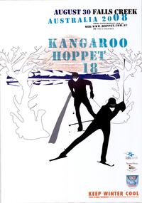
Poster - Kangaroo Hoppet 2008
The Kangaroo Hoppet is Australia’s premier long distance cross country ski race, and a member of the Worldloppet series of international cross country ski events. The first race at Falls Creek was held in 1979 under the name of “Australian Birkebeiner”. It was a 21km race with about 80 participants organised by the Birkebeiner Nordic Ski Club of Mount Beauty. The course started and finished at Falls Creek Alpine Resort and took participants out into the Bogong High Plains. After running the event for 10 years, it was decided they should become part of the Worldloppet series of marathon ski races. Representatives from the Birkebeiner Nordic Ski Club and the Australian Ski Federation attended the Worldloppet Annual Meeting in Finland in June 1990 to put the case for the acceptance of an Australian event into the Worldloppet series. Before being admitted, they had to demonstrate that the Birkebeiner Club could run a world class event, so three months later in August 1990 a 42km event named the Australian International Ski Marathon was held at Falls Creek together with a 21km Birkebeiner race and a 7km event called the Birkebeiner Lite. The event was approved by delegates from USA, Norway and Austria, in 1991 Australia became the 12th member of Worldloppet, with the condition that there had to be a name change. After some late night discussion allegedly involving red wine from North East Victoria the main event became the 42km Kangaroo Hoppet, with the minor events being the 21km Australian Birkebeiner, and 7km Joey Hoppet. In the winter of 1991, the first Kangaroo Hoppet was held. It was a great success and has been a regular fixture on the international ski calendar ever since. It features the main 42km event as well as a 21km event and a 7km event. The Hoppet brings the Australian snowfields to an international audience. In 2008 the Men's Winner was Ben Sim from Australia in a time of 1:42:16. The winner of the Women's event was Evelyn Dong of USA in a time of 2:00:35. This poster is significant because it documents an event which brings international attention to Falls Creek and the surrounding region.A poster with an image of two stylised skiers in black moving between trees towards the audience. The red sun in the background is composed by repetition of horizontal red lines of the words "KANGAROO HOPPET 18 AUGUST 30 FALLS CREEK AUSTRALIA." The logos of Falls Creek, Tourism Victoria and Worldloppet are on the bottom right hand side. text is in blue and black.At the top: AUGUST 30 FALLS CREEK AUSTRALIA 2008 KANGAROO HOPPET 18 Email: [email protected] WEB: www.hoppet.com.au PH: +61 3 57541045kangaroo hoppet, worldloppet events, falls creek, mt. beauty -
 Eltham District Historical Society Inc
Photograph - Digital Photograph, Alan King, Kinglake National Park, 27 March 2008
Fern gullies around Jehosaphat Gully Covered under National Estate. Published: Nillumbik Now and Then / Marguerite Marshall 2008; photographs Alan King with Marguerite Marshall.; p125 The magnificent Kinglake National Park, fringing Nillumbik’s north, is the largest national park close to Melbourne. Thanks to the vision and hard work of a band of local people, the park was created from what was rapidly becoming degraded land. Seeing a threat to Kinglake’s indigenous flora and fauna, several prominent local people campaigned for a national park, which was established in 1928.1 Since then, the park has grown through donations and acquisitions of land, from around 13,800 acres of land (5585ha) to 22,360 hectares. The Sugarloaf and Everard Blocks – of almost 8000 hectares – stand in Nillumbik and the park extends into Mitchell and Murrundindi Shires and the City of Whittlesea. Mt Everard commemorates William Hugh Everard, State member for Evelyn when the park was established. Before 1928, European settlers had degraded the Kinglake area, which was named after the celebrated English author and lawyer, Alexander William Kinglake. Remains of gold shafts and diggings in the park are reminders of Kinglake’s first settlers, who hoped to strike it rich at the gold diggings. But like other gold fields in this shire, they proved not very lucrative and soon timber cutting replaced mining in importance. However, before long, the accessible timber supply ran out, so in the 1920s agriculture took over – particularly potatoes and berry fruits – which involved large-scale clearing.2 The park’s instigator was retired Melbourne University Professor of Music, William Laver.3 As chair of the Kinglake Progress Association he began negotiations to have crown lands on the southern scarp of the Great Dividing Range reserved as a national park. Even before the park was proclaimed, from 1927, KPA members cut tracks to the major scenic points. Professor Laver was one of several people who gave land for the park, donating around 50 acres (20ha), including the Jehosaphat Gully.4 Laver chaired the park’s first Committee of Management, which raised money to employ a ranger and provide facilities, including tracks and roads for fire protection vehicles, toilets and shelters. The committee charged fees for firewood collection, some grazing of livestock, and visitor entrance, and obtained small State Government and Eltham Shire grants. In 1957 the State Government provided revenue for national parks. Then, in 1975, the State Government took over the management and the Committee of Management became an advisory committee, which disbanded in 1978. Originally, the park covered crown land in the Shires of Eltham and Whittlesea; then Wombelano Falls in Yea and other areas were added. In 1970 the park extended into the Shires of Eltham, Healesville, Whittlesea and Yea.5 Bush fires have been an ongoing problem. In 1939 hundreds of eucalypts and acacias had to be sown around the Jehosaphat Gully to rejuvenate the forest. To manage bushfires, the Committee of Management, then the State Government, worked closely with the Forestry Commission, shire councils and local fire brigades. Early national parks focussed on recreation. But by the 1980s, conservation, education and scientific research became more important, playing a vital role in preserving representative samples of the natural environment. Each year many thousands of people use the park’s extensive network of walking tracks amongst the protected plant and animal life as well as camping, cycling and horse riding. The park, along the slopes of the Great Dividing Range, has lookouts revealing magnificent views of the Melbourne skyline, Port Phillip Bay, the Yarra Valley and the You Yangs. Vegetation in the Masons Falls area includes messmate forest, Austral grass-trees, ferns and Hazel Pomaderris. In spring, orchids, lilies, everlasting daisies, correas, grevillea and heath appear. Around Jehosaphat Gully are wet and dry forest, fern gullies and banksia. Animal life includes wallabies, kangaroos, koalas, echidnas, possums, gliders and bandicoots. Male lyrebirds can be heard mimicking in the Jehosaphat Gully, particularly in the Everard Block in winter.This collection of almost 130 photos about places and people within the Shire of Nillumbik, an urban and rural municipality in Melbourne's north, contributes to an understanding of the history of the Shire. Published in 2008 immediately prior to the Black Saturday bushfires of February 7, 2009, it documents sites that were impacted, and in some cases destroyed by the fires. It includes photographs taken especially for the publication, creating a unique time capsule representing the Shire in the early 21st century. It remains the most recent comprehenesive publication devoted to the Shire's history connecting local residents to the past. nillumbik now and then (marshall-king) collection, kinglake national park, jehosaphat gully -
 Ringwood and District Historical Society
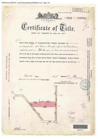
Document, Certificate of Title - Harold Claude Howship, Nurseryman, Ringwood, Vic. - 1928
A4 copies of Landata Victoria Historical Search documents - Vol 5485 Fol 1096804. Harold Claude Howship of Mt. Dandenong Road Ringwood, Nurseryman, is now the proprietor of an Estate in Fee-simple subject to the Encumbrances notified hereunder ... 5 acres 3 roods 10 perches or thereabouts, part of Crown Section Twenty, Parish of Warrandyte, County of Evelyn, together with a right of carriage way over roads coloured brown. Subdivision map includes Wonga Road (later Warranwood Road), Grandview Grove (later Bemboka Road), and Plymouth Road, Ringwood. Proprietors and Transfers include Emily Mills, Plymouth Road Ringwood, Widow - 27th January, 1939. William George Carter, Grandview Grove Warranwod - 14th March, 1947 - 3 acres Evelyn Goudie and Beverley Gwen Goudie, Wonga Road Warranwood - 23rd October, 1950 - 1 acre