Showing 11648 items matching "on the map"
-
 Warrnambool and District Historical Society Inc.
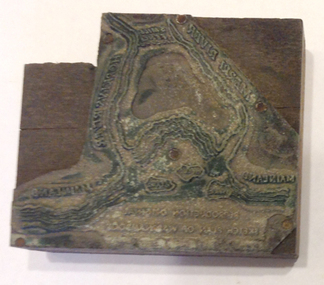
Functional object - Printing block: Warrnambool Historical Society logo, 1980s
This printers block was made for the Warrnambool and District Historical Society and used to print letterheads, envelopes and cards. The impression on the block is of the sketch map drawn by Thomas Price of Port Fairy of the Warrnambool Harbour site when he wrote to Superintendent Charles LaTrobe in 1844 regarding the suitability of the site for a new town. The letter is regarded as an important impetus for La Trobe to consider establishing the town of Warrnambool and so the sketch was used by the Historical Society as its logo on letterheads etc for many years. It was also used as the heading for the Society newsletters from the late 1980s to late 2007.This block of the Thomas Price sketch was used by the Historical Society for many years for its printed material and the sketch was used as its logo for about 20 years so it is an important part of the Society’s history and the block is kept as a reminder of this.This is a printing block with an impression made of metal and attached to a wooden block. The wood is in layers of dark and light coloured wood and has a piece cut out at the top left hand corner. The impression is a representation of the sketch map of Warrnambool Harbour made by Thomas Price in 1844.Sketch map of Warrnambool Harbour 1844warrnambool & district historical society, thomas price sketch -
 Wodonga & District Historical Society Inc
Map - Tulloch & Brown's Map of the Colony of Victoria, Tulloch & Brown, 1856
The map was created by Tulloch and Brown. David Tulloch was one of the earliest engravers and lithographers in the state of Victoria. He arrived in Melbourne from Greenock, Scotland, on 3 January 1849. Following the discovery of gold Tulloch went to the Victorian goldfields in 1851, commissioned to make sketches of the diggers and the diggings for Ham’s Illustrated Australian Magazine. In November 1852 Tulloch set up in business as engraver, draughtsman, copperplate printer and lithographer. Tulloch took a map engraver, James Davie Brown, into partnership in March 1853; the several maps and specimens of commercial engraving they showed at the 1854 Melbourne Exhibition were awarded a bronze medal. That year Tulloch and Brown also received a silver medal at the Victorian Industrial Exhibition. The partnership was dissolved towards the end of 1856.This is a very early map of the Colony of Victoria including Belvoir (now know as Wodonga).A foldable map mounted on linen and with a board cover. It records the Colony of Victoria according to Surveyor's Records revised in 1857. Areas of the map are shaded to highlight different counties.At bottom right hand section of map: Tulloch & Brown's map of the Colony of Victoria : comprising part of New South Wales, the boundaries, counties, also seaport & inland townships, the gold fields with the latest discoveries, roads, tracks, &c. &c. / compiled from drawings in the Survey Office and correctly revised till 1857. Respectfully dedicated by Permission, to the Honorable Captain Andrew Clarke R.E. Surveyor General of Victoria by His Obediant Servants Tulloch & Brown, Engravers & Publishers, Melbourne". At bottom right below border : Published as the Act directs by the Proprietors, Melbourne, 1st Feb. 1856. tulloch and brown maps, rare maps victoria, victorian cartography -
 Melbourne Legacy
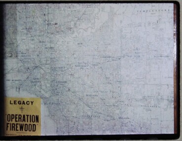
Slide, Operation Firewood, 1960s
Three colour slides of a map of Metropolitan Melbourne with pins showing many delivery addresses. It was during Operation Firewood. Legatees would organise collection of wood from the country and distribute it to widows in metropolitan Melbourne. Other slides show the cutting and loading of wood and delivery to widows in metropolitan Melbourne. Was with many other slides taken in the 1950s and 1960s. The slides have been photographed to make digital images and moved to archive quality sleeves. In many cases the original images were not well focussed and the digital image the best available.A record of Legacy helping widows by sourcing, supplying and delivering firewood. When open fires were the main source of heating, a load of firewood and help moving it, would have been very important to the widows.Colour slide x 3 of a map of Melbourne during Operation Firewood in white cardboard mount.Printed on front in blue ink 'Made in Australia'. Hand written on one slide 'Map of Operation Firewood' in pencil.operation firewood, maps -
 Victorian Aboriginal Corporation for Languages
Book, New South Wales Aboriginal place names and euphonious words, with their meanings, 1959
Includes map of NSW tribes, and numerical cross-referencing to those tribes if the language of the place name is known.Maps, word lists -
 Bendigo Historical Society Inc.
Map - Road maps
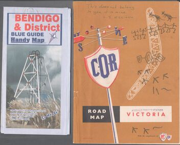
BHS CollectionTwo road maps. On, Bendigo & District blue guide handy map the other a road map of Victoria. On the back of the Bendigo map the date October 2000. On the Victoria map the words in pen "This doesn't belong to you, it is mine". L.J. Ellison and a blue stamp of Axedale service station. Aileen and John Ellison Collection.road map, victoria, bendigo -
 Victorian Aboriginal Corporation for Languages
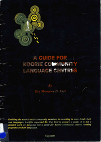
Book, Eve Mumewa D Fesl, A guide for Koorie community Language centres
Looking at maps and word lists that record the use of languages and dialects in the areas. Gives tips for recording languages and language lists.Maps, word listskulin, ganai, wadi wadi, wemba wemba, wergaia, yorta yorta, dadi dadi -
Victorian Aboriginal Corporation for Languages
Book, Leon Costermans, Trees of Victoria and adjoining areas, 1994
Format features leaf identification, map of location, seeds and bark etc., in black and white drawings.Colour photographs, illustrations, mapstrees, east gippsland, south coast nsw, mallee -
 Bendigo Military Museum
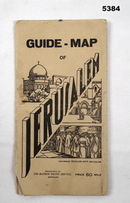
Booklet - GUIDE MAP OF JERUSALEM, The Matson Photo Service,Jerusalem
This item was souvenired by Pte VX 59037 L. E. Anderson, 3rd Aust Ord W. Shops Comp A15, Beirut, SyriaCream cardboard covers with black printing and sketch of buildings and people praying at the wall. Back cover has a map of Syria on the inside. Folded map coloured red and yellow on cream paper. Back of map has black printing explaining different places and Jerusalem and a photo of the Australian Soldiers Club Jerusalem."Guide Map of Jerusalem." Price 60 mils.jerusalem, map, ww2 -
Creswick Campus Historical Collection - University of Melbourne
Map, 1937-1942
Linen backed topographical Maps - Victoria. 26 folding mapsMapsSchool of Botany, Univerity of Melbourne -
Creswick Campus Historical Collection - University of Melbourne
Map, 1937-1942
Linen backed topographical Maps - Victoria. 21 folding mapsMapsSchool of Botany, Univerity of Melbourne -
 Seaworks Maritime Museum
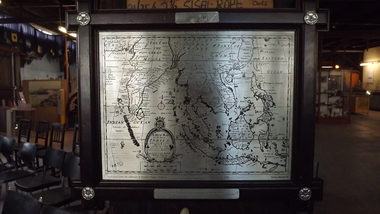
Selangor Pewtor map, Possibly Malaysia
Commemoration of the maiden voyage of the M.V Bunga Kenari.Selangor Pewter Map of East Indies. Original map was created in 1700s and this reproduced pewter map was based upon originals in the Collection of Muzium Negara, Malaysia. The map is framed in a dark wood frame with pewter flowers decorating each corner.On the verso: PMA0299 Text located on map: ‘A NEW MAP OF THE EAST INDIES…’ ‘Reproduced from the collection of Muzium Negara, Malaysia. Selangar Pewter.’ On plaque: ‘IN COMMEMORATION OF THE MAIDEN VOYAGE OF/M.V BUNGA KENARI/MELBOURNE’gifts -
 Montmorency–Eltham RSL Sub Branch
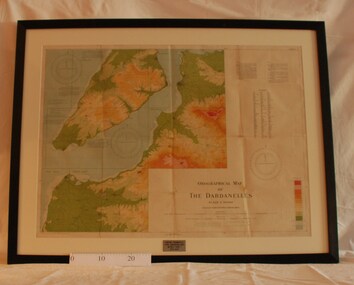
Map - Framed 1915 Map of Krithia, Gallipoli, 1915 Map of Krithia, Gallipolli, 1915
A framed topographical map of The Dardenelles produced from captured Turkish maps by the Egyptian Survey Department. The main feature is the Krithia battlefield area in 1915.Krithia Peninsula (The Dardenelles) World War One - 1915 Mapworld war one, 1915, egypt, map, dardenelles, krithia, survey department, turkey, battlefields -
 Victorian Aboriginal Corporation for Languages
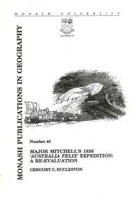
Book, Gregory C Eccleston, Major Mitchell's 1836 "Australia Felix" expedition : a re-evaluation, 1992
Journal style notes with maps and illustrations of the journey of Major Mitchell.maps, b&w illustrations, colour illustrations, tablesthomas mitchell, australia felix, northern victoria, western victoria, local history, exploration -
Victorian Aboriginal Corporation for Languages
Map, Geographic Data Victoria, Vicmap topographic map index as at June 2000, 2000
Index to Vicmap topographic mapping, including 1:25 000 and 1:50 000 topographic maps, and Outdoor leisure series, compiled by the earlier bodies, Survey &? Mapping Victoria, etc. Also indexes Royal Australian Survey Corps' 1:50 000 topographic mapping.mapsvictorian maps, topographic maps -
 Bendigo Military Museum
Memorabilia - TRENCH ART, BRACELET, C.1916
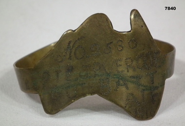
Part of the Cooper Collection. "John Percy VERCOE", No. 2530, enlisted 18/5/16 in 5th Reinforcements, 60 BN. Aged 30 years. Embarked for England 25/9/1916, embarked for France 4/2/1917, WIA 26/4/1918. GSW to left eye, severe. Left eye excised England 30/4/1918. RTA 23/9/1918. Discharged from the AIF 4/1/1919. Passed away 30/12/1925. John received a Congratulatory card from MAJ.General J.H. Hobbs, K.C.B, V.D. Commanding 5th Aust. Division - for bravery and devotion to duty in dressing and carrying wounded to the Regt. Aid Post during a counter attack on Villers Brettoneux on the night of 24/25th April 1918.Brass map of Australia fashioned into a bracelet. Band is secured with a clip. Owners details engraved on the map.Engraved in the face of the map: 'No.2530, PTE J.P. VERCOE, 60TH BATT, AIF, 1916.cooper collection, trench art, john p. vercoe -
 Federation University Historical Collection
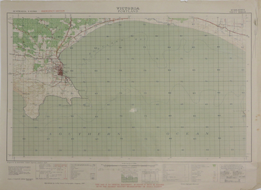
Map, Portland, 1942, 1942
Printed colour map on paper"This map is an official document. If found, it must be handed in to the nearest military headquarters or police. porland, cape nelson, lawrence rock, point danger, whaler's point -
 Wangaratta RSL Sub Branch
Mixed media - Framed Map and Newspaper, Peter Muncey, 23/7/1943
Sketch Map of Bulldog-Wau Road New Guinea drawn to scale by 2/1 Aust Fd Coy dated 23.7.43 and signed by soldiers together with related newspaper article. Hand sketched by Peter Muncey VX10042 a Draughtsman who served in the Middle East Ceylon and New Guinea with the 2/2 and 2/1 Field Coy Royal Australian Engineers. The sketch contains 26 signatures including:- S/Sgt Raymond Hector Ibbotson NX14112 who served in the Middle East and New Guinea Lt Col Jack Graham Wilson NX 130646Bulldog Track also known as Bulldog-Wau road was longer, higher, steeper, wetter, colder and rougher than Kokoda Track. In 1943 Australian Army engineers; the 2/1 and 2/16 Field Company RAE, 9th Australian Field Company (AIF), veterans of Syria, Palestine, Egypt, Greece and Crete, the 1st and 3rd Australian Pack Transport Companies and local Papuan labour cut the road with pickaxes and dynamite over a period of eight months. During five months of operations over seventy per cent of the 2/1 Australian Field Company contracted malaria.Seventeen bridges were constructed; mostly single, but at least one with multiple spans. More than two thousand Australian army personnel and over two thousand Papuans and New Guineans were involved during nine months of construction. Thus the road, acclaimed as the greatest military engineering feat ever, was completed and for the only time in history motor vehicles crossed the high rugged mountains of Papua New Guinea. Carved brown timber frame with cream mount containing hand sketched map with soldiers signatures and two newspaper articles.Sketch Map of Bulldog-Wau Road 23.7.43 2/1 Aust Fd Coy Newspaper - Diggers pushed on with pick and shovelbulldog-wau road, map, new guinea, ww2, 2/1 aust field coy -
 Greensborough Historical Society
Map, John Monash, 1913 Map of Greensborough, 1913
1913 Map of Greensborough, possibly by John Monash. This map shows the area to the north of the township.Map, colour.greensborough - maps, 1913 -
Creswick Campus Historical Collection - University of Melbourne
Maps, 1967 - 1972
Maps of various subjects: Gunbower Island 1972. Barmah Forest 1967. Survey maps from aerial photography 1971 _Narnargoon.Tonimbuk. Gilwell & Beenak.Maps -
 Colac RSL Sub Branch
Work on paper - Baulch Collection, Soldier Settlement Documentation. Lot 21 - Minjah Estate
Historic documentsA4 x3 printed sheets:- - Covering letter from the Soldier Settlement Commission dated 19/10/1955 - Map of Minjah Estate - Map showing the subdivision of Minjah Estate1 x typed letter 2 x copies of mapssoldier settlement allocations -
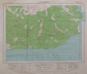 Federation University Historical Collection
Map, Mallacoota, 1942, 1942
Printed colour map on paperThis map is an official document, if found, it must be handed in to the nearest military headquarters or police stationmallacoota, bass straight, cape evarard, cann river, genoa river, disaster bay -
 Kiewa Valley Historical Society
Paper Sheet - Shire of Bright Plans
Oblong sheet of paper - bright yellow (or orange). Black typed writing and subdivision maps of the Kiewa Valley Planning Scheme in the Shire of Bright. Circa 1980s2 pages of maps and scriptshire of bright, maps, kiewa valley -
Glenelg Shire Council Cultural Collection
Postcard - Postcard - Australia Map and Portland, Victoria, n.d
Coloured postcard. Map of Australia, which lifts up to reveal a strip of black and white views of Portland. Each view 4.9 x 3 cm. Representation of two 'cowboys' on horseback, with whips, to the left of map of Australia.Front: 'MAP OF AUSTRALIA FROM PORTLAND' -printed in redportland -
MYLI My Community Library
Map - Nar Nar Goon County of Mornington Map, 1944, H.E Daw - Government Printer, June 1944
This was a map made in the period before Cardinia shire was created in 1994. With intricate labelling of lot allocations, this map is a invaluable research potential for understanding the settlement of the area and its development in the first half of the 1900s. A paper map with yellow shaded areas and black ink.On Left Side: Pakenham (lot numbers throughout the map) Top side: Gembrook, Tonimbuk Right Side: Bunyip, Koo-wee-rup East Bottom Side: By Authority: / H.E. Daw Government Printer / Melbourne Koo-wee-rup Bottom Right Corner: NOTE: The allotments colored brown are freehold. In respect of which the name. The Area, and the Date where given, are the particulars set out in the Crown grant as issued by the Lands Department. / After the issue of the Crown Grant, all subsequent dealings are effected at the office of titles, Queen Street, Melbourne, and particulars as to present registered ownership, boundaries, subdivisions, etc., may be obtained by search at that office. / This plan has been compiled from the Lands Department Record as at June 1944 / Nar-Nar-Goon / County of Mornington / Drawn and reproduced at the department of lands and survey, Melbourne Price 2/. June 1944 h.e. daw, map, nar-nar-goon, county of mornington, pakenham, koo-wee-rup -
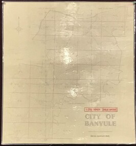 Greensborough Historical Society
Map, Banyule City Council, MMBW, 1:2500 Series. City of Banyule. Master overlay, 1994_
This master overlay is the key to the Melbourne and Metropolitan Board of Works maps: MMBW, 1:2500 Series. The overlay was made by the City of Banyule using the Melways base plan (Edition 23, 1994-95). This overlay can be used to position maps in this series.Laminated map, with overlay of MMBW map grid.mmbw, melbourne and metropolitan board of works, banyule city council -
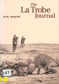 Victorian Aboriginal Corporation for Languages
Periodical, John Barnes, The La Trobe journal, 2001
The main focus of this edition is the extensive map collection of the State Library of Victoria. Contents: From the Editorial Chair Obituary: Estelle Canning Judith Scurfield The Map Section of the State Library Miles Lewis Maps for Building Research Thomas A. Darragh This Beautiful Work of Art?: Skene and Slight's Continental Australia Gerard Hayes Annotation: Ludwig Becker's ?First Camp from Duroadoo? Susan Ballyn Jean Baptiste Lehimas de Arrieta: The First Spanish Settler in Australia? Frances Thiele Recreating the Polite World: Shipboard Life of Nineteenth-Century Lady Travellers to Australia John Barnes Library Profile: Keith Murdochmaps, b&w illustrationsmaps, state library of victoria -
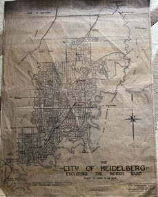 Greensborough Historical Society
Map, City of Heidelberg, City of Heidelberg, - excluding the North Ward, 1959, 27/05/1959
Map of City of Heidelberg showing municipal and ward boundaries; North Ward is excluded from this map.Blue print map"Scale 20 chns to an inch. G.M.H. 27.5.59"city of heidelberg, heidelberg - maps -
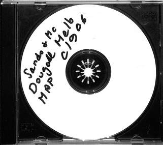 Melbourne Tram Museum
Map - CD - Sands McDougal Map Melbourne c1906, Sands McDougall
Detailed scan of the Sands McDougal Map in colour showing Melbourne's cable trams, railways, Essendon Tramways, NMETL and the Victorian Railways line to Brighton from St Kilda. Includes the MTOCo horse tram lines and the Caulfield horse tram lines. See Reg item 6572 for the actual map. Yields information about Melbourne and its tramways in 1906CD in a plastic case - black with clear cover.CD marked "Sands & McDougal Map c1906"cable trams, tramways, map, sands mcdougal, nmetl, vr trams, horse trams -
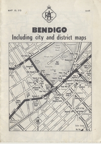 Ballarat Tramway Museum
Map, Royal Automobile Club of Victoria, "Bendigo Including city and district maps - RACV", c1968
Printed street map titled "Bendigo Including city and district maps", published by the RACV, showing the central part of Bendigo on the front cover, Bendigo Outlets and notes on the city itself. Has the tram lines shown dotted, only shows the full extent of the Golden Square line. Inside has a district road map. The front cover has the number "0468" in the bottom left hand corner, indicating the publication date.in ink on the Bendigo Outlet map, has various notes showing the location of crossing loops on and off the map and the location of the tram depot itself.trams, tramways, map, bendigo, racv, railways -
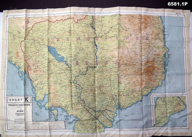 Bendigo Military Museum
Photograph - Photograph of a silk map of Indo China, Circa 1939
Silk maps were produced as "Escape Maps" as they were easily folded and compressed to carry. They were often sewn into the jackets of aircraft pilots..1P Photograph of a Silk map of Indo China Map No 44K covering Siam (Thailand) and part of Vietnam and Cambodia at a scale of 1:1million. The map has contours (heights) and legend panel information. .2P Photograph of the reverse side of a Silk map of Indo China Map No 44J covering Siam (Thailand) at a scale of 1:1million. The map has contours (heights) and legend panel information. royal australian survey corps, rasvy, fortuna, army survey regiment, army svy regt