Showing 147 items
matching on this day in the north east
-
 Federation University Historical Collection
Document - Documents, Australian Government Covid-19 Vaccination Booster Dose information, 19/08/2020
On 12 January, the World Health Organization (WHO) confirmed that a novel coronavirus was the cause of a respiratory illness in a cluster of people in Wuhan City, Hubei Province, China, who had initially come to the attention of the WHO on 31 December 2019. On 3 March, the Reserve Bank of Australia became the first central bank to cut interest rates in response to the outbreak. Official interest rates were cut by 0.25% (25 base points) to a record low of 0.5%. On 12 March, the Federal Government announced a A$17.6 billion stimulus package, the first since the 2008 GFC. he package consists of multiple parts, a one-off A$750 payment to around 6.5 million welfare recipients as early as 31 March 2020, small business assistance with 700,000 grants up to $25,000 and a 50% wage subsidy for 120,000 apprenticies or trainees for up to 9 months, 1 billion to support economically impacted sectors, regions and communities, and $700 million to increase tax write off and $3.2 billion to support short-term small and medium-sized business investment. On 16 March, Premier Dan Andrews and Minister for Health Jenny Mikakos declared a state of emergency for Victoria for at least four weeks. On 19 March, the Reserve Bank again cut interest rates by a further 0.25% to 0.25%, the lowest in Australian history. On 22 March, the government announced a second stimulus package of A$66bn, increasing the amount of total financial package offered to A$89bn. This included several new measures like doubling income support for individuals on Jobseeker's allowance, granting A$100,000 to small and medium-sized businesses and A$715 million to Australian airports and airlines. It also allowed individuals affected by the outbreak to access up to A$10,000 of their superannuation during 2019–2020 and also being able to take an additional same amount for the next year. on the same day Victorian Premier Daniel Andrews announced on 22 March that the state will bring the school holiday forwards to 24 March from 27 March. On 30 March, the Australian Federal Government announced a $130 billion "JobKeeper" wage subsidy program offering to pay employers up to $1500 a fortnight per full-time, part-time or casual employee that has worked for that business for over a year. For a business to be eligible, they must have lost 30% of turnover after 1 March of annual revenue up to and including $1 billion. For businesses with a revenue of over $1 billion, turnover must have decreased by 50%. Businesses are then required by law to pay the subsidy to their staff, in lieu of their usual wages. This response came after the enormous job losses seen just a week prior when an estimated 1 million Australians lost their jobs. This massive loss in jobs caused the myGov website to crash and lines out of Centrelink offices to run hundreds of metres long.The program was backdated to 1 March, to aim at reemploying the many people who had just lost their jobs in the weeks before. Businesses would receive the JobKeeper subsidy for six months. On 2 April, the number of cases in Victoria exceeded 1,000, including over 100 healthcare workers. On 5 April, New South Wales Police launched a criminal investigation into whether the operator of Ruby Princess, Carnival Australia, broke the Biosecurity Act 2015 (Cwth) and New South Wales state laws, by deliberately concealing COVID-19 cases. On 6 April, the Department of Health revealed that 2,432 people recovered from the infection as the federal government started reporting recovery statistics. This is more than a third from the official number reported so far, Deputy Chief Medical Officer Professor Paul Kelly stating, "I think it is important. Firstly it really reinforces that message, which is a true one, that most people who get this disease do recover”. The day before, at 3pm, it was announced that 2,315 of the 5,687 confirmed coronavirus cases had recovered. May 2020 - An outbreak in Victoria at a meatworks that was later revealed to be Cedar Meats was announced on 02 May with eight cases. By 8 May, the cluster of cases linked to Cedar Meats in Victoria was 71, consisting of at least 57 workers and 13 close contacts, including a nurse, aged care worker and high school student. The number had increased to 75 by 9 May, 88 by 13 May, and 90 by 14 May. On 9 May, two Victorian cases were announced to be related to McDonald's Fawkner. By 18 May, this had increased to 12 cases, and on that day it was revealed that a delivery driver had tested positive, prompting the closing for cleaning of 12 more McDonald's locations: Melton East, Laverton North, Yallambie, Taylors Lakes, Campbellfield, Sunbury, Hoppers Crossing, Riverdale Village, Sandown, Calder Highway Northbound/Outbound, Calder Highway Southbound/Inbound, and BP Rockbank Service Centre Outbound. On 15 May, South Australia became the second jurisdiction, after the ACT, to be free of any active cases, however on 26 May, a woman returning from overseas who was granted exemption into South Australia from her hotel quarantine in Victoria tested positive for COVID-19. This was the first new case in 19 days for the state.[101] On 4 June, it was announced that the woman had recovered and the state was free of any active cases once again.[102] On 17 May, Victoria announced two further business sites had been shut down due to a suspected case at each. Domino's Pizza in Fairfield has been shut for two weeks, and mattress manufacturer The Comfort Group in Deer Park was closed from Friday 15 May to at least Wednesday 20 May. On 6 June, both New South Wales and Victoria reported no new cases for the previous 24 hours, with only Queensland and Western Australia reporting one new case each, the lowest national total since February. Western Australia also announced two old cases. However, the new case in Queensland was linked to the Rydges on Swanston cluster in Melbourne when a man who travelled from Melbourne to Brisbane on Virgin flight VA313 on 1 June tested positive.An A4 printed document persented to those who received a Covid19 Vaccination boostercovid-19, corona virus, pandemic, social distancing, lock down, vaccine, vaccine booster -
 Mission to Seafarers Victoria
Print - Reproduction of a painting, Captain James Cook - The First Voyage 1768-1771
The first voyage of Lieutenant James Cook was a combined Royal Navy and Royal Society expedition to the south Pacific Ocean aboard HMS Endeavour, from 1768 to 1771. The aims of this first expedition were to observe the transit of Venus across the Sun (3–4 of June 1769). Departing from Plymouth in August 1768, the expedition crossed the Atlantic, rounded Cape Horn and reached Tahiti in time to observe the transit of Venus. In September 1769 the expedition reached New Zealand. In April 1770 they became the first known Europeans to reach the east coast of Australia, making landfall near present-day Point Hicks, and then proceeding north to Botany Bay. The expedition continued northward along the Australian coastline. In October 1770 they reached the port of Batavia in the Dutch East Indies. They resumed their journey on 26 December, rounded the Cape of Good Hope on 13 March 1771, and reached the English port of Deal on 12 July. The voyage lasted almost three years. Voyage 1 (1768–1771): ship Endeavour Route: London – Madiera – Rio de Janeiro – Cape Horn – Tuamotu Island – Tahiti – Society Islands – New Zealand – New Holland (Australia) – East Timor – Java – Batavia – Cape of Good Hope – St Helena – Ascension – LondonCook joined the British merchant navy as a teenager and joined the Royal Navy in 1755.Colour reproduction of portrait of Captain Cook by Nathaniel Dance (1735-1811)Captain James Cook - The First Voyage 1768-1771captain james cook, nathaniel dance (1735-1811), endeavour, navigators, sea voyage -
 Kiewa Valley Historical Society
Meter Ammeter Recorder, Circa 1950
This testing voltmeter recorder was last certified by SEC Vic laboratories on the 17/4/77. It was used extensively as mobile recorder placed for periods of one month at locations experiencing unacceptable fluctuations of power. These locations would cover the North East regions of Victoria. They cover voltage drops at domestic and business properties especially those that were experiencing regular fluctuations(daily) at approximately the same time of the day. As the electrical network is required to operate within a set level of voltage, fluctuations outside of this has to be investigated and necessary remedial action taken. This is especially so for rural properties where power "drainage" can occur through animal/bird and tree interference. It can also be the result of defective wiring and overloading at peek operational times (milking machines).This mobile voltage recorder is very significant to the Kiewa Valley because it highlights the difficulties that can occur in maintaining a power supply that experiences fluctuating power demands by the rural industries that it supplies. The requirement of a mobile testing apparatus to cover the various sections in the Kiewa Valley and other rural areas in the northeast region is one of necessity as electricity once connected to a rural property is a labour saving supply as generators on rural properties require a higher degree of maintenance an ultimately at a higher cost. The testing of the SEC Vic supplied electricity to rural properties,those who had previously run on generators, had to be quick and unassuming with certainty of correct supply levels.The mechanism of this voltage recorder has been installed(by the manufacturer) into its own protective wooden box. This box has a front (swing open) lockable section which permits direct access to the installed measuring equipment (for servicing and data collection). The top section of the box has two screw on terminals for access to the machine being tested. This tester has its own inbuilt ink supply facilities and a mechanical clockwork device that unwinds a roll of paper onto a second roll at a rate of 10 mm per hour. The recording chart is marked with time slots against voltage. There is a recording arm which has an ink pen at the end. Both arm and pen carry the ink supply from the ink reservoir, located on the left side of the cabinet door in specially constructed bottle holder( three small bottle capacity). To record a suspect power problem to a home or business establishment the voltmeter is connected to a power supply outlet being tested and wind the recording clockwork mechanism (gives a four week running time). Before leaving the recorder in situ the electrician checks to see if the chart is recording the correct voltage and that the clock mechanism is advancing correctly.On the front of the access "door" at the top a metal label "RECORDING AMMETER" below this "MURDAY SYSTEM" below this "ALTERNATING CURRENT" and below this the manufacturer's registered number "No. 139156" Below this is a metal tag with State Electricity Commission of Victoria Electrical Engineer's Section equipment number "338" Below these tags and above the viewing window is the manufacturer's dtails "EVERSHED & VIGNOLES Led LONDON"sec vic kiewa hydro scheme, alternate energy supplies, alpine feasibility studies temperature, rainfall, power outages -
 Kiewa Valley Historical Society
Case Volt Meter Recorder, Circa 1950 to 1977
This case is for a testing voltmeter recorder. The last time it was certified by SEC Vic laboratories on the 17/4/77. It was used extensively in the transportation of the mobile recorder which was sometimes placed for periods of one month at locations experiencing unacceptable fluctuations of power. These locations would cover the North East regions of Victoria. They cover voltage drops at domestic and business properties especially those that were experiencing regular fluctuations(daily) at approximately the same time of the day. As the electrical network is required to operate within a set level of voltage, fluctuations outside of this has to be investigated and necessary remedial action taken. This is especially so for rural properties where power "drainage" can occur through animal/bird and tree interference. See KVHS 0302 (A) for the instrument.This case for a mobile voltage recorder is very significant to the Kiewa Valley because it highlights the difficulties that can occur in maintaining a power supply that experiences fluctuating power demands by the rural industries that it supplies. The requirement of a mobile testing apparatus to cover the various sections in the Kiewa Valley and other rural areas in the northeast region is one of necessity as electricity once connected to a rural property is a labour saving supply as generators on rural properties require a higher degree of maintenance an ultimately at a higher cost. The testing of the SEC Vic supplied electricity to rural properties,those who had previously run on generators, had to be quick and unassuming with certainty of correct supply levels.This heavy and thick all leather case for the "easy" transportation of the Volt meter recorder has a opening top which pop riveted to the main body(rivets are aluminium). The all leather top has a shaped carrying handle which is also riveted on. There are two straps on the side of the top which can be fastened to the main body by metal "shoe" buckles. The bottom end is secured to the main bag by large rivets.Tick grade stitching is on all corners.Nilsec vic kiewa hydro scheme, alternate energy supplies, alpine growth in electricity consumption -
 Eltham District Historical Society Inc
Magazine, Sun News-Pictorial, Bush Fires: A pictorial survey of Victoria's most tragic week, January 8-15, 1939, 1939
THE WEEK REVIEWED (Article; Bush Fires: A pictorial survey of Victoria's most tragic week, January 8-15, 1939. Published in aid of the Bush Fire Relief Fund by the Sun News-Pictorial in co-operation with its newsagents, pp2-3) THE fiercest bush fires Australia has known since its discovery are quiescent at the moment, and Victoria, in the comparative coolness of the change which came with rain on Sunday night, has begun·to count its losses. In the fiery eight days, from Sunday to Sunday, at least sixty-six men, women and children have lost their lives in forest fires, or have succumbed to burns and shock; many others have died from heat; and several serious cases of burns are being treated in hospitals. Two babies in Narrandera district have died, and ten others are in hospital, because of milk soured by the record temperatures of those eight days. Forest damage totals at least a million pounds, and incalculable damage has been done to the seedlings which were to have been the forests of the future. Water conservation will be seriously affected by the silting-up of reservoirs and streams from which protective timber has been taken by the all-engulfing flames. More than a thousand houses have been destroyed, and these, with 40 mills, and schools, post-offices, churches, and other buildings, represent a loss of at least half a million. At least 1500 are homeless. For their aid, money raised in appeals has now passed the £50,000 mark, and the biggest relief organisation ever set up in peace time has swung into operation. The First Hint Victoria's first hint of what was to come appeared on Sunday, January 8, when most parts of the State awoke to find a blistering day awaiting. At 12.20 p.m., when the thermometer reached its highest for the day, 109.6 degrees, the first fire victims were at that moment going to their death on a bush track five feet wide off the main road to Narbethong. They were the forestry officers Charles Isaac Demby and John Hartley Barling, who went to warn Demby of his danger when he parted from his companions, and was himself surrounded by the treacherous fire. It was not until 8 o'clock next morning that the tragic news was flashed throughout the State. Searchers found the two charred bodies close together, one seeking protection in the nook of two logs. Barling's watch had stopped at 1.20. In the meantime, tragedy was spreading its cloak. By Monday, big fires were raging at Toolangi, Erica, Yallourn, Monbulk, Frankston, Dromana, Drouin South, Glenburn, and Blackwood, with smaller outbreaks at many other centres. In the ensuing week, while women and children were evacuated as fast as the flames would permit, Erica-scene of the 1926 fire disaster-thrice escaped doom by a change of wind. Indeed, those who have been in the fire country these past days say that the numbers of times a change of wind has saved towns from destruction is amazing. In the towns they speak of miracles. Monday's Miracles The escapes from Monett's Mill at Erica and from the Hardwood Company's Mill at Murrindindi, near where Demby and Barling went to their death, were Monday's miracles. Twenty came out alive from each mill. At the first a 60ft. dugout provided an oven-like refuge; at the second, 12 women and children survived in the smoke-filled gloom of a three-roomed cottage while their eight men, their clothes sometimes afire, poured water on the wooden walls. Three houses out of ten remained when the fire had passed. Record Temperatures Sunday had been the hottest Melbourne day for 33 years; Monday dropped to a 76.1 degree maximum; but Tuesday dawned hotter than ever, the mercury reaching 112.5. By now rumor was racing ahead of fact; whole towns were being reported lost; the alarm was raised for scores of missing persons. But fact soon overtook rumor, and within a few days the staggering toll began to mount to a figure beyond the wildest imaginings of the panic-stricken. Six died from heat on this torrid Tuesday, and the fires spread in a wide swathe from south-west to north-east across the State. Fish died in shallow streams. A curtain of smoke hid the sky from all Victoria, and hung far out to sea. It alarmed passengers on ships. On the Ormonde, on the voyage to Sydney from Burnie, women ran on deck, believing fire had broken out in the hold. Days later the smoke reached New Zealand. In Melbourne thousands of fire-volunteers were leaving in cars: vans, motor-buses-anything reliable on wheels-to aid the country in its grim fight. In the fires at Rubicon and. Narbethong, seventeen were facing death this day. But not till Wednesday, when Melbourne breathed again in a cool change, while the country still sweltered in temperatures up to 117 degrees, did the news come through the tree blocked roads. A woman and her little daughter, trapped on the road, were among those who died. Their bodies, and those of menfolk with them, were found strewn out at intervals along the road, where the furnace of the surrounding fire had dropped them in their tracks as they ran. Twelve died at a Rubicon mill, five on the road at Narbethong. At Alexandra, not far distant, a baby was born while the fires raged, and stretcher-bearers brought in the injured. On Thursday the State Government voted £5000 for the relief of fire victims. The Governor (Lord Huntingfield) and the Lord Mayor (Cr. Coles) visited some of the stricken areas, and dipped into their pockets personally. Later, the City Council, too, voted £5000. Friday, The 13th Friday, the Thirteenth, justified its evil name. A blistering northerly came early in the morning, presaging destruction, and forcing the mercury to a new record of 114 degrees. Racing fires killed at least ten in those terrible 12 hours. Four children were engulfed in the furnace at Colac. Panic drove them, uncontrollable, into the smoke-filled road when the fire raced down behind their home. They choked to death. In other parts fires were joining to make fronts of scores of miles. Kinglake was being menaced on two fronts, £60,000 worth of timber was going up in smoke in Ballarat district. Warburton was surrounded. Residents at Lorne, favoured resort, were being driven to the sea-front by a fire which destroyed at least 20 homes. Healewille. with flames visible from the town at one stage, was in a trough between two fires which burned four guest-houses, seven homes and left its surrounding beauty-spots wastes of bowed-over, blackened tree-fern fronds; with its famous Sanctuary, however, intact. Most of Omeo was destroyed this black day: Noojee. while 200 residents crouched in the river, was being reduced to a waste of buckled iron and smoking timber; Erica was once again saved by a change of wind. Beneath a pall of smoke, the Rubicon victims were buried at Alexandra. Friday night and the early hours of Saturday saw the streets of beleagured towns strewn with exhausted fire-fighters. Their flails beside them, ready for the next call, they lay where exhaustion overtook them-on footpaths, beside lamp-posts, in gutters, in cars, under trucks. Saturday's dawn brought clear skies and lower temperatures in many parts, and from the burnt-out areas came a great rush of tragic reports. The death-roll rushed past the fifty mark with incredible speed. Some had been trapped on roads, others at mills; some, after burying their treasures, had clung too long to the places they had made their homes for many years. Four men lost their lives because one went back for his dog. By Sunday, when the first of the saving rain came, nearly another score of names had been added to the list.Newspaper magazine, 48 pages (incl. covers). Fully digitised and searchable PDFPublished in aid of the Bush Fire Relief Fund by the Sun News-Pictorial in co-operation with its newsagents.bushfires, 1939 bushfires, black friday, warrandyte -
 Ringwood and District Historical Society
Photograph - Newspaper Clipping, Early View of Club Hotel, Ringwood East
The newspaper clipping caption is incorrect. The Club Hotel featured in the article was located on the north side of Mount Dandenong Road. It was destroyed by fire in 1890 prior to re-opening later on the south side where it operated until sale and demolition in 2020 to make way for a retirement village. (See PDF attached - "SS0067 Vic Collections 3754b - Club Hotel Fire 1890").Early View of Club Hotel, Ringwood East. Weatherboard with iron roof. Single chimney on one end. Picket fence on RHS. Two horse-drawn vehicles standing out front including three adults and two children. Source/date of newspaper unknown. Later newspaper item also attached reporting hotel being destroyed by fire in 1890.Caption: There was 'antimony in them thar hills' at Ringwood when this picture was taken in the 1890s. At that time the Club Hotel in Mt Dandenong Road, East Ringwood was owned by a George Wiggin. There were antimony mines operating nearby. The present-day Club Hotel is on this site. -
 Ringwood and District Historical Society
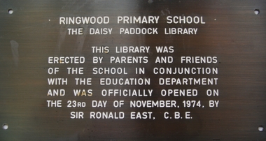
Plaque, Ringwood Primary School plaque commemorating the Daisy Paddock Library - 1974, 1974
Installed 1974. This Ringwood Primary School ceased operation c.1985. Daisy Paddock was the infant mistress at the school, and lived in Thanet Street, Ringwood.Bronze plaque, engraved, with white paint infill: 'Ringwood Primary School/ The Daisy Paddock Library'. +Additional Keywords: Paddock, DaisyRingwood Primary School/ The Daisy Paddock Library/ This library was/ erected by parents and friends/ of the school in conjunction/ with the Education Department/ and was officially opened on/ the 23rd day of November, 1974. by/ Sir Ronald East, C.B.E. -
 Ringwood and District Historical Society
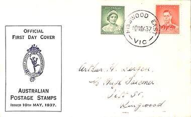
Memorabilia - Postage envelope, Official First Day Cover 1d and 2d stamps postmarked Ringwood East Victoria 10th May 1937, 10-May-37
Envelope with 1d and 2d stamps postmarked Ringwood East Victoria 10th May 1937 addressed to Arthur H Bergen, C/- Hugh Falconer, Pitt Street, Ringwood. -
 Eltham District Historical Society Inc
Photograph, Margaret Ball, Jock Read outside home, 54 Henry Street, Eltham, c.Anzac Day 2000, 25 Apr 2000
The adjoining block at no. 52 was not developed at the time. Since Feb 2014 (most recent Google Street View as of Jan 2018), both sites have been bulldozed and new developments built.The Margaret Ball (Pre 1960s Houses) Collection was a personal project initiated to mark the year 2000 and arose as a result of the disappearance of many pre-1960s parts of Eltham due to development. Approximately 200 pre-1960s style houses that were left in Eltham between Main Road and east to Bible Street, between Cecil Street to the north and south to Dalton Street were photographed in late 1999. Not all of the houses could be photographed; some because the garden or trees blocked the view of the house, others because of rubbish or cars were in the way, some because people were working on the house or in the gardens at the time.Colour photographic printeltham, houses, streets, margaret ball (pre 1960s houses) collection, henry street, jock read, lofty (horse) -
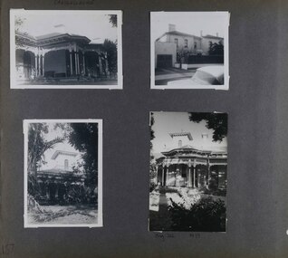
 Glen Eira Historical Society
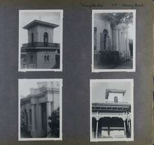
Album - Album page, Craigellachie, 273 Orrong Road, Circa 1972
This photograph is part of the Caulfield Historical Album 1972. This album was created in approximately 1972 as part of a project by the Caulfield Historical Society to assist in identifying buildings worthy of preservation. The album is related to a Survey the Caulfield Historical Society developed in collaboration with the National Trust of Australia (Victoria) and Caulfield City Council to identify historic buildings within the City of Caulfield that warranted the protection of a National Trust Classification. Principal photographer thought to be Trevor Hart, member of Caulfield Historical Society. Most photographs were taken between 1966-1972 with a small number of photographs being older and from unknown sources. All photographs are black and white except where stated, with 386 photographs over 198 pages. From Victorian Heritage Database citation HO40 Craigellachie 2b & 2c Lynedoch Avenue Caulfield North https://vhd.heritagecouncil.vic.gov.au/places/35209 as at (28/10/2020) Craigellachie" is situated at No. 2B Lynedoch Avenue, Caulfield North, and was built for the noted investor, pastoralist and politician, William Pearson, not earlier than 1864 and possible in 1876, undergoing several substantial and contributory extensions during the nineteenth century. It is historically and aesthetically significant. From Victorian Heritage Database citation for HO40 Craigellachie https://vhd.heritagecouncil.vic.gov.au/places/35209 as at (28/10/2020) It is historically significant (Criterion A) as the Melbourne home of William Pearson, MLA, MLC and principal shareholder in Walhalla's Long Tunnel Extended Gold Mining Co. which sustained the township well past the turn of the twentieth century and occupied fifth place amongst Victoria's richest mines. It is aesthetically significant (Criterion E) for its capacity to demonstrate Pearson's continuing financial success throughout the mid to late nineteenth century, the additions associated with the tower being most noteworthy as an example of the lasting appeal of the Italian Style, popularized in the pattern books of the day. The Ailanthus altissima (Tree of Heaven) is significant as an outstanding example of a species that is rare in cultivation, as well as for its very high aesthetic value. The Araucaria bidwilli is notable as a fine example of a species infrequently planted in Melbourne and rarely found in private suburban gardens.Page 156 of Photograph Album with four landscape photographs of Craigellachie - near views of architectural features. Handwritten: "Craigellachie" 273 Orrong Road [top right] / 156 [bottom right]trevor hart, verandah, orrong road, tower, curved windows, decorative brackets, italianate, mansion, 1870's, william pearson, inkerman street, apartments, spire, decorative plaster work, rendered walls, ornamentation, arched windows, moulded ornaments, 1860's, lynedoch avenue, classical style, caulfield north, craigellachie, cast iron work, victorian style, balaclava, st kilda east, gardens, ailanthus altissima, araucaria bidwilli, porches, trees -
 Glen Eira Historical Society
Album - Album page, Craigellachie, 273 Orrong Road, Circa 1972
This photograph is part of the Caulfield Historical Album 1972. This album was created in approximately 1972 as part of a project by the Caulfield Historical Society to assist in identifying buildings worthy of preservation. The album is related to a Survey the Caulfield Historical Society developed in collaboration with the National Trust of Australia (Victoria) and Caulfield City Council to identify historic buildings within the City of Caulfield that warranted the protection of a National Trust Classification. Principal photographer thought to be Trevor Hart, member of Caulfield Historical Society. Most photographs were taken between 1966-1972 with a small number of photographs being older and from unknown sources. All photographs are black and white except where stated, with 386 photographs over 198 pages. From Victorian Heritage Database citation for HO40 Craigellachie 2b & 2c Lynedoch Avenue Caulfield North https://vhd.heritagecouncil.vic.gov.au/places/35209 as at (28/10/2020) Craigellachie" is situated at No. 2B Lynedoch Avenue, Caulfield North, and was built for the noted investor, pastoralist and politician, William Pearson, not earlier than 1864 and possible in 1876, undergoing several substantial and contributory extensions during the nineteenth century. It is historically and aesthetically significant. From Victorian Heritage Database citation for HO40 Craigellachie https://vhd.heritagecouncil.vic.gov.au/places/35209 as at (28/10/2020) It is historically significant (Criterion A) as the Melbourne home of William Pearson, MLA, MLC and principal shareholder in Walhalla's Long Tunnel Extended Gold Mining Co. which sustained the township well past the turn of the twentieth century and occupied fifth place amongst Victoria's richest mines. It is aesthetically significant (Criterion E) for its capacity to demonstrate Pearson's continuing financial success throughout the mid to late nineteenth century, the additions associated with the tower being most noteworthy as an example of the lasting appeal of the Italian Style, popularized in the pattern books of the day. The Ailanthus altissima (Tree of Heaven) is significant as an outstanding example of a species that is rare in cultivation, as well as for its very high aesthetic value. The Araucaria bidwilli is notable as a fine example of a species infrequently planted in Melbourne and rarely found in private suburban gardens.Page 157 - four photographs of Craigellachie - exterior views. Handwritten: CRAIGELLACHIE [top left] / Neg 212 1973 [under bottom right photo] / 157 [bottom left]trevor hart, verandah, orrong road, tower, cast iron lacework, curved windows, decorative brackets, italianate, mansion, 1870's, william pearson, inkerman street, apartments, spire, decorative plaster work, rendered walls, arched windows, moulded ornaments, 1860's, lynedoch avenue, classical style, caulfield north, craigellachie, st kilda east, late victorian style, garages (private), gardens, cast iron work, ailanthus altissima, araucaria bidwilli, trees -
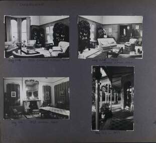 Glen Eira Historical Society
Album - Album page, Craigellachie, 273 Orrong Road, Circa 1972
This photograph is part of the Caulfield Historical Album 1972. This album was created in approximately 1972 as part of a project by the Caulfield Historical Society to assist in identifying buildings worthy of preservation. The album is related to a Survey the Caulfield Historical Society developed in collaboration with the National Trust of Australia (Victoria) and Caulfield City Council to identify historic buildings within the City of Caulfield that warranted the protection of a National Trust Classification. Principal photographer thought to be Trevor Hart, member of Caulfield Historical Society. Most photographs were taken between 1966-1972 with a small number of photographs being older and from unknown sources. All photographs are black and white except where stated, with 386 photographs over 198 pages. From Victorian Heritage Database citation for HO40 Craigellachie 2b & 2c Lynedoch Avenue Caulfield North https://vhd.heritagecouncil.vic.gov.au/places/35209 as at (28/10/2020) Craigellachie" is situated at No. 2B Lynedoch Avenue, Caulfield North, and was built for the noted investor, pastoralist and politician, William Pearson, not earlier than 1864 and possible in 1876, undergoing several substantial and contributory extensions during the nineteenth century. It is historically and aesthetically significant. From Victorian Heritage Database citation for HO40 Craigellachie https://vhd.heritagecouncil.vic.gov.au/places/35209 as at (28/10/2020) It is historically significant (Criterion A) as the Melbourne home of William Pearson, MLA, MLC and principal shareholder in Walhalla's Long Tunnel Extended Gold Mining Co. which sustained the township well past the turn of the twentieth century and occupied fifth place amongst Victoria's richest mines. It is aesthetically significant (Criterion E) for its capacity to demonstrate Pearson's continuing financial success throughout the mid to late nineteenth century, the additions associated with the tower being most noteworthy as an example of the lasting appeal of the Italian Style, popularized in the pattern books of the day. The Ailanthus altissima (Tree of Heaven) is significant as an outstanding example of a species that is rare in cultivation, as well as for its very high aesthetic value. The Araucaria bidwilli is notable as a fine example of a species infrequently planted in Melbourne and rarely found in private suburban gardens.Page 159 - four photographs of Craigellachie - three room interiors and along the verandah. Handwritten: CRAIGELLACHIE [top left] / Neg 224 1973 CHINESE SITTING ROOM [under top right photo] / Neg 226 1973 / CHINESE SITTING ROOM [under top right photo] / Neg 214 1973 DINING ROOM [under bottom left photo] / Neg 213 - 1973 [under bottom right photo] / 159 [bottom left]trevor hart, verandah, orrong road, tower, curved windows, decorative brackets, craigellache, italianate, mansion, 1870's, william pearson, inkerman street, apartments, spire, decorative plaster work, rendered walls, arched windows, moulded ornaments, 1860's, lynedoch avenue, classical style, caulfield north, craigellachie, land subdivision, gardens, late victorian style, cast iron work, st kilda east, dining rooms, sitting rooms, furnishings, tiles -
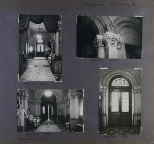 Glen Eira Historical Society
Album - Album page, Craigellachie, 273 Orrong Road, Circa 1972
This photograph is part of the Caulfield Historical Album 1972. This album was created in approximately 1972 as part of a project by the Caulfield Historical Society to assist in identifying buildings worthy of preservation. The album is related to a Survey the Caulfield Historical Society developed in collaboration with the National Trust of Australia (Victoria) and Caulfield City Council to identify historic buildings within the City of Caulfield that warranted the protection of a National Trust Classification. Principal photographer thought to be Trevor Hart, member of Caulfield Historical Society. Most photographs were taken between 1966-1972 with a small number of photographs being older and from unknown sources. All photographs are black and white except where stated, with 386 photographs over 198 pages. From Victorian Heritage Database citation for HO40 Craigellachie 2b & 2c Lynedoch Avenue Caulfield North https://vhd.heritagecouncil.vic.gov.au/places/35209 as at (28/10/2020) Craigellachie" is situated at No. 2B Lynedoch Avenue, Caulfield North, and was built for the noted investor, pastoralist and politician, William Pearson, not earlier than 1864 and possible in 1876, undergoing several substantial and contributory extensions during the nineteenth century. It is historically and aesthetically significant.From Victorian Heritage Database citation for HO40 Craigellachie https://vhd.heritagecouncil.vic.gov.au/places/35209 as at (28/10/2020) It is historically significant (Criterion A) as the Melbourne home of William Pearson, MLA, MLC and principal shareholder in Walhalla's Long Tunnel Extended Gold Mining Co. which sustained the township well past the turn of the twentieth century and occupied fifth place amongst Victoria's richest mines. It is aesthetically significant (Criterion E) for its capacity to demonstrate Pearson's continuing financial success throughout the mid to late nineteenth century, the additions associated with the tower being most noteworthy as an example of the lasting appeal of the Italian Style, popularized in the pattern books of the day. The Ailanthus altissima (Tree of Heaven) is significant as an outstanding example of a species that is rare in cultivation, as well as for its very high aesthetic value. The Araucaria bidwilli is notable as a fine example of a species infrequently planted in Melbourne and rarely found in private suburban gardens.Page 160 - four photographs of Craigellachie interiors. Handwritten: "Craigellachie" 273 Orrong Road [top right] / 156 [bottom right]trevor hart, orrong road, italianate, mansion, 1870's, william pearson, inkerman street, decorative plaster work, rendered walls, ornamentation, moulded ornaments, 1860's, lynedoch avenue, classical style, caulfield north, craigellachie, late victorian style, st kilda east, hallways, arched doors, stained glass, mrs francis, furnishings -
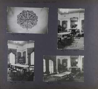 Glen Eira Historical Society
Album - Album page, Craigellachie, 273 Orrong Road, Circa 1972
This photograph is part of the Caulfield Historical Album 1972. This album was created in approximately 1972 as part of a project by the Caulfield Historical Society to assist in identifying buildings worthy of preservation. The album is related to a Survey the Caulfield Historical Society developed in collaboration with the National Trust of Australia (Victoria) and Caulfield City Council to identify historic buildings within the City of Caulfield that warranted the protection of a National Trust Classification. Principal photographer thought to be Trevor Hart, member of Caulfield Historical Society. Most photographs were taken between 1966-1972 with a small number of photographs being older and from unknown sources. All photographs are black and white except where stated, with 386 photographs over 198 pages. From Victorian Heritage Database citation for HO40 Craigellachie 2b & 2c Lynedoch Avenue Caulfield North https://vhd.heritagecouncil.vic.gov.au/places/35209 as at (28/10/2020) Craigellachie" is situated at No. 2B Lynedoch Avenue, Caulfield North, and was built for the noted investor, pastoralist and politician, William Pearson, not earlier than 1864 and possible in 1876, undergoing several substantial and contributory extensions during the nineteenth century. It is historically and aesthetically significant. From Victorian Heritage Database citation for HO40 Craigellachie https://vhd.heritagecouncil.vic.gov.au/places/35209 as at (28/10/2020) It is historically significant (Criterion A) as the Melbourne home of William Pearson, MLA, MLC and principal shareholder in Walhalla's Long Tunnel Extended Gold Mining Co. which sustained the township well past the turn of the twentieth century and occupied fifth place amongst Victoria's richest mines. It is aesthetically significant (Criterion E) for its capacity to demonstrate Pearson's continuing financial success throughout the mid to late nineteenth century, the additions associated with the tower being most noteworthy as an example of the lasting appeal of the Italian Style, popularized in the pattern books of the day. The Ailanthus altissima (Tree of Heaven) is significant as an outstanding example of a species that is rare in cultivation, as well as for its very high aesthetic value. The Araucaria bidwilli is notable as a fine example of a species infrequently planted in Melbourne and rarely found in private suburban gardens.Page 161 - four photographs of Craigellachie dining room Handwritten: CRAIGELLACHIE DINING ROOM [top left] / Neg 218 1973 [under top left photo] / Neg 217 - 1973 [under top right photo] / Neg 216- 1973 [under bottom left photo] / Neg 215 1973 [under bottom right photo] / 161 [bottom left]trevor hart, orrong road, curved windows, italianate, mansion, 1870's, william pearson, inkerman street, decorative plaster work, rendered walls, moulded ornaments, 1860's, lynedoch avenue, classical style, caulfield north, craigellachie, land subdivision, late victorian style, dining rooms, ceiling roses, furnishings, fireplaces, st kilda east -
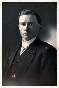 Federation University Historical Collection
Photograph - Black and White, Chatham-Holmes Collection: Lance Corporal Horace Pickford, c1914
Horace Pickford was born at Clunes, Victoria. Private Horace Pickford (2882) enlisted for service during [[World War One]] at Melbourne. on 18 June 1915. He gave his mother, Bessie Pickford of Yeovil Estate Clunes, as his next of kin. He served with the 57th Battalion until he was transferred to the 58th Battalion on 15 March 1916. He was appointed Lance Corporal on 01 December 1916, and was wounded in the back in France the next day and evacuated to England from Rouen. On 03 March 1917 Pickford was awarded the D.C.M. for conspicuous gallantry in action, and rejoined his unit in France on 09 July 1917. On 24 August 1917 Horace Pickford was promted to Corporal. He was killed in Action in France on 27 September 1917 and buried in the vicinity of Polygone Wood. The grave was later docuemnted at being located in the Tyne Cot. Military Cemetery (Plot 62, Row E. Grave2). This cemetery is in Passchendaele, 5 1'2 miles north east of Ypres. Horace Pickford married after enlistment, and his wife Mrs Sarah Ida Isabel (Ida) Pickford of 261 Malvern Road South Yarra became his next of kin. Postcard - black and white portrait of Horace Pickford. Written on back: "Lance Corporal Horace Pickford 2882 C Company 58th Battalion Aust Imp Forces On Active Service Abroad"pickford, chatham-holmes collection, horace pickford, australian imperial forces, c company, active service, pickford collection, world war one, yeovil -
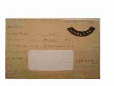 Red Cliffs Military Museum
Certificate, Certificate of Interrogation Questionniares, 14/5/1945 (exact)
There is some information hidden by the hand written information on a card in the middle of the certificate.A small card sized certificate belonging to A.J. Roddy with type written fields completed in ink by the interrogating officer. There is type written information outlining the requirements for the card holder. Card was produced by M19 and interrogation by Intelligence Officer 14 May 1945.Top of Card Type Written in Capitals: CERTIFICATE IN RESPECT OF COMPLETION OF MI9 INTERROGATION QUESTIONNAIRE./Left hand side: CERTIFIED THAT/ NUMBER (in ink) VX8007 RANK (ink) DVR./Name & Initials in BLOCKS (ink) RODDY AJ/Unit (ink) AMN Coy AASC 6 Australian Div/ has completed MI9/ Date (ink) 14 May (Typed) 45/ The Centre of the card is covered with a hand written note that states:- On arrival in England/ spent the first whole/ day in interrogation/ many Nazis were picked up by this method./ A.I.S. (I.S.9), ink Signature L.E. Friend Capt/C.M.F. Intelligence Officer./ Note. This Certifivate MUST be carefully retained by the individual with whom/ it refers and MUST be/ produced to the appropriate authorities on request,/ whether in the Middle East, North Africa or the United Kingdom.officer, certificate, interrogation, questionnaire, certified, intelligence -
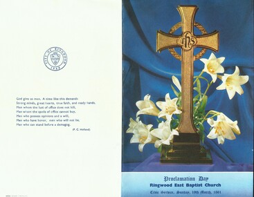 Ringwood and District Historical Society
Photograph, Service on 19th March 1961 at Ringwood East Bapist Church to celebrate the anniversary of Proclamation Day for Ringwood City Council
Service on 19th March 1961 at Ringwood East Bapist Church to celebrate the anniversary of Proclamation Day for Ringwood City Council. Mayor RC Horman in attendance. All material is from Gwen Horman’s three albums that she owned. -
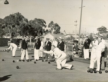 Ringwood and District Historical Society
Photograph, Ringwood Bowls Club - Opening day in the 1953-54 season at the Miles Avenue green, looking East, showing bowlers competing on the green
Black and white photograph"Written on back of photograph" Opening Day, 1953-54. -
 Bendigo Historical Society Inc.
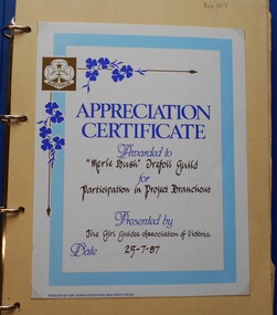
Album - Merle Bush Trefoil Guild: Photographs
The Merle Bush Trefoil Guild was registered in Bendigo on 18/06/1981.The decision to disband the Merle Bush Trefoil Guild was made at a General Meeting on 17/02/2016. The group agreed to continue as the Merle Bush Friendship Group. The Australian Trefoil Guilds connect women who are either actively involved in Girl Guiding or have a history with Girl Guiding. The purpose of a Trefoil Guild is to keep alive the spirit of the Promise and Law, carry this spirit into the community and to give support Guiding.Blue vinyl covered four ring binder containing photographs of activities of the Merle Bush Trefoil Guild. The photographs are mounted (glued) on to buff coloured card from manilla folders cut in half. 61 pp with hand written numbers in top RH corner. Pages 25 and 26 Missing. The first page has an "Appreciation Certificate Awarded to the Merle Bush Trefoil Guild for Participation in Project Branchout. Presented by The Girl Guides association of Victoria. Date 25-7-87. The pages have handwritten annotations of names of people in the photographs. Includes Region Conference East Loddon 25/08/89, 7th National Gathering Stawell Tops 1985, 8th National gathering Monash university 1988 Tour of Government House Day 16th December 1989 Brittania Park labour Day Weekend 1990 A.G.M. 5th May 1990 Region Reunion Day Cohuna 19th August 1990 RR Day North Central Region 10th A.G.M. 4th May 1991 Reaffirmation of Promise 2/7/91 Gwen Derby and Fay Osborn The Chalet, Brittania Park, March Long weekend 1992 24 Hour Gathering Bendigo 15/16 October 1997 Benalla Rose Gardens 16 May 2001 Social BBQ Christmas 2001 Melbourne Cup day 1999 24 Hour Gathering Oct 1999 24 Hour Gathering Stawell 2001 24 Hour Gathering Phillip Island 2003 25th Anniversary 2006 Long Service Awards 15 Oct 2006 100 years of Guiding Christmas 2011girl guides, guiding, merle bush, trefoil guild -
National Vietnam Veterans Museum (NVVM)
Poster - Poster, Information Board, 5 RAR 1966 - 1967 (1st Tour)
An Poster, Information Board of 5 RAR 1966 to 1967 (tst Tour). The 5th Battalion Royal Australian Regiment ("Battalion") were the leading element of the First Australian Task Force (1 ATF) and stationed in Vietnam from 1966 to 1967. The Battalion's task was to break Viet Cong control over the central region of Phuoc Tuy Province - an area that communists had freely operated in since 1945. Commencing of the 24th May 1966, the Battalion conducted its first operation codenamed "Hardihood". Their objective was to sweep and clear areas to the north and east of Nui Dat to a distance of 5000 meters, then create a defensive position to enable 1 ATF to establish an operation base. The Battalion conducted eighteen full-lenght operations as well as numerous day and night cordon and search, search and destroy, ambush and clearing patrols conducted at company, platoon and section levels. the Battalion achieved considerable success during Operations Canberra and Queanbeyan in October 1966 when it swept and cleared the Nui Thi Vai mountain. A Viet Cong base consisting of training facilities, a hospital, booby trap factory and several tonnes of rice was located and destroyed. during phase two (Operation Queanbeyan) the battalion discovered complex cave and tunnel systems along with other fixed installations that were vigorously fought for and destroyed by the battalion. Not only di the caves contain large quantities of weapons, equipment and documents but the 274 VC Regiments deputy commanders radio complex. For bravery and leadership, three Military Crosses, one Military Medal and one Mentioned in Dispatches were awarded. The last was awarded posthumously. However, at the completion of the battalion's first tour, the 274 and 275 Viet Cong Regiments remained functional. While the enemy retained the capacity to inflict serious casualities on smaller allied forces, the Battalion and other elements of the 1 AFt were successful in denying the enemy their previous gains. This enabled the South Vietnamese Government to re-establish control of over 96 per cent of the Phuoc Tuy Province during Australia's involvement. Source O'Neill, RJ Vietnam Task, the 5th Battalion, Royal Australian Regiment 1966/67, Melbourne. Cassell Australia Ltd, 19685 rar, 1st tour 1966 - 1967, operation hardihood, 1st atf base, poster, information board, nui dat, nui thai vai mountains, operation canberra, operation queanbeyan, viet cong, 274 vc regiments -
 Port Melbourne Historical & Preservation Society
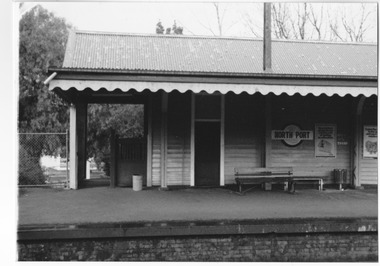
Photograph - North Port railway station, day of last train from Port Melbourne, Joan Curtis, c. 1991
Photographed by Joan CURTIS on the last day the trains ran. Prints made by Pat Grainger from Joan's negs during the 'Vintage Port' Project, 1990North Port railway station, photographed day of last train from Port Melbourne, October 1987: east side (Bay bound), northern endDetails in black ink on backtransport - railways, built environment, joan curtis -
 Port Melbourne Historical & Preservation Society
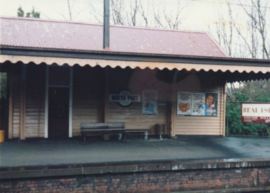
Photograph - North Port railway station, day of last train from Port Melbourne, Joan Curtis, c. 1991
Photographed by Joan CURTIS on the last day the trains ran. Prints made by Pat Grainger from Joan's negs during the 'Vintage Port' Project, 1990North Port railway station, photographed day of last train from Port Melbourne, October 1997: east side (Bay bound), southern endDetails in black ink on backtransport - railways, built environment, joan curtis -
 Newcomb Secondary College Archives
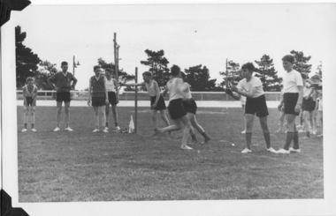
Photograph - Geelong East Technical School 1958 Athletic Sports, Geelong East Technical School 1958 Athletic sports at the Western Oval, Geelong
Geelong East Technical School opened in 1958. This photograph is from the first Athletics Sports day held at the Western Oval, North Geelong.First athletic sports day held at the Western Oval, North Geelong, 1958.geelong east technical school. -
 Monbulk RSL Sub Branch
Book, William Heinemann, Sandakan : the untold story of the Sandakan Death Marches, 2013
The untold story of the Sandakan death marches of World War II. After the fall of Singapore, in February 1942, the Japanese conquerors rounded up tens of thousands of British and Australian soldiers and shipped them to prison camps scattered throughout Hirohito's newly won Empire. The fall of Britain's 'impregnable fortress' was the greatest humiliation in British military history, for which Churchill never forgave the Japanese. But nothing would surpass the wretched fate of some 2,700 British and Australian prisoners who were shipped to British North Borneo later that year. They landed in Sandakan, on the east coast of the island, after a 10-day voyage on a Japanese 'hell' ship, and were herded into a jungle camp some eight miles inland. Thus began the three-year ordeal of the Sandakan prisoners of war - a barely known story of unimaginable horror.Index, bibliography, notes, ill, p.688.non-fictionThe untold story of the Sandakan death marches of World War II. After the fall of Singapore, in February 1942, the Japanese conquerors rounded up tens of thousands of British and Australian soldiers and shipped them to prison camps scattered throughout Hirohito's newly won Empire. The fall of Britain's 'impregnable fortress' was the greatest humiliation in British military history, for which Churchill never forgave the Japanese. But nothing would surpass the wretched fate of some 2,700 British and Australian prisoners who were shipped to British North Borneo later that year. They landed in Sandakan, on the east coast of the island, after a 10-day voyage on a Japanese 'hell' ship, and were herded into a jungle camp some eight miles inland. Thus began the three-year ordeal of the Sandakan prisoners of war - a barely known story of unimaginable horror.world war 1939-1945 - prisoners of war - sandakan, japan - prisons and prisoners of war -
 Bendigo Historical Society Inc.
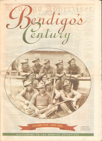
Newspaper - LONG GULLY HISTORY GROUP COLLECTION: BENDIGO'S CENTURY VOLUME FIVE: 1940 - 1949
Newspaper supplement titled Bendigo's Century Volume Five: 1940 - 1949. Each year has heading of Who's Who, Weather, Sport and Business. Front page is titled Bendigo's Century and has a photo of a group of soldiers in uniform and with rifles. They were district servicemen on leave in 1944. Each year has heading of Who's Who, Weather, Sport and Business. First years are 1940 - 1949 titled Bendigo as it was. It has two photos of women wading through the 1949 Pall Mall flood waters and one of Miners in the crib room of the Central Deborah Mine. They are Jackie Lewis, Bob Johnson, W Landy, Ryga Yates and Les Johnson. 1940 - Army moves in to racecourse, 1941 - Devastating fire at pottery, 1942 - Forces expand, 1943 - Nation's eyes on Bendigo, 1944 - News dawns of D-day landing, 1945 - City cheers the end of the war, 1946 - Celebrations begin in city, 1947 - Gallery gets top paintings, 1948 - Water plan looks good and 1949 - Flood takes a toll on city.bendigo, history, long gully history group, the long gully history group - bendigo's century - volume five: 1940 - 1949, bendigo advertiser, central deborah mine, jackie lewis, bob johnson, w landy, ryga yates, les johnson, central nell gwynne, department of defence, bendigo jockey club, 8th division, robert menzies, deborah mine, bendigo decentralisation vigilance committee, cr w h taylor, bendigo war funds organisation, the easter fair society, bendigo agricultural show committee, mr e g ham, mr j v fairbairn, cr a staples, the bendigo chamber of commerce, richard hartley smith abbott, captain harley abbott, bendigo art gallery, bill woodfull, bendigo high school, north deborah mine, boardwalk, toni riley pharmacy, windermere hotel, cr g a pethard, coliban system, north deborah mine, bendigo pottery, bendigo trades hall council, private lawrence burstall, major-general g j rankin mhr, andrew dunstan, ordnance factory, royal australian navy, hmas bendigo, sec offices, muioof, ymca, georger addlem, fred addlem, cr a j anderson, pauline buvhan thompson, leslie thompson, edward joseph leonski, bendigo football league, mr j dedman, william stephens, forest street methodist church, pte charles phillips, pte w e durward, pte t foley, william john stephens, central nell gwynne, air chief marshall sir arthur tedder, cr taylor, united nations, flying officer, r bruce tuff, flight lieutenant owens, royal air force, commonwealth war workers housing trust scheme, mr s mckinnon, bendigo decentralised vigilance committee, ravenswood estate, john lienhop mlc, margaret (peggy) brennan, strathfieldsaye shire council, school of mines, bendigo base hospital, william george ashman, ashman's tailors, bendigo jockey club, victorian football association, bendigo east swimming pool, deborah anticline, specimen hill methodist church, north deborah, adolf hitler, benito mussolini, australian 7th division, cr galvin, bendigo war funds organisation, hmas bendigo, lt-commander jackson, bendigo football league, central deborah mine, victoria day, cr truscott, bendigo gaol, lansellstowe, awas barracks, bendigo citizens committee, john cain snr, ordnance factory, bendigo agricultural society, the duke of gloucester, duchess of gloucester, bendigo tennis association, north deborah, gillies famous pies, aids & appliance shop, mrs georgina scott, dr j a neptune scott, alfred sisley, corot, daubigney, louis sonnenberg, gas employees' union, john lienhop, soldier settlement commission, burnewang estate, king george vi, princess elizabeth, lt philip mountbatten, mr e j w herbert, ansett airways, reg ansett, most rev, dr john mccarthy, dr bernard stewart, michael giudice, bendigo united breweries, bendigo lyric photo plays, bendigo sun newspaper, shamrock hotel, west bendigo progress association, alan mcdonald, south bendigo football club, albert collier, j t webbo, mervyn tresize, state rivers and water supply commission, eppalock reservoir, public works committee, bendigo rotary club, john edgar, bendigo base hospital, albert dunstan, benevolent home, magetti's wine hall, wallace reef wine hall, magetti family, albert magetti, lance galvin, bradford cotton spinnings (victoria) pty otd, arthur syer, stanley crossman, albert arthur dunstan, rev dr henry backhaus, city family hotel, lyric theatre, bank of australasia, city club hotelcolonial mutual building, r matchett & co, lansellstowe, leonard lansell, bendigo bas hospital, australian women's army service, mr hollway, kenworth (aust) ltd, foggitt jones's bacon factory, gordon sayers, sandhurst trustees, dr john drowley, alexander hislop, royal mint, north deborah mine, ironbark south mining company, central nell gwynne company, new chum syncline -
 Uniting Church Archives - Synod of Victoria
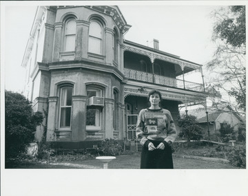
Photograph, "Seeking and finding harmony in a confused world - but it's costly", 1985
Part of an article about the UC's work amongst aged people. Cameron House was in North Fitzroy where day care programs were being offered, but funding was being withdrawn, and a public meeting was reported on. Pamela Walsh was the manager of the programs.Walsh is shown standing in front of a 19th C. Cameron House.Identification of person and source.aged care programs, cameron house -
 Old Colonists' Association of Ballarat Inc.
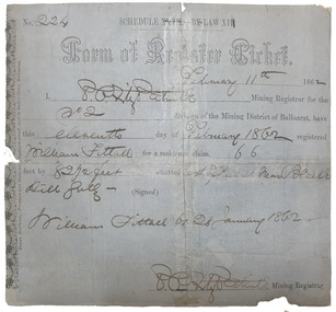
Document, Form of Register Ticket made out to William Fittall, 1862
Small ticket stub for a Form of Register TicketForm of Register Ticket No. 224 Schedule XXVII By Law XIII February 11th 1862 I, P.P.FitzPatrick Mining Registrar for the No 2 division of the Mining District of Ballaarat, have this eleventh day pf February 1862 registered Willia Fittall for a residence claim, 66 feet by 82 1/2 feet situated east of Peel Steeet near Black Hill Gully (signed) William Fittall on 28 January 1862sailor, immigration, thomas paterson, greenock, george dempster, chevalier -
 8th/13th Victorian Mounted Rifles Regimental Collection
Photograph
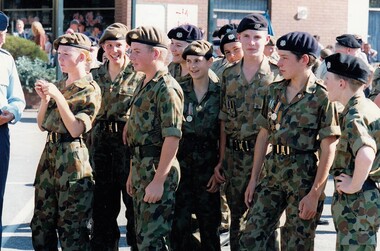
37 Regional Cadet Unit based in Albury and North East Victoria received official permission to wear 8/13 VMR badge.Colour photograph of group of Army Cadets on Anzac Day 1994 at Albury. Some are wearing 8/13 Victorian Mounted Rifles beret badges. Unit is 37 Regional Cadet Unit.cadet, vmr, military, anzac day, albury -
8th/13th Victorian Mounted Rifles Regimental Collection
Document - Admin Inst Anzac Day
... communities in North East Victoria. Anzac Day Wangaratta Cobram ...Example of planning involve in regimental support to local communities in North East Victoria.Typed Administrative Instruction for 'A' Squadron 8/13 Victorian Mounted Rifles support to Anzac Day activities i local communities: Albury Benalla, Corowa, Cobram, Finley, Strathmerton and Tocumwal. Five pages including list of appointments.anzac day, wangaratta, cobram, benalla, corowa, finley, strathmerton, tocumwal, albury, vmr -
 Ballarat Tramway Museum
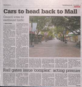
Newspaper, The Courier Ballarat, "Cars to head back to Mall", "Rail Gates issue 'complex': Acting Premier", 25/03/2021 12:00:00 AM
Newspaper clipping from The Courier, 25/3/2021, titled "Cars to head back to Mall" about the return of east bound traffic back to Bridge St Mall, following a City of Ballarat decision the previous day. Story by Jolyon Attwooll. Underneath is a story by Alex Ford about the Lydiard St North level crossing gates which were damaged by a Velocity set out of control during May 2020. Quotes the Acting Premier, James Merlino. All pending a accident report. Titled "Rail Gates issue 'complex': Acting Premier" See Reg Item 8108 for the next chapter - booms to be installed.bridge st, bridge mall, city of ballarat, level crossings, lydiard st nth, accidents