Showing 85 items
matching parish of south melbourne
-
 Whitehorse Historical Society Inc.
Newspaper - Article, Mothers in Ministry
Article in Nunawading Gazette. Rev Clemence Taplin recently took over at Holy Name Anglican Church, South Vermont. She is due to have her 2nd child in 2 months and then Rev Christine Simes will relieve her. She thinks it is probably the first occasion that two women shared the job as a Parish Priest.holy name anglican church, vermont south, churches, vermont south, taplin, clemence (rev), simes, christine (rev) -
Whitehorse Historical Society Inc.
Map, Melbourne Metropolitan Area Base Map, 1957?
Sheet 254 of part of the Municipality of Nunawading and part of the Parish of Nunawading, showing roads, block numbers, creeks and contours mostly south of Canterbury Road.Sheet 254 of part of the Municipality of Nunawading and part of the Parish of Nunawading, showing roads, block numbers, creeks and contours mostly south of Canterbury Road. Prep. from State Aerial and Cadastral survey information, August 1957. Scale: 400 ft = 1 inchSheet 254 of part of the Municipality of Nunawading and part of the Parish of Nunawading, showing roads, block numbers, creeks and contours mostly south of Canterbury Road. city of nunawading, cadastral -
Whitehorse Historical Society Inc.
Map, Township of Norwich, ca 1850
Plan of the Township of Norwich being subdivision of Section III, Parish of Nunawading, County of Bourke, consisting of suburban farms, vineyard sites and town lots, for sale by auction by W. Casey & Co. [c. 1850]. Original in Vale Maps Collection, La Trobe Library.norwich village, vermont, parish of nunawading, vermont south, maps -
 Whitehorse Historical Society Inc.
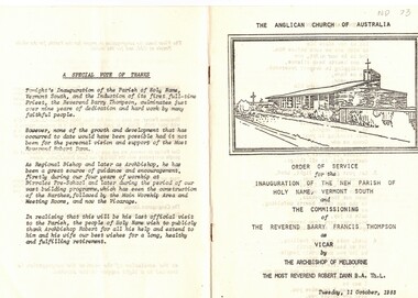
Document, Parish of Holy Name, 1/10/1983
Order of Service for the inauguration of the new Parish of Holy Name, Vermont south and the commissioning of Reverend Barry Francis Thompson as Vicar by the Archbishop of Melbourne, the Most Reverend Robert Dann on Tuesday, 11 October, 1983. a tribute is included to the involvement of Archbishop Robert Dann over the previous nine years to the development of the Parish. 12 pagesholy name anglican church, vermont south;, dann, robert, rev., thompson, barry francis -
Whitehorse Historical Society Inc.
Map, Melbourne and Metropolitan Board of Works, Feb 1982
Map area: North - Laburnum and Blackburn Stations East - Blackburn Lake South - bordering Canterbury Road West - Middleborough Roadnon-fictionMap area: North - Laburnum and Blackburn Stations East - Blackburn Lake South - bordering Canterbury Road West - Middleborough Roadmaps, melbourne and metropolitan board of works, parish of nunawading -
 Bendigo Historical Society Inc.
Document - BOARD OF WORKS, MELBOURNE: CONTRACTS ACCEPTED & LAND SALES FOR 1860
Page 2223 titled Contracts Accepted - (Series 1860). Contracts accepted are for Raising and removing sunken ship Marilla; Removal of Toll-gate from Mount Alexander Road and re-erection of same at Middle Gully; Erection of toll-house on Melbourne/Ballarat Road near Ballan; Erection of toll-house on Bendigo Road at Kangaroo Flat; Castlemaine to Ballarat - Erection of toll-house at Campbell's Creek; Construction of 2870 chains of Lower Western Road, west of Camperdown; Erection of two bridges and other improvements on the Clunes to Amherst Road; Erection of timber bridge, & c., over Two-mile Creek - Beechworth to Bowman Forest; Formation of roadway at head of Buckland Gap - Beechworth to Bowman Forest; Construction of culvert, & c., Rowe's Creek - Beechworth to Bowman Forest; Ararat and South-western sea-board road - erection of bridge over Dennicull Creek and other improvements. Land Sales - 4 Lots - Elsternwick, parish of Prahran, County of Bourke; 2 Lots - Dandenong, County of Bourke; 20 Lots - Lillydale, Parish of Yering, County of Evelyn, 1 suburban Lot - County of Evelyn, Parish of Yering; 1 Allotment - Romsey, County of Bourke, Parish of Lancefield; 5 Lots - County of Mornington, Parish of Langwarrin, and 2 Lots - County of Mornington, Parish of Fingal. Lots to be sold at the Auction Rooms of Mr. William Perry, Great Collins Street, Melbourne. A F A Greaves, President, Office of the Board of Land and Works, Melbourne.bridge, construction, timber bridges, board of works, melbourne - contracts accepted & land sales, 'marilla', f m pingree, jno r bailey, robert heron, john gray, donald ross, hector mclean, c j glynn and co, john nicholls and co, michael cleary, thomas cairncross, brown and gibson, queen victoria, mr william perry, mr de castella, willoughby, barker, a f a greeves, board of land and works melbourne -
Surrey Hills Historical Society Collection
Work on paper - Newspaper article and photo, The Age, Farewell to the sisters, 15 December 1967
Sisters from St Joseph's Convent at 1 Kent Road, Surrey Hills taught at Our Holy Redeemer School in Mont Albert Road from 1902-1967. Formally known as Sisters of St Joseph of the Sacred Heart, they were often called the Josephites or 'Brown Joeys' on account of their brown habits. The order was founded by Saint Mary MacKillop (1842–1909). The order originally transferred to Surrey Hills from South Melbourne where they ran a Home for Destitute Children. The last 3 sisters from Surrey Hills transferred to the Gisborne parish in December 1967. A yellowed newspaper article with a photo depicting two nuns with 4 children, 3 girls and 1 boy facing the sisters but with their backs to the photographer. Background is a brick wall.our holy redeemer school, st joseph's convent, sisters of st joseph of the sacred heart, josephites, brown joeys, gisborne, sister teresa, sister albert, sister edmund, brendan hutchinson, helen fremantle, kelly ryan, marietta urh, school children, uniforms, nuns -
Surrey Hills Historical Society Collection
Work on paper - Program, Our Holy Redeemer Mothers' Club, Our Holy Redeemer Mothers' Club concert program, c 14 December 1967
Sisters from St Joseph's Convent at 1 Kent Road, Surrey Hills taught at Our Holy Redeemer School in Mont Albert Road from 1902-1967. Formally known as Sisters of St Joseph of the Sacred Heart, they were often called the Josephites or 'Brown Joeys' on account of their brown habits. The order was founded by Saint Mary MacKillop (1842–1909). The order originally transferred to Surrey Hills from South Melbourne where they ran a Home for Destitute Children. The last 3 sisters from Surrey Hills transferred to the Gisborne parish in December 1967. A yellowed and grubby paper printed in black detailing 7 songs / dance items performed by students from Prep to Grade 6.1967 handwritten in grey pencil to the right of the printed time and date.our holy redeemer school, st joseph's convent, sisters of st joseph of the sacred heart, josephites, brown joeys, gisborne, sister teresa, sister albert, sister edmund, brendan hutchinson, helen fremantle, kelly ryan, marietta urh, school children, uniforms, nuns -
 Surrey Hills Historical Society Collection
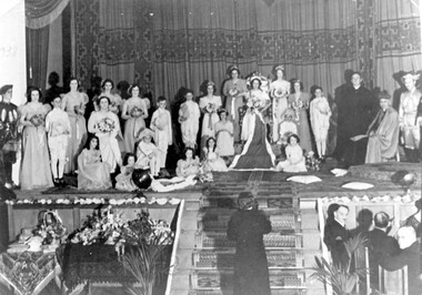
Photograph, Holy Redeemer Queen Carnival, 1938, 1938
Donor identifies the following: Parish priest - Dr W M Collins Queen - Molly Baker Attendants - Marg Wise, Lola Sans, Gertie Baker Flower girls - Madge Wise, Molly Brown, Rita O'Sullivan Probably taken in Our Holy Redeemer Hall, Mont Albert Road, Surrey Hills.This is one of only a few photos in our collection which are evidence of Queen Carnivals which originated as fundraising events. They were particularly popular in both Australian and New Zealand during the early 20th century. They were particularly common during and after World War I when they were used to raise funds for returned soldiers. It is currently the only photo in the collection of a social event connected to Our Holy Redeemer Church and the only one which includes Dr William M Collins who was the parish priest from 1933-1941. Dr Collins was a significant figure in the Catholic Church in Melbourne in the first half of the 20th century. REF: The Advocate: The first priest-editor by Fiona Power; Kairos Catholic Journal Volume 22, Issue 16. - 2 September 2011": Summary: Born in Kilmore in 1884, William Collins attended South Melbourne College and then the University of Melbourne, where he assisted in the formation of the Newman Society of Victoria. After graduating in arts in 1911, he worked at the Melbourne Public Library and the Education Department. In 1912, at the age of 28, he went to Rome, where he studied for the priesthood at Urban College. He obtained doctorates in philosophy and theology and was ordained on 3 June 1917. He returned to Melbourne and was appointed curate at St Mary’s, West Melbourne, and St Francis’, Lonsdale Street. In 1918, Dr Collins became editor of The Advocate. He remained in the role for seven years. Dr Collins was parish priest of Dandenong, Daylesford, East Malvern, Surrey Hills and Kew, and administrator at St Francis’. He died in 1959 and a Requiem Mass was held at Sacred Heart, Kew. Black and white photo of the participants in the Queen Carnival arranged on a stage in a tableaux of the coronation of the Queen. To the right are the parish priest and the archbishop and there is a man at the bottom of the stairs centre front of the stage. Guests are seated at a table to the right of the stairs and to the left of the stairs is a table with floral arrangements and other objects. "1938" hand-written on the original photo in upper LH corner.festivals and celebrations, queen carnivals, our holy redeemer church, dr w m collins, rev william m collins, (miss) molly baker, (miss) marg wise, (miss) lola sans, (miss) gertie baker, (miss) madge wise, (miss) molly brown, (miss) rita o'sullivan -
 Ballarat Diocesan Historical Commission
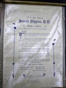
Address on silk scroll, Address of welcome
Address of Welcome to Bishop Higgins of Ballarat on his first official visit to the Clunes parish which then included Talbot, Smeaton and Lexton.An old stamp to bottom of scroll showing formerly held in the Melbourne Diocesan Historical collection.talbot, clunes, smeaton, lexton, higgins, ballarat silk scroll, address of welcome. -
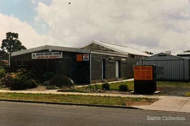 Melton City Libraries
Photograph, Melton Uniting Church Opportunity Shop, 1975
Edna Barrie founded the Church Opportunity with Maisie Robinson in 1975 in the Melton South Methodist Church building. Methodist and Presbyterian Churches of Melton had combined severing their long held connection with Bacchus Marsh. A Manse had been recently built for the Melton Minister. At a Parish Committee meeting at the Melton South Church it was suggested to use the building as an Opportunity Shop. It opened in July 1975, and it raised $1,600 contribution to the church budget in 1976. In 1977 The Uniting Church in Australia was formed and the Melton South Uniting Church Opportunity shop continued to go from strength to strength expanding the buildings providing the welfare needs of the community. Melton Uniting Church Opportunity Shop, view from Brooklyn Road.churches -
 Bendigo Historical Society Inc.
Map - BENDIGO SHEET 2
Parish map showing the southern section of the City of Bendigo. It shows the city boundary running along Murphy Street, Grave (Patterson) Street, and the turns at the south end of Macdougall Road, the corner of Alder and Aspinal Streets and the corner near the Specimen Hill - Marong roads intersectionH.J. Green Govt. Printer, Melbournemap, bendigo, city streets, parish map, city boundary -
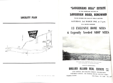 Ringwood and District Historical Society
Document - Folder, Subdivision Auction - Loughnans Hill Estate 1962, Ringwood, Victoria
Double-sided bifold page advertising auction on Saturday 3rd March, 1962 - 13 residential allotments in Hearthside Court and 6 shop sites in Loughnan Road, with map of subdivision, terms of sale, and summary of features and services. Adjoining service station shown on accompanying Plan of Subdivision - Part of Crown Allotment 28 Parish of Warrandyte, also showing location of property known as "Hearth", hence Hearthside Court.Auctioneers - Baillieu Allard Real Estate Pty Ltd., 360 Collins Street, Melbourne, and 302 Toorak Road, South Yarra. Telephone 24-4365, After hours XU1549, WL2471. -
 Eltham District Historical Society Inc
Photograph - Digital Photograph, Marguerite Marshall, Wingrove Cottage, Main Road, Eltham, 8 June 2006
Wingrove Cottage built 1858-1859 of hand made bricks is historically significant for its long association with Charles Wingrove, a prominent figure in Victorian local government, as secretary to the Eltham District Road Board and Shire Council from 1858 to 1904, and Shire Engineer and Secretary to the Heidelberg Road Board. The cottage was used as the office of the Eltham District Road Board and Council for many years It is one of the Shire's oldest dwellings, and one of the few surviving 19th century buildings associated with early Eltham and located in the original Eltham Village Reserve. The symmetrical planting of a pair of Pencil Pines (not visible in photo) is also historically and aesthetically significant as characteristic of the early period of planting in the district and because they are a distinctive landscape feature. In October 2002 new owners demolished the outbuildings attached to the rear of the cottage. Community protest at the demolition resulted in Council issuing a Stop Work order. The owner was issued with a court order in September 2003 to develop a conservation management plan and restore the heritage listed property. The owner sold the property in 2005 to Cameron Construction in 2005 who undertook the restoration work. In 2007 a planning application to build two offices and seven dwellings at the rear of the property was ultimately rejected. The cottage is now the main office for Cameron Construction. Covered under Heritage Overlay, Nillumbik Planning Scheme. Published: Nillumbik Now and Then / Marguerite Marshall 2008; photographs Alan King with Marguerite Marshall.; p57 Wingrove Cottage on Main Road beside Eltham Primary School, is one of the Shire’s most important historical buildings and was central to local government for almost 50 years. The cottage was built in stages from 1858 to 1888 for Charles Symons Wingrove JP. He was the Eltham District Road Board’s first paid secretary and later the Shire Secretary when the board became the Eltham Shire Council. Wingrove held those positions, and that of engineer for a time, for 46 years. He was also one of the main figures in the Municipal Association of Victoria. As Eltham’s first paid municipal officer, Wingrove used one room in his 11 – (originally two) roomed home, as the office for the board then the council. Meetings were held there from the late 1850s (as well as at more central locations) until Wingrove’s retirement in 1904. The cottage is a rare example of a local government office occupying a Road Board /Shire Secretary’s purpose-designed house. The cottage is also significant because it is the oldest largely intact building from the original Eltham township reserve (south of Dalton Street).1 The township had its origins in the 1848 Nillumbik Parish Plan and was one of the state’s earliest township reserves. The rectangular house of handmade bricks, roofed with grey slate tiles and with a veranda encompassing three sides, is reminiscent of those in the central goldfields including Castlemaine. Its overhanging eaves and gables were unlike houses in Melbourne at the time. Wingrove, who was born in 1827, had been a gold digger and a road surveyor. Impossible to imagine in today’s world, Wingrove was also the Shire of Heidelberg’s secretary and engineer for part of the time that he was secretary in Eltham. Living next door to the primary school was a mixed blessing. Wingrove and his wife Katherine, who had ten children, sent their eight surviving children to the school. But they had occasional disputes with the school authorities when their cattle wandered into the schoolyard. Eltham showed Charles Wingrove its appreciation of his services by giving him two illuminated addresses, one after ten years and the other at retirement. Wingrove died in 1905 aged 76 and was buried in the St Katherine’s Church of England cemetery in St Helena. His grave is surrounded by those of family members including his wife, Katherine and two babies, Henry, 12 months and Isobella, 15 months, who died in the mid-1860s. Cottage ownership passed to his wife, then to daughter Caroline and then to daughter Bessie, a Melbourne University graduate and artist. During the Great Depression their brother Walter was the ratepayer. At one stage the Wingrove property extended to Metery Road and included a small creek. The family ran a small dairy and orchard, with associated farm buildings, which were later removed. In 1949 part of the property was compulsorily acquired by the Eltham Primary School, which infuriated owner Bessie Wingrove. She protested in a letter about this ‘monstrous act of unmitigated tyranny’.2 She was the last Wingrove to occupy the cottage and died in 1955. Wingrove descendants sold the house in 1974 and the property was subdivided. In the 1960s the Eltham Shire named the park opposite the cottage in Wingrove’s honour. The cottage has since had several owners including psychiatrist Dr Daniel Kahans, who practised there. In October 2002 late rear additions which had been substantially altered were demolished contrary to council planning controls. This caused a community outcry and resulted in legal proceedings against the owner. Fortunately the historical significance of the demolished section was not as great as the older front part of the building, which has been retained and was later restored.This collection of almost 130 photos about places and people within the Shire of Nillumbik, an urban and rural municipality in Melbourne's north, contributes to an understanding of the history of the Shire. Published in 2008 immediately prior to the Black Saturday bushfires of February 7, 2009, it documents sites that were impacted, and in some cases destroyed by the fires. It includes photographs taken especially for the publication, creating a unique time capsule representing the Shire in the early 21st century. It remains the most recent comprehenesive publication devoted to the Shire's history connecting local residents to the past. nillumbik now and then (marshall-king) collection, cameron construction, charles symons wingrove, eltham, eltham road district board, eltham shire council, main road, wingrove cottage -
 Eltham District Historical Society Inc
Photograph - Digital Photograph, Alan King, Sweeney's Cottage, Sweeneys Lane, Eltham, 30 January 2008
Part of the original cottage named Culla Hill built by Thomas Sweeney (a former convict) remains as a small section of today’s house. Covered under Heritage Overlay, Nillumbik Planning Scheme National Estate National Trust of Australia (Victoria) Local Sifgnificance Published: Nillumbik Now and Then / Marguerite Marshall 2008; photographs Alan King with Marguerite Marshall.; p19 Thomas Sweeney, a former convict who became a respected citizen, once lived on a property at what is now the corner of Sweeneys Lane and Culla Hill, Eltham. As Sweeney was one of the district’s first settlers, the property is registered by the National Trust. Thomas Sweeney was born in 1802, son of impoverished tenant farmers in Tipperary County, Ireland. He became a ploughman, then at 21 he was sentenced to hang for setting on fire the house of Patrick Guyder at Gullshill. It is said the arson was due to a dispute over undelivered guns to a social justice guerilla group, the White Boys, of which Sweeney was a member. But the sentence was commuted to life transportation to Australia in 1823.1 Apparently in Sydney he became a servant to James Chandler at Botany. Soon James Chandler leased his farm and became a catechist on the Hawkesbury River, so Sweeney was reassigned to a former convict, John Brown, at Liverpool. Later Sweeney was assigned to George Brown of Lake Illawarra. In 1831, Sweeney was granted a ticket-of-leave and bought a boat to carry goods between Illawarra district and Sydney Town. He married his first wife who had come to Australia as a free woman. However she drowned after bearing him a daughter. In 1838, one month after he had received a conditional pardon, Sweeney married a blacksmith’s daughter, Margaret Meehan, newly arrived from Ireland. They then moved to Port Phillip and squatted on the south side of the Yarra River, about seven miles (11km) from Melbourne. Around 1842, Sweeney bought 110 acres (44.5ha) in the parish of Nillumbik for £110. He built a slab hut 12 x 10 feet (3.6m x 3m) and then his homestead, Culla Hill, a typical Tipperary style cottage, now known as Sweeney’s Cottage. It was here that many generations of Sweeneys lived for almost 100 years. Culla Hill became a social centre for the district and the Catholic community used it as a church. Sweeney was apparently on good terms with a tribe of Aborigines living on the river nearby, who helped him build his house.2 Sweeney proved himself a civic-minded leader. In 1844, he led a call for a bridge over the Plenty River. He was on the first school board and supplied the first grain for Eltham’s mill. Sweeney profited during the gold rush, not by gold digging, but by providing supplies for nearby fields and others as far away as Beechworth.3 Thomas Sweeney died in 1867 and was buried at the Eltham Cemetery, leaving two sons, five daughters, and 300 acres (121.4ha), as well as Culla Hill. Culla Hill – by then reduced to 75 acres (30ha) – was sold out of the family in 1939, then renamed Sweeneys. The present Sweeneys Lane, running diagonally through the original holding, was the track to the house. Part of the original cottage remains as a small section of today’s house. The dining-family room fronted by a veranda is original, and although there have been some changes, the cedar door and most of the small 12-paned wooden-framed windows are original. The walls are made of the original hand-made brick. After buying the property in 1952 Mr and Mrs Burston demolished a dilapidated slab hut, a three-roomed detached kitchen and cellar, as materials needed to restore them were very difficult to obtain so soon after the war.4 However the barn remains almost in its original condition. It is believed to have been built from stone quarried on the property. Now roofed with iron sheets it was probably originally thatched. The sandstone barn has a peaked roof supported by the original saplings and a doorway large enough to accommodate a fully loaded wagon.This collection of almost 130 photos about places and people within the Shire of Nillumbik, an urban and rural municipality in Melbourne's north, contributes to an understanding of the history of the Shire. Published in 2008 immediately prior to the Black Saturday bushfires of February 7, 2009, it documents sites that were impacted, and in some cases destroyed by the fires. It includes photographs taken especially for the publication, creating a unique time capsule representing the Shire in the early 21st century. It remains the most recent comprehenesive publication devoted to the Shire's history connecting local residents to the past. nillumbik now and then (marshall-king) collection, culla hill, eltham, sweeney's cottage, sweeneys lane, thomas sweeney -
 Bacchus Marsh & District Historical Society
Map, Allotments in the Village of Rowsley, Parish of Gorrocburkghap, County of Grant c.1856
Rowsley is a locality 11 kilometers south-west of Bacchus Marsh. The date of this map is uncertain. A very similar map held by the State Library of Victoria (SLV) contains slightly more information than this copy and is dated as an 1856 map. SLV reference: 'Allotments in the Village of Rowsley, Parish of Gorrocburkghap, County of Grant', by T. Nixon, Assistant Surveyor, May 1856 ; Surveyor General’s Office, July 18 1856 (lithographed by R. Meikle). (1856). Melbourne: Surveyor General’s Office. MAPS 820 BJE 1837- ROWSLEY 1856. A single page paper map. A cadastral map of the Village of Rowsley in Victoria, showing numbered land allotments. 57 allotments are shown on the map and some areas set aside as reserves. Allotments 8, and 10-16 are outlined in red ink and allotment 9 has a cross in red ink on it. The map is pasted into a bound volume containing 76 maps or plans in total. High resolution digital image stored on BMDHS computer network. rowsley victoria history, rowsley victoria maps -
Glen Eira Historical Society
Article - St Peter's Catholic Church, Bentleigh East
Included In The File is A Newspaper Clipping From The Age Newspaper, Dated Sat 09/11/1974 On The Opening Written By Stuart Sayers. The Article Mentions A Brief History Of The Church & School Beginnings & The Opening Ceremony. There Are Two Copies Of The Living Harvest (One Without The Cover), The Book Gives A Detailed History Of St Peter's Catholic Church, Bentleigh East Written By W.T. Dobson And Published in 1974. From The First White Settlers, The Irish Exodus, And The Irish Catholic families, The School House And The History Of The Parish & Clergy Up To 1974.st peter's catholic church, niall patrick rev, emerald hill, bentleigh east, dobson w. t., yarra, moorabbin, heriot m. b., elsternwick, north road, quinn fred, bentleigh, centre road, kennedy james joseph, melbourne south, bignell road, kennedy market garden, oakleigh, st peter's parish, st james parish, the living harvest, catholic church, hibernian society, bavarian brass band, st peter's primary school, st james regional college, brighton catholic school, brighton – st kilda mission, niall patrick william fr, dendy henry, guiney john mr, king richard, king john, keys george, o’ shanassy john, keys robert, were jonathan b., o’ connell john fr, glass hugh mr, o’ farrell peter, brady peter, kennedy james, boland michael, mccormick francis, orrong road, little brighton, oakleigh, port phillip bay, east boundary road, north road, ormond, old dandenong road, mordialloc creek, moorabbin, springvale, no good damper road, kingstown, keysborough, bignell road, south road, heatherton, big brighton, gardenvale, elsternwick, brady road, jasper road, chesterville road, cochrane road, mcguinness road, h.a.c.b.s., school house, st patrick's church, brighton parish, denominational school, little brighton school, moorabbin catholic school, temporary chapel, st james regional college, sister of mercy, lanigans ball, east brighton public hall company ltd, east bentleigh hall, messrs. robert dunn & son, bavarian brass band, st joan of arc parish, east bentleigh parish, the sisters of our lady of sacred heart, the anchor club, mccormick cornelius, cochrane james, cochrane david, mcguinness margaret, cormick john, cahill james, quinn frederick, prendegast john patrick, naughton dennis, leary william, charlston john, carey matthew fr, gibbons patrick, kennedy joseph james, o’ sullivan tim fr, mckenna fred fr, casey william fr, browne joseph fr, crawford mal fr, hanrahan mr, gillon rose miss, sampson kate mrs, horan miss, coakley daniel fr, dillon kevin fr, whitehouse ray fr, mannix daniel dr, dobson william mr, gahan patrick, hallinan thomas, delaney john, fitzgerald patrick, st peter's catholic church -
City of Moorabbin Historical Society (Operating the Box Cottage Museum)
Newsletter - CMHS October 2013 pdf, October 2013
The City of Moorabbin Historical Society was formed c 1960 by a group of Moorabbin area residents who were concerned that the history of the area should be preserved. A good response to a call for items related to the historical area of Moorabbin Shire brought donations of a wide variety of artefacts that are now preserved by the current members of CMHS at Box Cottage Museum. Helen Stanley, Secretary of CMHS, began producing a Newsletter for members in April 2007 to provide current information and well researched items of historical interest. Jim Dale continued to produce the Newsletter in 2013 after Helen resigned.5 x A4 paper with Colour photos Jim Dale recounts the Commemoration of Harry Hawker and Harry Kauper’s landing at Loughshinny, County Fingal Ireland in August 1913. At our August Open Day Elizabeth Miller MP for Bentleigh and Jamie Hyams, CMHS member and Mayor of Glen Eria welcomed the Hawker Family on their visit and display on their relative Harry George Hawker. On the same day and we watched the days event in Loughshinny when Project Hawker 2013 with Jeff Boying and his crew in their Catalina came to the end. A spark plug which was retrieved from Hawker's aircraft at Loughshinney in 1913 will be forwarded to CMHS However,an item that was to be of National importance could not be safely stored at the Box Cottage Museum. On 5th September, the Director of RAAF Museum Point Cook, Victoria, Mr David Gardener received the 'Spark Plug ' from Jim and Chris Hawker Notices for members re AGM in October. Jim has compiled a 'History of The Cheltenham Scouts' 1911 (1909) - current.City of Moorabbin Historical Society Newsletter October 2013.city of moorabbin historical society, stanley helen, dale jim, melbourne, moorabbin, brighton, cheltenham, ormond, bentleigh, market gardeners, pioneers, early settlers, the moorabbin roads board 1862, city of glen eira, city of kingston, moorabbin shire, parish of moorabbin, brighton east, south brighton, bent tommy, scouting australia, cheltenham scout group, hawker harry, aeroplanes, moorabbin airport, world war 1, baden-powell sir robert -
 City of Moorabbin Historical Society (Operating the Box Cottage Museum)
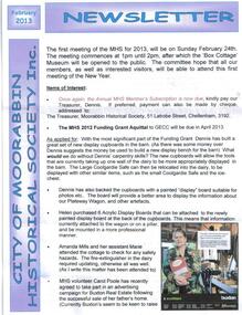
Newsletter - City of Moorabbin Historical Society Feb 2013, February 2013, December 2012
The City of Moorabbin Historical Society was formed c 1960 by a group of Moorabbin area residents who were concerned that the history of the area should be preserved. A good response to a call for items related to the historical area of Moorabbin Shire brought donations of a wide variety of artefacts that are now preserved by the current members of CMHS at Box Cottage Museum. Helen Stanley, Secretary of CMHS, began producing a Newsletter for members in April 2007 to provide current information and well researched items of historical interest Helen Stanley has produced a bi-monthly Newsletter, 2007 - 2013, for the members of the City of Moorabbin Historical Society that contains well researched interesting historical items, notification of upcoming events, current advice from Royal Australian Historical Society , Museums Australia Victoria and activities of Local Historical Societies. The Newsletter is an important record of the activities of the CMHS.5 x A4 paper printed on 1 side Issue 30 of the bi-monthly, City of Moorabbin Historical Society Newsletter produced by Society member and Secretary, Mrs Helen Stanley in February 2013 includes a Calendar of Dates for Open Days and meetings in 2013. and notes from 'A History of Market Gardens in Victoria 1850 - 1939' by Joanne Monk in1992 CITY of MOORABBIN HISTORICAL SOCIETY / FEBRUARY 2013 NEWSLETTERcity of moorabbin historical society, stanley helen, monk joanne, melbourne, moorabbin, brighton, cheltenham, ormond, bentleigh, market gardeners, pioneers, early settlers, the moorabbin roads board 1862, city of glen eira, city of kingston, moorabbin shire, parish of moorabbin, brighton east, south brighton, bent tommy, -
 City of Moorabbin Historical Society (Operating the Box Cottage Museum)
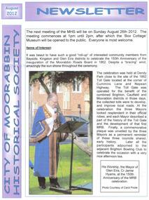
Newsletter - City of Moorabbin Historical Society Jun 2012, June 2012
The City of Moorabbin Historical Society was formed c 1960 by a group of Moorabbin area residents who were concerned that the history of the area should be preserved. A good response to a call for items related to the historical area of Moorabbin Shire brought donations of a wide variety of artefacts that are now preserved by the current members of CMHS at Box Cottage Museum. Helen Stanley, Secretary of CMHS, began producing a Newsletter for members in April 2007 to provide current information and well researched items of historical interestHelen Stanley has produced a bi-monthly Newsletter, 2007 - 2013, for the members of the City of Moorabbin Historical Society that contains well researched interesting historical items, notification of upcoming events, current advice from Royal Australian Historical Society , Museums Australia Victoria and activities of Local Historical Societies. The Newsletter is an important record of the activities of the CMHS.4 x A4 paper printed on 1 side Issue 27 of the bi-monthly, City of Moorabbin Historical Society Newsletter produced by Society member and Secretary, Mrs Helen Stanley in June 2012. Notice for the meeting June 24th , an interesting visit to Box Cottage Museum by members of The Brighton Antiques Club May 30th , and Jessica Bennett, Reporter for Moorabbin Glen Eira Leader Newspaper, will publish a photo and brief article about the Open Day June 17th for the Celebration of 150th Anniversary of The Moorabbin Roads Board. A new volunteer photographer has assisted our efforts to catalogue the artefacts in the museum for MAV website. A note explaining the timeline of the Moorabbin Roads Board. Helen also sends 3 x A4 pages of an interesting essay about the ‘Baptist Church Pioneers in East Brighton ( now known as Bentleigh)’, referring to the ‘Historical Reflection Notes’ of Dr. Robert Bell, that have been donated to CMHS, and the ‘Box Family History’ with 4 photocopied photos. CITY of MOORABBIN HISTORICAL SOCIETY / JUNE 2012 NEWSLETTERcity of moorabbin historical society, stanley helen, melbourne, moorabbin, brighton, cheltenham, ormond, bentleigh, market gardeners, pioneers, early settlers, the moorabbin roads board 1862, city of glen eira, city of kingston, moorabbin shire, parish of moorabbin, brighton east, south brighton, bent tommy, mair william, baptist church, vickery street bentleigh, bell dr. robert, box henry, box william, box martha, box rebecca, grewar, religion, vickers street -
 City of Moorabbin Historical Society (Operating the Box Cottage Museum)
Newsletter - City of Moorabbin Historical Society Oct 2012, October 2012
The City of Moorabbin Historical Society was formed c 1960 by a group of Moorabbin area residents who were concerned that the history of the area should be preserved. A good response to a call for items related to the historical area of Moorabbin Shire brought donations of a wide variety of artefacts that are now preserved by the current members of CMHS at Box Cottage Museum. Helen Stanley, Secretary of CMHS, began producing a Newsletter for members in April 2007 to provide current information and well researched items of historical interestHelen Stanley has produced a bi-monthly Newsletter, 2007 - 2013, for the members of the City of Moorabbin Historical Society that contains well researched interesting historical items, notification of upcoming events, current advice from Royal Australian Historical Society , Museums Australia Victoria and activities of Local Historical Societies. The Newsletter is an important record of the activities of the CMHS.4 x A4 paper printed on 1 side Issue 29 of the bi-monthly, City of Moorabbin Historical Society Newsletter produced by Society member and Secretary, Mrs Helen Stanley in October 2012. Notice of AGM October 28th , and Box Cottage Museum will be Open on 27th and 28th for History Week. Jessica Bennett, Reporter for The Leader Newspaper, has been asked to promote the History Week Open Days, volunteers have distributed fliers, and Glen Eira CC Parks and Gardens officers have removed the dead tree. Volunteer photographers from Caulfield Photography Group have helped our members to catalogue the Museum artefacts and we are progressing well.. An unfortunate electricity account was referred to GECC for advice. Helen has given an essay, of 3x A4 pages, about The Lees Family pioneer market gardeners as researched by Jan Rigby, a descendant. CITY of MOORABBIN HISTORICAL SOCIETY / OCTOBER 2012 NEWSLETTERcity of moorabbin historical society, stanley helen, melbourne, moorabbin, brighton, cheltenham, ormond, bentleigh, market gardeners, pioneers, early settlers, the moorabbin roads board 1862, city of glen eira, city of kingston, moorabbin shire, parish of moorabbin, brighton east, south brighton, bent tommy, mair william, jessse morleys hotel, lees james, lees william, convicts, jamison john, bent james, lees james henry, lees joseph, lees jack allen, -
 City of Moorabbin Historical Society (Operating the Box Cottage Museum)
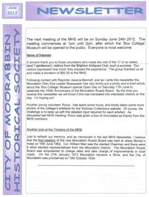
Newsletter - City of Moorabbin Historical Society Apr 2012, April 2012
The City of Moorabbin Historical Society was formed c 1960 by a group of Moorabbin area residents who were concerned that the history of the area should be preserved. A good response to a call for items related to the historical area of Moorabbin Shire brought donations of a wide variety of artefacts which are now preserved by the current members of CMHS at Box Cottage Museum . Helen Stanley, Secretary of CMHS, began producing a Newsletter for members in April 2007 to provide current information and well researched items of historical interestHelen Stanley has produced a bi-monthly Newsletter, 2007 - 2013, for the members of the City of Moorabbin Historical Society that contains well researched interesting historical items, notification of upcoming events, current advice from Royal Australian Historical Society , Museums Australia Victoria and activities of Local Historical Societies. The Newsletter is an important record of the activities of the CMHS. 5 x A4 paper printed on 1 side Issue 26 of the bi-monthly, City of Moorabbin Historical Society Newsletter produced by Society member and Secretary, Mrs Helen Stanley in April 2012. Notice for meeting April 29th , expected visit by Box family descendants 29th, reminder that subscriptions are due, and proposed Open Days June 16th and 17th to celebrate Moorabbin Roads Board 150th Anniversary. The Anvil was delivered from Heathcote on April 17th and it will enhance the Barn display. Helen recalls the story of Private Robert Mitchell, one of the 17 ‘Bentleigh Boys’ who died during World War 1, with 6 photocopied photographs CITY of MOORABBIN HISTORICAL SOCIETY / APRIL 2012 NEWSLETTERcity of moorabbin historical society, stanley helen, melbourne, moorabbin, brighton, cheltenham, ormond, bentleigh, market gardeners, pioneers, early settlers, the moorabbin roads board 1862, city of glen eira, city of kingston, moorabbin shire, parish of moorabbin, brighton east, south brighton, bent tommy, mair william, anvil, blacksmith, mitchell robert, mitchell charles, mitchell catherine, bicycle penny-farthing, bicycle races, smith frank, grocer, centre road bentleigh, foucaucourt france, somme france, world war 1 1914-1918, anzac, -
 City of Moorabbin Historical Society (Operating the Box Cottage Museum)
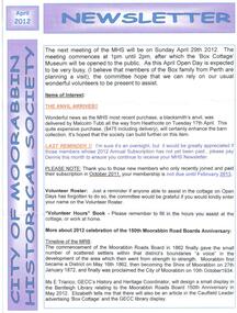
Newsletter - City of Moorabbin Historical Society Aug 2012, August 2012
The City of Moorabbin Historical Society was formed c 1960 by a group of Moorabbin area residents who were concerned that the history of the area should be preserved. A good response to a call for items related to the historical area of Moorabbin Shire brought donations of a wide variety of artefacts that are now preserved by the current members of CMHS at Box Cottage Museum. Helen Stanley, Secretary of CMHS, began producing a Newsletter for members in April 2007 to provide current information and well researched items of historical interestHelen Stanley has produced a bi-monthly Newsletter, 2007 - 2013, for the members of the City of Moorabbin Historical Society that contains well researched interesting historical items, notification of upcoming events, current advice from Royal Australian Historical Society , Museums Australia Victoria and activities of Local Historical Societies. The Newsletter is an important record of the activities of the CMHS1 x A4 paper printed on 1 side Issue 28 of the bi-monthly, City of Moorabbin Historical Society Newsletter produced by Society member and Secretary, Mrs Helen Stanley in August 2012 with photographs of the Ceremony celebrating the 150th Anniversary of the formation of The Moorabbin Roads Board. The Mayors of Glen Eira, Kingston and Brighton unveiled a Plaque at the corner of Cummins Road and Nepean Highway near the original site of the 'Toll gate' . Members of each Historical Society were present including past president of CMHS, His Worship the Mayor of Glen Eira Jamie Hyams. Notes of life at Box Cottagec1918 - 1950 by Stefanie Rennick, nee Reitman, that she donated to CMHS. CITY of MOORABBIN HISTORICAL SOCIETY / AUGUST 2012 NEWSLETTER city of moorabbin historical society, stanley helen, melbourne, moorabbin, brighton, cheltenham, ormond, bentleigh, market gardeners, pioneers, early settlers, the moorabbin roads board 1862, city of glen eira, city of kingston, moorabbin shire, parish of moorabbin, brighton east, south brighton, bent tommy, mair william, jessse morleys hotel, box henry, box william, -
 Whitehorse Historical Society Inc.
Map - Parish Map, Parish of Nunawading, 1892
A map copied from 'Directory maps - parishes and counties' dated 26 Nov 1892. Compiled and lithographed by G.S. Bonney. The map includes roads, railway, stations, names of property owners. It has a scale [ca. 1:31,680] 40 chains to an 1 inch.A map copied from 'Directory maps - parishes and counties' dated 26 Nov 1892. Compiled and lithographed by G.S. Bonney. The map includes roads, railway, stations, names of property owners. It has a scale [ca. 1:31,680] 40 chains to an 1 inch.non-fictionA map copied from 'Directory maps - parishes and counties' dated 26 Nov 1892. Compiled and lithographed by G.S. Bonney. The map includes roads, railway, stations, names of property owners. It has a scale [ca. 1:31,680] 40 chains to an 1 inch.maps, parish of nunawading -
 Narre Warren and District Family History Group
Book, Jean Uhl, Call Back Yesterday - Eumemmerring Parish, 1972
Eumemmerring covers a large area on the south-eastern (Dandenong) perimeter of Melbourne. Jean Uhl traces the development of this once peaceful district into a thriving, modern, industrial zone with its noise, its buildings and its land speculations. Through it we can follow the evolution of Australia from a primary producing company in the nineteenth century to a rapidly expanding industrial nation in the twentieth century. Personalities, buildings and landmarks are presented and discussed with loving care, thus making this book one of the most noteable local histories to be published in recent time in Victoria.xii, 109 p.; 24 cmnon-fictionEumemmerring covers a large area on the south-eastern (Dandenong) perimeter of Melbourne. Jean Uhl traces the development of this once peaceful district into a thriving, modern, industrial zone with its noise, its buildings and its land speculations. Through it we can follow the evolution of Australia from a primary producing company in the nineteenth century to a rapidly expanding industrial nation in the twentieth century. Personalities, buildings and landmarks are presented and discussed with loving care, thus making this book one of the most noteable local histories to be published in recent time in Victoria. eumemmerring (vic.), dandenong (vic.), dandenong (vic.) - history