Showing 2288 items matching "parishes"
-
 Linton and District Historical Society Inc
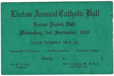
Ticket, Linton Annual Catholic Ball, 1958
Dark green coloured cardboard ticket with black printed text. Ticket is for a ball held at Linton Parish Hall, Wednesday, 3rd September, 1958.Text: " Linton Annual Catholic Ball / Linton Parish Hall / Wednesday, 3rd September, 1958 / DOOR ENTRANCE PRIZE / Gravenall's Orchestra Novelty Dances. "linton annual catholic ball, linton parish hall -
 Whitehorse Historical Society Inc.
Map, Directory Maps of the County of Bourke, 1892
Directory maps of the County of Bourke, containing all the Parishes ...Directory maps of the County of Bourke, containing all the Parishes ... also a complete map of the Colony of Victoria, showing all the Counties, Parishes, Railways and stations to date, and the Mallee Blocks. Lithographed by G.S.B. Bonney for the Victorian Shire Map Company. Scale: 40 chains to the inch.Directory maps of the County of Bourke, containing all the Parishes ...maps, victoria. county of bourke, t.r.b. morton & son -
Whitehorse Historical Society Inc.
Map, Parish of Nunawading, 1939
Plan of subdivision part of crown portions 81, 82 and 89,Plan of subdivision part of crown portions 81, 82 and 89, Parish of Nunawading, County of Bourke, Blackburn Wellington Avenue amended from Stanley RoadPlan of subdivision part of crown portions 81, 82 and 89, street names, parish of nunawading, blackburn road, blackburn, wellington avenue, blackburn, wolseley crescent, blackburn, gordon crescent, blackburn, clarke street, blackburn, central road, blackburn -
 Bacchus Marsh & District Historical Society
Map, Gorrockburkchap Parish Map, County of Grant c.1915
The parish of Gorrockburkchap (sometimes spelled Gorrockburkghap) lies to the west and south west of the township of Bacchus Marsh. The locality of Rowsley is situated within this parish area.A single page paper map showing the parish plan for Gorrockburkchap in the County of Grant. The map is pasted into a bound volume containing 76 maps or plans in total. High resolution digital image stored on BMDHS computer network. gorrockburkchap parish maps, rowsley victoria maps -
 Bacchus Marsh & District Historical Society
Map, Gorrockburkchap Parish Map, County of Grant
The parish of Gorrockburkchap (sometimes spelled Gorrockburkghap) lies to the west and south west of the township of Bacchus Marsh. The locality of Rowsley is situated within this parish area.A single page paper map showing the parish plan for Gorrockburkchap in the County of Grant. The map is pasted into a bound volume containing 76 maps or plans in total. High resolution digital image stored on BMDHS computer network. gorrockburkchap parish maps, rowsley victoria maps -
 Linton and District Historical Society Inc
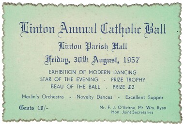
Ticket, Linton Annual Catholic Ball, 1957
Pale green coloured cardboard ticket with blue printed text. Ticket is for a ball held at Linton Parish Hall, Friday, 30th August, 1957.Text: " Linton Annual Catholic Ball / Linton Parish Hall / Friday, 30th August, 1957 / EXHIBITION OF MODERN DANCING / STAR OF THE EVENING / Merlin's Orchestra Novelty Dances. "linton annual catholic ball, linton parish hall -
Surrey Hills Historical Society Collection
Work on paper - Newsletter, Holy Redeemer - St Joseph's Weekly Notice Sheet, c 14 December 1967
In 1901, Fr George Robinson, Parish Priest of Camberwell purchased the present site of Our Holy Redeemer Church, Surrey Hills, which at the time came within the Camberwell Parish. The owner of the land was reluctant to sell to the Catholic Church, but Miss Amy Castles, a noted singer and friend of Fr Robinson, purchased the land in her own name and then transferred it to the church. On 11 May 1902, the Church of the Most Holy Redeemer (the original title of the church) was blessed and opened by Archbishop Thomas Carr, Archbishop of Melbourne. The architect was A. A. Fritsch. The cost was £3,500. In 1904, Fr. Robinson constructed a weatherboard school-hall (later replaced by a brick hall). Archbishop Mannix opened and blessed the new brick school on 10 November 1918. Fr Tim Fitzpatrick was the third parish priest and served from 1941-1972. A slightly yellowed foolscap sheet printed on both sides detailing the activities of the Surrey Hills parish around Easter in April 1972.st joseph's convent, holy redeemer, catholic church, fr tim fitzpatrick, fr n mackay, b mcdonald, j moloney, k lourey, r kennedy, francis baker, mary gertrude mier, veronica fitton, dorothy erwin, terry young, carmel young, junior youth club, joan murphy, mr hurley, mrs kit o'neil, pat galletti, mothers' club, ed curmi, peter burns, angela lamaro, mary owen, helen buckley, p heffernan, n griffith, g mooney, a dignam, e rankin, d mooney, sister margarida -
 Bacchus Marsh & District Historical Society
Map, Parish of Yangardook, County of Bourke 1876
The parish of Yangardook lies directly north of the township of Melton. The locality of Toolern Vale lies in the centre of this parish. A single page paper map showing the plan for the Parish of Yangardook in the in the County of Bourke. Scale 40 chains to 1 inch. The map is pasted into a bound volume containing 76 maps or plans in total. High resolution digital image stored on BMDHS computer network. Photo lithographed at the Department of Lands and Survey, Melbourne by J. Noone, 1.8.76yangardook parish maps, toolern vale victoria maps -
 Linton and District Historical Society Inc
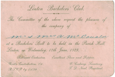
Card - Invitation, Linton Bachelors' Club, 1929
Cream coloured card with gold embossed text. Invitation to Linton Bachelors' Club Ball held at Linton Parish Hall on June 12th, 1929.Text: ' Linton Bachelors' Club / The Committee of the above request the pleasure of / the company of / Mr. & Mrs. A McDonald / at a Bachelor's Ball to be held in the Parish Hall, Linton; on Wednesday, 12th June, 1929. 'linton bachelors' club, dances, entertainment -
Clunes Museum
Certificate - CERTIFICATE WITH SEAL, 1928
REVEREND FRANK GIRDLER APPOINTED TO THE PARISH OF CLUNES, APPOINTED TO REPLACE PREVIOUS INCUMBENT BY RESIGNATION, WILLIAM AUGUSTE WILSON 15/8/1928A CERTIFICATE APPOINTING THE REV. FRANK GIRDLER TO THE PARISH OF CLUNES, DATED 15TH AUGUST, 1928, WITH SEAL FROM THE BISHOP OF BALLARAT ,PHILIP CHARLES THURLOWVICAR OF CLUNES REVEREND F. GIRDLER, AUGUST 15TH 1928 - 33local history, certificates, st-pauls anglican -
Tatura Irrigation & Wartime Camps Museum
Book, A History of the Sacred Heart Parish of Tatura, 1989
Book prepared in association with Centenary Celebrations of the Sacred Heart Parish, Tatura, in 1989.Soft glossy cover, yellow and grey. A History of the Sacred Heart Parish of Tatura and 1889 - 1989 on front. Photograph of sacred heart church, Tatura on front. Book includes a number of photographs. Present to Tatura Museum by Margaret Normington, November 1989sacred heart church tatura, centenary celebrations -
Glenelg Shire Council Cultural Collection
Postcard, H.A. George, CHRIST CHURCH CASTERTON, Christ Church Parish Hall, n.d
Sourced from Casterton Town Hall (former Shire of Glenelg)Postcard, black and white. Two images. Upper ' Christ Church Casterton'; lower 'Christ Church Parish Hall'Front: 'Christ Church Casterton H.A. George, photo' in border unDer top image 'Christ Church Parish Hall' bottom left corner of lower image Back: Green stamp 'F. Henty Silvester 'Girrahween', Merino, Vic.' -
 Kiewa Valley Historical Society
Parish Maps - Kiewa Valley
The Parish Maps show how the Counties were divided into allotments for buyers. On one the original owners are named and the sizes of their properties given. The reference numbers enable individuals research the history of the property. The other is on a smaller scale giving only the allotment numbers. The map with the names gives information on the early settlers of the Kiewa Valley. They show how the Kiewa Valley was divided up into allotments for town dwellers and farmers and enables further research.Two copies of Parish Maps of the towns in the Kiewa Valley. One gives the original owners and the other the reference numbers of the allotments.kiewa valley. parish maps. land owners -
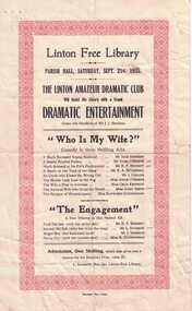 Linton and District Historical Society Inc
Programme, "Standard" Typ., Linton, The Linton Amateur Dramatic Club, 1935, 1935
Advertises the Linton Amateur Dramatic Club night of "dramatic entertainment", to be held in the Parish Hall on September 21st 1935 to raise funds for the Linton Free Library.Cream sheet with 1cm decorative red border.Text: " Linton Free Library / PARISH HALL, SATURDAY, SEPT. 21st, 1935 / THE LINTON AMATEUR DRAMATIC CLUB / Will Assist the Library with a Grand / DRAMATIC ENTERTAINMENT. "linton amateur dramatic club, programmes, jack sheehan, clem o'beirne, h. p. bennett, h.a. mccorkell, j. collins, annie o'beirne, celia kennedy, daisy smith, kath cunningham, lionel sparrow -
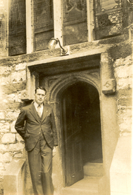 Federation University Historical Collection
Photograph - Black and White, Frank Wright, St Andrew's Plymouth, 1934, 19/6/34
Frank Wright was a renown resident of Smeaton, where he was born. He lived at Laura Villa, and attended Smeaton State School. His father William was a gold miner and his mother's name was Sarah. Their family won many singing and instrumental awards. Frank was tutored by Percy Code and was awarded a gold medal for the highest marks in the ALCM examinations in the British Colonies at the age of seventeen years. He became the Australian Open Cornet Champion by the age of eighteen. A year later, Frank conducted the City of Ballarat Band, and later the Ballarat Soldiers’ Memorial Band. He formed the Frank Wright Frisco Band and Frank Wright and his Coliseum Orchestra. These bands won many South Street awards, and Frank as conductor won many awards in the Australian Band Championship contest. In 1933 Frank Wright sailed to England to conduct the famous St Hilda’s Band and was later appointed Musical Director of the London County Council, where he organized many amazing concerts in parks, in and around the London district. He was made Professor of Brass and Military Band Scoring and conducted at the Guildhall of Music and Drama. Frank was often invited to adjudicate Brass Band Championships around Europe, in Australia, including South Street and in New Zealand. The Frank Wright Medal at the Royal South Street competition is awarded to an individual recognized as making an outstanding contribution to brass music in Australia.Black and white photograph of a man dressed in a suit standing leaning against the entrance surround of an ornate stone door of a church. Above the door is the lower part of a four sectioned stained glass window. The man is Frank Wright and the place is St. Andrew's Parish Church in Plymouth.Written in pencil on the back - Frank Wright 32, outside St Andrew's Parish Church (13th Century), Plymouth 19-6-34frank wright, conductor, st andrew's parish church, plymouth, church door -
 Whitehorse Historical Society Inc.
Map - Parish Map, Parish of Nunawading, 1892
A map copied from 'Directory maps - parishes and counties' dated 26 Nov 1892. Compiled and lithographed by G.S. Bonney. The map includes roads, railway, stations, names of property owners. It has a scale [ca. 1:31,680] 40 chains to an 1 inch.A map copied from 'Directory maps - parishes and counties' dated 26 Nov 1892. Compiled and lithographed by G.S. Bonney. The map includes roads, railway, stations, names of property owners. It has a scale [ca. 1:31,680] 40 chains to an 1 inch.non-fictionA map copied from 'Directory maps - parishes and counties' dated 26 Nov 1892. Compiled and lithographed by G.S. Bonney. The map includes roads, railway, stations, names of property owners. It has a scale [ca. 1:31,680] 40 chains to an 1 inch.maps, parish of nunawading -
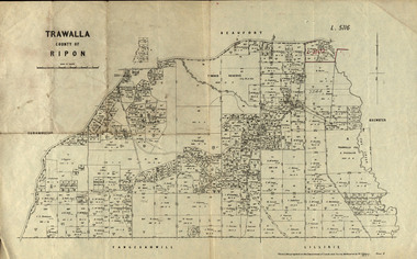 Federation University Historical Collection
Parish Plan, Parish Plan of Trawalla in the Parish of Rippon, 1913, 28/4/1913
Trawalla is surrounded by Beaufort, Brewster, Lillirie, Yangerahwill and Eurambee.Parish Plan of Trawalla in the Parish of Rippon. trawala, ripon, westbrok, simson, mackenzie, mcarthur, wilson, nicholason, gibb, read, hayward, topper, foreman, bell, mcmillan, halpin, davis, goldsmith, trawalla pre-emptive right, butson, w.j. butson, m4471, w. read, c.a. foreman, j. simson, a. goldsmith, trawalla, g. topper -
City of Moorabbin Historical Society (Operating the Box Cottage Museum)
Book - The Living Harvest - A history of St. Peter's Parish, East Bentleigh, by W. T. Dobson, 1974
The first building that was erected in the Parish of St Peter's was a little wooden school house, built by local market gardeners in February 1865. The school was demolished and a brick school building was erected and opened in1903. St Peter's School, East Bentleigh was erected by the many Irish Market Gardeners of Moorrabin in 1865 and was integral to the education, spiritual well being and social life of the early settlers.A book on the history of St Peter's Parish, Centre Road, East Bentleigh, with pictures. 57 pages. Contains local history, history of early pioneer families, St Peter's School and the church.early settlers, parish of moorabbin, city of moorabbin, county of bourke, shire of moorabbin, market gardeners, center road, irish settlers, east bentleigh, st peter's church east bentleigh, religion, catholic -
 Bacchus Marsh & District Historical Society
Map, Coimadai Parish Map, County of Bourke. Circa 1890s-1900s
The cadastral Parish of Coimadai, a subdivision of the County of Bourke, lies directly north of the township of Bacchus Marsh. The date of this map is uncertain. T.F. McGauran the person who made a photo-lithographic copy of the map was in charge of photo-lithography at the Victorian Department of Lands and Survey in the late 19th century until about 1910.A single page paper map showing the map for the Parish of Coimadai in the County of Bourke. A cadastral map showing parish boundaries and land ownership. A rectangle shaped area is missing from the centre of the map due to a tear or deliberate excision. The map is pasted into a bound volume containing 76 maps or plans in total. High resolution digital image stored on BMDHS computer network. Photo-lithographed at the Department of Lands and Survey, Melbourne by T.F. McGauran 26.8.[??] NOTE. Photo litho from L.P showing temporary surveys and occupation of land prepared for departmental use onlybacchus marsh region parish plans, coimadai parish maps, coimadai parish plan -
Moorabbin Air Museum
Document (item) - Fatigue Test Results And Analysis Of 42 Piston Provost Wings
By H.E. Parish A.F.R.Ae.S. -
 Uniting Church Archives - Synod of Victoria
Photograph - B&W Photograph, Moyston Uniting Church
Moyston: Ararat Parishmoyston presbyterian church, moyston uniting church -
Clunes Museum
Container - ENGRAVING & BOX
INFORMATION ON BOX LID-THE ENCLOSED IMPRESSION EXHIBITS A LIKENESS OF THE REV. JOHN WESLEY, ENGRAVED ON A FOSSIL ECHINUS, OR SEA-EGG, IN THE POSSESSION OF MR. JOHN HEY OF LONDON. THE CLEVER ARTIST WHOSE WORK IT IS, PRONOUNCED THE STONE TO BE HARDEST HE HAD EVER ENGRAVED.A LIKENESS OF THE REV. JOHN WESLEY, ENGRAVED ON A FOSSIL ECHINUS, OR SEA-EGG. IN A SMALL BOX"THE WORLD IS MY PARISH"engraving, wesley, rev john wesley -
 Bayside Gallery - Bayside City Council Art & Heritage Collection
Map, Department of Crown Lands and Survey et al, Moorabbin, County of Bourke, Government Roads, 1920
The cadastral map of the Parish of Moorabbin in Victoria (L.6104) shows parish boundaries and land ownership 1920 when Sandringham was a Town. The government roads have been coloured in red pencil.moorabbin, county of bourke, map, plan, land subdivision, land titles, foreshores, hampton, beaumaris, highett, cheltenham, department of lands and survey, land owners, cartographic material, brighton, sandringham, town of sandringham, government roads -
 Bendigo Historical Society Inc.
Map - JACK FLYNN COLLECTION: SALISBURY, 1965
Map: Parish of Salisbury, County of Bendigo. Parish plan.By Authority A. C. Brooks Government Printer, Melbourne. Drawn and Reproduced at the Department of Lands and Survey, Melbourne.map, bendigo, parish plan, salisbury -
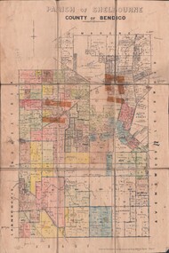 Bendigo Historical Society Inc.
Map - JACK FLYNN COLLECTION: SHELBOURNE, 11/02/1937
Map: Parish of Shelbourne, County of Bendigo. Parish plan.By Authority, H. J.Green, Government Printer. Drawn and Reproduced at the Dept, of Lands and Survey, Melbourne, Victoria.map, bendigo, parish plan, shelbourne -
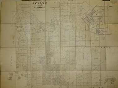 Bendigo Historical Society Inc.
Map - JACK FLYNN COLLECTION: RATHSCAR, 14/09/1935
Map: Parish of Rathscar, County of Gladstone. Parish plan.map, gladstone, parish plan, rathscar -
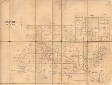 Bendigo Historical Society Inc.
Map - JACK FLYNN COLLECTION: RUNNYMEDE, June 1946
Map: Parish of Runnymede, County of Rodney. Parish plan.By Authority: J.J. Goourley, Government Printer, Melbourne. Drawn and Reproduced at the Lands and Servey, Melbourne, Victoria. June, 1946.map, rodney, parish plan, runnymede -
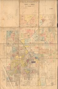 Bendigo Historical Society Inc.
Map - JACK FLYNN COLLECTION: NEILBOROUGH, 13/10/1927
Map: Parish of Neilborough, County of Bendigo. Parish plan.Photo Lithographed at the Department of Lands and Survey, Melbourne by W.J. Butsonmap, bendigo, parish plan, neilborough -
 Bendigo Historical Society Inc.
Map - JACK FLYNN COLLECTION: MUSKERRY, 1962
Map: Parish of Muskerry, County of Rodney. Parish plan.By Authority: A.C. Brooks, Government Printer, Melbourne. Drawn and reproduced at the Department of Lands and Survey, Melbournemap, rodney, parish plan, muskerry -
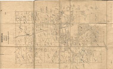 Bendigo Historical Society Inc.
Map - JACK FLYNN COLLECTION: MOORA, 9/10/22
Map: Parish of Moora, County of Rodney. Parish plan.By Authority A.J. Mullet Government Printer Melbourne. Photo Lithographed at the Dept, of Lands and Survey, Melbourne by W.J. Butson. 3.10.22map, rodney, parish plan, moora