Showing 4583 items matching "park street"
-
 Bendigo Military Museum
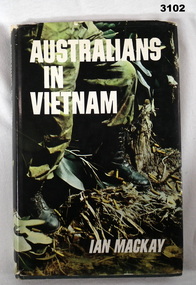
Book - BOOK, VIETNAM, Ian Mackay, Australians in Vietnam, 1968
... Prince of Wales Lighthorse Bougainville Barracks Park Street... Barracks Park Street North Carlton” Paper dust cover in colour ...A complete story covering the experiences of Australian men & women during the Vietnam campaign.Paper dust cover in colour, title on front & spine. Hard green buckram cover with title & author on spine. On fly leaf is a map of Vietnam & jungle scene with 2 soldiers in green colour. 201 pages, cut edges, white with black print & black & white photos. Stamp on top right hand side of title page: “RHQ 4/19 Prince of Wales Lighthorse Bougainville Barracks Park Street North Carlton” books-military-history, photography, vietnam -
 Williamstown Historical Society Inc
Photograph - Lyons Street, Williamstown
... Lyons Street - Park House - Sketch... Park House Presbyterian Manse Lyons Street - Park House ...Originally the Presbyterian Manse Lyons Street - Park House - Sketchlyons street, williamstown, park house, presbyterian manse -
 Eltham District Historical Society Inc
Photograph, Liz Pidgeon, EDHS Heritage Walk: Shillinglaw Farm, Eltham, 2 September 2023
... Amplifon Andrew Park Andrew Pocket Park Arthur Street Bar de Tapas ...On Saturday September 2, 2023, Russell Yeoman led a group of 22 society members and interested others on a walk following trhe bounadries of the original Shillingalw farm. Commencing at the corner of Panther Place and Library Place, we proceeded up to Shillinglaw Cafe then the Shillinglaw trees at the former Eltham Shire Office site then along Main Road to the fire station then throughh St Laurence Lane and uinder the railway line , along Diamond Street then return via the Diamond Creek trail behind Andrew Park. The actual farm boundary went past the creek and further up the hill. The original farm comprised lot 90 of Holloway’s 1851 subdivision of Little Eltham. Its area was 30 acres lying east of the Diamond Creek and north of Henry Street. A number of stops were made to look at maps and early photos illustrating the gradual reduction of the farm area and the early history of the railway and other community uses, that occupied parts of the site.2023-09-02, activities, eltham, eltham district historical society, heritage excursion, shillinglaw farm, 895 main road, amplifon, andrew park, andrew pocket park, arthur street, bar de tapas, barber shop, barry plant estate agent, blockbuster, bus depot, car park, carparks, central park, cleaver & co hair, commonwealth bank, crust pizza, divine bridal, dr ash constance, dudley street, eltham book shop, eltham convenience store, eltham fire station, eltham library, eltham newsagency, eltham optical, eltham railway station, eltham shops, fay bridge, fire bell, flagpole, flight centre, grill'd, information sign, iso chook, jellis craig estate agent, judge book village, kebab nation, kx pilates, la zanyas, liquorland, little drop of poison, lorraine jones & associates solicitors, luck street, machan indian restaurant, main road, mecho en mexico, missing gorilla, morrison kleeman real estate, pavilion menswear, platform 3095, playtherapy melbourne, pryor street, ray white real estate, restaurants, sage bulk whole foods, shillinglaw trees, sign, snap fitness, southern cross medical imaging, specsavers, st laurence lane, st vincents care service, thompson's pharmacy, todaro, united service station, vyve body & skin, welcome to eltham town, westpac bank, yang's kitchen, youth road -
 Eltham District Historical Society Inc
Photograph - Aerial Photograph, Landata, Eltham, Feb. 1956
... Street, Eltham bounded by Luck Street to north, Eltham Lower Park ...Centred on present day Mount Plaeasant Road near Dalton Street, Eltham bounded by Luck Street to north, Eltham Lower Park to south, Reynolds Road to east and Central Park to west Historic Aerial Imagery Source: Landata.vic.gov.au Aerial Photo Details: Project No :250 Project : MELBOURNE OUTER SUBURBS PROJECT Run : 18 Frame : 93 Date : 02/1956 Film Type : B/W Camera : EAG9 Flying Height : 10000 Scale : 12000 Film Number : 1176 GDA2020 : 37°43'02"S, 145°09'38"E MGA2020 : 337871, 5823961 (55) Melways : 22 B6 (ed. 42)aerial photo, 1956-02, neil webster collection, eltham, central park, eltham lower park, luck street, melway 22b6, nyora road, reynolds road, dalton street, mount pleasant road -
 Eltham District Historical Society Inc
Postcard - Photograph postcard, Panorama at Eltham, Vic, c.1923
... Diamond Street, present-day Andrew Park to the railway station... Diamond Street, present-day Andrew Park to the railway station ...The Rose Series P. 4284 post card Taken from near what would be present day CLC car park looking southwest across Diamond Street, present-day Andrew Park to the railway station and developing Eltham shopping precinct. Arthur Street visible, Pryor and Luck Street not evident. Sunnybrook, the Taylor home is visible at the top of the hill in Bible Street. Only three residences visible in Arthur Street on the southern side, two of these are the David Harbison Rest Home at 10 and 12 Arthur Street (built and opened in November 1919), present day site of Eltham Mall. There are none on the north side of the street. Based on 1945 aerial view there are 8 buildings on the northern side between Main Road and Bible Street which and given the extent of commercial development on Main Road, it is estimated this image is circa 1925. Luther Haley was the first to build an open a baker and General Store in this location next to the railway station in 1902. However, it took nearly twenty years until the early to mid-1920s when a period of significant growth in the Eltham shopping centre happened with many businesses relocating their operations from the original town centre of Maria Street in Little Eltham as well as new businesses opening. Other stores/buildings noted (L-R) are: Stationmaster's House built circa 1910 Eltham Hardware Store opposite the railway station first opened on Main Road opposite the Railway Station around late 1922. An advertisement placed in the Hurstbridge Advertiser advised that the Hardware Store had just opened with a varied stock of Saws, Hammers, Nails, Shovels, Screw Drivers, and every article required in a house or on a farm. People were also encouraged to try their Jams, Pickles, Sauces, Cups and Saucers, etc. Newsagency with 'Leader' advertising on awning - E. J. Andrew opened his newsagency shop opposite the station in March 1923, advertising for sale stationery, school requisites and periodicals. Bird Brothers Cash Grocer & Fruiterer opposite the railway station offering summer drinks and confectionery a specialty with a full Stock of groceries of the best quality always on hand at city prices opened December 1921 William Capewell's Butcher shop at the corner of Dudley Street. Capewell previously had a small shop in front of the station opposite Luck Street. He enlisted in the AIF during WW1 and returned home in 1919. He re-applied for a slaughtering license in February 1920 and was advertising by October 1922 supplying all districts. Not visible (or not yet identified) but in business by October 1922 were: J.H. Fraser, Carpenter and Builder at Luck Street opposite the station George A. Danslow, Hairdresser and Tobacconist opposite the railway station Miss Barber's 'Blue Gum' Soda Fountain opened October 1922 opposite the railway station (hidden behind Stationmaster's House). It was so named due to its proximity to a tall Blue Gum tree G.H. McDonald Boot Repairer opposite the railway station In December 1923 the first portion of the main street to be formed from Dudley to Arthur streets was almost completed. This is the section in front of Capewell's Butcher shop though it is difficult to fully make out from the photoDigital file only Postcards scanned from the collection of Michael Aitken on loan to EDHS, 2 Sep. 2022michael aitken collection, eltham, postcards, arthur street, david harbison rest home, electrine candles, eltham railway station, eltham shopping centre, lloyd's general store, red rattler, rose series postcard, rose stereograph company, tait train, velvet soap, andrew park, bible street, bird brothers cash grocer & fruiterer, bird brothers cash grocer and fruiterer, butcher, diamond street, dudley street, eltham hardware and timber, eltham hardware store, eltham mall, main road, station masters house, stationmaster's house, sunnybrook, w.j. capewell, w.j. capewell butcher shop -
 Eltham District Historical Society Inc
Photograph - Colour Print, Alistair Knox Park, Eltham, Victoria, Australia, c.1990
... melbourne Alistair Knox Park Bridge Street Bridge Street Bridge ...alistair knox park, bridge street, bridge street bridge, eltham -
 Eltham District Historical Society Inc
Photograph - Aerial Photograph, Intersection of Main Road and Bridge Street, c.1995
... Alistair Knox Park Bridge Street Brougham Street Central Park ...View of Main Road from Henry Street to Brougham Street across to the Diamond Creek showing the Eltham Shire Offices (demolished 1996), the Eltham Library (opened 1994)aerial photo, alistair knox park, bridge street, brougham street, central park, diamond creek (creek), eltham, eltham community centre, eltham courthouse, eltham justice precinct, eltham living and learning, franklin street, henry street, local history centre, main road -
 Eltham District Historical Society Inc
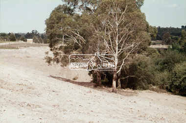
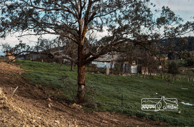
Photograph - Colour Print, Lewis Tulk, Eltham District Scout Camp, Eltham Town Park, c.1982
... Park Bridge Street Digital file only of colour print loaned ...Bridge Street in background. Donated by Lewis Tulk, former Scout Area Training Commisioner for Leaders.scouts victoria, scout leader training, lewis tulk collection, yarra batman area, alistair knox park, eltham district scout camp, eltham town park, bridge street -
 Eltham District Historical Society Inc
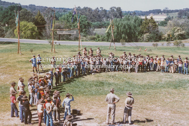
Photograph, ELTHAM ARBOR DAY 1973 - Alistair Knox with school children of the Shire of Eltham, Vic, planting native trees in the Town Park, 10 October 1973, 1973-10-10
... town park bridge street Black and white photograph ELTHAM ARBOR ...ELTHAM - ARBOR DAY, 10 Oct 1973. School children of the Shire of Eltham planting trees (previously planned to take place during the visit of Sir Rohan Delacombe to the Shire on 19th September, 1973 but cancelled that day due to inclement weather). REF: 783 SOURCE: Shire of Eltham (Eltham District Historical Society) Eltham Town Park would later be renamed Alistair Knox ParkBlack and white photographeltham, arbor day, alistair knox, alistair knox park, eltham town park, bridge street -
 Eltham District Historical Society Inc
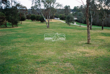
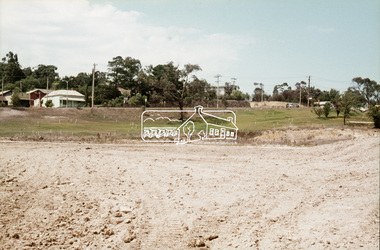
Slide, Construction of Eltham Town Park, 22 Feb 1974
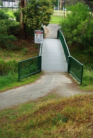
... bridge. alistair knox park eltham town park Bridge Street bridge ...Construction of Eltham Town Park, later renamed Alistair Knox Park. In the foreground is where the Diamond Creek Trail runs along the creek and in the distance is the Bridge Street bridge.35 mm colour positive transparency Mount - Agfacolor Service (Blue)alistair knox park, eltham town park, bridge street bridge -
 Eltham District Historical Society Inc
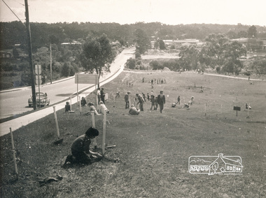
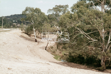
Slide, Construction of Eltham Town Park, 22 Feb 1974
... planted. alistair knox park eltham town park Bridge Street Main ...Construction of Eltham Town Park, later renamed Alistair Knox Park. View looking towards the intersection of Main Road and Bridge Street. The lake body has been formed and young trees planted.35 mm colour positive transparency Mount - Agfacolor Service (Blue)alistair knox park, eltham town park, bridge street, main road -
 Eltham District Historical Society Inc
Slide, Construction of Eltham Town Park, 22 Feb 1974
... Knox Park. View looking towards Bridge Street and shows ...Construction of Eltham Town Park, later renamed Alistair Knox Park. View looking towards Bridge Street and shows the Diamond Creek and formation of the Diamond Creek Trail.35 mm colour positive transparency Mount - Agfacolor Service (Blue)alistair knox park, eltham town park, bridge street bridge, diamond creek -
 Marysville & District Historical Society
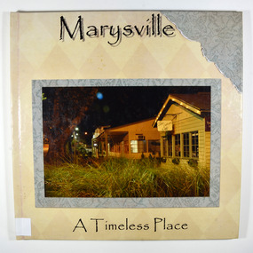
Book - Hardback, Marysville-A Timeless Place
... darmody lake galipolli park murchison street meeting of the waters ...A pictorial journey of Marysville before the 2009 Black Saturday bushfireA book of photographs taken in and around Marysville before the 2009 Black Saturday bushfires. Marysville was almost completely destroyed in the fire and this book showcases natural attractions, locations to eat and stay and some of the local flora and fauna in and around the district.Hardcover. Front cover has a photograph of the Corner Cupboard Cafe in Marysville taken at night.In memory of those that lost their lives and property in the/ Black Saturday fires/ on the 7TH of G=February 2009marysville, photographs, victoria, australia, black saturday, bushfire, 2009, 7th february 2009, angelina lodge, darmody lake, galipolli park, murchison street, meeting of the waters, marysville bakery, marysville patisserie, lolly shop, bruno's sculpture garden, crystal journey, flora, fauna, coralyn falls, steavenson falls, keppel lookout -
 Marysville & District Historical Society
Document (Item) - Information document, Victorian Bushfire Reconstruction and Recovery Authority, Marysville Heart Project, 2010
... Marysville & District Historical Society 39 Darwin Street ...A document outlining the re-building and re-development of Marysville in Victoria.A document outlining the re-building and re-development of Marysville in Victoria.marysville, victoria, 2009 black saturday bushfires, marysville and triangle urban design framework, gallipoli park, murchison street, marysville community centre -
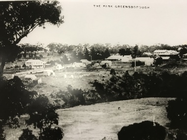 Greensborough Historical Society
Photograph, The Park Greensborough, 1900c
... Plenty Lower Plenty melbourne View of Greensborough Park from ...View of Greensborough Park from Partington's Hill, showing sporting ground, Plenty River, Marble Hall, sparse housing on north side of Main Road, the Farmers' Arms hotel, the Rechabite Hall and Main Road bridge over the the railway line. Marble Hall is the double-storied building on the corner of Main Road.Part of a collection of 5 enlarged photographs dating from the early 1900s.Black and white enlargement of photographgreensborough park, main street greensborough, rechabite hall, farmers' arms hotel, marble hall, greensborough railway -
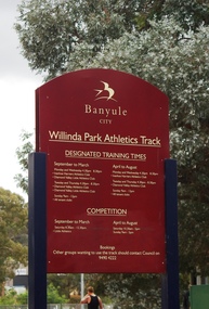 Greensborough Historical Society
Photograph - Digital Image, Marilyn Smith, Willinda Park Sign, 06/11/2017
... Council sign at the park. willinda park beatrix street ...Willinda Park is situated in Beatrix Street Greensborough. It has an athletics track and field and is adjacent to the Plenty River. This photograph shows the Banyule Council sign at the park.Digital copy of colour photographwillinda park, beatrix street greensborough, athletics -
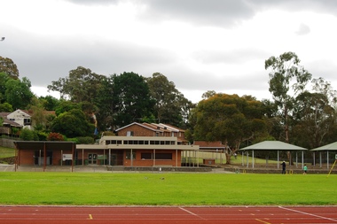 Greensborough Historical Society
Photograph - Digital Image, Marilyn Smith, Willinda Park Buildings and facilities, 06/11/2017
... of the facilities at the park. willinda park beatrix street greensborough ...Willinda Park is situated in Beatrix Street Greensborough. It has an athletics track and field and is adjacent to the Plenty River. These photographs show some of the facilities at the park.Digital copy of colour photographwillinda park, beatrix street greensborough, athletics -
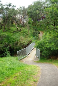 Greensborough Historical Society
Photograph - Digital Image, Marilyn Smith, Willinda Park bridge to George Court, 06/11/2017
... Plenty Lower Plenty melbourne Willinda Park is situated ...Willinda Park is situated in Beatrix Street Greensborough. It has an athletics track and field and is adjacent to the Plenty River. This photograph shows the footbridge across the Plenty River to George Court.Digital copy of colour photographwillinda park, beatrix street greensborough, athletics, plenty river -
 Greensborough Historical Society
Photograph - Digital Image, Marilyn Smith, Willinda Park bridge to Simms Road, 06/11/2017
... Plenty Lower Plenty melbourne Willinda Park is situated ...Willinda Park is situated in Beatrix Street Greensborough. It has an athletics track and field and is adjacent to the Plenty River. This photograph shows the footbridge across the Plenty River to Simms Road Reserve.Digital copy of colour photographwillinda park, beatrix street greensborough, athletics, plenty river -
 Greensborough Historical Society
Photograph - Digital Image, Marilyn Smith, Plenty River near Willinda Park, 06/11/2017
... . willinda park beatrix street greensborough athletics plenty river ...This group of photographs shows the Plenty River adjacent to Willinda Park. Willinda Park is situated in Beatrix Street Greensborough and has an athletics track and field. Digital copy of colour photographswillinda park, beatrix street greensborough, athletics, plenty river -
 Greensborough Historical Society
Photograph - Digital Image, Marilyn Smith, Log over the Plenty River near Willinda Park, 06/11/2017
... . willinda park beatrix street greensborough athletics plenty river ...This photograph shows a log over the Plenty River adjacent to Willinda Park. Willinda Park is situated in Beatrix Street Greensborough and has an athletics track and field. Digital copy of colour photographwillinda park, beatrix street greensborough, athletics, plenty river -
 Eltham District Historical Society Inc
Photograph, Russell Yeoman, 66 Susan Street, Eltham, c.1965, 1965c
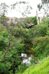
... is part of the Alistair Knox Park. eltham streets houses alistair ...Bridge Street on left. In 1965 the property was owned by the Shire of Eltham. 66 Susan Street was eventually developed into the Eltham Skate Park in the 1990s and the rest of the property is part of the Alistair Knox Park.Digital file only; created from original colour positive slide transparencyeltham, streets, houses, alistair knox park, eltham skate park, susan street, russell yeoman collection, bridge street -
 Eltham District Historical Society Inc
Photograph, Russell Yeoman, 66 Susan Street, Eltham, c.1965, 1965c
... under washing. eltham streets susan street eltham skate park ...Looking southeast from backyard, Bridge Street visible under washing.Digital file only; created from original colour positive slide transparencyeltham, streets, susan street, eltham skate park, alistair knox park, bridge street, russell yeoman collection -
 Eltham District Historical Society Inc
Photograph, Fred Mitchell, Site of the new Eltham Town Park, corner of Main Road and Bridge Street, Eltham, 1968, 1968
... Street Eltham Town Park Digital copy of colour photograph Site ...During the Main Road duplication. Bridge Street in background to the right of picture. Eltham Town Park was later renamed Alistair Knox Park.Digital copy of colour photographfred mitchell collection, 1968, main road, road construction, duplication, alistair knox park, bridge street, eltham town park -
Glen Eira Historical Society
Article - Rosstown Railway
... Carnegie Riddell Parade Clarence Street Aileen Avenue Princes Park ...This file contains three items: 1/A review of the ROSSTOWN RAIL TRAIL from LIVING IN GLEN EIRA, vol. 11, 2004, Issue 4, no. 25, date and author unknown. The review explains the purpose of the Rail Trail with a brief narrative of the history behind Rosstown Sugar Mill Railway line. Concluding with information on the location of the Trail and the expected time required to walk the entire track included in the review is a map of the Rail Trail, which marks significant sites along the trail with historic pictures. 2/A newspaper article from THE AGE, dated Tuesday 21/10/1980 and written by Iola Matthews, reporting on the circumstances that led to the publication of the book RETURN TO ROSSTOWN written by Des Jowett and Ian Weickhardt. The article begins with a brief biography of the authors before moving into details of the book’s content, providing a further biography of W. Murray Ross which includes information on his financial ventures – particularly the Rosstown Rail – his marriage and children. The article includes a black and white photograph of Weickhardt and Jowett walking along the route of the railway line, an illustration of the Rosstown sugar works and a map of the area surrounding the site of the mill. 3/Three photocopies of a black and white illustration of the Rosstown sugar works from the east, undated and artist unknown.rosstown rail trail, rosstown, ross william, ross w. murray, ross murray, sugar beet mills, mills, elsternwick, land transport, railways, railway lines, railway routes, carnegie neville street, carnegie miller street, factories, market gardens, horticulture, peat, soils, land forms, topography, geology, civic issues, cone sugar industry, elsternwick plaza, elsternwick, glenhuntly road, parks and reserves, ee gunn reserve, caulfield racecourse, sportsgrounds, caulfield, carnegie, riddell parade, clarence street, aileen avenue, princes park, dover street, marara road, oakleigh road, rosanna street, murrumbeena crescent, north road, kooyong road, hawthorn road, booran road, koornang road, poath road, warragul road, railway platforms, railway buildings, bambra road, swamps, landforms, landfill, council landfill, railway bridges, bridges, railway underpasses, sporting clubs, tennis clubs, bowls clubs, rosstown railway, rosanna street reserve, maps, railway maps, living in glen eira, weickhardt ian, jowett des, caulfield south, curraweena road, oakleigh, caulfield technical school, return to rosstown, beet sugar industry, crops, land booms, land development and subdivisions, bent thomas, fink benjamin, sugar works, rosstown hotel, oamdenong road, rosstown dry cleaners, shops, rosstown road, rosstown plate, people by circumstance, migrants, accountants, occupations, professionals, the grange, real estate, grange road, financial agents, judges, rosstown estate, financial trouble, rabbit preserving, breweries, political debates, political issues, political electorates, politics, political science, debt, financial loans, court procedures, court cases, legal events and activities, malleson and riggall, widowers, seabeach railway, economics, economic deadline, depression 1890s, economic crash, mortgages, divorce, social problems, poverty, ross claude, ross roderick, world war 1914-1918, wars, military history, servicemen, australian flying corps, engineers, caulfield council, swagmen, homelessness, glenhuntly road, glenhuntly road tram, woornack road, leila road, wild cherry road, melten avenue, illustrations, steam trains, trains, horse and cart, horse-drawn transport, railway stations -
Glen Eira Historical Society
Document - CAULFIELD CITIZENS ADVICE BUREAU
... Hostels Elsternwick Caulfield Festival Caulfield Park Maple Street ...This file contains 2 items: 1/Original copy of 17th Annual Report of city of Caulfield Citizens Advice Bureau September 1987. Report includes Agenda for the Annual General Meeting held at City Hall on Wednesday 30091987, list of office bearers, minutes of the previous AGM, election of Management Committee and presentation of Life memberships plus list of Legal Advice Service solicitors. 2/Original copy of Agenda and 25th Annual Report for Caulfield Citizens Advice Bureau Incorporated presented to the Annual General meeting on 30/08/1995 at Caulfield City Hall. Report includes financial statement F Y E 30/06/1995, details of President’s Report, minutes of previous AGM in 1994.caulfield, citizen’ advice bureau, meetings, caulfield city hall, annual report, grants, edwards mavis, hocking john, green carol, coad thelma, harry carol, hession dorothy, lambert sam, moorrees joyce, ravenscroft jean, rowland dorothy, tyrell audrey, snowball betty, telford nancy, jelleff jenny, kay yvonne, bannister jean, fooks john, allsop doris, bullivant trudy, capek irene, carr fred, cairncross gwen, gorden peg, daniels maurice, davey dulcie, gresham greta, gresham john, hicks margaret, hind lillian, jacombs ken, joseph marion, kinross jo, lukies arthur, lukies noela, mander clive, miles glad, moser ellen, popper irene, poynton ray, splatt betty, stewart may, telford nancy, wray shirley, watson beth, chapman john, felder ilse, helman anne, mccarthy marie, richardson elizabeth, steward derek, williams marcia, blacher rosa, heyman manfred, tanner ted mla, dunstan don. cr, martens veronika cr, legge mary, crossley rosemary, malvern citizens’ advice bureau, deal communication centre, child joan mp, macphee ian hon mp, shipton roger mp, mccutcheon andrew mla, campbell jack, mayor, mayoress, campbell mrs., rudzki brian cr, milne sandy, fusion, moyle gwen, westlake margaret, gild anne, herszfeld henry, lee alf, lee rae, peters leanie, pratt lillian, trumble joan, wise john, nicholls harry, grist molly, payne ruth, victorian association of citizens’ advice bureaus, emergency relief funds, community buses, sinisgalli john, aroni beni, chisholm john, erlichster george, folkers herman, jackson ross, kraus michael, lewis ray, oliver michael, romer andrew, simons adrian, smith simon, legal advice services, solicitors, budget advisory service, voluntary workers, sanders kathy, allan bill, bible richard, bilston ron, birch harry, coad laurie, durra frank, glass alf, gild ann, grew doreen, hawker harry, hollow neil, hingert lorna, jack ian, jones alf, mann gordon, mansfield joan, marks yvonne, menzies edna, ohis wil, powell dave, pate gwen, pentland dilys, simmons dianne, ward george, whitehead richard, wills anne, local government, aged people, bullen rose, culkan stephanie, dukes claire, klinger rosa, lambert douglas, sheehan jean, trodd carrie, brady vera, bristow joyce, byrne enid, cornall-reilly patience, cornall-reilly arthur, rowland alan, caulfield city council, hostels, elsternwick, caulfield festival, caulfield park, maple street, st. johns uniting church elsternwick, caulfield contract, regent community for the elderly, caulfield hospital, royal district nursing service, mence wendy, gubieski joanne, preston dennis, ross moya, hall chloe, patience geoff, o’reilly mary, wraight geoff, thompson john, britton cath, thompson laurel, ross erwin, chapman john, carnie elza, coutts fay, goodman dianne, groat shirley, mclean phyllis, may tallilah, o’neil barbara, rosauer tom, shmerling lane, wedgwood amanda, gartside sandy, bucker ille, anderson ian, bonvicin rita, bridges judy, brooks lisa, bull rita, chin simone, ethell margaret, coupe jilie, klinger rosa, hogan tamara, harcourt-king judaline, lipp jonathan, mclver ken, murphy francis, mueller britt, moray debra, pinter sarolta, mctwerrey kay, nicholas norma, rae nicolle, simmons shirley, sumner laurie, bevis phyllis, cader estelle, crerar dorothy, egan hazel, gregoric kerry, glouzman kon, johnston peter, kamer john, lalacona flora, law russ, lipovetsky sergey, moroney dawn, kieth parsonson, pierce lorna, strickland joan, hall michael, mcgregor allan, shalit barbara, symons ian, community information centre, victorian association of community information centres (vacic), st. giles presbyterian church murrumbeena, st. mary’s anglican church caulfield, st. patrick’s catholic church murrumbeena, caulfield-elsternwick ecumenical ministry network, ladies probus club of caulfield, donovan mrs., windley mrs., van der vlies mrs. p., gorden p., gorden g., city of caulfield, barrett james cr, gold nicholas cr, welsh heather cr, boyle barry, barker ann, crean simon m.h.r., oxenbould wenzel, ashton matthew, lawrence mark, holding c. m.h.r., asher l. m.l.c., brideson a. m.l.c., guest j. m.l.c., biggs e. cr, grossbard a. cr, rogers a., terry g., va.c.a.b., coburn d., rodgers j., kelly j., caulfield community care, trevorrow a., trevorrow d., gleeson j., carnegie resource centre, elsternwick library, milne d., lister i., stone marjorie, larkin mary, patience jean, volunteer aid service, monitoring and social support service, community transport service, caulfield citizen advice bureau incorporated, community organisations -
Glen Eira Historical Society
Photograph - Elsternwick
... Gladstone Park Myrtle Street Victoria Street Caulfield St Kilda East ...This file contains three items. Photocopied and three page retyped article, undated c.1930s and source unknown from Real Estate Agent Philippe Batters 03/09/1997. Three page document from Keith James Smith, undated, on research on Elsternwick and Glen Huntly Road shops and traders. Three articles from THE AGE 13/05/2000 and 15-16/02/2013 and MELB BAYSIDE WEEKLY 03/11/2010 giving snap shots of Elsternwick housing and facts.batters philippe, real estate agents, elsternwick, paddocks, glen huntly road, walter kelly, elsternwick park, slaughter yards, glen eira roads, point ormond, glenhuntly railway station, nepean highway, grange road, holdsworth’s jewellers, staniland grove, coles store, shops, orrong road, fosseys, hattams mensware, woolworths, dalgarnos crockery and kitchenware, chapmans gifts, garth’s shoe store, garth jack, allen’s furniture and auction rooms, elsternwick market, adam’s cakes, mr. green’s pet shop, turner mr., grocer shop, moores lendring library, hopetown gardens, gardens, jack hatheralls butchershop, butchers, chinese laundry, chinese community, laundries, mr. & mrs. darbyshires milkbar, st. johns church, kooyong road, hasseles garage, garages, royal parade, glenhuntly, camden, hawthorn road, blacksmiths, camden town, dolls hospital, caulfield state school 773, independent picture, theatres, camden theatre, southern indoor bowl centre, larch street, montessorie school, collins milk bar, milk bars, collins lin, hartrick miss, armond mr., lennie mr., rothells sausage factory, north road, red bus service transport, furlonger miss, dance studio, moran and cato grocery, cato family, newsagent, tozer brook, furniture store, green gables american style soda fountain and milk bar, hoyts renown theatre, state savings bank, riddell parade, clarence street, aileen avenue, smith keith james, camden town, sports club, peer gary, gary peer & associates, brukarz jack, ray white real estate, real estate agents, classic cinema theatres, st. george’s road, elizabeth street, allison road, gladstone park, myrtle street, victoria street, caulfield, st kilda east, lisbon house, orrong road, house names, rippon lea estate, caulfield south, carnegie, gordon street, carre street, main street, clarence street, elsternwick club, jewish holocaust museum, daily planet, brothels, wesley college, elsternwick primary, st. joseph’s primary, scholem aleichen college, liebler yavneh, hopetoun gardens, harleston park -
 Bendigo Historical Society Inc.
Slide - BENDIGO, c1963
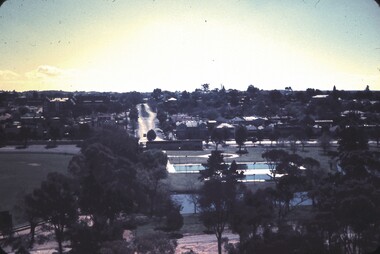
... Bendigo view Rosalind Park Bancroft Street Queen Elizabeth... Inc. History House 11 Mackenzie Street Bendigo goldfields ...View of Bendigo city from lookout tower in Rosalind Park, looking straight up Bancroft Street with Queen Elizabeth Oval (QEO) on Left and Bendigo Aquatic Centre on right..slide, bendigo, bendigo views, bendigo view rosalind park bancroft street queen elizabeth oval bendigo aquatic centre swimming pool -
 St Kilda Historical Society
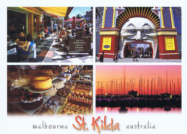
Ephemera - Postcard, Nucolorvue Australian National Souvenir Company 2006, Melbourne St Kilda Australia, 1/1/2006
... Carlisle Street St Kilda melbourne Images of Acland St, Luna Park ...Images of Acland St, Luna Park, Harbour and Cake Shops. Postcard colour Melbourne St Kilda Australia Nucolorvue Australian National Souvenir Company 2006luna park, acland street, st kilda pier -
Clunes Museum
Document - REPORT, WENDY JACOBS, QUEENS PARK CLUNES, JUNE 1994
... BY RICHARD AITKEN 15 FEBRUARY 1990 REPORT QUEENS PARK CAMERON STREET ...CONSERVATION AND ANALYSIS POLICY. ORIGINALLY PREPARED BY RICHARD AITKEN, REVISED AND REPRINTED BY WENDY JACOBS, HERITAGE ADVISER , SHIRE OF TALBOT AND CLUNES. JUNE 1994.REVISED AND REPRINTED FROM THE CONSERVATION ANALYSIS AND CONSERVATION POLICIES ORIGINALLY PREPAREDT BY RICHARD AITKEN 15 FEBRUARY 1990CONSERVATION ANALYSIS AND POLICIES OF QUEEN'S PARK, CLUNES. 54 PAGE, UNBOUND REPORT.- PHOTOCOPIED. REVISED AND REPRINTED BY WENDY JACOBS, HERITAGE ADVISER, SHIRE OF TALBOT AND CLUNES JUNE 1994report, queens park, cameron street