Showing 296 items matching "park west road"
-
 Glenelg Shire Council Cultural Collection
Photograph - Photograph - aerial view of Portland, c. 1974
Port of Portland Authority archives.Front: (no inscriptions) Back: (no inscriptions)port of portland archives, aerial photography, portland harbour -
 Eltham District Historical Society Inc
Negative - Photograph, Tom Prior, Langlands Bridge, Eltham, c.1900
It is noted in the Reynolds Prior collection (Ivy Reynolds) as the first bridge in Eltham however given the current state of knowledge, this is considered unlikely and there is no other supporting source. John Hunter Langlands, owner of the farm known as ‘Ihurst’ on the west side of Diamond Creek to the south of John Wright Murray’s land, died in 1907. In 1909 his land was subdivided into 100 lots to become the ‘Glen Park Estate’. It is possible that the bidge may have crossed the Diamond Creek to Langland's land along the original alignment of Glen Park Road which used to run between present day Progress Road and Coleman Crescent. SEPP Source (c.1970): Mrs. E.R. Reynolds, Thompson Crescent, Research The Reynolds family were early settlers in Research. The Reynolds/ Prior collection of photographs were taken by Tom Prior, the maternal uncle of Ivy Reynolds, around 1900 and the 60 photos in the album give a fine overview of many of the landmarks of Research and Eltham over 100 years ago. lvy lived in the family home for many years at 106 Thompson Cres Research. Ivy's father, Ernst Richard Reynolds and grandfather, Richard Reynolds, lived at the same address. Ivy's father Richard worked for Mr. Trail on his property in Research. Reynolds Road is named after the family. Mr Tom Prior (wife Eva) worked at the Melbourne zoo. He was very innovative and made his own camera, using the black cloth hood to exclude the light. The photographs are a reminder of the rural nature of Research and Eltham and its rich heritage. This photo forms part of a collection of photographs gathered by the Shire of Eltham for their centenary project book,"Pioneers and Painters: 100 years of the Shire of Eltham" by Alan Marshall (1971). The collection of over 500 images is held in partnership between Eltham District Historical Society and Yarra Plenty Regional Library (Eltham Library) and is now formally known as the 'The Shire of Eltham Pioneers Photograph Collection.' It is significant in being the first community sourced collection representing the places and people of the Shire's first one hundred years.Digital image 4 x 5 inch B&W Neg B&W printsepp, shire of eltham pioneers photograph collection, eltham, langlands bridge, reynolds prior collection, bridge, john hunter langlands -
 Eltham District Historical Society Inc
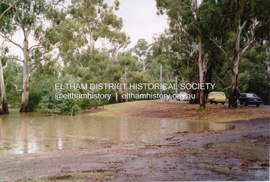
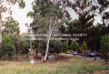
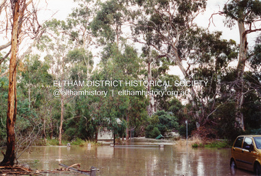
Photograph, Flooding of Diamond Creek at Lower Eltham, Feb 2005, 2005
Three colour photographs of the flooded Diamond Creek showing Main Road floodwater below Dalton Street (Eltham Primary) school, west side of Diamond Creek near flower stall and Wingrove Park, Feb 2005eltham, main road, diamond creek, floods, dalton street, wingrove park -
 Eltham District Historical Society Inc
Photograph, Monash Bridge, Arthurs Creek Road, Hurstbridge, Eltham Heritage Tour, 24 May 1992, 24/05/1992
ELTHAM HERITAGE TOUR The Society excursion on 24th May 1992 was arranged by David Bick, leader of the team carrying out the Shire's heritage study. David selected a number of sites or buildings identified in the study, some of them lesser known components of the Shire's heritage. The tour commenced at the Eltham Shire Office at 10.00 am. Travel was by private car and mini-bus with stops at about twelve locations for commentary by David.It included a short walk in Hurstbridge and lunch at Kinglake. Highlights of the tour included: - 10 am Leave from Shire Offices - 3 Important Trees - A Physical Link to Eltham's First Settlers - Toorak Mansion Gates - A Surviving Farm House - An Intact Circa 1900 Main Street - First Settlers - Gold Miners, and Timber-getters - An Early Hotel - A Pioneering Homestead - Changing Eltham Shire - 20th Century - 4 pm Afternoon Tea and Finish Tour Extract from ELTHAM CULTURAL HERITAGE TOUR (Newsletter No. 85, July 1992, by Bettina Woodburn) "On the Arthurs Creek Road is a bridge designed by Monash, which we admired before walking across the little park with a mud-brick and timber shelter, to the Hurst family graveyard. There are two marked graves, one, Henry who was shot by Burke the bushranger and a cairn has a plaque listing others buried here from 1866 onwards. Burke was captured and tied to the wheel of a dray under the eucalypt near the waterhose/standpipe. Close by the kindergarten, at this place are three trees on the National Trust Register, a Canary Island pine, a Canadian cedar and probably a spruce. Radiata pines and a thick bolled peppercorn surround the little cemetery. Continuing along Main Street we notice elm trees planted as a war memorial, then on the left a 1930 timber house, a 1910 store and residence, resplendent with wrought iron trim, a double fronted Hardware Store and cypresses on the back alignment of a new vacant block. On the right side of the street is a less interesting attempt at an 'in character' shop. Further on are more early homes, one tucked away at the rear with two tall palms by the front steps. Another curiosity is a rounded veranda corner and there are more galvanised iron sheds or garages, before a mud-brick Dentist's Surgery. Beyond the round-a-about is St Peters Church, of mud-brick construction shared by Catholic and Anglican parishioners, overlooking the river flood plain. Leaving Hurstbridge on the Kinglake Road, we ate our picnic lunch beside the communication tower and enjoyed views of Melbourne, Yan Yean Reservoir and the distant Dandenongs beyond the spreading suburbs. Next we drove to the North West boundary of the Shire at Masons Falls Road towards Whittlesea. On the way to the North East Boundary we passed St Peters, a yellow wooden Church with a Tudor Archway; built in the early 1920's in the style of the 1860's. From the Healesville-Kinglake road the rolling hills had European aspects, the hedged fields and chestnut trees. Then it was back down the Hurstbridge Road through 'Aussie' bush of towering gums, with bracken and scrubby understorey, the Kinglake National Park, before more open country with deciduous trees planted in line, and a creek lined with willows."Record of the Society's history and activities and highlighting various aspects of the Heritage Study undertaken by David Bick used to create the future heritage overlay for the Shire of Eltham and later Nillumbik Shire.Roll of 35mm colour negative film, 4 stripsKodak Gold 100 5095shire of eltham historical society, activities, heritage tour, hurstbridge, monash bridge, arthurs creek road -
 Eltham District Historical Society Inc
Photograph, Flooding of Diamond Creek at Lower Eltham, Feb 2005, 2005
Three colour photographs of the flooded Diamond Creek showing Main Road floodwater below Dalton Street (Eltham Primary) school, west side of Diamond Creek near flower stall and Wingrove Park, Feb 2005eltham, main road, diamond creek, floods, dalton street, wingrove park -
 Eltham District Historical Society Inc
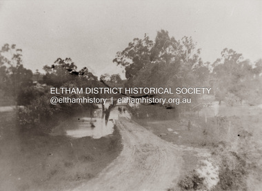
Photograph, Diamond Creek in flood over Glen Park Bridge, Eltham, c. 26 August 1924
Significant flooding of the Diamond Creek occurred in Eltham and Glen Park on Tuesday, August 26, 1924 with several houses swamped and all bridges covered except the Greensborough Road Bridge. [Houses at Eltham Flooded. (1924, August 27). The Argus (Melbourne, Vic. : 1848 - 1957), p. 19. Retrieved from http://nla.gov.au/nla.news-article4156891] The Glen Park Bridge was originally built as a replacement for an older private bridge built by a man named Foley around 1880. In 1911 Heidelberg and Eltham agreed to share the costs to build a new bridge. Construction began in June 1915 and it was officially opened by Cr. Taylor on Cup Day, November 1915. The bridge was destroyed by floodwaters in the afternoon of 20 September 1959 during construction of the new Wattletree Road bridge. The new bridge west embankment joined the existing road at approximately where the bend in the road is situated in the photograph.Colour photograph of originalfloods, eltham, diamond creek (creek), egan's crossing, eltham-diamond creek road, glen park bridge, glen park road -
 Eltham District Historical Society Inc
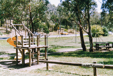
Photograph, Homestead Road, Eltham Lower Park
Eltham Lower Park, looking south west across playground area to Homestead Road, date unknowneltham lower park, parks, reserves, playgrounds, trees, eltham, hohnes hill -
 Warrnambool and District Historical Society Inc.
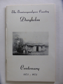
Booklet, The Temiangandeen Country Dergholm, 1973
This booklet gives information on the settlement of Dergholm at the time of the centenary of its founding, 1973. The origin of the name Dergholm is unclear but it may have Irish connections. Europeans came to the area in the 1840s and 50s but it was not until the 1870s that the town was surveyed. Dergholm is in the far west of Victoria 334 kilometres from Melbourne and nearby is Dergholm State Park established in 1982. The booklet was produced for the Centenary Back to Dergholm Committee and the local centenary celebrations. This book is of some interest as it provides information on Dergholm, a settlement in the far west of Western Victoria. This is a soft cover booklet of 52 pages by Alistair Roper. It has a cream-coloured cover with a black and white photograph of early Dergholm on the front cover (Edward Quinn’s house). The booklet has printed material - a President’s Message, an Author’s Note, Acknowledgements, Contents, information on the Dergholm area, including a list of local birds, and References. There are several black and white photographs of the area and its people. The book is stapled. Front Cover: ‘The Temiangandgeen Country, Dergholm Centenary, 1873-1973’dergholm victoria, alistair roper, history of western district of victoria -
 Eltham District Historical Society Inc
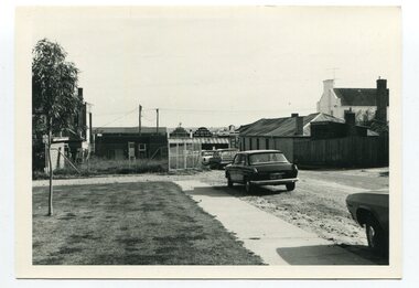
Postcard - Photograph postcard, Boxing Day, Eltham, 26 Dec 1912
Postcard inscribed on reverse "Eltham 26.12.12" In the distance on the hill to the left of centre is the new St Mary's Catholic Church, corner of Main Road and Henry Street, Eltham (blessed 13 October 1912, later destroyed by fire in 1961). Just below the church, Shillinglaw Cottage is visible with two of the Shillinglaw trees partially obscuring the church. Photograph believed to have been taken just west of the present-day Catholic Ladies College carpark in the Inez Avenue Park region with Diamond Street running up hill behind the fence in middle of picture.Digital file only Postcards scanned from the collection of Michael Aitken on loan to EDHS, 13 Feb 2018michael aitken collection, postcards, eltham, picnic, catholic church, exhibition yprl 2019-12, shillinglaw cottage, shillinglaw trees, summer -
 Ringwood and District Historical Society
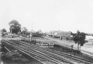
Photograph, Maroondah Highway Central, Ringwood. Main St, looking west showing old railway crossing and station masters home in centre - 1918
Black and white photograph (2 copies)Typed below one copy: "Main St. Looking west showing old railway crossing and station masters home in centre - 1918". Typed below other copy: "Maroondah Highway looking west c1918. Showing old railway level crossing at left. Station masters residence in centre. Shops to right now Eastland car park." -
 Orbost & District Historical Society
black and white photographs, C 1970s
3288.1 has been taken in Lawson Lane, Orbost, looking west from the rear of the Shire Offices. 3288.2 has been taken in Lawson Lane, Orbost, looking east from the rear of the Shire Offices.These photographs are pictorial records of the Orbost township C 1970s.Two black / white photographs showing cars parked on an unsealed road with buildings in the background.lawson-lane-orbost streets-orbost-1970s -
 Eltham District Historical Society Inc
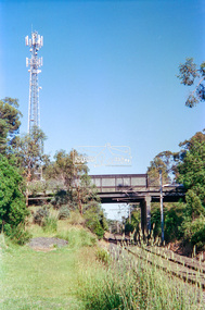
Negative - Photograph, Looking west to Mountainview Road Bridge from Petrie Park, Montmorency, 1998c
Roll of 35mm colour negative film, 8 strips and associated 10 x 15 cm colour printKodak Gold 100-5montmorency, mountainview road bridge, petrie park, railway line -
 Eltham District Historical Society Inc
Photograph, Fred Mitchell, Eltham tip, west of Main Road, Eltham, 1968, 1968
Was reclaimed and developed into part of Eltham Town Park, later Alistair Knox Park.Digital copy of colour photographfred mitchell collection, 1968, main road, alistair knox park, eltham town park, eltham tip -
Federation University Historical Collection
Book, South West Gippsland Tourism Development Strategy, 1989, c1999
Black plastic binding on a report tourism and development strategy report.tourism, tourism strategy, south west gippsland, gippsland, coal creek historical town, wilsons promontory, penguin parade, grand prix, grand ridge road, wonthaggi, phillip island, foster korumburra, inverloch, kilcunda, san remo, bass, bunurong marin park, port franklin, tarwin lower -
Glenelg Shire Council Cultural Collection
Photograph - Photograph - View of Portland Harbour, c. 1974
Port of Portland Authority archives.Front: (no inscriptions) Back: (no inscriptions)port of portland archives, portland harbour -
 Ringwood and District Historical Society
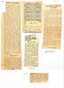
Newspaper, Newspaper articles detailing the acquisition of 40 acres of land for Jubilee Park, formerly known as Sanders Estate, for recreation purposes
Various newspaper articles about detals of the acquisition, by Ringwood Council, of 40 acres of land for Jubilee Park, formerly known as Sanders Estate, for recreation purposes in 1945-1959. The area included named streets - Prussia Road (not West Prussia Road), Duffy Street, Ireland Street, Evens Street and Chapman Street. -
 City of Moorabbin Historical Society (Operating the Box Cottage Museum)
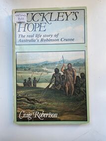
Book, Globe Press Pty. Ltd, Buckley's hope : the story of Australia's wild white man, 1981
A small soft cover book with a blue/green cover,on the front cover is a painting of early Australia with Indigenous Australians hunting with spears alongside them is a European with long unkept hair and a beard dressed in animal skins,on the back cover is text by the author giving a brief outline of the book.buckley, sorrento, robinson crusoe, port phillip, van diemen's land, colonialism, 1840, convicts, indigenous tribes. -
 City of Moorabbin Historical Society (Operating the Box Cottage Museum)
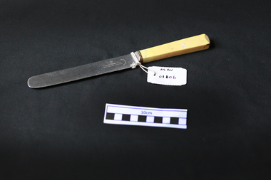
Kitchen Equipment, cutlery, table knife, c1930
Frank Cobb founded his business in West Street , Sheffield in 1903. The firm specialised in plated goods, but also registered marks for silver with Sheffield Assay Office in 1903, 1905 and 1907. The firm grew steadily and aquired Boardman, Glossop & Co in 1923. By 1927 the workforce numbered 250. The manufacture of stainless steel table knives helped the firm expand further in the 1930s, moving to Howard Works in Broad Street in 1933. Records at Sheffield Assay Office indicate that Frank Cobb registered the firm's mark 'FC' on the 15th November 1934. The Frank Cobb Group of companies continued in business well beyond the death of Cobb himself in 1957, eventually being liquidated in 1986. This Stainless steel knife with a bone handle is typical of the cutlery used by early settlers in Moorabbin shire c1930A stainless steel table knife with a bone handle used for the main course of a mealFRANK COBB & C0. / CUTLERS SHEFFIELD / FIRTH'S STAINLESScutlery, stainless steel, frank cobb & co sheffield, england, early settlers, market gardeners, moorabbin, cheltenham, bentleigh, -
 City of Moorabbin Historical Society (Operating the Box Cottage Museum)
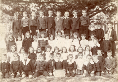
Photograph, 2 x Black & White Beaumaris State School , Miss Reynolds 1906, 07, 1906, 1907
Teacher Miss Reynolds is shown with her 'Upper Class' in 1906 and '2nd Class' in 1907. West Beaumaris School No 84 in Charman Road Stephen Charman, 1821-1906 a market gardener, donated land for the first Methodist Chapel, Cemetery and School in Charman Rd Cheltenham 1855. The enrolment was 36 pupils with Mr Frederick Meeres as Teacher. 1863 the school is called Beaumaris Common School No 84 with 70 pupils and Walter Meeres as Teacher. 1869 another 2 acres in Charman Road were granted by the Education Board and brick building built . 1872 State School 84 Beaumaris was increasing enrollments and 1878 a new brick school was built to accommodate 174 pupils and the name changed to Cheltenham State School No.84 1894 Mentone State School No.2950 amalgamated with Cheltenham SS No.84. 1910 the buildings were in disrepair, overcrowding was increasing and renovations were made 1912 with further additions in 1925 and 1937. Post WW11 extra prefabricated Classrooms were added as enrollment increased to 1038 in 1955.. Cheltenham East State School 4754 was opened as housing development spread over the City of Moorabbin . ( J Larson Sandringham HS)1855 Stephen Charman donated land to the Methodist Church so that a School could be established to educate the children of the early settler market gardeners and farmers in the Cheltenham area . Education was valued by the general community and as well as schools they established mechanics Institutes and Libraries in Moorabbin Shire. Cheltenham State School No. 84 was among the first schools in Melbourne.2 x Black & White Photographs of Beaumaris State School pupils with Miss Reynolds in 1906 and 1907Hand written ; Warburton, B. Wooff, R. Whelan, Miss Reynoldscity of moorabbin, county of bourke, moorabbin roads board, parish of moorabbin, shire of moorabbin, henry dendy's special survey 1841, were j.b.; bent thomas, o'shannassy john, king richard, charman stephen, highett william, ormond francis, maynard dennis, cheltenham state school no.84, methodist chapel cheltenham, methodist school cheltenham, beaumaris west state school, meeres frederick, meeres walter, education, early settlers, -
 City of Moorabbin Historical Society (Operating the Box Cottage Museum)
Domestic object - Ornaments, Fenton's Blue vase, Circa 1906 to 1940s
The Fenton Art Glass Company was founded in 1905 by brothers Frank L. Fenton and John W. Fenton in an old glass factory in Martins Ferry, Ohio. Originally, they painted glass blanks from other glass makers, but started making their own glass when they became able to buy the materials they needed. They moved across the Ohio river to Williamstown, West Virginia, and built a factory in 1906. The first year for glass production was 1907. Frank Fenton was the designer and decorator. Jacob Rosenthal, a famous glass chemist is known for developing chocolate and golden agate glass. Perfume bottles for the Wrisley Company in 1938 were made in French opalescent glass with the hobnail pattern In 1939, Fenton started selling Hobnail items in milk glass. During the Great Depression and World War II, Fenton produced practical items such as mixing bowls and tableware. Fenton ceased "traditional" glassmaking at the Williamstown, West Virginia factory in July of 2011. However, the factory remains open as a jewellery making operation, producing handcrafted glass beads and Teardrop earrings.Late early to mid 20th century Jack-in the- Pulpet style Fenton vase. Hand-blown outer aqua blue glass over base of white milk glass. Heavily ruffled and crimped rim, with clear glass edging. The narrow neck joins to larger circular base. The body of the vase is also decorated with swirling ridges. Clear glass handle. Pont mark on base, but no Makers Mark. Fenton's glassware bore no Makers Mark until the 1950s.glassware, lights, fenton art glass company, ohio, west virginia, usa, fenton frank l., fenton john w., rosenthal jacob, early settlers, pioneers, market gardeners, moorabbin, bentleigh, ormond, cheltenham -
 City of Moorabbin Historical Society (Operating the Box Cottage Museum)
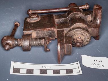
Tools, steel vice, c1900
Perak or State of Perak one of the 13 states of Malaysia, is the second largest state in Peninsular Malaysia. It borders Kedah and the Thai Yala Province to the north; Penang to the northwest; Kelantan and Pahang to the east; Selangor to the south, and the Straits of Malacca to the west. The state's administrative capital of Ipoh was known historically for tin-mining activities until the price of the metal dropped, severely affecting the state's economy. A vice is a tool with 2 jaws between which an object is gripped, usually by tightening a screw, so as to leave the hands free for working upon it. The vice is usually firmly attached to a bench . A steel vice THE PERAK TIN MINING COMPANYtools, vice, steel , clamps, metalwork, woodwork, carpentry, early settlers, pioneers, market gardeners, moorabbin, bentleigh, cheltenham, blacksmiths, perak tin mining co. -
 City of Moorabbin Historical Society (Operating the Box Cottage Museum)
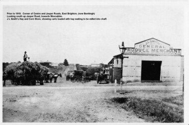
Photograph - Photograph Hay & Corn Store, Before 1910, Smith's Hay & Corn Store, Cnr. Centre and Jasper Roads, Bentleigh, Late 19th to early 20th Century
The first photograph was taken prior to 1910. The location is at the corner of Centre and Jasper Roads, East Brighton, (now known as Bentleigh). It is an early view of John L. and "Minnie" Smith's Hay and Corn Store, situated on the South West corner of those two roads. The first photo was taken prior to the introduction of electricity in the area. A gas lamp and horse "hitching post" can be seen "in shot". There are several loaded wagons waiting in line to have their hay milled to chaff. Farmers came from places as distant as Carrum to have their loads of hay milled into chaff. John Smith was born in 1860 in Point Nepean Road, Brighton, and Minnie was born in Patterson Road, Moorabbin, in a wattle and daub cottage with earthen floor and butter muslin over the windows. The couple married in 1884, Minnie was a devout Methodist and the family became very involved in the development of the local Methodist church. The couple had four children and during the 1890s Depression their first child died, they lost all their possessions, and John's family struggled to survive. Finally in the late 1890s JL Smith was able to rent a shed from Mr Henry Box on the corner of Centre and Jasper Roads, and he later purchased that property. With the gradual improvement in the economy, and the development of the successful market gardening industry in the Shire of Moorabbin, JL Smith's produce store became quite prosperous. Over some years the little "shed" developed into a thriving Hay and Corn Store. JL Smith went on to become Moorabbin Shire President in 1914. He and his wife were active in assisting soldiers returning injured from the 1st WW, in the local Methodist Church and other early community projects. Smith was a typical example of the majority of the early settlers in the Shire of Moorabbin, being god-fearing and devoted to the idea of service to the community. The photographs demonstrate the primitive conditions and early development of what is now a bustling and well-recognised area of Bentleigh, (known as east Brighton before 1907). The photo shows a gas lamp in use before the introduction of electricity in 1916. The Smith's story is representative of the many early pioneering traders, who elected to "set up shop", who suffered the adversity of the 1890s depression, but who survived and made their living in the largely undeveloped area of East Brighton ( now Bentleigh) district. Two black and white early photographs both of the same location. The photos are of the corner of Centre and Jasper Roads, Bentleigh. (Prior to 1907 this area was known as East Brighton.) Both photos show J.L Smith's General Merchant Produce store. "Steam Chaff Cutting and Corn Crushing Mills" and the surrounding area at differing stages. In the first photo taken prior to 1910, we can see there are several horse-drawn carts loaded with hay waiting to be milled, a gas lamp and a horse "hitching post". The store is just a single unadorned, shed. The later, second photo of the same area, shows improvements and the further development of that site. On the back of the photo "Hay and Corn Store -/ not later than 1910."/"Photographer /Victor C Smith,/ Phone Number XL1472"/hitching post, methodist church, smith minnie, moorabbin shire president, gas lamp, east brighton district, 1890s depression, wattle and daub cottage, centre road, jasper road, box henry, smith john l -
 City of Moorabbin Historical Society (Operating the Box Cottage Museum)
Photograph - Map of Dendy's Special Survey, 1852 Map of Henry Dendy's Special Survey of 1841, 19th Century
A Map drawn in 1852 that shows the 5,120 acres that formed Dendy's Special Survey of 1841. In 1840 Henry Dendy, a farmer in Surrey, England acquired a "Special Survey" from the Commissioners for Land and Emigration which gave Dendy the right to choose land in Port Phillip for the "bargain basement" price of only £1 per acre for 5120 acres, (an area of 8 square miles). The Special Survey also included the right to "the shipment of a worker for every £20 spent on land, whose free passage was paid by the Crown, equalling a total of 100 workers ". Accordingly Dendy sold his English holdings and paid the required £5120 and arrived in Melbourne in February 1841. However by this time land in the new colony was selling for £5 - £40 per acre. Because Henry Dendy possessed the order from the Colonial Office in London he was able to successfully oppose Governor LaTrobe's attempts to alter the price of the land. Dendy appointed Jonathan Were, (an entrepreneur, who had arrived in 1839), as his Manager and who later became a partner. Together, Dendy and Were decided on an area 5 miles south from Melbourne, bounded by North Road, East Boundary Road, South Road and to the west by Port Phillip Bay. Were and Dendy pitched their tents in the area now known as ' Park St, Brighton' and sank a well near the corner of 'St Andrew's St and Wells St'. By 1845 J.B Were and Company had bought almost half of Dendy's land and Were built himself "Moorabbin House" in Were St Brighton made from stone, quarried from local cliffs. It was still standing in 1924. Legend records Moorabbin is named after the Aboriginal word for ' Mother's Milk ' The soil is very fertile and well supplied with water especially in the area called 'East Brighton' - now known as Bentleigh and East Bentleigh - By 1850 the area had developed with numerous market gardens, dairy farms, fruit gardens and vineyards supplying food for the growing population of Melbourne.This Map shows the birth of the Brighton and Moorabbin area. On 18th January1859 Brighton was proclaimed a Municipality and a Borough by October 1863. Meanwhile, following a Petition, the area of East and South Brighton, incorporating Mordialloc, Cheltenham, Mentone, Sandringham and Oakleigh separated from Brighton to form the Moorabbin District Roads Board becoming the first Local Government Authority. Col. William Mair was elected as the first Chairman of the Moorabbin Roads Board. Moorabbin Shire 1871 developed further and was declared a City in1934. The City of Moorabbin was the largest Municipality in Melbourne before the Amalgamation of Councils in 1994 when it was divided in the south to City of Kingston and in the north to City of Glen Eira A Photo-lithographed 1852 Map showing the 5,120 acres that formed Dendy's Special Survey of 1841. Henry Dendy & Jonathan Were chose an area 5 miles south from Melbourne, bounded by North Road, East Boundary Road, South Road and to the west by Port Phillip Bay. Moorabbin County of Bourke / Photo-Lithographed at the department of Lands and Survey. /Melbourne. / Price 1/- brighton, moorabbin, bentleigh, cheltenham, dendy henry, bent thomas, were jonathan, special survey -
 City of Moorabbin Historical Society (Operating the Box Cottage Museum)
Functional object - Kitchen Equipment, Coolgardie Safe, c1900
The invention of the Coolgardie Safe is credited to Arthur Patrick McCormick, a contractor in Coolgardie, and later the Mayor of Narrogin. Coolgardie is in the Eastern Goldfields region of Western Australia. Gold was first discovered there in 1892; the townsite became a municipality in 1894, and by 1898 its population of 15,000 made it the third largest town in Western Australia after Perth and Fremantle. In the last decade of the 19th century, Coolgardie was the capital of the West Australian goldfields. Being 180 kilometres from the nearest civilisation, food supplies were initially scarce and expensive. As fresh food was a valuable commodity there was incentive to preserve it, and keep it out of reach of scavengers such as birds, dingos, dogs, ants, and flies. It was in an effort to do this, in the extreme heat of the Australian Interior, that McCormick came up with his design for the Coolgardie Safe. McCormick noticed that a wet bag placed over a bottle cooled its contents. He further noted that if this bottle was placed in a breeze, the bag would dry out more quickly, but the bottle would get colder. What McCormick had discovered was the principle of evaporation: ‘to change any liquid into a gaseous state requires energy. This energy is taken in the form of heat from its surroundings.’ Employing this principle, McCormick made a box for his provisions which he covered with a wet hessian bag. He then placed a tray on top, into which he poured water twice daily. He hung strips of flannel from the tray so that water would drip down onto the hessian bag, keeping it damp. As the water evaporated, the heat dissipated, keeping the food stored inside cool and fresh. The success of McCormick’s invention would not have worked without a steady supply of water. Fresh water was scarce in the eastern goldfields at this time but the demand for water from a steadily growing population encouraged innovation. The solution was to condense salt water. Heating salt water in tanks produced steam that was condensed in tall cylinders, cooled and then collected in catchment trays. By 1898 there were six companies supplying condensed water to the goldfields, the largest company producing 100,000 gallons of water a day. In the early 20th century, Coolgardie Safes were also manufactured commercially. These safes incorporated shelving and a door, had metal or wooden frames and hessian bodies. The feet of the safe were usually placed in a tray of water to keep ants away. (MAV website) The early settlers of Moorabbin Shire depended on this type of Food Safe to protect their food from flies and vermin as they established market gardens in the fertile area around the notorious Elster Creek A metal framed, 4 sided structure standing on 4 legs with 2 hinged doors on one side, a metal tray at base of food safe and a metal cover over top. Ridges on which to rest trays carrying food are inside safe. The Safe is enclosed by fly-wire mesh.'...IN.....GEELONG' A manufacturer's oval metal plate is embossed on one side of Safe but it is illegible.elster creek, moorabbin, brighton, dendy's special survey 1841, market gardens, infant mortality, disease, cemeteries, fruit, vegetables, pioneers, coolgardie safe, mccormick arthur patrick, dendy henry, vaccination, jones martha, jones ethel may -
 City of Moorabbin Historical Society (Operating the Box Cottage Museum)
Document - Document , photocopy of Steerage Passenger Ticket 1912, 1912
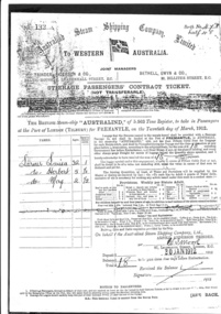
'Australind' steam ship built 1904 by C. Connell & Co. Ltd., Glasgow .1928 sold to France renamed Colbert, 1933 sold renamed Scandinavia, 1934 scrapped at Savona.In the 1880s Trinder, Anderson & Co. joined Charles Bethell and started operating a twice monthly service from Great Britain to Fremantle and Albany. In 1886 Trinder, Anderson & Bethell started a steamer service called the West Australian Steam Navigation Co. at London. Their first steamer was given the name AUSTRALIND. In 1904 Bethell, Gwyn & Trinder, Anderson formed the Australind Steam Shipping Co.The new company was involved in the transport of emigrants. In 1912 the company owned five ships. During World War I the company lost four of its six ships. In World War II the company lost two ships. In the 1970s the company withdrew from the liner services and started hiring ships to other companies. The last cargo ship was disposed off in 1981 / 1982.The ‘Australind’ steam ship brought migrants from England to Australia 1904 - 1926 A photocopy of a Steerage Passenger’s Contract Ticket for Louisa Larner and her children Herbert aged 5 and May aged 2 aboard the British Steam-ship ‘Australind ‘ departing Tilbury England March 20th for Fremantle, Australia. a) front of ticket b) enlargement of a section of the ticket a) No 132 Berth No, 47 & half 48 / Australind Steam Shipping Company Limited / TO WESTERN AUSTRALIA / central flying flag with a black swan on a white cross -/ JOINT MANAGERS/ TRINDER ANDERSON & CO., l BETHELL, GWWYN & CO., BALTIC HOUSE LEADENHALL STREET EC. 22 BILLITER STREET, EC. STEERAGE PASSENGER’S CONTRACT TICKET / ( NOT TRANSFERRABLE ) / The British Steam-ship “Australind” of 5,563 Tons Register, to take in Passengers / at the Port of London ( TILBURY) for FREMANTLE, on the twentieth day of March 1912 Signed W I Moore dated 30Jan1912 paid £18 Larner Louisa age 32 adult1 / do Herbert age 5 adult ½ / do May age 2 adult ½ written on ticket b) photocopy enlargement of a section of the ticket showing names and signatures london, tilbury, fremantle, steamship, ss australind, steerage, passengers, immigration, provisions, rations, trinder anderson company, larner louisa, larner herbert, larner may, bethel gwyn company -
 City of Moorabbin Historical Society (Operating the Box Cottage Museum)
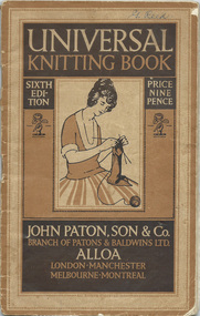
Booklet - 'Universal Knitting Book' Paton, John Paton, Son & Co. 6th Edition 1923, c1923
Gladys Reed was a member of the Ormond Choral Society c 1950. who performed plays and musicals the City of Moorabbin and she was skilled in hand knitting, crochet and dressmaking. Her garments were used by her family and the Ormond Choral Society . Patons' & Baldwin Ltd began as two separate companies: J & J Baldwin and Partners, founded in the late 1770s by James Baldwin of Halifax, West Yorkshire, England, and John Paton Son & Co., founded in 1814 by John Paton of Alloa, Scotland. Both men had formed their businesses using the spinning mule developed by Samuel Crompton. They mainly produced yarns for commercial knitting machines. The two companies merged in 1920 and diversified into producing wool for home knitters, as well as publishing knitting patterns under the "Patons Rose" and "Baldwins Beehive" trademark. By the mid-1930s, the company had establishments across Scotland and Northern England, Canada, New Zealand, Launceston, Tasmania, Australia. The company branched out into various related lines of business, and the development of new products such as nylon and Terylene. In 1961, the company was merged with J & P Coats Ltd. The Patons trademark is still in use today.The yarn production facility at Alloa was closed in 1999 and the large factory in Launceston, Tasmania, Australia,closed in 1997. In 1952 J. & P. Coats and the Clark Thread Co. merged.and in 1961 a merger with Patons and Baldwins created Coats Patons. In 2015 the business returned to the market as "Coats Group".Patons' knitting books have been used by hand knitters in many countries since they were published early in 20thC Gladys Reed and other residents of the City of Moorabbin used these pattern guides to make clothing for their families and community c1950A printed paper booklet with 64 pages of knitting and crochet patterns, instructions, photographs bound by 2 metal staplesFront Cover ; UNIVERSAL/ KNITTING BOOK / SIXTH / ED / ITION / PRICE / NINE / PENCE / Photo of lady knitting / Trade Mark / JOHN PATON, SON & CO. / BRANCH OF PATONS & BALDWINS LTD. / ALLOA / LONDON, MANCHESTER / MELBOURNE / MONTREAL Written top right ; G Reed Back Cover ; Trade Mark / Registered / THIS TRADE MARK / IS YOUR GUARANTEE / WHEN BUYING / PATONS' ALLOA / KNITTING WOOLS knitting, crochet, craftwork, john paton son & co., baldwin j &j ltd, aloa scotland, launceston tasmania, melbourne, knitting mills, knitting books, coates j&p ltd, early settlers, moorabbin shire, mechanics institute cheltenham, ormond choral society, postworld war 11 settlers, housing estates moorabbin 1950, bentleigh, ormond, moorabbin, cheltenham, drama societies, musical society cheltenham, clark judy, reed gladys, reed george -
 City of Moorabbin Historical Society (Operating the Box Cottage Museum)
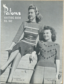
Booklet - Patons Knitting Book No.182, Patons & Baldwins Ltd, c1950
Gladys Reed was a member of the Ormond Choral Society c 1950. who performed plays and musicals the City of Moorabbin and she was skilled in hand knitting, crochet and dressmaking. Her garments were used by her family and the Ormond Choral Society . Patons' & Baldwin Ltd began as two separate companies: J & J Baldwin and Partners, founded in the late 1770s by James Baldwin of Halifax, West Yorkshire, England, and John Paton Son & Co., founded in 1814 by John Paton of Alloa, Scotland. The two companies merged in 1920 and diversified into producing wool for home knitters, as well as publishing knitting patterns under the "Patons Rose" and "Baldwins Beehive" trademark. By the mid-1930s, the company had establishments across Scotland and Northern England, Canada, New Zealand, Launceston, Tasmania, Australia.Patons' knitting books have been used by hand knitters in many countries since they were published early in 20thC Gladys Reed and other residents of the City of Moorabbin used these pattern guides to make clothing for their families and community c1940A printed black and white booklet with 31 pages of knitting instructions and photographs c 1940Front Cover ; Patons / Knitting Book / No. 182 / 'Rhumba' See page 14 'Swing" See page 15 / 6d ( decimal = 5cents) Back Cover ; Patons / No. 182 / Knitting Book / 'Fandango ' /See page 17 / 'Tarantella' /See page 18knitting, crochet, craftwork, john paton son & co., baldwin j &j ltd, aloa scotland, launceston tasmania, melbourne, knitting mills, knitting books, coates j&p ltd, early settlers, moorabbin shire, mechanics institute cheltenham, ormond choral society, postworld war 11 settlers, housing estates moorabbin 1950, bentleigh, ormond, moorabbin, cheltenham, drama societies, musical society cheltenham, clark judy, reed gladys, reed george -
 City of Moorabbin Historical Society (Operating the Box Cottage Museum)
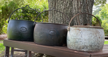
Functional object - Set of three Cast Iron Cooking Pot, A Kenrick & Sons - West Bromwich
The cooking pots were used by Pioneer's of the City of Moorabbin.Black cast iron cooking boiler pots with lidsA. Kenrick & Sons/9 Galls / West Bromwichcooking, moorabbin, pioneers, cast iron pots