Showing 245 items
matching pathways
-
 Lakes Entrance Historical Society
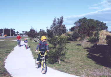
Photograph - Cycle pathway between Bullock Island and North Arm Bridge, L E Tidy Town Committee, Lakes Entrance Victoria, 1994 c
Colour photograph of three cyclists on shared pedestrian and cycle pathway between Bullock Island Road and North Arm Bridge Lakes Entrance Victoria transport, recreation, roads and streets -
 Bendigo Historical Society Inc.
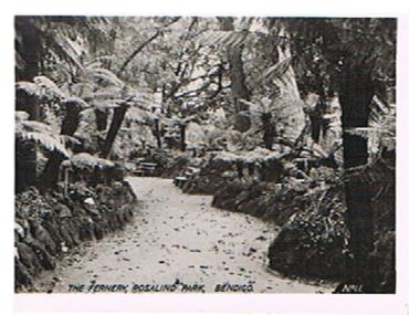
Photograph - FERNERY, ROSALIND PARK, BENDIGO
Photograph, black and white. Image shows the Fernery, Rosalind Park. Tree ferns, rock bordered pathway. On bottom : The Fernery, Rosalind Park, Bendigo, No. 11'cottage, miners -
 Ballarat Heritage Services
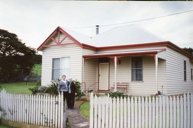
Photograph - Photograph - Colour, 'Hillside', 41 McCartney Lane, Crossley
Weatherboard house at Crossley, Victoria. The house used to be the home of Patrick and Mary Carroll, and their family. Sisters Rosemary Carrill (left) and Kathleen Carroll stand on the pathway.crossley, hillside, mccartney lane -
 Sunbury Family History and Heritage Society Inc.
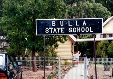
Photograph, Bulla Primary School, Early 1990s
The Bulla Primary School was a semi-rural school in the Bulla township which was established in 1872. It was one of the first government schools to open in the district and continued to function for the following 124 years until December 1996 when the State Government closed the school. After that date, Bulla children were bused to schools in either Sunbury or Greenvale. The school property is now privately owned.Along with Bulla Primary School there were a number of Victorian Government schools closed down and sold to private enterprise in the 1990s.A coloured photograph of the school notice board erected at the main gate of the school. Two of the buildings are partially visible in the background. Four girls are standing on the main pathway.bulla primary school -
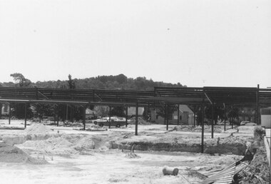 Ringwood and District Historical Society
Photograph, New Ringwood Market under construction 18/1/1983
Written on back of photograph, "E653, N20A. 18/1/83. Loughnan's Hill through frame of market. Telecom buildings pathway extreme right." -
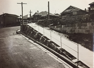 Kew Historical Society Inc
Photograph, City of Kew, Public Works, Road Making, c.1920s
An original photograph donated to the Kew Historical Society by the City's Engineering Department before the amalgamation of Kew into the City of Boroondara in 1994. While not all of the photographs are of Studley Park, Kew or East Kew, each photo provides a fine snapshot of the work of local government engineering departments of the period. They reveal they types of labour conducted, the techniques used and the equipment and machinery in the possession of the local government authority.Public works. A high retaining wall holds back an embankment on a steep slope around which a road turns. It is believed that the photograph dates from the 1920s. Inscription on reverse: "A difficult corner designed to obviate the use of steps. / Pedestrians using the road in front of the dwellings step off the pathway at the telegraph pole".city of kew (engineering department), engineering, road construction building -
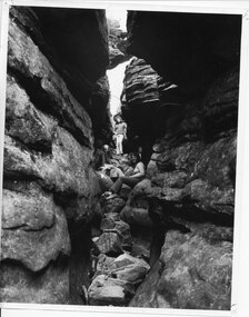 Halls Gap & Grampians Historical Society
Photograph - B/W
the three women appear to be in 'Silent Street', part of the Wonderland Range on the pathway to The Pinnacle lookout.3 young women sitting and standing amongst 2 rock cliffs with tumbled rocks that appear to form steps. a railing can be seen behind standing girl. Clothing is suggestive of the 1970s period.scenery, wonderland range -
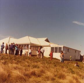 Phillip Island and District Historical Society Inc.
Photographs, John Cook, 1978-79
Photographs a part of the John Cook album.Three photographs of The Nobbies Kiosk. 81-93 & 93a. View from the car park with many visitors 81-93b. View taken from the pathway to The Nobbiesthe nobbies kiosk, the nobbies phillip island, tourists, john cook -
 Phillip Island and District Historical Society Inc.
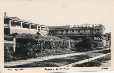
Photograph - Post Card, Unknown
Donated by Jean BainBlack & White Postcard of Bayview Guest House with "Bayview" written on roof and "Bayview Guest House" sign at front entrance. Hedged fence and street pathway in front.Photo Shop Series Bayview Guest House Cowes.bayview guest house, guesthouses cowes phillip island, phillip island, jean bain -
 Bendigo Historical Society Inc.
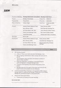
Document - CITY OF GREATER BENDIGO PRESENTATION
Bendigo Stake holder Consultauion - Bendigo Creek Sewer. February 4 2005. City of Gretaer Bendigo. Includes photographs of intended pathway through the Bendigo Creek. -
 Lakes Entrance Historical Society
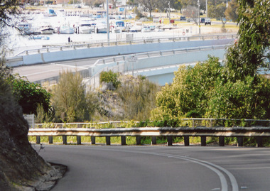
Photograph - North Arm Bridge, 2008
Date made September 2008Colour photograph showing the new North Arm bridge opened 2000, taken from pathway besides Princes Highway at west end of Lakes Entrance, Victoria.bridges, waterways, roads and streets -
 NMIT (Northern Melbourne Institute of TAFE)
Booklet and Brochures - Tourism Courses NMIT 2002-2005, 2005
This booklet outlines courses and career pathways associated with various courses within the NMIT Tourism Department.Booklet of 24 pages of text, colour illustrations and flow charts for 2005; Brochures for 2002 and 2003.tourism, tourism industry, events management, courses, nmit, -
 Lakes Entrance Historical Society
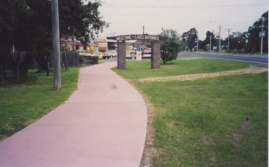
Photograph - Eastern entrance to Lakes Entrance, Lakes Entrance Tidy Town Committee, 1990
Colour photograph showing Eastern entrance to town Princes Highway on right of image pathway to left of Welcome to Lakes Entrance sign holding metal sign indicating local services Lakes Entrance Victoria. Also two other colour photographs taken at Eastern entrance to Lakes Entrance from pathway beside St. Brendans looking towards Eastern Beah Road Tidy Town signs in foreground topography, signage, tidy town -
 Bendigo Historical Society Inc.
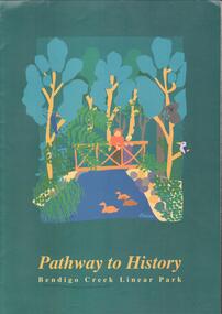
Document - PATHWAY TO HISTORY - BENDIGO CREEK LINEAR PARK
Coloured brochure. Drawing of a man and child standing on a bridge over a creek, bush aroud with several native animals and birds. Pathway to history, Bendigo creek linear park.bendigo, parks and gardens, bendigo creek linear park -
 Bendigo Historical Society Inc.
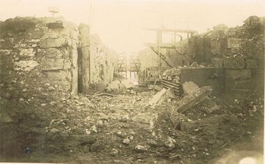
Postcard - ACC LOCK COLLECTION: SEPIA PHOTO OF RUINED BUILDINGS, POSTCARD, CARTE POSTALE, 1914-1918
Postcard, WW1, Sepia photo of some ruined buildings either side of a pathway. Wooden gate in background. Location not known. G47 written in pencil on the back and stamped B148postcard, postcard, ww1, france, ruins -
 Sunbury Family History and Heritage Society Inc.
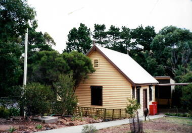
Photograph, Bulla Primary School, c1993
The weatherboard building was one of three erected in the former Bulla Primary School grounds. The original school building was constructed from bluestone as was the case with many other buildings in the district. A non-digital coloured photograph of a cream weatherboard building with brown trims. There are tall conifers and gum trees trees in the background and a concrete pathway leading to the building's front door.bulla primary school, school buildings -
 Sunbury Family History and Heritage Society Inc.
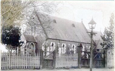
Photograph, St. Mary's Anglican Church, Pre1910
This is an early photograph of St. Mary's Anglican Church in Sunbury. On 13th October 1863, the Government granted one acre of land on the corner of Stawell and O'Shanassy Streets for the building of a church. he first service was held on 24th November 1867. After that date subsequent additions were made. The gas lamp outside the church indicates that the photograph was taken before electric power was installed in Sunbury. St. Mary's Anglican Church is one of the earliest places of worship to be built in Sunbury.A non-digital sepia post card photograph of a small bluestone church with a slate roof with a wooden picket fence and two gates across the front. A gas lamp is on the pathway. Peter Collett's signature is on the back as well as a sticker with number 7 written on itst. mary's church of england., o'shanassy street, stawell street -
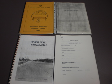 Wangaratta High School
WHS Student Pathway Reports, 1772-1885
Four booklets containing analyses of ex-student post-secondary education pathways. 1972: WHICH WAY WANGARATTA. A white bound booklet with a large black and white image of a Wangaratta street on the cover, analysing the pathways of students who graduated in 1972. 1983: WHERE HAVE ALL OUR STUDENTS GONE. A yellow bound transition education research project booklet with a WHS logo and a large double headed arrow and question mark symbol on the cover, analysing the pathways of students who graduated in 1983. 1987: WHY DO YOUNG PEOPLE LEAVE THE WANGARATTA REGION: A grey stapled booklet containing a WHS student survey report on the reasons young people leave the Wangaratta region after their secondary schooling 1994: CLASS OF 94. WHERE DID THEY GO: A white stapled booklet containing an analysis of WHS students graduating in 1994 and their post-secondary education pathways -
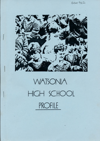 Greensborough Historical Society
Booklet, Watsonia High School Profile, 1986_
An introduction to Year 7 includes Year 7 curriculum, pathways into subsequent years and an outline of school rules and services.A snapshot of the Year 7 curriculum and school rules at Watsonia High School in 19866 typed pages, blue cover with black and white image. -
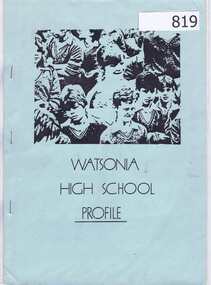 Greensborough Historical Society
Booklet, Watsonia High School Profile, 1986_
An introduction to Year 7 includes Year 7 curriculum, pathways into subsequent years and an outline of school rules and services.A snapshot of the Year 7 curriculum and school rules at Watsonia High School in 19866 typed pages, blue cover with black and white image.watsonia high school, curriculum -
 Bendigo Historical Society Inc.
Photograph - BOTANICAL GARDENS
sepia photograph on cream board. Driveway/pathway, gravelled, eucalypt and conifer trees, uncut grass, wire fence middle distance. Pathway curving to left from front of photo. Written in blue pen on rear of photo : Botanical Gardens or early path in Fortuna. English trees planted, e.g. cypress. Holdsworth Road, adj. White Hills Cemetery Reserve. Crowned road grade. Heavy intermediate fence posts.unknownplace, land, botanical gardens, fortuna ? -
 Lakes Entrance Historical Society
Photograph, Fish, Marie, 1990c
Colour photograph of the kiosk on the sand hummocks. It shows a corner of the kiosk, the rustic garden, picnic tables and seats. Pathway to footbridge and glimpse of Cunninghame Arm in distance. Lakes Entrance Victoriarestaurant, recreation, room display -
 Sunbury Family History and Heritage Society Inc.
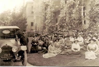
Photograph, c1914 - 1918
The image was taken of Women's Auxiliary group gathered on the lawns of Rupertswood Mansion some time between 1914 and 1918. The women's group organised various events to aid the war effort and were often invited to the mansion.During war time many community groups were formed to raise funds which supported the war effort in a variety of ways.A non-digital copy of an old sepia photograph of a group of women sitting on the lawn outside a large mansion. An early car is parked on the pathway to the left of the image and the driver is standing next to it.women's auxiliary, rupertswood mansion, world war 1 -
 Vision Australia
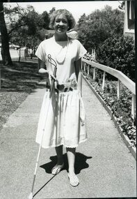
Photograph - Image, Patricia Hodges, 1989
RBS client, Patricia Hodges, uses a white cane to walk up the pathway to the front doors of RBS Enfield office.1 B/W photograph of woman using white cane as she walks up path at EnfieldPatricia Hodges, 22 years, (visually impaired) Royal Blind Society 1989royal blind society of nsw, white cane day, orientation and mobility, patricia hodges -
 University of Melbourne, Burnley Campus Archives
Photograph - Black and white print, 1/3, 1942
The Long border" towards the centre of the grounds where was located the Principal's Residence. Existing lily ponds at right of pathway." THK"Looking along the "Long border" towards the centre of the grounds where was located the Principal's Residence. March/April 1942.long border, principal's residence, lily ponds, e. m. gibson collection -
University of Melbourne, Burnley Campus Archives
Photograph - Black and white print, 1/4, 1942
The Long border" towards the centre of the grounds where was located the Principal's Residence. Existing lily ponds at right of pathway." THK"Entrance to Horticultural Gardens. March/April 1942.horticultural garden, rockery, e. m. gibson collection -
 Stawell Historical Society Inc
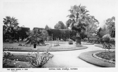
Photograph, Rose Series, Central Park Gardens, c 1910 - 1920
Central Park Gardens Rose Series Postcards P1664. Shows Several Palm trees circular gardens and pathways. c1910-1920.Postcard of The Rose Series P. 1644 Central Park, Stawell. Also included are two enlarged copies of the post card. Post card shows hedge of cypress in the background and various sized Palm trees in round garden beds in the foreground. c1910 - 1920With best wishes for the New year from Bob & Mary written on the back of the post card. Issued by The Rose Stereographs Armadale Victoriastawell, tourism -
Port Melbourne Historical & Preservation Society
Book, Phil Rickard, Light Railways; Australia's Magazine of Industrial and Narrow Guage Railways, 2019
June 2019 issue of Light Railways; Australia's Magazine of Industrial and Narrow Guage Railways. Article - Pathways around Melbourne page 2, page 8 containing details of Port Melbourne.Number 267 ISSN 07278101 June 2019. $7.95 recommended retail price onlytransport - railways, history, industrial and narrow guage railways -
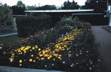 Bendigo Historical Society Inc.
Slide - BENDIGO VIEWS, Mar 1971
Slide. Bendigo Views. A flower bed with marigolds, roses and another red flower along the left edge. There is a pathway along the right edge of the bed. Behind the flower bed are shrubs and a shed.slide, bendigo, bendigo views, bendigo views -
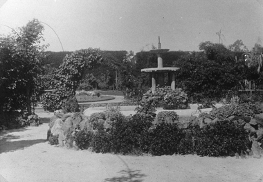 Stawell Historical Society Inc
Photograph, Central Park Gardens, c1910
Photograph of Central Park Gardens showing rockery and fountain at center. c1910 Records state the copy was made from original loaned by Barry Griffin.Enlarged Black & White photo of Central Park Gardens showing water fountain surrounded by pathways, lawns and gardens. Duplicate photo also in Griffin Album on page 25, measurements given.stawell