Showing 171 items matching "phillip island map"
-
 National Vietnam Veterans Museum (NVVM)
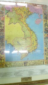
Map - Map, Vietnam
Colour map of vietnam and neighbouring countries with a decorative border of cultural aspects in a gilt framedonated by the Pham Family to National Vietnam Veterans Museum 9.03.2007map, vietnam -
 National Vietnam Veterans Museum (NVVM)
Memorabilia, Memorabilia of Raylene (Sykes) Nagy
Contains 7 letters and a map that were sent to her during the Vietnam War by Donald George Woo.vietnam war, 1961 - 1975 -- veterans -- australia, 3rd cavalry regiment -
National Vietnam Veterans Museum (NVVM)
Memorabilia, Memorabilia of Neil Ernest Swainston
Contains photocopies of his Army documents & 6 microfiche of contour maps (?)vietnam war, 1961-1975 - personal narratives - australian -
National Vietnam Veterans Museum (NVVM)
Memorabilia, Memorabilia of James Archbold
Contains a letter to his father from the AMF re James's recruitment training; a photocopy of the National Service Termination Act; a copy of a cartoon titled, Lend me your body for 730 days, a copy of H.M.A.S. Sydney's Christmas Day Menu in 1967 and a laminated copy of the map of the HO Chi Minh Trail, Vietnam War (1964-1975)vietnam war, 1961 - 1975 -- veterans -- australia, australia. army. royal australian army provost corps -
 National Vietnam Veterans Museum (NVVM)
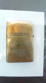
Functional Object - Cigarette Lighter
Gold lighter with inscription and map of Vietnam in a circle.This man is going to Heaven for he has spent his time in Hell here/Vietnam CAM RANH 68-69 Helicopter inscription.zippo lighter, cam rahn -
 National Vietnam Veterans Museum (NVVM)
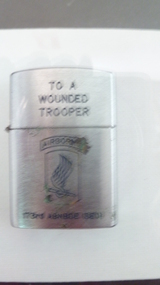
Functional Object - Cigarette Lighter
Silver lighter with inscription and 173rd Airborne graphic.To a wounded Trooper. Unit badge of 173rd Airborne (SED). Penguins, High Quality Lighter & a map of Vietnam.cigarette lighter, 173rd airborne brigade -
National Vietnam Veterans Museum (NVVM)
Booklet, The War Office: Manual of map reading, air photo reading and field sketching, part 1: map reading, 1955 (2 copies)
british armed forces - service manuals -
National Vietnam Veterans Museum (NVVM)
Booklet, The War Office: Manual of map reading, air photo reading and field sketching, part 2: Air photo reading, 1958, 1958
british armed forces - service manuals -
National Vietnam Veterans Museum (NVVM)
Booklet, The War Office: Manual of map reading, air photo reading and field sketching, part 3: Field sketching, 1956 (2 copies), 1956
british armed forces - service manuals -
National Vietnam Veterans Museum (NVVM)
Manual, Manual of map reading, air photo reading and field sketching: part 2: air photo reading, 1958
map reading, air photo reading -
 National Vietnam Veterans Museum (NVVM)
Clothing - Child's jacket, August 1969
Bought by Phil Rogers, Australian Army no. 2790936 during his time of service in South Vietnam (1969-1970) to celebrate the birth of his son.Donated to the museum by the serviceman himself. This commemorative jacket demonstrates the poignant personal sacrifices made by those in service as significant family events continue at home in their absence.Child's bomber-style jacket made of khaki camouflage print polyester, hand embroidered. Purchased in South Vietnam in 1969 by Phil Rogers, Army No:2790936, B Company 6 RAR, and posted home on the birth of his son Brett 31/08/1969.Back: My daddy is in Vietnam/Vung Tau, 69-70/ Viet Nam plus a labelled map of Vietnam. Sleeves: Golden dragons Front: Tiger's head, Crossed South Vietnam flag and USA flag.commemorative clothing, children, family, vietnamese craft, craft, souvenir -
 National Vietnam Veterans Museum (NVVM)
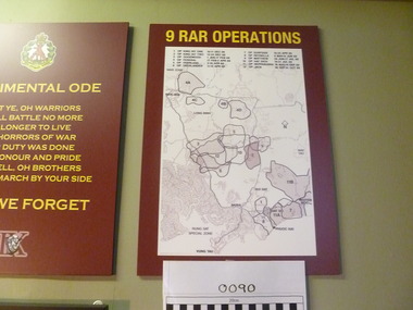
Map, 9 RAR Operations
Maroon coloured board with 9RAR Operations. Map of Vietnam inside a white rectangle are regions mared on with outlines and numbered. Just above the map are numbers and operations, dated, that match the region marked.9RAR Operations 1. King hit one 10-11 Dec 68 2. King hit two 12-24 Dec 68 3. Goodwood 1 Jan-17 Feb 69 4. OP Federal 17 Feb-2 April 69 5. OP Overland 2-10 April 69 6. OP overlander 11-15 April 69 7. OP Surfside 16-23 April 69 8. OP Reynella 8May-15June 69 9. OP Matthew 29 June-17July 69 10. Op hatditch 18-31 July 69 11. OP Neppabunna 18 Aug-15 Sept 69 12. OP Jack 30 Sept-31 Oct 699 rar, map -
 National Vietnam Veterans Museum (NVVM)
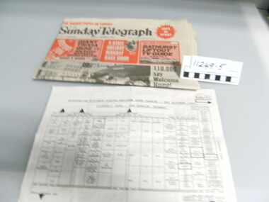
Newspaper
Sunday Telegraph sydney dated 3rd Oct 1987 and a map of assembly area for the Welcome Home Paradenewspaper, welcome home parade -
 National Vietnam Veterans Museum (NVVM)
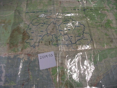
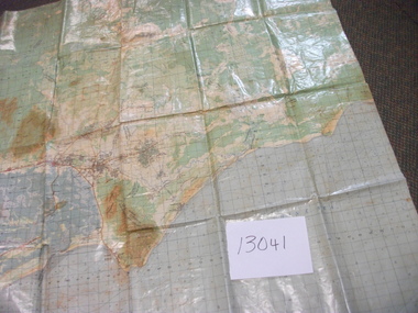
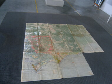
Map, A Contour Map of South Vietnam
A contour map showing ATF Base Patrols.atf base patrols -
 National Vietnam Veterans Museum (NVVM)
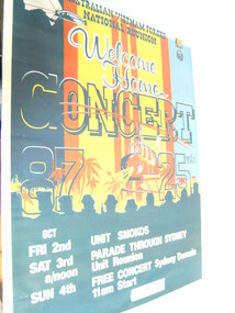
Poster, Welcome Home Concert
Coloured poster with red, blue and yellow print. Army helicopter hovering over palm trees. There is a light shining onto soldiers. Map of Australia with Sydney Harbour Bridge and an Army Medal. In large print are the words "Welcome Home Conert" Date of concert and parade were from the 2nd - 4th October 1987List of activities: Unit Smokos, Parade through Sydney, Unit reunion, Free concert in Sydney Domain, 11am startposter, welcome home parade -
 National Vietnam Veterans Museum (NVVM)
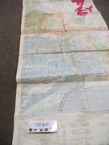
Map, XA BINH BA (SE), 1967
Paper in map in strip form of Vietnam highlighting in red specific area of interest luscombe Field Nui Dat Overprint Information from RA SVY and Intelligence Sources Nov 67map, vietnam, ra svy -
 National Vietnam Veterans Museum (NVVM)
Map, Intelligence Map
Vinyl coated topographical map of part of Vietnam featuring main roads, towns and city locations current or ruined. River locations etc. Names all in Vietnamese language.map, vietnam -
 National Vietnam Veterans Museum (NVVM)
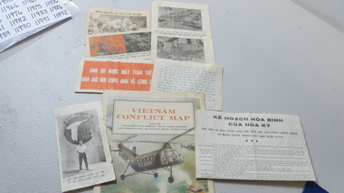
Memorabilia
Various clippings all in Vietnamese language. Large map of vietnam with picture of US Army Helicopter on front: clippings all in Vietnamese: (two depicting dead or injured soldiers, one of flowerw, one of bombs exploding): misc coins of various denominationsEnvelope "Tom, you may be able to use these at the Museum", regards (unable to read writing)memorabilias, vietnamese language -
 National Vietnam Veterans Museum (NVVM)
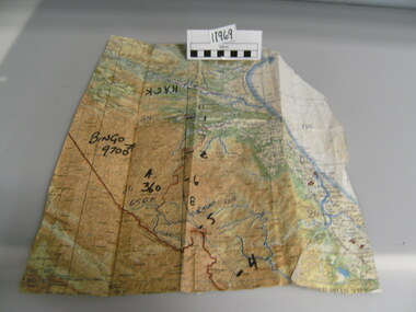
Map
A very damaged well used map which has been jointed together. It appears to be Northern Section of vietnam with numbers written in black texta (Hack, Bingo 9700) on front.On back of map hand written "Mission into the North. Planned both directions".Topagraphical Mapmap, alan reed -
 National Vietnam Veterans Museum (NVVM)
Map
Highly detailed map of Vietnam on parchment from Fwouc Tho Province. Map is waterproof.map, peter lewis -
 National Vietnam Veterans Museum (NVVM)
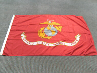
Flag, United States Marine Corps
Red nylon flag featuring yellow and white eagle, standing on a gray round map of the world featuring North and South America in yellow. Large banner on bottom of flag saying "United States Marine Corps" Also around the world globe is an anchor and rope also in yellowUnited States Marine Corpsflag, united states - marine corps -
 National Vietnam Veterans Museum (NVVM)
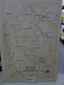
Map, Vietnam in Continental Southeast Asia 1965, 1965
Mounted black and white map of Southeast Asia with country borders and major cities marked. There is a highlight of Phuc Tuy Province in the lower righthand cornerCountries, cities and gulfs anotated map title - Vietnam in Continental Southeast Asia 1965map, phuc tuy -
 National Vietnam Veterans Museum (NVVM)
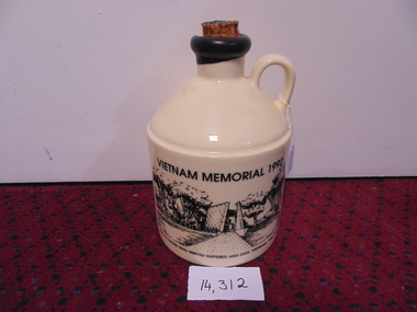
Memorabilia, Port Crock, Vietnam Memorial 1992 (Large)
Front-Vietnam Memorial site- Canberra Reverse- Picture of troops Vietnam- Black and white Side Map of Vietnam For All Those who suffered and died Vietnam 1962-1973Mt Aitken Estates-Australia Picture on reverse- Operation In Vietnamport decanter, vietnam memorial -
 National Vietnam Veterans Museum (NVVM)
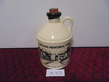
Memorabilia, Port Crock, Vietnam Memorial - 1992 (small)
Front- Vietnam Memorial - Canberra Reverse- Coloured Picture of Troops in Vietnam Side- Map of Vietnam For All Those who suffered and died Vietnam 1962-1973Mt Aiken Estates - Australia Picture on reverse - Operation in Vietnamport decanter, vietnam memorial -
 National Vietnam Veterans Museum (NVVM)
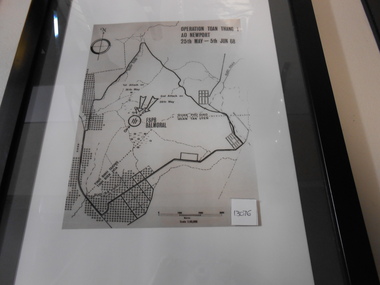
Photograph, Operation Toan Thano 1
Photograph in black frame with inner white matting and outer blackm matting of FSB Balmoral Regional Map.photograph, toan thang, fsb balmoral, battle of coral-balmoral -
 National Vietnam Veterans Museum (NVVM)
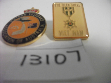
Memorabilia, Badge
Two Badges. One round Vietnam Veterans Association of Australia; black border, gold center with Map and Australian Flag. Crown on top. I've been there VIETNAM with Medal in center. Gold coloured rectangle.badges, vietnam veterans' association of australia -
 National Vietnam Veterans Museum (NVVM)
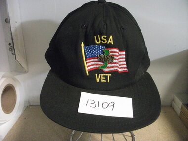
Memorabilia, Peaked Cap
Black material cap with The USA Flag embroidered on front as well as USA VET in yellow cotton. Badge (enamel) featuring Vietnam Veteran in gold over green map.cap, vietnam veterans’ association of america -
 National Vietnam Veterans Museum (NVVM)
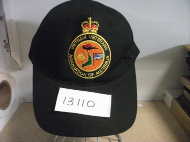
Memorabilia - Peaked cap
Black material Cap with Crown over round gold embroidery "Vietnam Veterans Association of Australia" Centre of cloth badge, orange background with Australia emblem, Map of Vietnam, Australian Flag and Planecap, vietnam veterans association of australia -
 National Vietnam Veterans Museum (NVVM)
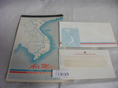
Functional object - Notepad and envelopes
Air mail writing paper with Map of Vietnam, Thailand and Cambodia on front cover. Twelve sheets of lightweight paper. Envelopes: one issued by US Armed Forces - Vietnam Another issued by The American National Red Crossamerican national red cross, us forces, letter, airmail, envelope, writing paper -
 National Vietnam Veterans Museum (NVVM)
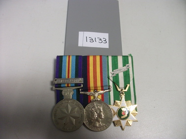
Medal, Medals attached to ribbons
Three Medals attached to ribbons and all backed by perspect. 1. Australian Active Service 1945-1975. Vietnam 2. Elizabeth II Gratia Regina FD 3. 1960 star shaped Medal with map of Vietnammedals, australian army, elizabeth ii