Showing 386 items matching "port melbourne beach"
-
 Mission to Seafarers Victoria
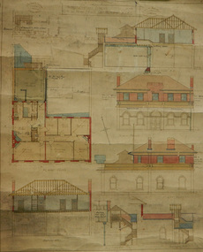
Plan - Architectural drawings, Walter Butler, 1916
... to seafarers chaplains residence beach street nott street port ...An original group of plans drawn by Walter Butler who was also the architect of the Central Institute, Siddeley Street in 1906 and the Mission to Seamen building at 717 Flinders St that is still in use today. The early Port Melbourne onshore Mission gradually transformed from a 'wooden shack' to a one storey brick building designed by architect Frederick Williams in 1888. The St Nicholas chapel was added in 1915. Walter Butler was commissioned to add a second storey in 1917. The building retained its functions until 1937 when the Art Deco Mission, designed by Morris was built. The building has survived as a structure into the 21st century, and was incorporated as part of a multi-apartment development. Historical architectural record of Walter Butler's work. Walter Butler was a renowned architect and friend of the Fairfax family.Coloured architect's drawings of the proposed plans for Chaplain's Residence at Port Melbourne on heavy parchment. Including elevation drawings, floor plans and cross sections as well as architect's notes and measurements.Embossed architect's stamp in top right and left corners and bottom right corner "Walter R Butler [indecipherable] Melbourne" Printer's stamp on bottom right hand corner of rear "Printed by J. Creffield Propy. LTD. RIALTO, 493-5 Collins St. Melbourne"plans, walter richmond butler (1864–1949), mission to seafarers, chaplains residence, beach street, nott street, port melbourne, mission to seamen, frederick williams -
 Mission to Seafarers Victoria
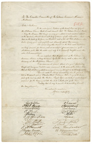
Letter - Petition, October November 1897
... Institute, Beach street, Port Melbourne, would cause the cheering... Institute, Beach street, Port Melbourne, would cause the cheering ...This document reveals the way in which Mission to Seafarers grew in response to demand. With increased shipping to Australia for all purposes, the need for the then existing Mission to grow to be conveniently located and to accommodate seafarers became increasingly evident. This document also shows the formal nature of documents and petitions in the 1890s and documents the names of twenty-two contemporaneous ships and their respective captains. The Anna, Dharwar and Mermerus arrived in port at the end of July 1897. The Carmanina arrived on the 21 October 1897. The Loch Katrine, at the end of the list, arrived on 5 November 1897. The letter was published in the Argus, 22 December 1897: "APPEAL FOR SEAMEN. TO THE EDITOR OF THE ARGUS. Sir, I beg that in the interests of the Victorian Seamen's Mission you will be kind enough to publish the appended testimony of the ship masters who for many years have been trading to this port, and therefore have had many opportunities of judging the effects of his work. The mission has much need of monetary assistance, and, should any of your numenous leaders deem it worthy of support, the committee would feel most grateful for any help that may be given in this direction. It has been the pleasure of the committee as far as possible to supply the crews of all outward bound steamers and sailing vessels with literature for their use on the voyage. My former appeals through your columns for leading matter have always been liberally responded to, and I trust that should any of our booksellers have any surplus stock of periodicals, religious and secular, illustrated or otherwise, at the end of the year, they will kindly remember the Victorian Seamen's Mission and the sailors. Private individuals also who may have stacks of literature by them, if they would kindly send some to the Seamen's Institute, Beach street, Port Melbourne, would cause the cheering of many a dark and lonely hour in the seamen's life. From 900 to 1.200 parcels have hitherto been given to the sailors and firemen annually by this mission, and we should be extremely grateful to those who would place us in a position to continue such donations in the future. Yours, &c. , E. JAMES, Chaplain to the Mission. Seamen's Institute, Beach street, Port Melbourne, Dec. 10." -------------------------------------------------- "To the Executive Committee of the Victorian Seamen's Mission, Melbourne. "Ladies and Gentleman, "We, the undersigned captains of several ships now lying at the Melbourne wharves think it most desirable that the Victorian Seamen's Mission, being the mission that has for so many years shown a most part their interest in the spiritual, moral, and social well-being of the seamen of all nationalities, shall him on the banks of the Yarra an institute such as that at Port Melbourne, where sailors of every grade could profitably and pleasantly spend their evenings. At almost every other seaport in the world such institutions are being provided for seamen, and we are satisfied from our opinion of the Melbourne public that the matter needs only to be prominently brought under their notice to be accomplished. We are confident that the good work of the mission is being hampered by its not having such a place near the shipping at the Melbourne wharves. Our crews are at present placed at a great dis advantage through not having an institute more convenient to the scene of their labours than that at Port Melbourne, which, on a very wet or a very hot, is not easily reached. If a site could be obtained immediately above the Gasworks but on the other side of Flinders street extension, that is to say, on the lower part of the land on which the Harbour Trust offices are built, it would be most convenient for the shipping on both the north and south side of the river. Trusting that it may be possible to do some thing to meet this long felt want, We suscribe ourselves, Yours respectfully, Geo.H Steven, master ship Dharwar; Thos. Curd, master ship Narcissus; James Horne, master ship Loch Garry; T.Tait, master ship Loch Ryan; T. Nilsen, master ship Hebe; G. Ch Christian, master ship Anna; R.E. Peasley, master ship Seminole; Wm. Martin, master ship Loch Ness; T.C. Martin, master ship Loch Tay; W.H. Bennett, master ship Loch Vennachar; J. Raglan Brodie, master s.s. Warrnambool; James E. Coles, master ship Mermerus; J. H. Walker, master ship Hinemoa; R.J. Johns, master ship Ariel; D. Gorchem (sic. Gerckens), master ship Matador; H. Petersen, master ship Nesaia; Wm. J. Reid, master s.s. Star of New Zealand; A. F. Svhanstrom, master ship Hermes; Alex. Smith, master ship Sophocles; W. Y. Bunn, master ship Carmanian; William Anderson, master ship Loch Katrine."This petition is historically significant as it is documentary evidence of the need for a new facility for seafarers signed and presented by the captains of 21 ships, including several of the sister ships of the Loch Ard. The need for a new facility was a result of changes in shipping and the use of the Melbourne ports in the 1890's and this document supported the pressure on the Harbour offices to finally release land for an appropriate building in the early 20th C.Mounted hand-written petition to the Executive Committee of the Victorian Seaman's Mission Melbourne. The letter petitions the Executive Committee to create a facility on the wharves, "where sailors of every grade could profitably and pleasantly spend their evenings." This portion of the letter takes up three quarters of the document. The remainder has two lists, one of twelve captain's signatures and the other of the names of their ships. The list is continued on the reverse side with an additional nine signatures and corresponding ship names.In cursive handwriting: To The Executive Committee of the Victorian Seamans Mission', / Melbourne / Ladies and Gentlemen / we the undersigned captains....... We subscribe / ourselves respectfully, Captain signatures and names of ships ( NB Ship names in upper case for this entry ): Geo H. Stevens - DHARWAR / Thomas Curd - NARCISSUS; / James Horn - LOCH GARRY / T.Tait - LOCH RYAN ; / T.NIlsen - Hebe ; / G.C. Christians - ANNA ;/ R E Peasley - SEMIOLE ; / William Martin - LOCH NESS ; / T C Martin - LOCH TAY;/ W H Bennett - LOCH VENNUACHAR; / RJ Raglan Brodie - SS WARRNAMBOOL; ; / James E. Coles - MERMERUS; / ( signatures continue overleaf) J H Walker - HINEMORA ; / R J Johns - ARIEL; / D Gorchem - MATADOR; / H Petersen - NESAIA;/ William J Reid - STAR of N. ZELAND [sic] ; / TJ Sohanstrom - HERMES;/ Alex Smith - SOPHOCLES; / W Y Bunn - CARMANIAN;./ William Anderson - LOCH KATRINE;/ Handwritten in red ink on the front of the parchment: "8182" NB The second digit in the number sequence appears to have been written over and could also be a "9", an "8" or a "3". paper Watermark "HERCULES". Prior to conservation and taped to the glass on the reverse side of the parchment was a small piece of paper reading: "Letter written in 1897 and signed between the last week of October and the first week of November." T and C probably stands for Trade and Customs and 8382 is the file no." (H8.4 x W11.8)victoria, melbourne, ships, petition, australia-wharf, captains, signatures, 717-flinders-street-docklands, maritime welfare services, mission to seafarers, seamen's mission, mission to seamen, mermerus, captain coles, sir john coode, loch line, loch ness, loch gary, loch ryan, ss warrnambool, loch tay, loch vennachar, matador, nesaia, d. gerckens, h. petersen, a.f. svhanstrom, hermes, ariel, loch katrine, william anderson, dharwar, narcissus, hebe, anna, hinemoa, sophocles, carmanian, captains' petition -
 Flagstaff Hill Maritime Museum and Village
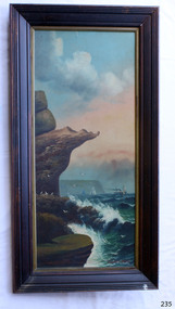
Painting - Oil painting, W. Langley-Taylor, Eagle Rock, Warrnambool, Vic, Late 19th to early 20th century
This painting is one of a pair of large paintings by W. Langley-Taylor in our collection. Currently, no further information has been found about the artist but research is ongoing. The subjects of these paintings are seascapes of notable areas of the coast on each side of Port Phillip Bay, south of Melbourne, Victoria. This painting is of Eagle Rock, Warrnambool, which is on the west of Port Phillip Bay. Eagle Rock is located about 400 metres west of Thunder Point, near Shelly Beach. The painting includes the rocky cliff formations looking east towards the Warrnambool Breakwater. The walk from the Thunder Point car park westwards to Shelly Beach has been popular over the decades with residents as well as tourists. Many photographs include the rock, with varying backgrounds depending on the angle of the camera. It is a popular dive site for locals and visitors, in calm weather! The site can be approached by boat from the open sea in favourable conditions, and there is plenty of native marine to be seen in this marine sanctuary. This part of Warrnambool’s rugged coastline is unprotected from the Southern Ocean with its wild icy winds and high seas. The painting’s crashing waves and the northerly direction of the smoke on the steamship sailing north show the effect of the southerly wind. INSCRIPTIONS “Mrs M Irby” and “980/Regency” The significance of the inscription “Mrs M Irby”, on the back of each of the two paintings, has not yet been discovered. Perhaps she was connected with the ship or shipping company “Irby”. A ship named “Irby”, built in Merseyside, Liverpool in 1881 by R & J Evans, Birkenhead. It was a four-masted iron ship built for the White Star Line. Henry Wilson Hewitt bought her in 1882, then later she was owned by Chadwick & Pritchard. In 1888 she was registered under the Irby Ship Co. Ltd. (trading as J. Joyce) in Liverpool. In 1912 Galgate Co. Ltd owned her. She traded between London, England and Australia, and is recorded as being in Melbourne and Hobart. In 1919 the Irby was destroyed by a mine when on her way to England. Or perhaps her name and the inscription in pencil “980/Regency” on the Eagle Rock Warrnambool, painting could be a delivery address for the paintings, perhaps an apartment in a hotel. This painting is significant geographically for its representation of the coastal scenery of Victoria, Australia. It is also significant as one of a pair of paintings of seascape, one at sites each side of Port Phillip Bay. The painting is significant historically as an example of late 19th and early 20th methods and materials used to construct a painting’s frame. Painting oil on board in a dark wooden frame, portrait orientation. Seascape of rock formation and cliffs, two yachts, a two-masted steamboat with red funnel and smoke, flying birds, high waves breaking onto rocks, blue sky with clouds, some tinted pink.. The title is painted on lower left corner and the artist, W. Langley-Taylor, has signed his name on lower right. The inscription on the back is a handwritten script in red crayon or thick red pencil. The board is held in place inside the timber frame with small, dark metal tacks around all sides. Metal eyes join the wire to the frame. Small round, dark metal nail heads are dispersed around the frame and there is a change of colour on both the board and the wood of the frame. Painted on front “W.LANGLEY-TAYLOR.” and “EAGLE ROCK, WARRNAMBOOL, VIC.” Handwritten on back “Mrs. M. Irby” and “980 [underlined] Regency”flagstaff hill, warrnambool, shipwrecked coast, flagstaff hill maritime museum, maritime museum, shipwreck coast, flagstaff hill maritime village, great ocean road, eagle rock warrnambool, w. langley-taylor, oil painting, wall decoration, seascape of victoria's coast, mrs m irby, art, seascape, pair of paintings -
 Federation University Historical Collection
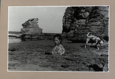
Photograph - Photograph - Black and White, Point Lonsdale, Victoria; Back Beach below the Lighthouse - Girl with a Dog
Work produced during Paul Lambeth's photography class The photograph shows the back beach at Point Lonsdale, below the Point Lonsdale Lighthouse. This area was where many sailing ship coming to Melbourne were wrecked. This was due to the narrow passage through The Rip and the tides at certain times. A Pilot Station was established and ship captains could signal for a Pilot to steer them through The Rip and into Port Philip Bay. Black and white photograph adhered to a beige coloured mount card showing a girl down a hole in the sand with her dalmation dog sitting in a rock pool.paul lambeth, point lonsdale, back beach, sailing ships, ship wrecks, the rip, port philip bay, pilot station, girl, dalmation dog -
 Flagstaff Hill Maritime Museum and Village
Document - Plans, Lighthouse Keeper's Quarters Warrnambool, 1858-1909
The set of seven 1858 plans shows proposed plans for the original Lighthouse Complex that was built on Middle Island in 1858-1859. The whole complex was then transferred to Flagstaff Hill in 1871. The plan, dated 1909, is for proposed additions and repairs to the Quarters at Flagstaff Hill. The plan 'Alterations and Additions' shows alternate plans for changes to the quarters at the Flagstaff Hill location. This plan has no date. The Complex comprised the Lighthouse, the Lighthouse Keepers’ Quarters, the Store (now called the Chart Room) and a Privy, which was not included in these plans. The Keeper’s bluestone Quarters was a cottage divided into two compartments, one for each keeper and his family. The bluestone Store was divided into three; a store, a workshop an oil store (or office). The Privy comprised of a small building also divided into two separate, back-to-back toilets, one for each Keeper and his family. The Flagstaff Hill Keeper's Quarters have had extensions and additions at various times, and these have also been removed at various other times. THE PLANS - *Dec. 1858 (12/58) ‘Lighthouse Keepers Quarters No.2 Warrnambool’ (2375.01)* Public Works Office Melbourne – Front and Back elevations, sections, and floor plan. The drawing shows timber walls. [The floor plan is the closest plan to the current building, however, the walls are timber in this plan.] *Nov. 1858 – No.3 ‘Lighthouse Keepers Quarters Warrnambool’ (2375.02)* Office of Public Works, Melbourne – Back and End elevations and section through. The drawing shows stone walls. One side; Senior Keeper’s bedroom, living room and kitchen with storeroom. Another side; is the Assistant’s bedroom, living room and storeroom. *Nov. 1858 - No.4 ‘Lighthouse Stores Warrnambool’ (2375.03)* Office of Public Works – Front, Side and end elevations, centre section. The drawing shows stone walls. *Nov. 1858 – No.4, ‘Lighthouse Stores No. 2 Warrnambool’ (2375.04)* Office of Public Works – Front, side and end elevations, centre section. The drawing shows timber walls. *Nov. 1858 – ‘Details Lighthouse Keepers Quarters No. 2 Warrnambool’ (2375.05)* Public Works Office Melbourne. The plan shows the foundations, joists and eaves. The drawing shows timber walls. (Nov. 1858 – ‘No.4 ‘Lighthouse No. 2 – Warrnambool’ (2375.06)* Public Works Melbourne (Part of the paper is missing). This plan shows an octagonal tower, internal stairs, a balcony landing, and a weather vane on top. *November 1858 – No. 1, ‘Lighthouse – Warrnambool’ (2375.07)* Office of Public Works Melbourne. This plan shows a round tower, including the stairs, windows on the tower and the weather vane on the top. *4/3/9 [1909] – ‘Additions and Repairs, Lighthouse Quarters, Warrnambool, General Plan’ (2375.8)* Department of Public Works Melbourne’s official stamp is signed by Croft. It shows the floor plans of the Store, Upper Lighthouse and the Quarters. The Store building has three sections; a Store, Work-Shop and Office, with an internal wall between them and separate entries. The Quarters are divided into two dwellings. The Senior Keeper’s side on the left has fireplaces in two of the three bedrooms and there is a pantry and wash house. The Assistant’s side has no fireplaces in the bedrooms and there’s no pantry or washhouse. These plans include proposed changes to the buildings. The Senior Keeper’s Quarters would have a partition on bedroom 2, a bath with plumbing and drainage, a wall moved and a built-in side porch. The Store would also have a built-in porch. The undated plan 'Additions and Alterations' (2375.9) shows alternative arrangements for water tanks, plumbing and such. WARRNAMBOOL'S LADY BAY LIGHTHOUSES- In the 1800s ships sailing from England to Australia began to use Bass Strait as a faster route to Melbourne. Small navigation errors led to many tragic shipwrecks. From 1848 lighthouses were operating along Victoria’s southern coast as a guide for sailors. Coastal towns such as Warrnambool grew and the exchange of trade and passengers were of great benefit. However, the uncertain weather changes, relatively shallow waters and treacherous, hidden rocky reefs were not suitable for a Harbour and in the 1840s and 1850s there were many shipwrecks in the area, with some even stranded in its Lady Bay harbour. A jetty was built in 1850 and a flagstaff to guide seafarers was placed up high on what became known now as Flagstaff Hill. In November 1857 the Victorian Government recommended that Warrnambool Harbour had beacons and two lighthouses to guide vessels into and out of the Harbour safely. The white light of the Middle Island lighthouse was to be used for the first time on September 1, 1859. The red light of the Beach Lighthouse, a wooden obelisk structure, was first operated on March 25, 1860, but in 1868 this light was ‘discontinued’ due to it being too low. Melbourne’s Department of Public Works decided to relocate the Middle Island Lighthouse Complex - Lighthouse, Keeper’s Quarters, Privy, Store Room and even water tanks - to Flagstaff Hill. The lower obelisk was shortened, and a protruding gallery, railing, and external ladder were added, as well as the light from the Beach Lighthouse. A green guiding light was erected on the end of the jetty. The transfer of the Complex began in March 1871. Each shaped stone of the lighthouse was carefully numbered, removed then reassembled on Flagstaff Hill. In 1872 the well was sunk behind the Lighthouse Keeper’s Cottage. The Keepers and families had left Middle Island in April and moved to Flagstaff Hill in October 1871. Vessels entering Lady Bay align the Upper and Lower Lighthouse towers during the day and the lights at night. The Upper Lighthouse is a round tower, the Lower Light is square. The Lighthouses were categorised as harbour lights rather than coastal lights, so they remain under the control of the Victorian Government’s Ports and Harbours section. The lights were originally powered by oil, then acetylene gas, later by electricity, and then converted to solar power in 1988. In 1993 the solar panel was replaced by a battery charger. A decision was made in 1936 to replace the lighthouses’ lights with unattended lights that no longer required Keepers and Assistants. At least 29 Keepers had attended to the lighthouse from its opening in 1859 to when the last official Lightkeepers left In April 1916. The Warrnambool Harbour Board rented out the Quarters from 1916 to 1936. The Board closed down but the rentals continued with other unknown landlords. In the 1970s the Flagstaff Hill Planning Board was set up under the chairmanship of John Lindsay. The Board was to make recommendations to the Warrnambool City Council regarding the use of the buildings and the rest of the Crown Land on the site. The Flagstaff Hill Maritime Village opened in 1975 and began renovating the Cottage in stages, during which time evidence of a 1920s fire was found in the eastern section of the cottage. Additions of a porch on the west and a washroom on the east were made in the 1980s. The western part of the building is now a Shipwreck Museum and the east has returned to a late 19th-century Lighthouse Keeper’s cottage and includes the screen made by Assistant Lighthouse Keeper Thomas Hope during one of his two periods of service there. THE LIGHTHOUSE KEEPERS Lighthouse Keepers were responsible for keeping their Lighthouse’s lights shining at night. They kept a lookout for passing vessels and changes in weather. They were expected to clean, polish and maintain the equipment and buildings. They kept regular and detailed records of who was on watch, and the time the light was lit, trimmed and extinguished. They kept a journal about other events that occurred. They keep regular, accurate Meteorological Logs. It was expected that they were competent in Morse code signalling. They would be called to help in times of disasters and shipwrecks, and to give official statements about these events. Many Lighthouse Keepers also volunteered as members of the lifeboat crew. The Lady Bay lighthouses were officially classified as small, so the Keepers had the official titles of Senior Assistant Lighthouse Keeper and Assistant Lighthouse Keeper. They were employed by the Public Service and paid rent to live in the Lighthouse Quarters. They were compulsorily retired at the age of 60, with most receiving a superannuation payment. Despite their time-consuming duties, there was time to follow hobbies and crafts such as growing vegetables, playing musical instruments, making models of buildings including lighthouses, and crafting furniture pieces. An example of a keeper’s skills is the carved fire screen made by /assistant Keeper Thomas Hope in the early 20th century and displayed in the Lighthouse Keeper’s cottage at Flagstaff Hill. The last occupants of the Middle Island Complex were Senior Keeper Robert Deverell, his Assistant Keeper, Andrew Farncombe, and their families. They all became the first occupants at the Lady Bay Lighthouse Keepers’ Quarters on Merri Street. The Warrnambool Lighthouse Complex plans are the origin of what is now the Lady Bay Lighthouse Complex. They are a record of the people, process and departments involved in bringing the complex into fruition. The plans are significant to the Complex, which is now listed on the Victorian Heritage Register, H1520, for being of historical, scientific (technological) and architectural significance to the State of Victoria. The Complex is significant as an example of early colonial development. The plan are significant for their connection with the important navigational function of the Lighthouses, a function still being performed to this day. The plans are also significant as an example of a product from the Public Works Department in Victoria in the mid-to-late 19th century. The structures built to these plans still stand strong. Plans for the Lighthouse Complex in Warrnambool, including Lighthouses, Keeper's Quarters and Stores. Seven of the plans are on thin fragile paper, one is on thicker, stronger paper. The drawings have been made in pens coloured red and black. They originate from Public Works in Melbourne. Seven were drawn in 1858, one in 1904, the other is not dated.Dec. 1858 - Lighthouse Keepers Quarters No.2 Warrnambool. Public Works Office Melbourne. Nov. 1858 - No.3 ‘Lighthouse Keepers Quarters Warrnambool. Public Works Office Melbourne. Nov. 1858 - No.4 ‘Lighthouse Stores Warrnambool. Office of Public Works. Nov. 1858 - No.4, ‘Lighthouse Stores No. 2 Warrnambool. Office of Public Works. Nov. 1858 - Details Lighthouse Keepers Quarters No. 2 Warrnambool. Public Works Office Melbourne. Nov. 1858 - No.4 ‘Lighthouse No. 2 – Warrnambool. Public Works Melbourne. Nov. 1858 - No. 1, Lighthouse - Warrnambool. Office of Public Works Melbourne. 4/3/9 [1909] - Additions and Repairs, Lighthouse Quarters, Warrnambool, General Plan. Department of Public Works Melbourne. SIGNED "Croft" "15A" on reverse [no date] - Lighthouse Quarters Warrnambool, Additions and Alterations. "9A" on reverseflagstaff hill, warrnambool, lighthouse keeper's cottage, lighthouse residence, lighthouse, plans, public works, melbourne, flagstaff hill maritime museum, maritime museum, shipwreck coast, flagstaff hill maritime village, chart room, quarters, privy, middle island, beach lighthouse, obelisk, lighthouse keeper, assistant keeper, lighthouse complex, lady bay, lady bay complex, keepers, upper lighthouse, lower lighthouse, ports and harbours, cottage, harbour board, flagstaff hill planning board, meteorological record, robert deverell, andrew farncombe, warrnambool port, warrnambool harbour, residence, alterations, repairs, department of works -
 City of Moorabbin Historical Society (Operating the Box Cottage Museum)
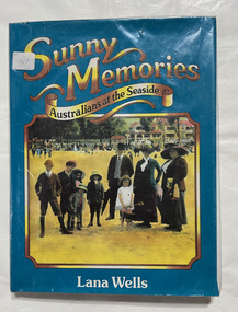
Book, Wells, Lana, Sunny memories : Australians at the seaside, 1982
Leisure activities. Social aspects. Australia. Beaches, to date183 p. : ill. (some col.), ports.Leisure activities. Social aspects. Australia. Beaches, to daterecreation, leisure, bathing customs, australia -
 Flagstaff Hill Maritime Museum and Village
Equipment - Lifebuoy
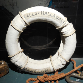
This lifebuoy is part of the lifesaving equipment from the sailing ship the Falls of Halladale. It is filled with cork and covered with canvas and reinforcing bands. The name of the ship and its origin is printed on the lifebuoy. It has been sealed with several coats of white paint. A lifebuoy, or life-preserver, is used as a buoyancy device to keep a person afloat in the. It is usually connected by a rope to a person in a safe area such a nearby vessel or on shore. The lifebuoy is thrown to a person in distress in the water, allowing the rescuer to pull the person to safety. The lifebuoy is a made from a buoyant material such as cork or rubber and is usually covered with canvas for protection and to make it easy to grip. The first use of life saving devices in recent centuries was by the Nordic people, who used light weight wood or cork blocks to keep afloat. From the early 20th century Kapok fibre was used as a filling for buoys. Light weight balsa wood was used as a filler after WW1. In 1928 Peter Markus invented and patented the first inflatable life-preserver. By WW2 foam was combined with Kapok. Laws were passed over time that has required aeroplanes and water going-vessels to carry life-preservers on board. The Falls of Halladale 1886-1908 The vessel ‘Falls of Halladale’ was a four-masted iron-hulled barque, launched in July 1886, by Russell & Co of Greenock, Scotland and owned by the Glasgow Falls Line, which named its ships after Scottish waterfalls. The ship was built for long distance cargo trade. The Falls of Halladale was one of the last windjammers that sailed the Trade Route. The ship was on its way from New York to Melbourne via the Cape of Good Hope when, after 102 days at sea, its journey suddenly ended. During the night of November 14, 1908, in calm seas with some coastal fog, an ocean swell raised the vessel up then let it down on a submerged reef wrecked at Curdies Inlet, Peterborough. The ship was stranded and the Port Campbell Rocket Crew were sent for, to perform a rescue. However by the time they arrived, all on board had already travelled by lifeboat to the nearby beach at the Bay of Islands. The sight of the slowly disintegrating ship on the rocks attracted many sightseers. This lifebuoy is significant for its association with the famous ship the Falls of Halladale. It is significant for its association with lifesaving equipment used on board vessels in the early 20th century. The Falls of Halladale shipwreck is listed on the Victorian Heritage Register (No. S255). She was one of the last ships to sail the Trade Routes. She is one of the first vessels to have fore and aft lifting bridges. She is an example of the remains of an International Cargo Ship and also represents aspects of Victoria’s shipping industry. The wreck is protected as a Historic Shipwreck under the Commonwealth Historic Shipwrecks Act (1976).Lifebuoy; round white canvas ring, joined with hand stitching. Stencil with inscription is printed in black on first and third quadrant. The canvas has been repainted in white but avoiding the inscription in the lifebuoy. A hanging board for display is attached with white rope. Lifesaving equipment from the Falls of Halladale.“FALLS OF HALLADALE” “GLASGOW”flagstaff hill, warrnambool, shipwrecked coast, flagstaff hill maritime museum, maritime museum, shipwreck coast, flagstaff hill maritime village, great ocean road, life rings, lifebuoy, safety ring, life-saving buoy, ring buoy, life preserver, personal floating device, floatation device, safety equipment, falls of halladale, glasgow falls line, rocket crew, lifeboat, peterborough -
 Port Melbourne Historical & Preservation Society
Photograph - Williamstown ferry, Gem, Railway Pier, Port Melbourne, c. 1900
Photo of "GEM", a Williamstown ferry (in foreground), a number of sailing ships in background, and children playing on the beach. Railway Pier.transport - shipping, gem -
Port Melbourne Historical & Preservation Society
Photograph - Tower, Missions to Seamen, Port Melbourne, Alison Kelly, 1995
Photo of tower, Port Melbourne Missions to Seamen building, 1 Beach Road1988missions to seamen -
Port Melbourne Historical & Preservation Society
Pamphlet - Beach to Borough: Liardet's Beach and Early Sandridge 1994, Pat Grainger, Walks around Vintage Port No.1, Nov 1994
Tourism pamphlet produced in time for the visit of the Replica Endeavour to Station Pier, Nov/Dec 1995. Print cost sponsored by The Anchorage.Port Melbourne Historical and Preservation Society publication, "Walks around Vintage Port", No.1 Beach to Borough: Liardet's Beach and Early Sandridge, 1994 edition. built environment, wfe liardet, wilbraham frederick evelyn liardet -
Port Melbourne Historical & Preservation Society
Plan - Subdivision of area bounded by Nott Street, Rouse Street, Beach Street, Port Melbourne, Block Number 2067, 1884
... , Beach Street, Port Melbourne... Street, Rouse Street, Beach Street, Port Melbourne ...Copy of plan of area bordered by Nott Street, Rouse Street, Beach Street, showing subdivision of land with relevant property owners (HB DONALDSON, J NOLAN, J Hill and Sons, GW ROBINS, Carl ECKBURG, JM SMITHSON, J WALLACE) Block number 1, Port Melbourne 1884, Block number 20.67. Water Mark on Paper "J Whatman 1883"built environment - domestic, j whatman, henry beveridge donaldson, j nolan, j hill and sons, g w robins, carl eckburg, j m smithson, j wallace -
 Port Melbourne Historical & Preservation Society
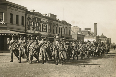
Photograph - 13th Field Artillery Brigade, Beach Street, Port Melbourne, 1915
... 13th Field Artillery Brigade, Beach Street, Port Melbourne.... The Brigade is shown marching up Beach Street, Port Melbourne.... The Brigade is shown marching up Beach Street, Port Melbourne ...Bill did not return from the war. More information in "World War One - a history in 100 stories" by Bruice Scates, Rebecca Wheatley and Laura James.Black and white photo of William Johnstone Knox (Bill), Lieutenant (later Captain) 13th Field Artillery Brigade, World War I. The Brigade is shown marching up Beach Street, Port Melbourne, probably 28.06.1915 (the date of sailing). Bill is at the front on the left hand side of the march. (RHS of photo) Photo shows Beach St commercial buildings.built environment - commercial, war - world war i, william johnstone (bill) knox, harper's starch factory, bayview hotel -
Port Melbourne Historical & Preservation Society
Photograph - Demolition of Swallow & Ariell Beach Street end and development of Anchorage apartments, Port Melbourne, Ron Laing, 1994 - 1996
Part of Ron Laing's collection of photographs recording Port Melbourne over a thirteen year period. Donated to the PMH&PS by the photographer.A set of 38 colour photographs covering the demolition of the old Swallow & Ariell biscuit factories at the Beach Street end of the site, and development of the Anchorage apartment buildingsbuilt environment - domestic, ron laing -
 Port Melbourne Historical & Preservation Society
Photograph - Civic structures, Port Melbourne, Ron LAING, Ron Laing, 1986 - 1999
Part of Ron Laing's collection of photographs recording Port Melbourne over a thirteen year period. Donated to the PMH&PS by the photographer.A set of 37 colour photographs of Port Melbourne civic stuctures, 1990s, including the Town Hall, Liardet Community Centre, Freemasons' Hall, RSL Club (Excelsior Hall), old fire station, 1910 Post Office, 1860 Post Office and Naval Drill Hall, Metropolitan Fire Station, Police quarters, Police Station and Court House, Nott Street State School, Graham Street State School, St Joseph's Primary School and Rotunda in Beach Streetbuilt environment - civic, ron laing, nott street state school, graham street state school, port melbourne primary school, port melbourne town hall, liardet community centre, excelsior hall, freemasons hall, fire station, post office, naval drill hall, police station, st josephs catholic primary school, band rotunda -
Port Melbourne Historical & Preservation Society
Photograph - Light rail line extenion over Beach Street, Port Melbourne, Ron Laing, c. 1996
... Light rail line extenion over Beach Street, Port Melbourne... Photograph Light rail line extenion over Beach Street, Port Melbourne ...Part of Ron Laing's collection of photographs recording Port Melbourne over a thirteen year period. Donated to the PMH&PS by the photographer.Colour photographs of the extension of the light rail line over the new Beach Street at the old train stationtransport - tramways, built environment - domestic, beacon cove, ron laing -
Port Melbourne Historical & Preservation Society
Photograph - Various aircraft, Ron Laing, 1990s
... in Port Melbourne, 1990s... at the beach in Port Melbourne, 1990s Photograph Various aircraft Ron ...Part of Ron Laing's collection of photographs recording Port Melbourne over a thirteen year period. Donated to the PMH&PS by the photographer.A set of 22 colour photographs on flight, including Whitman's air ship, aircraft over Avalon Air Show, helicopters - both flying advertising flags and on the ground at the beach, and several hot air balloons and their near misses at the beach in Port Melbourne, 1990stransport - aviation and aerodrome, celebrations fetes and exhibitions, ron laing -
Port Melbourne Historical & Preservation Society
Photograph - Various Port Melbourne locations, Jun 1985
Part of Ron LAING's collection of photographs recording Port Melbourne over a thirteen year period. Donated to the PMH&PS by the photographer.Ron LAING photographs .01 - photo taken from a vessel at Station Pier, June 1985. Showing the Port Melbourne foreshore before the old yacht club fire and the building of the high rises. .02 & .03 - photos taken on the corner of Albert and Poolman Streets comparing the scene ten years apart .04 - photo of the Port Melbourne foreshore after demolition of Centenary Bridge, but before the coming of the high rises.built environment - civic, natural environment - beaches and foreshore, piers and wharves - station pier, port melbourne yacht club, pmyc -
Port Melbourne Historical & Preservation Society
Book, Graham Patterson, "Coastal guide to nature and History Port Phillip Bay", 2013
... Port Melbourne Historical & Preservation Society Port ..."Coastal guide to nature and History Port Phillip Bay" Book with coloured photograph of rock and coastline on cover.natural environment - beaches and foreshore, natural environment, conservation, piers and wharves - railway pier, piers and wharves - station pier, piers and wharves - princes pier, coastal, port phillip bay, centenary bridge, beacons, robert harper & co ltd, liardet family -
Port Melbourne Historical & Preservation Society
Newspaper - Articles re burst water main in Liardet Street, Port Melbourne, 17 Dec 2014
In the early hours of Tuesday 16 December, 2014 a water main burst in Liardet St. The resulting sink-hole swallowed two cars and left a massive hole which took 8 days to repair and re-open the road. Several houses on the city side of Liardet St suffered water damage and water also entered the underground car park of the apartment block on the beach side.Newspaper clipping from "the Age" Wednesday, December 17, 2014. Also from Glen Eira /Port Phillip Leader, Tueday December 23 2014built environment - domestic, engineering - roads streets lanes and footpaths, engineering - canals and drainage, liardet street, water supply -
 Port Melbourne Historical & Preservation Society
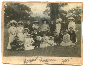
Photograph - Robert Harper & Co picnic, 1908
Robert Harper & Co had an industrial complex on Beach Rd from Sandridge lagoon to Post Office Place. A wide variety of goods were produced including rice, starch, spices, cocoa, flour, spices, oatmeal, jelly crystals. Most of the complex was demolished around 1980 but some buildings have been transofmed into apartment blocks.Digital copy of Black and White photo mounted on card with the words "Harpers Picnic 1908" written below. The group of twenty two (22) includes two young children and the whole group are dressed in their finery and one man in the centre appears to be playing the piano accordion. The location of the bushland setting is unknown.social activities, industry - food, industry - manufacturing, robert harper & co ltd -
Port Melbourne Historical & Preservation Society
Document - CD-ROM, City of Port Phillip, City of Port Phillip. Sandridge Beach master Plan, Feb 2003
City of Port Phillip. Sandridge Beach master Plan. Plastic Cd case with white disc. There is a hard copy of the plan in the vertical files in room A behind the door. Filed with Beacon Cove materialCity of Port Phillip. Sandridge Beach Master Planbuilt environment, local government - city of port phillip, sandridge beach -
Port Melbourne Historical & Preservation Society
Photograph - Station Pier, Port Melbourne, Lyn Allison, Mar 1993
Colour photograph showing Station Pier with West kiosk still in original location and some foreshore work in progress taken 8th Match 1993. In the foreground a sheoak (casuarina species) is visible and is of interest as it is still there in 2015 after so much change has occurred in the area (opposite 1-11 Waterfront Place)piers and wharves - station pier, natural environment - beaches and foreshore, abel tasman -
Port Melbourne Historical & Preservation Society
Document - DVD, Public Records Office Victoria (PROV), Seamen's Mission (230 Rouse St) Port Melbourne, Public Building file, 1906
NB this does not relate to the Beach and Nott Institute, but to a separate one from Temperance Hall that leased premises in 1906COPYRIGHT PROV Seamen's Mission (230 Rouse St) Port Melbourne, Public Building file. DVD containing 14 pages of images of documents between Rev B Cozens and the Public Health Department regarding conversion of four rented rooms into a Seamen's Mission at 230 Rouse St, Port Melbourne in 1906built environment, transport - shipping, missions to seamen, societies clubs unions and other organisations, rev b cozens -
 Port Melbourne Historical & Preservation Society
Photograph - Harper's Buildings, Port Melbourne, Janet and Allen Walsh, Janet and Allen Walsh, Harpers building Beach St, 1973
Shot in 1973 with particular interest in architectureSome Harper's factory buildings on Beach St. 1973Identified and dated on back in inkbuilt environment - commercial, built environment - industrial, robert harper & co ltd -
Port Melbourne Historical & Preservation Society
Photograph - HMAS development, Beach Street, Port Melbourne, 2012
... HMAS development, Beach Street, Port Melbourne... development, Beach Street, Port Melbourne ...Photographic images of properties in Port Melbourne. Image may have been taken by a PMHPS member or scanned from a past resident or taken for real estate sale purposes. Beach Street - Windows and balconies detail from HMAS development (January 2012) built environment - domestic, beach street, hmas -
Port Melbourne Historical & Preservation Society
Photograph - Beach Street, Port Melbourne, 2012
... Beach Street, Port Melbourne... Beach Street, Port Melbourne ...Photographic images of properties in Port Melbourne. Image may have been taken by a PMHPS member or scanned from a past resident or taken for real estate sale purposes. Beach Street - Photo taken from beach showing beachfront and Beach St redevelopment and rotunda in 2006 built environment - domestic, natural environment - beaches and foreshore, beach street, hmas apartments, band rotunda -
 Port Melbourne Historical & Preservation Society
Photograph - Lee-ar-day Days, 160th anniversary of the Liardet landing, Nov 1999
... and at the Port Melbourne Yacht Club in November 1999 by the PMH&PS...Port Melbourne Historical & Preservation Society Port ...49 colour photographs taken at the 'Lee-ar-day Days' celebrations, a two-day festival held on Liardet's Beach and at the Port Melbourne Yacht Club in November 1999 by the PMH&PS for the 160th anniversary of the Liardet landing. (Some negatives are held in A.06.05.B10)celebrations fetes and exhibitions, liardet family, port melbourne historical & preservation society, pmhps, wilbraham frederick evelyn liardet, wfe liardet -
 Port Melbourne Historical & Preservation Society
Photograph - Lee-ar-day Days, 160th anniversary of the Liardet landing, Nov 1999
... and at the Port Melbourne Yacht Club in November 1999 by the PMH&PS... on Liardet's Beach and at the Port Melbourne Yacht Club in November ...72 black and white photographs taken at the 'Lee-ar-day Days' celebrations, a two-day festival held on Liardet's Beach and at the Port Melbourne Yacht Club in November 1999 by the PMH&PS for the 160th anniversary of the Liardet landingcelebrations fetes and exhibitions, liardet family, port melbourne historical & preservation society, pmhps, wilbraham frederick evelyn liardet, wfe liardet -
Port Melbourne Historical & Preservation Society
Book, Meyer Eidelson et al, Walks in Port Phillip - A guide to the cultural landscapes of a city, Jan 2001
Book produced under a Federation grant. Five of the trails are associated with benches located on the foreshore.'Walks in Port Phillip - A guide to the cultural landscapes of a city' by Meyer EIDELSON. Small blue soft-cover book with seven guided walks and maps. 2001. 82pp with fold-in back coverSigned by author on title page 'Meyer'piers and wharves - station pier, immigration, piers and wharves - lagoon pier, utilities - gas, swallow & ariell ltd, natural environment - beaches and foreshore, natural environment - lagoon, liardet family, australian aborigines, meyer eidelson, vincenzo coluccio, rosa coluccio, pat grainger, gasworks -
Port Melbourne Historical & Preservation Society
Photograph - Port Melbourne's changing waterfront, Ron Laing, 1999
Part of Ron Laing's collection of photographs recording Port Melbourne over a thirteen year period. Donated to the PMH&PS by the photographer.A set of 34 colour photographs of Port Melbourne's changing waterfront, covering the old and new harbor control tower on Fishermens Bend, restoration of the outer beacon, reconstruction of the west wing of Station Pier, demolition of the concrete 'steps' breakwater at Port Melbourne, reconstruction of the foreshore - Sandridge Beach to Beacon Roadbuilt environment, natural environment, demolitions, piers and wharves, ron laing