Showing 247 items
matching post and rail
-
 Hume City Civic Collection
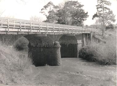
Photograph, Early 1970s
The Macedon Street Bridge over Jacksons Creek is important because it was built on one of Victoria's first important roads. It replaced a smaller lighter bridge in 1857 and continued to be used until the early 1970s.A black and white photograph of a two arched bluestone bridge over a creek. A wooden post and rail fence painted white has been constructed in front of the original stone wall of the bridge.bridges, bluestone bridges, jacksons creek, macedon street, george evans collection -
 Clunes Museum
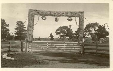
Postcard - PHOTOGRAPH, CLUNES CENTENARY, 1939
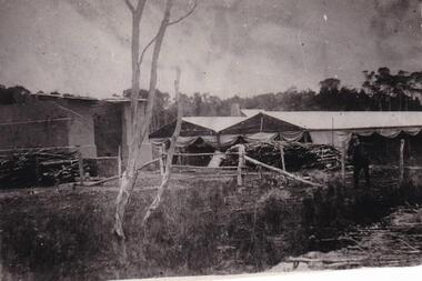
PHOTOGRAPH /POSTCARD - DECORATED ENTRANCE TO A PROPERTY FOR CLUNES CENTENARY 1839 - 1939 POST AND RAIL FENCE. WHITE WOOD GATE WITH DECORATED FRAME HOME WITH HAY STACKS, PINE AND GUMTREES IN BACKGROUND.photography, events and celebrations, back to clunes, centenary -
 Lakes Entrance Historical Society
Postcard - The Entrance at Lakes Entrance, Murray Studios Gympy Qld, 1930 c
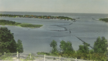
Also a second hand colourewd postcard of similar view showing navigation light on right side of photo 05366.1 6.5 x 10 cmColoured postcard showing view of houses at the entrance and New Works buildings and western end of Bullock Island and rock groynes. Post and rail fence on Jemmys Point Lakes Entrance VictoriaMurray views No 32 A picture view of the Entrance at Lakes Entrancewaterways, islands -
 Malmsbury Historical Society
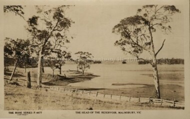
Postcard (Item), "Postcard Head Of The Reservoir Malmsbury, Rose Series P4677", Malmsbury c1927
Associated with - Rose Series P4677 Buildings - Post & Rail Fence People - Jessie Swainston Collection -
 Lakes Entrance Historical Society
Postcard - Lakes Entrance viewed from Jemmys Point, Rose Series, 1925 c
Post and rail fence beside highway and no vegetation on sand dunes eastern part of Cunninghame ArmBlack and white postcard showing view of Cunninghame Arm from Jemmys Point, gravel Princes Highway, North Arm bridge and end of town Lakes Entrance VictoriaNearing Lakes Entrance on the Princes Highwaytownship, waterways -
 Orbost & District Historical Society
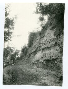
Photograph - Hofen's cutting, Bete Bolong, Orbost district, early 20th century
This photograph is of a cutting on a road at Bete Bolong known as Hofen's Cutting. This photograph was taken c. 1906 when transport was by horse, wagon and prior to cars and railways.This is a pictorial record of early Bete Bolong showing a road through a cutting which was known as Hofen's cutting. Two black / white photographs showing a dirt road heading down a cutting with a post and rail wooden fence on the left side in the background. In 958.1 there is a cut - away hillside beside the dirt road.on back - "Newmerella" (note: this location is at Bete Bolong and not on Newmerella Hill) 958.1 - on back - "Hofen's Bluff 1906"bete bolong, orbost, tracks/roads -
 Orbost & District Historical Society
Photograph - black and white photograph
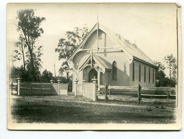
This fine wooden building is located in Browning Street, Orbost and is now (2022) used as the St Andrews Uniting Church Hall. It has a supper room and toilets attached and is a hall that has been used for many community purposes including a Flower Show, exhibitions, concerts, Sunday School, and Harvest Festival etc. In1977, the Orbost Presbyterian Church became the Orbost Uniting Church and the old church became a hall when a new church was built nearby. an excellent photograph of this building which shows the original fence A b/w photograph of a building which is a church with the entrance to the front of the picture. A fence made partly of post and rail, and of white picket in the front of the photo. Some trees in the background. No people can be seen. On back of this photo: 'The first Presbyterian services were held by Rev. Charles Atwood in 1885. He held services in the Mechanics Institute for 5 years. The Presbyterian Church was opened on 9th January 1898. Timber was cut at Richardson's Tabbara mill. Mr R P Cameron built the Church.'presbyterian church, orbost -
 Bendigo Historical Society Inc.
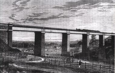
Photograph - TARADALE RAILWAY VIADUCT - ENGRAVING
Photocopy of photo: engraving shows Taradale Railway Viaduct completed. Steam train on viaduct. Stone piers supporting railway line on bridge. Underneath viaduct, post and rail fence, cottages in background.railways, bendigo to melbourne, taradale viaduct -
 Lakes Entrance Historical Society
Postcard - Princes Highway Kalimna, 1920c
Black & white small format postcard of the Princes Highway at Kalimna. It shows the gravel road between the steep road cutting and post & rail fence. Bass Strait in distance. Lakes Entrance Victoriaroads and streets, fences, waterways -
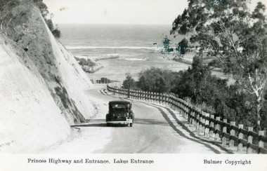 Lakes Entrance Historical Society
Postcard - The Entrance, Bulmer H D, 1930c
Black and copy 9 x 13.5, has inscription 'Princes Highway and Entrance, Lakes Entrance', ink spill on photo top right hand areaTinted small format postcard of the Princes Highway winding around Jemmys Point, between the steep road cutting and post and rail fence, entrance to Gippsland Lakes in the distance. Lakes Entrance Victoria waterways, roads and streets, vehicles -
 Lakes Entrance Historical Society
Postcard, Bulmer H D, 1920c
Black and white copy same sizeTinted postcard of a bend in the Princes Highway, Jemmys Point. It shows the road between the steep cutting and post and rail fence. Glimpse of footbridge to Bullock Island, entrance and hummocks. Lakes Entrance VictoriaPrinces Highway, Lakes Entrance topography, waterways, roads and streets -
 Surrey Hills Historical Society Collection
Photograph, Looking towards Box Hill from the site of the Surrey Hills Golf Club, 1902, 1902
Reproduced by permission of Mr John Arnold from his book: "The Riversdale Golf Club - a history, 1892-1977." Copyright to book: Riversdale Golf Club. Surrey Hills Golf Club operated from 1892-1908 then moved and became Riversdale Golf Club. The game was played across paddocks from Trafalgar Street, Mont Albert to Whitehorse Road and down Victoria Crescent to where Box Hill TAFE is now located in Elgar Road. There were problems with cows eating the tee flags! The clubhouse still exists as 30 Trafalgar Street.Black and white photo with a large grassy paddock in the foreground. From the bottom left and right post-and-rail fences converge on a group of large industrial buildings in the centre middle distance. In the background are paddocks and buildings."Top: Looking towards Box Hill from the links in 1902. The old Box Hill Gas Works is in the centre of the picture."sports grounds, surrey hills golf club, riversdale golf club, box hill gas works, gasworks, public utilities, gas -
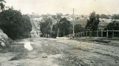 Ringwood and District Historical Society
Photograph, Looking south down Warrandyte Road, Ringwood around 1920
Black and white photograph taken just below where Mullum Mullum Road meets Warrandyte Road.The Mullum Mullum Bridge can be seen in the dip, with numerous houses on the ridge on Whitehorse Road (Maroondah Highway). The fencing was post and rail, with Warrandyte Road unmade, sealed with crushed rocks. -
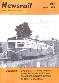 Ringwood and District Historical Society
Booklet, Newsrail June 1978 95c Victoria's Modern Railway Magazine
Glossy black and white booklet of 24 pages, with black and white and orange coloured front coverFeaturing: LIVE STEAM AT ARHS MUSEUM, POST-CENTENARY PORTLAND, TRANSPORT MINISTER SPEAKS, BY RAIL TO LILLYDALE, TRAFFIC, WORKS, ITEMS OF INTEREST, LETTERS TO THE EDITOR, CHANGING TIMES AT ARMADALE -
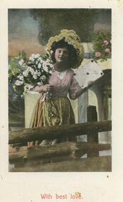 Bendigo Historical Society Inc.
Postcard - POSTCARD. PHOTO OF YOUNG GIRL HOLDING A BUNCH OF FLOWERS IN HER RIGHT HAND
Postcard. Photo of young girl holding a bunch of flowers in her right arm, the bottom of a flat plate in her left hand, standing at a post and rail fence. With best love. Rear. Some names deleted. -
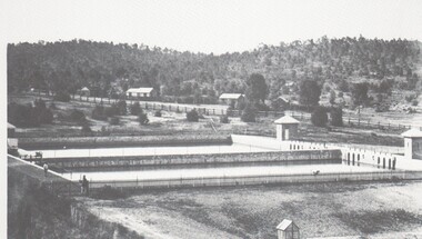 Bendigo Historical Society Inc.
Photograph - HARRY BIGGS COLLECTION: SETTLING PONDS, CRUSOE
Photograph (proof56) of the settling ponds at Crusoe Gully Reservoir. There are two of the ponds visible and two men standing on the left hand side of the photo. In the background there is a post and rail fence bordering a roadway and a timbered hill behind these.place, water, settlinbg ponds, settling ponds , crusoe reservoir -
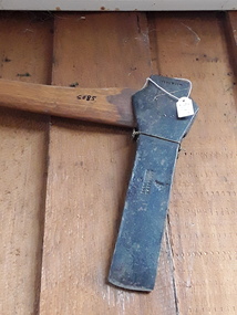 Mont De Lancey
Tool - Mortising Axe, Unknown
Used in the late 19th century.A forged steel narrow headed mortising axe with a long wooden handle. It was used in the construction of post and rail fences where it could be used to chip out small pieces in the wood. It was used in the late 19th century.Indecipherableaxes, cutting tools, hand axes, froes, woodworking tools, cleaving tools -
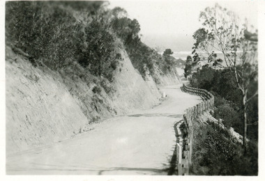
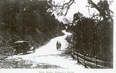 Lakes Entrance Historical Society
Photograph - Princes Highway Lakes Entrance, 1920c
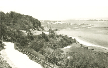
Black and white photograph of the newly formed Princes Highway. It shows the steep cutting into the Jemmys Point hill, the winding road, the post and rail fence, two people and car of the era on road. Lakes Entrance VictoriaNew Road Jemmy's Pointtopography, waterways, roads and streets, fences -
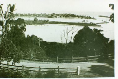 Lakes Entrance Historical Society
Photograph - The Entrance, 1930 c
Black and white photograph of the Princes Highway at Jemmys Point, showing post and rail fence beside road, Bullock Island, the houses of Carpenter town on the southern shore of Cunninghame Arm and Entrance. Lakes Entrance VictoriaLakes Entrance- Gippsland Lakes'coast, fences, roads and streets -
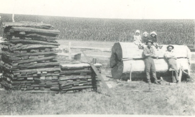 Lakes Entrance Historical Society
Photograph, Alf and Herb Howlett, 1920 c
splitting railings for post and rail fence from huge log. Three small children seated on log unknown location in VictoriaBlack and white photograph showing Alf and Herb Howlett genealogy, farm, families -
 Phillip Island and District Historical Society Inc.
Photograph, Anderson Family, 1869
Brickworks situated on large farming area. Built soon after his arrival on Phillip Island in 1868.Brickworks in rural setting. Slender tree trunks in foreground alongside river. Post and wire fence with slip-rail gate. Large brick building and pavilion-type sheds with canvas awnings. Wood piled up outside.local history, photography, photographs, slides, film, buildings, historic, brick works of robert anderson snr, at phillip island, black & white photograph, mrs emma anderson jacobs -
 Bendigo Historical Society Inc.
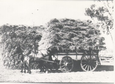
Photograph - HARRY BIGGS COLLECTION: HAY CARTING
Photograph of two horses harnessed to a wagon which has a high load of hay, they are standing next to a haystack. There is a small section of post and rail fence visible, lower right background. On the back is written Dingee, negative 201topic, farming, hay carting, horses , hay carting -
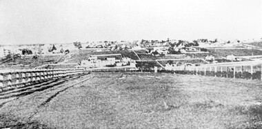
 Sunbury Family History and Heritage Society Inc.
Photograph
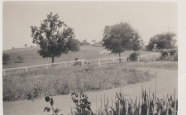
This is a view of one of the settled parts of Sunbury when it was a small country service town and before its rapid suburban expansion.A black and white photo with a cream border of a landscape in a country town. A driveway is in the foreground wi A small settlement on a distant rise is visible. a post and rail fence in the middle distance and two tries growing beyond the fence line. -
 Lakes Entrance Historical Society
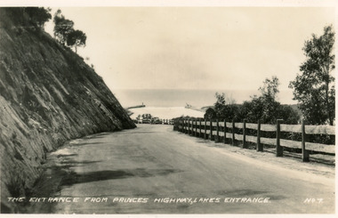
Postcard - Princes Highway Lakes Entrance, Valentine Series, 1940c
Black and white small format postcard of the Princes Highway at Kalimna Hill The road winds between the steep road cutting and a post & rail guard fence. In the distance is the artificial entrance to the Gippsland Lakes. Lakes Entrance VictoriaThe entrance from Princes Highway, Lakes Entranceroads and streets, fences -
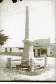 Lakes Entrance Historical Society
Photograph - Cenotaph, Bess Larkins, 1930c
This is the before image used in the 150 year Lakes Entrance 1858 - 2008 display held in 2008.Black and white photograph of Lakes Entrance Cenotaph War Memorial on Esplanade with WW1 names engraved, surrounded by fence of stone corner posts with iron guard rail. Cafe on opposite side of Esplanade. Lakes Entrance Victoriaworld war 1914-1918, memorials -
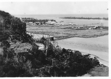 Lakes Entrance Historical Society
Postcard - Lakes Entrance from Jemmys Point, 1930c
Also 2x identical 6cm x 8.5 cmBlack and white small format postcard, showing the North Arm bridge; town; post and rail fence beside highway; Cunninghame Arm and sand hummocks; fishing boat on sand below hill. Lakes Entrance Victoriabridges, fences, boats and boating -
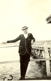 Federation University Historical Collection
Photograph - Black and White, H. Perkins, Frank Wright on Cleveland Pier, Queensland, 1923
Frank Wright was a renown resident of Smeaton, where he was born on 2 August 1901. He lived at Laura Villa, and attended Smeaton State School. His father William was a gold miner and his mother's name was Sarah. Their family won many singing and instrumental awards. Frank was tutored by Percy Code and was awarded a gold medal for the highest marks in the ALCM examinations in the British Colonies at the age of seventeen years. He became the Australian Open Cornet Champion by the age of eighteen. A year later, Frank conducted the City of Ballarat Band, and later the Ballarat Soldiers’ Memorial Band. He formed the Frank Wright Frisco Band and Frank Wright and his Coliseum Orchestra. These bands won many South Street awards, and Frank as conductor won many awards in the Australian Band Championship contest. In 1933 Frank Wright sailed to England to conduct the famous St Hilda’s Band and was later appointed Musical Director of the London County Council, where he organized many amazing concerts in parks, in and around the London district. He was made Professor of Brass and Military Band Scoring and conducted at the Guildhall of Music and Drama. Frank was often invited to adjudicate Brass Band Championships around Europe, in Australia, including South Street and in New Zealand. The Frank Wright Medal at the Royal South Street competition is awarded to an individual recognized as making an outstanding contribution to brass music in Australia.Black and white photograph of a man wearing a hat and a dark suit with white piping around the edges of the jacket. He is leaning against the post and rail fence of a pier. The man is Frank Wright and the place is Cleveland on the bay near Brisbane.Written in pen on the back - Frank Wright (21) on Cleveland pier near Brisbane, Q, Easter 1923, Taken by H Perkinsfrank wright, cleveland pier, h perkins -
 Glenelg Shire Council Cultural Collection
Photograph - Photograph - Main Breakwater construction, Portland, 31/05/1957
Port of Portland Authority ArchivesBack: 31.5.57port of portland archives, main breakwater construction, harbour development -
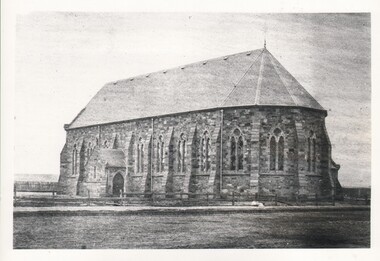 Bendigo Historical Society Inc.
Photograph - WES HARRY COLLECTION: ST. KILLIANS CHURCH, 1860's
Photograph of a large stone church, There is a paling fence visible each side at the rear of the church and a post and rail fence in front of the building. This was the first St. Kilian's church to be built (note that on the rear of the photo it says ' All Saints Church ' )buildings, church, st. killians, st. kilian's church -
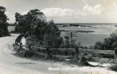
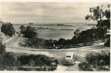 Lakes Entrance Historical Society
Postcard - Princes Highway Kalimna, Valentine Series, 1930c
Black and white postcard of a bend in the Princes Highway as it winds around Jemmys Point, car parked beside highway, two people leaning on post and rail fence, Bullock Island and Lakes Entrance in the distance. Lakes Entrance VictoriaPrinces Highway Lakes Entrancefences, transport, roads and streets