Showing 373 items matching "princes highway"
-
 Lakes Entrance Historical Society
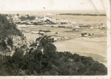
Postcard - Township, 1930c
... Lakes Entrance from Princes Highway (on back)... Princes Highway (on back) Black and white small format postcard ...Black and white small format postcard showing the township situated on the land between the Cunninghame Arm and North Arm. Lakes Entrance VictoriaLakes Entrance from Princes Highway (on back)bridges, township, topography, waterways -
 Lakes Entrance Historical Society
Photograph - Kite Festival, 1/11/1995 12:00:00 AM
... Princes Highway viewing Point Kalimna showing Bullock...Colour photograph taken from Princes Highway viewing Point...Princes Highway viewing Point Kalimna showing Bullock ...Princes Highway viewing Point Kalimna showing Bullock Island during the International Kite Festival. The vast expanse of dumped sand perfect for Kite Flying but not the environment covers a large area of the island Lakes Entrance Victoria. Also a colour photograph taken of banners and kites at the Foorbridge venue of the International Kite Festival number 04048.1Colour photograph taken from Princes Highway viewing Point Kalimna showing Bullock Island during the International Kite Festival. The vast expanse of dumped sand perfect for Kite Flying but not the environment covers a large area of the island Lakes Entrance Victoria. Also 2 colour photographs taken of banners and kites at the Footbridge venue of the International Kite Festival number 04048.1 and 04048.2 sports, kites, events -
 Lakes Entrance Historical Society
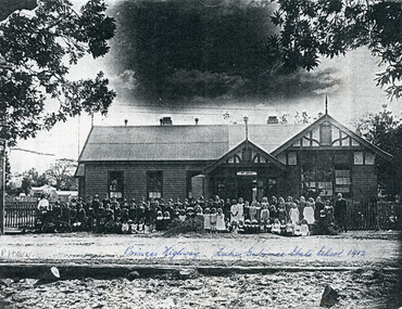
Photograph - Lakes Entrance State School, 1912
... Princes Highway, Lakes Entrance State School 1912...Schools Buildings Princes Highway, Lakes Entrance State ...Paper photocopy of black and white print of Lakes Entrance State School no 2672 with teachers and children in front of building facing the lake, highway in front. Lakes Entrance VictoriaPrinces Highway, Lakes Entrance State School 1912schools, buildings -
 Glen Eira Historical Society
Plan - Nettalie
... Princes Highway... Orrong Road Dandenong Road Princes Highway Kooyong Road Alma Road ...An A4 photocopy of the 'Plan of the Caulfield Road District' dated 1867. This plan shows the location of the properties owned by A Shaw and Blundell on Balaclava and Orrong Roads where Nettalie is situated. The plan includes all the landowners listed where their property was, the street names and other landmarks of 1867 including railways, hotels and reserves.caulfield, caulfield north, elsternwick, st kilda east, parish of prahran, parish of moorabbin, caulfield road district, melbourne and brighton railway, rosstown railway, elsternwick railway station, caulfield railway station, rosstown railway station, murrumbeena railway station, baptist church, paddy’s swamp reserve, cemetery reserve, leman swamp reserve, caulfield racecourse reserve, brighton cemetery, the vine caulfield hotel, the tam o’shanter hotel, melbourne hunt hotel, royal hotel, hotham street, horne street, nepean highway, north road, orrong road, dandenong road, princes highway, kooyong road, alma road, inkerman road, balaclava road, glen eira road, glen huntly road, hawthorn road, cemetery road, bambra road, redan road, kambrook road, neerim road, booran road, racecourse road, grange road, koornang road, murrumbeena road, crosbie road, kangaroo road, poath road, ford w, lempriere, cople j, riddell j c, manifold j, testar t, billing r h, semple, blundell, shaw a, butchart g, stephen j w, stephen g sir, hart j, duncan g, blackie r, stephen f, mccombie t, woollaston h, higgins j, lloyd j c, daish j, mcleod j, hughes d, wilson a, jamieson g, webb g h, renwick s, pennington h, dunn j, kirkpatrick w, ricketson w, toad a, sayce j, watts t, widgery, store, guess j, anketell j, clack j, sissen w, clayton g, dickson d, bevan j, hart t, anderson j, hart mrs, webb h, masters s, waghorn j, hemming c, hiam c, farquhar w, newing t, payne t, cooper r, snipe s, chambers j, forster w, summers r, harriman b, warrick, o’connell, long j, peck r, cochrane c, murray ross w, evans c, kennedy j, maclean n, forster, lyall w, dean j, newton h, looker w, baker c, johnston, crosbie j, kerr, jones, parr, nelson c, montgomery l, parsons w, james j c, sibon c, smith sydney w, plans, maps, land subdivisions, land use, settlements, roads and streets, hotels, churches, police stations, post offices, land surveys, railway stations, railways, schoolhouses, commerce, clergy residences, official buildings, local government, road districts -
Glen Eira Historical Society
Book - Local Government Act First Report of the Assistant Commissioner of Roads and Bridges
... Princes Highway... Road Princes Highway Brown Edwin Osher Joseph Cosgrove John ...This file contains 1 item: 1/The Local Government Act, First Report of the Assistant Commissioner of Roads and Bridges, printed by order of the Victorian Legislative Assembly on 08/03/1865. The document is the first annual report of John Steavenson, Assistant Commissioner of Roads and Bridges under s330 of the Local Government Act no. 176 (1863), and relates to transactions which took place from 02/09/1863 to 31/12/1864. The report outlines operations carried out by the Department of Roads and Bridges in this period. In the Glen Eira area this includes: separating electoral subdivisions of single districts (Moorabbin), adding detached portions of territory to road districts and shires (Caulfield), appointing of and altering in polling places, appointing of polling places for ridings of shires and subdivisions of road districts (Moorabbin), preparing and transmitting of forms of books also of pro forma accounts for guidance of local bodies in keeping their accounts, appointment of main roads, construction of a main road, ‘Dandenong’, in the Caulfield and Gardiner districts, proclaiming of Common Toll Roads, names of and security given by Managers of Common Toll Roads. The report also gives some information about the Shire of Caulfield, which contained 24 road districts and 340 rate payers in 8¼ square miles, and the Shire of Moorabbin, which contained 62 road districts and 713 rate payers in 30 square miles.local government act, assistant commissioner of roads and bridges, legislative council, caulfield historical soceity, steavenson john, sullivan j. f. the honourable, caulfield, moorabbin, road districts, point nepean road, nepean highway, dandenong road, princes highway, brown edwin, osher joseph, cosgrove john, ferres john, roads and bridges offices, caulfield roads district, moorabbin roads district, road construction and maintenance, roads and streets, acts of parliament -
Glen Eira Historical Society
Document - MOORABBIN TRANSIT
... Princes Highway.... Princes Highway Murrumbeena Road Sydney Street Hobart Road Neerim ...This file contains one item: 1/A Moorabbin Transit printout of the bus timetable information for Route 822, effective 05/08/2002. Includes a description and a map of the route.princes highway, murrumbeena road, sydney street, hobart road, neerim road, crosbie road, north road, malborough street, stockdale avenue, gardeners road, quinns road, east boundary road, murrumbeena, bentleigh east, buses -
Glen Eira Historical Society
Document - Moorabbin Transit
... Princes Highway.... Princes Highway Murrumbeena Road Sydney Street Hobart Road Neerim ...This file contains one item: 1/A Moorabbin Transit printout of the bus timetable information for Route 822, effective 05/08/2002. Includes a description and a map of the route.princes highway, murrumbeena road, sydney street, hobart road, neerim road, crosbie road, north road, malborough street, stockdale avenue, gardeners road, quinns road, east boundary road, murrumbeena, bentleigh east, buses, bus stops, bus services, transport -
 Port Fairy Historical Society Museum and Archives
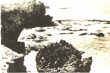
Postcard, "The Crags", c. 1930
... princes highway... the crags rocks sea ocean princes highway The crags Port Fairy ...The crags- Circa 1930Photograph Rocky area with ocean waves washing over The crags Port Fairy the crags, rocks, sea, ocean, princes highway -
 Port Fairy Historical Society Museum and Archives
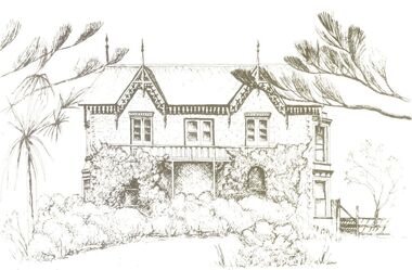
Drawing - Postcard, Talara Port Fairy
... princes highway... Street Port Fairy great-ocean-road talara princes highway house ...Photo of a postcard of Talara a 2 story house with bushes and ivy covering most of the lower storytalara, princes highway, house, cottage, building, rutledge, remington, powell -
 Port Fairy Historical Society Museum and Archives
Photograph
... princes highway... House building cottage princes highway Black and white ...Talara - photo 1986Black and white photograph of Talara a two story house talara, house, building, cottage, princes highway -
Port Fairy Historical Society Museum and Archives
Photograph
... princes highway... princes highway building house cottage Black and white photograph ...Talara one of three large houses built on the hill on the outskirts of Port FairyBlack and white photograph talara, princes highway, building, house, cottage -
 Port Fairy Historical Society Museum and Archives
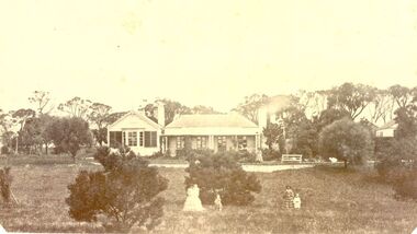
Photograph
... princes highway... by Horace Flowers Esq leura h flowers esq House station farm princes ...Leura Station homestead owned by Horace Flowers EsqBlack and white photograph of Leura station homestead with several women and children standing outsideleura, h flowers esq, house, station, farm, princes highway, building, horace -
 Port Fairy Historical Society Museum and Archives
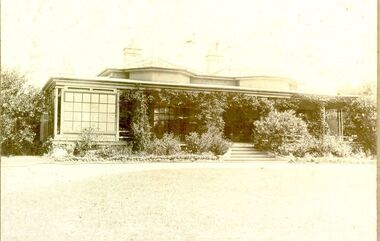
Photograph, Boodcarra
... princes highway... building princes highway J.ritchie Boodcarra Photograph ...Photograph of Boodcarrra Station with plant growth around front verandahBoodcarraboodcarra, station, house, building, princes highway, j.ritchie -
 Port Fairy Historical Society Museum and Archives
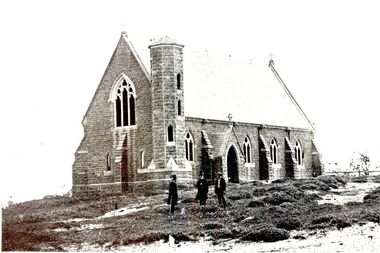
Photograph
... Princes highway...-school building catholic st patrick's Princes highway Black ...St. Patrick’s Roman Catholic Church Built 1859-1867 Foundation stone laid in July 1857, money being raised be subscription and a government grant. Charles Hansom was the Architect, Nathaniel Billing Engineer. Chancel and sacristy were added in 1867, stained glass windows added in 1868. This looks to be a very early photo of the church.Black and white photograph of Large bluestone church with tower with crosses on gable ends and 3 panel arched windowschurch, sunday-school, building, catholic, st patrick's, princes highway -
 Phillip Island Conservation Society Inc.
Work on paper - Photocopy of newspaper cutting, "PHILLIP ISLAND/A place to fall in love"
... Princes Highway... Township of Rhyll Phillip Island Princes Highway Dandenong Pakenham ...This article was written by an English visitor named Elsa Christian who was touring Australia and New Zealand with her husband Frank in their own small van. The article was published in the Australian Women’s Weekly, magazine, March 1966. Elsa writes she wanted to visit four Australian locations before she died: Ayers Rock (actually Uluru), the Snowy River project, dolphins at Coolangatta and the Penguin Parade at Phillip Island. These destinations were all very popular in the 1960s for both Australian residents and overseas visitors. Because the roads were becoming better too many locations, self guided tours in small vans for cars towing bond would caravans were becoming more popular means of seeing AustraliaThe article is significant in many ways. 1. Indicates the places English visitors commonly wish to see in Australia. 2. Describes the growing trend to self- drive van/camping holidays. 3. Gives the route taken from Melbourne to Phillip Island during the 1960s. 4. Describes the appearance of the roadsides and locations visited. 5. It is written in a descriptive and lyrical style designed to appeal to Women’s Weekly magazine readers, who were probably wondering how they could visit Phillip Island with their husbands or families themselves, and what there was to see there. 6. Gives the visitors’ view of how the Penguin Parade operated at the time. 7. Includes a description of potter and artist Eric Juckert’s renowned garden at Grossard Point, Ventnor. 8. Indicates how introduced plants such as Hawthorn pushes and Kate weed were common in the area. 9. Describes Phillip Island as “a place to fall in love” because of its natural beauty, fauna and coastal seascapes. 10. As a visitor Elsa describes the housing estates as a blot on the landscape, but also sees the value as a way of their owners escaping from the hustle and bustle of Melbourne. 11. Gives the visitors’ interpretation of the behaviour of wildlife the RC in the wild, as well as Elsa’s knowledge about some of the species she encounters.Photocopy of full page article with 5 columns of text, a map and 2 photographs. Black ink on white paper. Photographs blackened in photocopying processphillip island, cape woolamai, penguin parade, seal rocks, nobbies, township of rhyll phillip island, princes highway, dandenong, pakenham, kooweerup, carinya creek, officer, san remo, gippsland highway, holiday homes, fort dumaresq, kitty miller's beach, wreck of the speke, hereford cattle, fleetwood manor, koalas, ventnor, eric juckert, little penguin behaviour -
 Orbost & District Historical Society
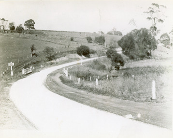
black and white photograph, 1913
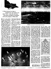
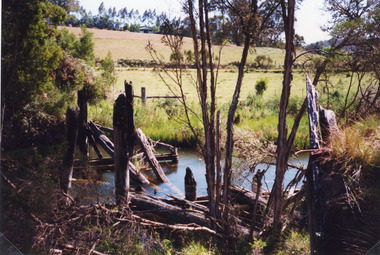
... on back - "Country Roads Board Princes Highway low level..., East Gippsland. on back - "Country Roads Board Princes Highway ...This photograph is of the low level bridge across the Bemm River about 50 km east of Orbost in East Gippsland.This is a pictorial record of the 1913 low level bridge across the Bemm River, East Gippsland.A large black / white photograph of a horse - drawn wagon on the low level Bemm River bridge. In the foreground on the bridge is a dog.on back - "Country Roads Board Princes Highway low level bridge" -
 Lakes Entrance Historical Society
Photograph - Esso Service Station, Lakes Post Newspaper, 1991
... Station Princes Highway Lakes Entrance Victoria... Fileder of Esso Service Station Princes Highway Lakes Entrance ...Black and white photograph of David Fileder of Esso Service Station Princes Highway Lakes Entrance Victoriabusinesses, people -
 Lakes Entrance Historical Society
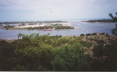
Postcard - Bullock Island Lakes Entrance, H D Bulmer, 1950 c
... no development. North Arm bridge and Princes Highway in foreground, New... and Princes Highway in foreground, New Works area across Cunninghame... no development. North Arm bridge and Princes Highway in foreground, New ...Bullock Island and first traffic bridge. Bullock Island has no development. North Arm bridge and Princes Highway in foreground, New Works area across Cunninghame Arm in distance Lakes Entrance Victoria. Also a cut down colour photograph of second humpy bridge to Bullock Island donated by M Fish number 04208.1 size 3 x 13 cm|Also two black and white photographs numbers 04208.2 and 04208.3 in SparesColour tinted postcard of Bullock Island and first traffic bridge. Bullock Island has no development. North Arm bridge and Princes Highway in foreground, New Works area across Cunninghame Arm in distance Lakes Entrance Victoria. Also a cut down colour photograph of second humpy bridge to Bullock Island donated by M Fish number 04208.1 size 3 x 13 cm|Also two black and white photographs numbers 04208.2 and 04208.3 in Spares Bullock Island and Bridge Lakes Entrance waterways, gippsland lakes, islands, vegetation -
 Lakes Entrance Historical Society
Photograph, 1998
... on the former Princes Highway at Toorloo Arm Road, Lake Tyers, Victoria... of a timber bridge on the former Princes Highway at Toorloo Arm Road ...Colour photograph of the remains of a timber bridge on the former Princes Highway at Toorloo Arm Road, Lake Tyers, Victoriabridges, waterways -
 Lakes Entrance Historical Society
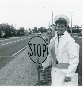
Photograph - St Brendans Lakes Entrance, Lakes Post Newspaper, 1992
... Cheers at St Brendans school crossing on the Princes Highway... crossing on the Princes Highway, Lakes Entrance Victoria Photograph ...Other number 02754.2Black and white photograph of Lolly pop lady Christine Cheers at St Brendans school crossing on the Princes Highway, Lakes Entrance Victoriaschools, safety -
 Lakes Entrance Historical Society
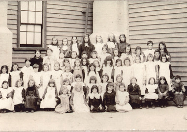
Photograph - Lakes Entrance State School, 1904
... Entrance State School no 2672, Princes Highway, girls only. Lakes... outside Lake Entrance State School no 2672, Princes Highway, girls ...Black and white photograph of children outside Lake Entrance State School no 2672, Princes Highway, girls only. Lakes Entrance Victoriaschools, students -
 Lakes Entrance Historical Society
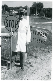
Photograph - St Brendans Lakes Entrance, Lakes Post Newspaper, 1992
... at St Brendans school crossing on the Princes Highway, Lakes... on the Princes Highway, Lakes Entrance Victoria Photograph St Brendans ...Other number 02754.1Black and white photograph of Lolly pop man Des Thomas at St Brendans school crossing on the Princes Highway, Lakes Entrance Victoriaschools, safety -
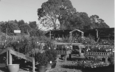 Lakes Entrance Historical Society
Photograph - Garden Supplies, Lakes Post Newspaper, 1/07/2000 12:00:00 AM
... area previously Cox's Garden Supply Princes Highway Kalimna... Supply Princes Highway Kalimna West Victoria Photograph Garden ...Managers of Whelans Garden Supply Joe and Judy Rourke and Lisa and Jim BlakeColour photograph of Whelan's Garden Supply plant display area previously Cox's Garden Supply Princes Highway Kalimna West Victoriabusinesses, plant nursery -
 Lakes Entrance Historical Society
Photograph - Riviera Trading Post, Lakes Post Newspaper, 1/11/1992 12:00:00 AM
... owners of Riviera Trading Post 191 Princes Highway Lakes Entrance... and Freda Horton new owners of Riviera Trading Post 191 Princes ...Black and white photograph of David and Freda Horton new owners of Riviera Trading Post 191 Princes Highway Lakes Entrance Victoriabusinesses, people -
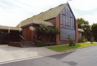 Lakes Entrance Historical Society
Photograph - St. Brendan's Lakes Entrance, 2008
... is situated in the grounds of St Brendans Catholic School, Princes... of St Brendans Catholic School, Princes Highway, Lakes Entrance ...Date made August 2008Colour photograph of the St Brendans Catholic Church which is situated in the grounds of St Brendans Catholic School, Princes Highway, Lakes Entrance, Victoria.churches, buildings -
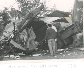 Lakes Entrance Historical Society
Photograph - Truck Accident Bennett's Brook, Swan Reach Victoria, 1/09/1992 12:00:00 AM
... meat truck after accident on Princes Highway at Bennett's Brook... showing wrecked refrigerated meat truck after accident on Princes ...Truck was carting beef to Orbost driver escaped with minor injuriesBlack and white photograph showing wrecked refrigerated meat truck after accident on Princes Highway at Bennett's Brook near Swan Reach Victoria transport, disasters, vehicles -
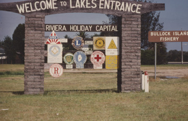 Lakes Entrance Historical Society
Photograph - Welcome to Lakes Entrance sign, Lakes Post Newspaper, 1989 c
... at the western entry to town situated adjacent to Princes Highway... situated adjacent to Princes Highway and Marine Parade Lakes ...Colour photograph of the Welcome to Lakes Entrance sign at the western entry to town situated adjacent to Princes Highway and Marine Parade Lakes Entrance Victoria tourism, advertising, signage -
 Orbost & District Historical Society
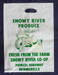
Container - Plastic bag/container, plastic bag SNOWY RIVER CO-OP
... RIVER CO-OP PRINCES HIGHWAY MEWMERELLA Side 2: SNOWY RIVER CO.... FRESH FROM THE FARM SNOWY RIVER CO-OP PRINCES HIGHWAY ...A plastic produce bag from c.1990s used for promotion of the SNOWY RIVER PRODUCE Co. which was famous as a sweet corn producer. The sweet corn was grown locally under contract by farmers in the Orbost district and marketed through the Co. This company no-longer exists (2022).a rare item to survive as evidence of the Snowy River Produce CoA white plastic bag, printed on both sides with green print. One side has a drawing of a bucking horse and rider, and the other side a piece of yellow coloured corn. The bag has a hand hold opening. Size of bag: H-504mm W-362mmSide 1: SNOWY RIVER PRODUCE. FRESH FROM THE FARM SNOWY RIVER CO-OP PRINCES HIGHWAY MEWMERELLA Side 2: SNOWY RIVER CO-OP FAMOUS FOR SWEET CORN PRINCES HIGHWAY NEWMERELLA phone (051) 541878orbost, sweet corn, farming produce, snowy river produce co. -
 Lakes Entrance Historical Society
Photograph, 1947
... Black and white photograph of the Princes Highway bridge... Black and white photograph of the Princes Highway bridge over ...1/02/1947 12:00:00 AMBlack and white photograph of the Princes Highway bridge over Bunga Creek showing the sharp bend in the road as it crosses the creek east of Lakes Entrance Victoriabridges, transport, roads and streets -
 Lakes Entrance Historical Society
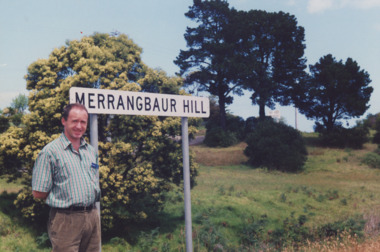
Photograph - Merrangbour Hill Lakes Entrance Victoria, Lakes Entrance Organic Gardening Society, 1995
... entrance from Princes Highway Tim Gibson standing beside sign... showing Merrangbour Hill sign at Eastern entrance from Princes ...Colour photograph showing Merrangbour Hill sign at Eastern entrance from Princes Highway Tim Gibson standing beside sign to Lakes Entrance Victoriahistoric sites, lakes entrance, signage