Showing 90 items
matching public common
-
 Vision Australia
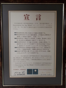
Ceremonial object - Image, Proclamation, 1985
Copies of the Proclamation of understanding between the Association for the Blind and the Seimei Association for the Welfare of Aged Blind, Inc., in both English and Japanese. These agreements were a symbol of the exchanges of each organisation, and the growing trend of agencies to link more to compatriots overseas as telecommunications improved.2 digital images of memorandum of understanding between Association for the Blind, Melbourne, Australia & The Seimei Association for the Welfare of the Aged Blind IncProclamation Whereas the Association for the Blind, Melbourne, Australia & The Seimei Association for the Welfare of the Aged Blind Inc, Oume City, Japan, are organisations which: - promote the welfare of people who are blind or visually impaired especially the elderly; - provide welfare programs, accomodation, medical and nursing assistance, and support to people who are blind or visually impaired; - strive to overcome problems associated with blindness, whether physical, psychological, educational, social or economic; - provide appropriate rehabilitation services to enable people to use their capabilities and to develop their skills so that they can participate as fully as possible in the community; - promote the interests of people who are blind or visually impaired and provide information to the general community; and - provide at all times services to a high professional standard with a spirit of care and understanding. Therefore let is be known publicly that the Association for the Blind and The Seimei Association for the Welfare of Aged Blind, Inc. formally establish a sister organisation relationship for the attainment of these common aspirations for people who are blind or visually impaired, especially the elderly. In Witness Thereof the Association for the Blind & The Seimei Association for the Welfare of the Aged Blind, Inc. cause their representatives to set their hands hereto on the 8th June, 1985. (Diana Jones) For the Association for the Blind, Melbourne Australia (signature) For The Seimei Association for the Welfare of the Aged Blind, Inc., Oume City, Tokyo, Japanseimei association for the welfare of aged blind inc., association for the blind -
 Tarnagulla History Archive
Telegram, 20th March, 1862
A large lot of papers, including this and other telegrams, were apparently found in the ceiling cavity of the Sandy Creek/Tarnagulla Post and Telegraph Office in the later 20th Century, during building works. Donald Clark Collection. Telegram sent from Tarnagulla, from Patrick Fahey, Seniro Constable to Sergt Acton, Inglewood. Message reads 'Re criminal offence of this date. Man named Jas. Murphy arrested here answers this description except in hight (incorrect spelling). Six small common brooches found in his possession & _____ ______ _______ packet inside ('left breas' crossed out) right breast, and one outside left breast. ________ required. Reply.' -
 Tarnagulla History Archive
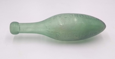
Torpedo Bottle - Whittaker Bros. Tarnagulla / Maryborough
David Gordon Collection. Torpedo bottles, also known as Hamilton bottles, were used for aerated or carbonated water. They were oval shaped with a neck at one end, and were deliberately designed so that they could not be stored upright. Torpedo bottles were in common use from the 1840s to the 1870s, when they were superseded by the Codd Neck bottle. -
 Parks Victoria - Wilsons Promontory Lightstation
Desk
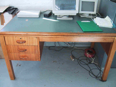
This fairly substantial wooden desk with vinyl top was issued to Wilson’s Promontory Lightstation by the Department of Public Works in the 1960’s. Primarily the desk was used for correspondence purposes, and now has the Bureau of Meteorology computer stationed on it. Although the design and make of this desk is common to many lightstations across Victoria, it is a good example of the kind of furniture that was provided to Victorian lightstations in the 1960’s. The solidly constructed desk was used in the lightstation office. It is made of honeycoloured hardwood and has a green vinyl top and three drawers on the left side. The style suggests that it may date to the 1960s. Gabo Island Lightstation has two identical desks, and all were probably standard issue from the Commonwealth Lighthouse Service or Public Works Office. Another twentieth century vinyl topped desk at Gabo is manufactured with a steel frame. Cape Nelson, Cape Schanck, Point Hicks and Gabo Island retain nineteenth century cedar desks. The desk at Wilsons Promontory has second level significance as a good example of the style of office furnishing provided to lightstations in the 1960s.Wooden desk with square legs and green vinyl top. It has three drawers with wooden handles on the left . The top drawer has a keyhole. -
 Bacchus Marsh & District Historical Society
Unknown, Bell Tree Fragment
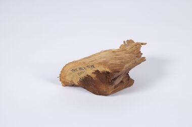
This wood fragment comes from a red gum tree which was planted in the Bacchus Marsh Primary School grounds in the 1860s. It was one of the first trees planted in the school ground in Lerderderg Street. For many years the school bell was hung from this tree. This practiced ceased about 1969 and some years later the tree had to be removed as it had become damaged. This wood fragment was saved from the 'bell tree' when this was done. The wood fragment is an indicator of a once common, but now generally non-existent school practice of the ringing of a bell to communicate school commencement and finishing times during the school day. It has particular significance because Bacchus Marsh Primary School was the first government funded public primary school in Victoria.Red Gum tree wood fragmentschools, bacchus marsh primary school -
 The Celtic Club
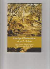
Book, Val Noone et al, Gaelige Ghrianduite A go Z ahOn (Sunburnt Irish), 2021
Gaeilge Ghriandóite: A go Z a hAon/ Sunburnt Gaelic from A to Z, Edition One, records selected findings of four Australians about the neglected history of the Irish language and Gaelic culture in this country. Gaeilge Ghriandóite/ Sunburnt Gaelic means the Irish language as it is spoken and written in Australia, as it comes to grips with a new environment. It is written throughout in Irish and is the first, and only, such book about the topic. Readers will find that over the past two centuries there have been dramatic breaks in continuity but also common threads. Triggered by positive responses from both experts and general readers alike to talks and papers all four had given on the topic, at a meeting in August 2019 the authors decided that the time was ripe to present to the public some fruits of their collaboration. The book's 108 pages present historical and contemporary facts about Irish-language culture in Australia in short entries, arranged in alphabetical order, with over 60 illustrations. This format makes it easy to find information and suits the present stage of research and publication on the topic. Also the alphabetical listing provides a flexible format for future editions. The book includes two short overview pieces and the first detailed bibliography on the topic.Ill, bib, ports, p.107.non-fictionGaeilge Ghriandóite: A go Z a hAon/ Sunburnt Gaelic from A to Z, Edition One, records selected findings of four Australians about the neglected history of the Irish language and Gaelic culture in this country. Gaeilge Ghriandóite/ Sunburnt Gaelic means the Irish language as it is spoken and written in Australia, as it comes to grips with a new environment. It is written throughout in Irish and is the first, and only, such book about the topic. Readers will find that over the past two centuries there have been dramatic breaks in continuity but also common threads. Triggered by positive responses from both experts and general readers alike to talks and papers all four had given on the topic, at a meeting in August 2019 the authors decided that the time was ripe to present to the public some fruits of their collaboration. The book's 108 pages present historical and contemporary facts about Irish-language culture in Australia in short entries, arranged in alphabetical order, with over 60 illustrations. This format makes it easy to find information and suits the present stage of research and publication on the topic. Also the alphabetical listing provides a flexible format for future editions. The book includes two short overview pieces and the first detailed bibliography on the topic.australia - irish language, australia - irish culture -
 Phillip Island Conservation Society Inc.
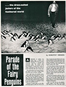
Work on paper - newspaper cutting photocopy, "...the dress-suited jesters of the feathered world/Parade of the Fairy Penguins", unknown
The general public was fascinated by the nightly 'Penguin Parade' on Phillip Island. Many articles have been written about the birds and the Penguin Parade attraction since the 1930s. So many people spent their summer holidays on Phillip Island in one of the many guest houses, then caravan parks and holiday homes and a visit to the Penguin Parade by them and their visitors was very common during their holidays. Articles tended to be a mix of basic penguin behavior information and anthropomorphic descriptions. Accompanying photographs were almost invariably taken by flashlight (now illegal), or of penguins taken from their burrows during daylight hours for photo opportunities. The article provides evidence of the level of knowledge about Phillip Island's Little/Fairy Penguins at this time. (approx 1960?)Photocopy of 2 page magazine article. Black print. Images poor quality due old photocopy.little penguins, fairy penguins, eudyptula minor, phillip island penguin parade, dorothy vernon, penguin rookery, penguin behaviour, phillip island tourist attractions -
 Phillip Island Conservation Society Inc.
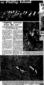
Work on paper - Photocopy of newspaper cutting, (part obscured) "at Phillip Island/Nightly Miracle/from the sea", November 20, 1957
The general public was fascinated by the nightly 'Penguin Parade' on Phillip Island. Many articles have been written about the birds and the Penguin Parade attraction since the 1930s. So many people spent their summer holidays on Phillip Island in one of the many guest houses, then caravan parks and holiday homes and a visit to the Penguin Parade by them and their visitors was very common during their holidays. Articles tended to be a mix of basic penguin behavior information and anthropomorphic descriptions. Accompanying photographs were almost invariably taken by flashlight (now illegal), or of penguins taken from their burrows during daylight hours for photo opportunities. This article, written in the 1950s, describes the management of the Penguin Parade at that time as being run by the Penguin Preservation Committee. This was before the Phillip Island Council took over running the Penguin Parade. The article provides evidence of the level of knowledge about Phillip Island's Little/Fairy Penguins at this time. (1957)single full-page magazine article, black ink on white paper. Photocopied from original, so photos appear as black and white.little penguins, fairy penguins, eudyptula minor, phillip island penguin parade, dorothy vernon, penguin rookery, penguin behaviour, phillip island tourist attractions -
 Phillip Island Conservation Society Inc.
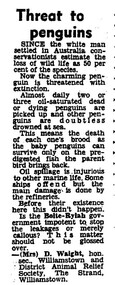
Work on paper - photocopy of letter to editor newspaper cutting, "Threat to/ Penguins"
This letter to the editor of an unknown newspaper probably dates from the late 1960s or early 1970s. At that time the Victorian government’s Liberal Party Premier was Sir Henry Bolte. In a reference to the major industrial valley in Germany, he and his government had a vision to make Western Port and Hastings into “the Ruhr of Victoria”, if not Australia. While this letter does not refer to Western Port, but apparently to Wiliamstown, the situation was similar in both bays. Substantial land was zoned in Hastings by the Bolte Government for industrial purposes, where BP built a refinery for oil imported through the Port of Hastings. The large oil tankers entered Western Port Bay via the western channel, which required dredging to accommodate them. It became a common site to see globules or patches of oil washed up on beaches around Western Port, and oil-affected wildlife. It is impossible to know how many wildlife were affected directly by oil spills and other forms of pollution in the Bay during that era. Sufficient numbers of oiled Little Penguins were found to prompt numerous references to the problem in newspapers, including letters, articles and even major features. The refinery eventually closed, with tanker traffic dramatically reducing in Western Port from the late 20th century.Statement of significance: This letter to the editor is significant in making reference to pollution caused in Port Phillip and Western Port bays by tanker traffic and the presence of oil refineries on industrial land in the bays. It is also indicative of the emergence of many conservation-related community groups of volunteers in Australia during the 1960s and 1970s in response to growing concern around conservation issues. Letters to the editor were a common means for these groups to have their concerns aired in public.Photocopy of newspaper cutting, single column letter to the editor.little penguins, oil spill, western port, port of hastings, henry bolte, "ruhr of victoria", oiled penguins, oiled wildlife, bp refinery, oil tankers, , mrs d waight, williamstown and district animal relief society -
 Wodonga & District Historical Society Inc
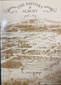
Book - The History of Albury 1824 - 1895, Albury & District Historical Society, Published 1988
The original edition of "The History of Albury 1824 - 1895" was published in 1912. Dr. Andrews took information freely from local newspapers such as the "Albury Banner" and also some early pioneers and contacts. The Albury & District Historical Society produced this facsimile edition included an expanded index and 20 illustrations not in the original version. It was a limited edition of 1000 copies completed as a bicentennial project. This book is number 0538. Dr. Arthur Andrews practised medicine in Albury for 45 years from 1874 to 1919. For 43 years he served as the Government Medical Officer. As was common at that time, his surgery was established in his home. He was actively involved in community life and served on many public offices in the Albury. In his leisure time, Dr. Andrews was engaged in a wide range of historical interests and research of the history of the district. He moved to Sydney in 1919 and died in Cremorne in 1925.A facsimile of The History of Albury 1824 - 1895 which was originally produced in 1912. This edition of 94 pages plus an index not included in the original publication. It also includes a map showing the track taken by early explorers and early photos.non-fictionThe original edition of "The History of Albury 1824 - 1895" was published in 1912. Dr. Andrews took information freely from local newspapers such as the "Albury Banner" and also some early pioneers and contacts. The Albury & District Historical Society produced this facsimile edition included an expanded index and 20 illustrations not in the original version. It was a limited edition of 1000 copies completed as a bicentennial project. This book is number 0538. Dr. Arthur Andrews practised medicine in Albury for 45 years from 1874 to 1919. For 43 years he served as the Government Medical Officer. As was common at that time, his surgery was established in his home. He was actively involved in community life and served on many public offices in the Albury. In his leisure time, Dr. Andrews was engaged in a wide range of historical interests and research of the history of the district. He moved to Sydney in 1919 and died in Cremorne in 1925.albury history, dr. arthur andrews -
City of Kingston
Photograph - Colour, 6 March 1993
Edithvale is a suburb in the City of Kingston. It is located between Aspendale and Chelsea on the Port Phillip Bay and built within remnant areas of the Carrum Carrum swamp. The foreshore precinct comprises a wide sandy beach, with low sand dunes and numerous historic boat sheds. The suburb consists of older style dwellings and former holiday houses, combined with mid-century housing and newer homes. The large blocks are increasingly subdivided and the existing dwellings demolished to accommodate units and townhouses, thus changing the landscape of the area and reducing the tree canopy.The beachside suburb of Edithvale was previously part of the extensive Carrum Carrum Swamp. The area was once a source of fish and eels for the Mayone-Bulluk clan of the Bunurong people. Over time the area was drained and predominantly devoted to dairy farming and holiday houses. The farms were gradually sold and subdivided with a large number of homes built after World War II and in the 1960s. Edithvale is mainly residential with a shopping strip along Nepean Highway but little significant industry was ever established in the area apart from a plaster works and confectionary factory, both now closed.Laminated aerial colour photograph of Edithvale as viewed from Alexandra Avenue in the north to Ella Grove Chelsea/Edithvale in the south. regents Park Aspendale can be seen in the top left. The area is built-up with residential housing and facilities including Edithvale Primary School, numerous churches and the Edithvale Railway station. Large sections depict the remnant Carrum Carrum swamp. Edithvale Common and the former "Duck Inn" (Melbourne Water/Friends of Edithvale Seaford Wetlands) can be seen. Edithvale Recreational reserve, the valodrome and Edithvale Public Golf Course are prominent. The image shows vacant land in the area now known as Aspendale Gardens and the newer residential section of Chelsea Heights is not developed. A bike path has been established to cover the secondary drain. The Golf Links Court residential development located off Hughes Avenue is a large vacant block.Black type on white adhesive label: 6-3-93 Black type on white adhesive label: 25/9211, 6/3/93, 11.20 am Black type on white adhesive label: 9211 Yellow circular adhesive sticker Black pencil: 9211 6-3-93 arrow pointing Nedthvale, carrum carrum swamp, aspendale, chelsea -
 Warrnambool and District Historical Society Inc.
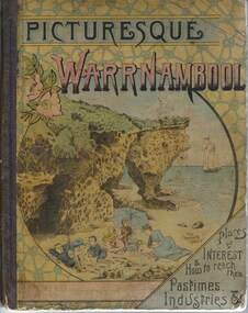
Book, Picturesque Warrnambool, 1891
This book presents a pictorial and written record of Warrnambool in 1891.It covers a wide range of topics. It provides statistical evidence relating to public buildings and organisations of that era, as well as basic information about district points of interest. The Mechanics Institute, the Common, Albert Park, the rivers, the Museum and the Sea Baths are all mentioned. The various drawings and advertisements provide a list of businesses which were prevalent at the time. As this book is one of only two complete copies documented to be still in existence, it is of considerable significance and importance to our collection. The drawings and text are artistically very much of the era and are aesthetically pleasing. Cardboard cover with picture of people on beach in tones of yellow, pink and blue sitting within a circle. Dark purple cloth spine binding. Back cover has drawing of Western Hotel. Pages are not numbered and there are a number of coloured and black and white drawings. Title is in dark purple and Warrnambool is in pink and blue tonesOn front cover “The Mermaids Caves” 1896. 1891 written in pen beneath roman numerals on bottom of title page. List of numbers written down title page in black pen.warrnambool, picturesque warrnambool, warrnambool 1891,, warrnambool, warrnambool 1891 -
 Merri-bek City Council
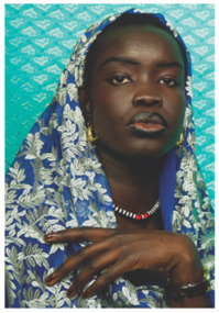
Photograph - Ilford smooth pearl print, Atong Atem, Nyanluak, 2022
-
 Federation University Historical Collection
Book, Final recommendations Ballarat Study Area Land Conservation Council, Victoria, 1982, 1982
Yellow soft covered report of 95 pages . The contents of the report include: Parks, reference areas, wildlife reserves, water production, harwood production, softwood production, flora Reserves and Flora and Fauna reserves, bushland reserves, historic area and reserves, rivers and streams, Roadside conservation and Highway parks, Education areas and School Plantations, Lake Reserves, geological reserves, recreation, scenic reserves, agriculture, mineral and stone production, utilities and survey, township land, Uncommitted Land, military training, other reserves and public land. Maps include: The Study area 1: 250 000 Supplementary Mapsland conservation authority, ballarat, endowment plantations, pine plantations, langi ghiran state park, mount buangor state park, enfield state park, ballarat-creswick regional park, rossbridge, black lake, flax mill swamp, dereel lagoon, lake bolac, lake wongan, langi ghiran reservoir, gong gong reservoir, pincotts reservoir, beales reservoir, wilsons reservoir, moorabool reservoir, korweinguboora, korweinguborra reservoir, learmonth bores, sago hill, illabarook reservoir, ballarat water commission, dunneworthy, mount cole, mont lonarch, ben major, waterloo, trawalla, linton, ross creek, canadian, shepherds flat, lal lal, mount doran, raglan, chute, carngham, buninyong, watsons hill, enfield, cape clear, illabrook, rokewood junction, mount warrenheip, nerrina, jubilee, golden stream, australasian deep lead mine, happy valley school, piggoreet, berringa, bulldog, ballarat common, wildlife, water, timber, flora, rivers, geology, agriculture, warrenheip, biodiversity -
 Eltham District Historical Society Inc
Photograph - Digital Photograph, Alan King, Site of the Diamond Creek Gold Mine, 28 December 2007
The largest gold mine in the area originated from a find in 1862. The mine was closed January 20, 1915 when a fire destroyed nearly all the above ground plant. Published: Nillumbik Now and Then / Marguerite Marshall 2008; photographs Alan King with Marguerite Marshall.; p75 Beneath Mine Hill, as locals call it, runs a network of tunnels once of central importance to the fledgling township of Diamond Creek. These are relics of gold mines, which transformed early Diamond Creek.1 The tiny settlement of about 20 families soared to more than 200 because of gold. For around 50 years, from 1862, gold mining was Diamond Creek’s major source of employment. On September 7, 1854 The Argus newspaper reported a find of a four pound (1.8kg) gold nugget in Nillumbik (an early name for Diamond Creek). Exactly where, is not known.2 The largest mine in the district, the Diamond Creek Gold Mine, apparently originated from a find in 1862. It is said Joe and Dave Wilson were visiting former tailor then cook, Charles Orme, at the southern end of Fraser Street. Sitting on a stump outside the front gate on land belonging to Dr A. E. Phipps the Wilsons found a vein of gold-bearing quartz, which led to the discovery of four quartz reefs varying in width to eight inches (20cm), running north and south. A reef found at the foot of the hill opposite Challenger Street became the Union Mine. This reef was traced south to Allendale Road where a small mine began operations.3 Other smaller mines later operated as well. Dr Phipps immediately began to mine and also built the Diamond Reef Hotel as a boarding house for miners. But Charles Orme, who owned the land alongside, leased his mine to Dr Phipps probably because of insufficient funds and business skills. By mid 1865 the mine had produced 2530 ounces of gold – a 100% profit on the original outlay. Of course there were problems. When the local dam dried up a Blake pump was installed to draw water from the creek. The Union Mine operated under the Diamond Creek Gold Mine management except when disputes sometimes resulted in separate management. However disagreements had to be resolved as the Union Mine depended on Diamond Creek Gold Mine pumps to remove underground water from common reefs. In 1912 the main shaft of about 380 yards (350m) employed 200 men recovering an average of 5000 ounces (141.7kg) of gold a year. But not everyone did well out of gold. Records of failed mining companies in the Victorian Public Record Office, reveal that owner Dr Phipps leased his Right to others. Companies came and went over the next 40 years, most sponsored by Melbourne businessmen who sold shares to gullible locals and then became insolvent. Although there were some good profits, financial returns were haphazard until 1905. Some local residents, who were share holders in short- term companies, became well-known names in modern Diamond Creek such as Scott, Haley, Butler, Alder, Ryan, Wadeson, Reeves, Alston, Paul and Edwards. Gold mining was brought to a disastrous end on January 20, 1915 at 3 pm, when fire destroyed nearly all the above-ground plant. Fortunately no lives were lost. But reopening the mine was almost impossible because of the increasing depth of water in the main shaft. The closed mine destroyed the livelihood of 200 families and the debris took many years to clear.4 In 1946 the Diamond Creek Gold Mine was reopened by the Golden Hind Mining Company, but money ran out before the 600 feet (182.8m) or so of water could be removed. Gold remains in the mine but enormous capital would be needed to buy the land, equipment and to remove the water. Today 12 known sealed shafts along the ridge of the hills on private property extend west for around one kilometre from the corner of Fraser and Haley Streets, crossing Norma and Fyffe to Dering Streets. As recently as 1987, heavy rains revealed a former Union Mine shaft in the Georgiadis family Fyffe Street back yard.5 Allendale Mine, south of Allendale Road, is still open and one of the Union Mine’s main drives (horizontal excavation) remains unsealed, on the Creek Reserve.This collection of almost 130 photos about places and people within the Shire of Nillumbik, an urban and rural municipality in Melbourne's north, contributes to an understanding of the history of the Shire. Published in 2008 immediately prior to the Black Saturday bushfires of February 7, 2009, it documents sites that were impacted, and in some cases destroyed by the fires. It includes photographs taken especially for the publication, creating a unique time capsule representing the Shire in the early 21st century. It remains the most recent comprehenesive publication devoted to the Shire's history connecting local residents to the past. nillumbik now and then (marshall-king) collection, diamond creek, diamond creek mine, fraser street, gold mining, james cook drive, mine hill -
 Eltham District Historical Society Inc
Photograph - Digital Photograph, Alan King, Edendale Farm Homestead, 29 January 2008
Edendale Farm is Nillumbik Shire Council's environment centre situated in Gastons Road, Eltham between the railway and the Diamond Creek. The homestead on the property was built in 1896 and is of historical significance, being the subject of a Heritage Overlay under the Nillumbik Planning Scheme. The Edendale property was originally part of an extensive land purchase in 1852 from the Crown by pioneer Eltham farmer Henry Stooke. He initially purchased 51 acres and later expanded his holdings by purchasing another three adjacent Crown allotments extending northerly from Josiah Holloway's Little Eltham subdivision. Despite clearing the land, Stooke did not build on this property, choosing to live on his property "Rosehill" at Lower Plenty. In 1896 Thomas Cool, Club Manager of the Victoria Coffee Palace in Melbourne purchased 7 acres of the original Stooke land and built the house now known as Edendale. Cool did not farm the land, instead using it as a gentleman’s residence, retiring to Eltham at weekends. In 1918 he purchased an additional 7 acres but in 1919 he sold the property. Later owners included J.W. Cox, the Gaston family and D. Mummery. In the 1980s the Eltham Shire Council purchased the site for use as a Council depot, but this use did not proceed. Subsequently, it was used as the Council pound. The Edendale Farm Pet Education and Retention Centre was established in the summer of 1988/1989 and was set up to replace the existing dog kennels with a high standard pet retention centre. The design style of the building was established to compliment the features of the existing house. It was equipped with 10 retention pens, a veterinary room and a pet education area where school children and other interested parties learnt about pet care procedures. It was later developed into a community farm and was run by an advisory committee and in 2000 it became an Environment Centre. In early 2006 an advisory committee was established for the development of a master plan for future development at Edendale Farm. The committee included Russell Yeoman, a former long-time shire planner and founding member of the Eltham District Historical Society. At the time of filming the Master Plan and future for Edendale was about continuing to develop Edendale as a centre of environment learning and looking at expanding displays and school program, running a lot more of life-long learning and workshops around sustainable living. Covered under Heritage Overlay, Nillumbik Planning Scheme. Published: Nillumbik Now and Then / Marguerite Marshall 2008; photographs Alan King with Marguerite Marshall.; p101 A sharp turn from busy Wattletree Road by the railway line, brings a surprise. Only 1.4 km from Eltham’s centre, sheep feed, blissfully unaware of the hectic suburban activity so close by. At the entrance to the 5.6ha Edendale Farm is another surprise. A work of art that looks like huge tree trunks transformed into bowler and top-hatted men. The Fences Act 1968 by Tony Trembath with Mark Cain and John Doyle, 1996, is classified by the National Trust of Australia as having Regional Significance. The title refers to a government act on disputes between neighbors over the placement of fences and boundaries. This takes a ‘wry swipe’ at a community divided by trivial squabbles. It also celebrates making do with limited resources.1 Further along on the left, the office wall is decorated with a massive Eltham Copper Butterfly, designed by Robert Tickner and made by school children with used plastic bottles and other waste material. Nillumbik Council runs Edendale as an Environmental Education Centre, to help preserve and enhance the local environment. As early as 1988 the former Eltham Shire Council realised Edendale’s importance in meeting people’s needs, particularly of children, to enjoy farmland. The centre, with the Eltham North Reserve to the north - including remnant bushland and open parkland - makes up the major part of the public open space for this area. The council considers this area will become increasingly important to the local community for recreational use.2 Educational programs aim to encourage community involvement to ensure the long-term rehabilitation and protection of natural bushland areas. Edendale is used by people of all ages - from school children to adults - for environmental programs and workshops, as well as for recreation, to enjoy the domestic animals and to picnic. Edendale is also home to the Environmental Works staff who manage reserves and roadsides and support Nillumbik Friends environmental groups. The Friends propagate plants at the nursery, which grows indigenous plants and sells these to the public.3 The centre demonstrates the sustainable living the farm teaches, with features like solar hot water and drive lighting and for the fireplace, logs of recycled cardboard. Edendale has had a varied history as a dog pound and even as a retreat for Thomas Cool, Club Manager of the Victoria Coffee Palace in Melbourne. His single-storey weatherboard house built in 1896, which still stands, was grander than most homes in Eltham. Although such buildings were common in many other parts of Melbourne, Eltham’s poverty and remoteness did not encourage such construction. The Victorian rectangular-shaped house, with a corrugated iron roof and veranda, has elegant large rooms, leadlight windows, ceiling roses, two bay windows and ornately carved wooden fireplace surrounds. Cool bought seven acres (2.8ha) from pioneer Eltham farmer Henry Stooke’s 200 acre (81ha) farm, which he had bought from the Crown in 1852. In 1918 Cool bought an extra seven acres (2.8ha) but in 1919 sold the estate to farmer John Cox. In 1933 Cox sold Edendale to Mrs Elizabeth Gaston, after whom the road leading to the centre was named. The property was owned by several Gaston family members, who called it Edendale, then by a police constable, Douglas Mummery, until the Shire of Eltham bought it in 1970. Oddly Edendale was known as Mummery’s for almost 20 years, although Mummery owned it only for a short time.4 The shire used Edendale as a dog pound until amalgamation with other municipalities in 1996. The pound then moved to the Yan Yean Road, Plenty site, which had been used by the former Diamond Valley Shire Council. To the west and north the centre is bounded by Diamond Creek and on the east by the Melbourne-Hurstbridge railway line. Part of the Research creek forms the centre’s southern boundary.This collection of almost 130 photos about places and people within the Shire of Nillumbik, an urban and rural municipality in Melbourne's north, contributes to an understanding of the history of the Shire. Published in 2008 immediately prior to the Black Saturday bushfires of February 7, 2009, it documents sites that were impacted, and in some cases destroyed by the fires. It includes photographs taken especially for the publication, creating a unique time capsule representing the Shire in the early 21st century. It remains the most recent comprehenesive publication devoted to the Shire's history connecting local residents to the past. nillumbik now and then (marshall-king) collection, edendale farm -
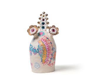
 Merri-bek City Council
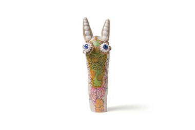
Ceramic - Ceramic, acrylic paint, gold lustre and mix media, Bundit Puangthong et al, FOOD, 2018
These captivating pieces are part of a series called "FOOD / FLESH / FAME," a collaborative effort between Melbourne-based Thai artists Bundit Puangthong and Vipoo Srivilasa. Drawing from Buddhist teachings, the series explores the three elements of attachment: Food (consumption), Flesh (sex), and Fame (power). Although these elements are known to cause suffering, they remain persistently alluring, a paradox that the artists intend to explore further in the future. In creating these pieces, Vipoo Srivilasa initiated the process by sculpting three figures with bare surfaces. Bundit Puangthong then added his artistic touch by painting each sculpture. The artists' conceptual visions harmonized perfectly, especially considering their shared commitment to Buddhist principles, which frequently inspire their respective artistic practices. After Bundit completed his painting, Vipoo enlivened the pieces by adding eyes to the figures. He also embellished the works with pom-poms, lending them a softness that makes them appear both approachable and innocent, despite the weightiness of their themes. Each sculpture embodies a specific teaching from Buddhism: "FOOD" depicts a durian, the king of fruits, painted by Bundit Puangthong. He notes, "Despite its pungent aroma, many people still love to eat it."Donated the by the artists -
 Merri-bek City Council
Ceramic - Ceramic, acrylic paint, gold lustre and mix media, Bundit Puangthong et al, FLESH, 2018
In creating these pieces, Vipoo Srivilasa initiated the process by sculpting three figures with bare surfaces. Bundit Puangthong then added his artistic touch by painting each sculpture. The artists' conceptual visions harmonized perfectly, especially considering their shared commitment to Buddhist principles, which frequently inspire their respective artistic practices. After Bundit completed his painting, Vipoo enlivened the pieces by adding eyes to the figures. He also embellished the works with pom-poms, lending them a softness that makes them appear both approachable and innocent, despite the weightiness of their themes. Each sculpture embodies a specific teaching from Buddhism: "FLESH" features a golden umbrella, serving as a metaphor for sex. -
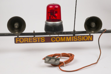 Forests Commission Retired Personnel Association (FCRPA)
Red flashing light and sirens mounted on car rooftop rack
Used on some FCV passenger vehicles during the fire season. Could be activated from inside the vehicle as needed Fire tankers had lights and sirens permanently attachedNot common usage on passenger vehiclesRed flashing light and two sirens mounted on car roof rack. Includes FCV sign, radio aerial and public announcement (PA) system Could be operated from inside vehicleForests Commission Victoriabushfire, forests commission victoria (fcv) -
 Wodonga & District Historical Society Inc
Souvenir - Souvenir Cup and Saucer Woodland Grove, Wodonga, Victoria, Royal Stafford China, c1940s
This item is from a collection donated by descendants of John Francis Turner of Wodonga. Mr. Turner was born on 6 June 1885. He completed all of his schooling at Scotts Boarding School in Albury, New South Wales. On leaving school, he was employed at Dalgety’s, Albury as an auctioneer. In 1924 John was promoted to Manager of the Wodonga Branch of Dalgety’s. On 15/03/1900 he married Beatrice Neal (born 7/12/1887 and died 7/2/1953) from Collingwood, Victoria. They had 4 daughters – Francis (Nancy), Heather, Jessie and Mary. In 1920, the family moved From Albury to Wodonga, purchasing their family home “Locherbie” at 169 High Street, Wodonga. "Locherbie" still stands in Wodonga in 2022. The collection contains items used by the Turner family during their life in Wodonga. A wide range of small china pieces carrying scenic views of holiday destinations or key locations were a popular kind of souvenir during much of the 20th century. Several different items have been produced to commemorate Wodonga and its landmarks over time. These items document key changes in Wodonga and its heritage. This plate depicts three key landmarks in Wodonga. THE SOLDIERS' MEMORIAL in Wodonga was unveiled on Tuesday 18th November 1924. It was designed by Messrs. Hosken & Co., of Hawthorn, Victoria. The monument is all of Australian workmanship. The pedestal is made of Harcourt granite, 9ft x 9ft at the base, and rising in seven courses to a height of 10ft 2in. The emblems (rising sun and wreath) are of bronze, and the lettering of the inscription and names of fallen soldiers are in raised lead letters. Originally the Memorial was completed with a full life size, 6ft in height, sculpture of an Australian soldier in Sicilian marble. The memorial bore the inscriptions: ERECTED BY THE RESIDENTS OF WODONGA AND DISTRICT IN MEMORY of the Men of this Town and District who fell in the Great War, 1914-1919, Also in grateful recognition of the men who served and returned. “Lest We Forget.” In 1982, due to frequent vandalism and high cost of materials to repair, the soldier statue was removed and later installed at the RSL Rooms. THE WATER TOWER is a major landmark of High Street, Wodonga. It began operation from January 1924 until it ceased operation in 1959. It stood unused for a decade until the lower section was modified and put to use as “ The Tower’s Cobbler’s Inn” in 1962. In 1972 Wodonga City Council proposed to demolish the Tower. Their suggestion received an unfavorable response from the city’s citizens, so the Tower still stands today. THE BAND ROTUNDA was officially opened on Sunday 5th September 1920 at the naming of the triangular reserve at the corner of High and Hovell Streets as Woodland Grove. The Wodonga Band gave a public performance on this occasion. The tri-coloured ribbon, which stretched across the entrance to the Rotunda was cut by Mrs R.H Murphy, daughter of Mr. John Woodland, secretary of the Wodonga Shire Council for 35 years, after whom the area was named. The rotunda has since been moved to Martin Park, Wodonga. This item comes from a collection used by a prominent citizen of Wodonga. It is also representative of a domestic item common in the 1940s and features significant landmarks used in many forms to represent the city of Wodonga.This bone china cup and saucer set features an image of Woodland Grove. Wodonga, Victoria. The image incorporates landmarks in Woodland Grove, including the Soldiers' Memorial, the Rotunda and the Water Tower. There is a makers' mark imprinted on the underside of the plate."ROYAL STAFFORD/BONE CHINA/ MADE IN ENGLAND/ 423" . A crown is in the centre of the textmemorabilia, woodland grove, wodonga victoria -
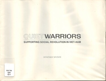 National Vietnam Veterans Museum (NVVM)
Book, United States. Dept. of State. Bureau of Public Affairs, Quiet Warriors: Supporting Social Revolution In Viet-Nam
Here we tell of Americans who are in South vietnam to build. They are there to build, that is . by helping and teaching the people of south Vietnam to build the things - the social links and services and the common institutions - without which no people can have and be a nation.Here we tell of Americans who are in South vietnam to build. They are there to build, that is . by helping and teaching the people of south Vietnam to build the things - the social links and services and the common institutions - without which no people can have and be a nation.vietnam war, 1961-1975 - united states, united states - relations - vietnam, president johnson, vinh binh province, phuong thanh, bien hoa province -
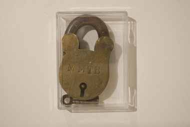 Melbourne Tram Museum
Functional object - MMTB Padlock and Key, Melbourne & Metropolitan Tramways Board (MMTB), c.1920s
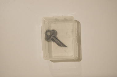
Used for locking correspondence boxes belonging to the MMTB.An object in common use of an organization that has ceased to exist since 1983, with its actual creation date as early as the 1920s.Large metallic MMTB padlock for a correspondence box. The side of the key hole has the inscription "MMTB," while "516" is inscribed on the opposide side. The key is made from similar material to the lock."MMTB" and "516"public transport, mmtb -
 Melbourne Tram Museum
Functional object - Tramways Toilet Key, Melbourne & Metropolitan Tramways Board (MMTB), c.1940s
Used for locking/unlocking toilets presumably maintained by the MMTB and carried by MMTB staff.An object in common use of an organization that has ceased to exist since 1983, with its actual creation date as early as the 1940s.Small metallic key (presumably associated with the MMTB) for locking/unlocking toilets. One side of the key has the inscription "TRAMWAYS.""TRAMWAYS"public transport, mmtb -
City of Kingston
Photograph - Colour, Circa 1993
Edithvale is a suburb in the City of Kingston. It is located between Aspendale and Chelsea on the Port Phillip Bay and built within remnant areas of the Carrum Carrum swamp. The foreshore precinct comprises a wide sandy beach, with low sand dunes and numerous historic boat sheds. The suburb consists of older style dwellings and former holiday houses, combined with mid-century housing and newer homes. The large blocks are increasingly subdivided and the existing dwellings demolished to accommodate units and townhouses, thus changing the landscape of the area and reducing the tree canopy.The beachside suburb of Edithvale was previously part of the extensive Carrum Carrum Swamp. The area was once a source of fish and eels for the Mayone-Bulluk clan of the Bunurong people. Over time the area was drained and predominantly devoted to dairy farming and holiday houses. The farms were gradually sold and subdivided with a large number of homes built after World War II and in the 1960s. Edithvale is mainly residential with a shopping strip along Nepean Highway but little significant industry was ever established in the area apart from a plaster works and confectionary factory, both now closed.Aerial colour photograph of Edithvale as viewed from Alexandra Avenue in the north to Ella Grove Chelsea/Edithvale in the south. The area is built-up with residential housing and facilities including Edithvale Primary School, numerous churches and the Edithvale Railway station. Large sections depict the remnant Carrum Carrum swamp. Edithvale Common and the former "Duck Inn" (Melbourne Water/Friends of Edithvale Seaford Wetlands) can be seen. Edithvale Recreational reserve, the velodrome and Edithvale Public Golf Course are prominent. The image shows vacant land in the area now known as Aspendale Gardens and the newer residential section of Chelsea Heights is not developed. A bike path has been established to cover the secondary drain. The Golf Links Court residential development located off Hughes Avenue is a large vacant block.Yellow circular adhesive sticker on plastic Black ink (marker): * (asterisk) Black type on white adhesive sticker: P000108edithvale, aspendale, chelsea, carrum carrum swamp -
 City of Greater Bendigo - Civic Collection
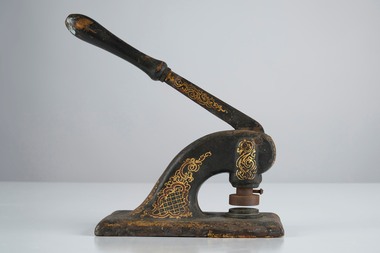
Ceremonial object - Common Seal
The office of the Public Trustee was constituted and incorporated by the Public Trustee Act 1939 which was amended by the Public Trustee Act 1940. The Public Trustee was the successor in law of the Curator of the Estates of Deceased Persons The Public Trustee was empowered to act as administrator, trustee, executor and attorney. On 1 July 1994, State Trustees succeeded the Office of the Public Trustee as Victoria's first State owned company under the State Trustees (State Owned Company) Act 1994. (https://prov.vic.gov.au/archive/VF50). Decorated hand operated cast iron embosser with 35mm stamp head still attached. Gold and maroon painted decorations extend from top edge of handle including scrolls and cross hatching. Well used showing all over signs of wear. Stamp head is for the Public Trustees Kangaroo Flat.Public / Trustees / Kangaroo / Flat -
 Ballarat Heritage Services
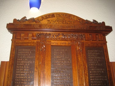
Photograph - Photograph - Colour, Clare Gervasoni, Lakes Entrance and District Honour Board, 27/08/2017
This honor board was made by Robert Prenzel (1866–1941) who was born and trained in Prussia, and migrated to Australia arriving in Melbourne on 24th November on the steamer Habsburg. In Melbourne Prenzel first worked for the German sculptor and modeller Otto Waschatz, decorating private homes and public buildings. From 1891-1901 Prenzel worked in partnership with another German, Johann Christian Treede, after which he continued in business on his own. He also participated in the activities of Melbourne’s Deutscher Turnverein. During the first quarter of the current century he became the major exponent in the field of furniture and woodwork of the cult of nationalism, and was renowned for his carvings, many of them in the art nouveau style, of Australian animals, birds, trees and flowers. The two most common types of Australian timber in his work are mountain ash and blackwood.Colour photographs of a beautifully carved World War One Honour Board by Robert Prenzel.lakes entrance, robert prenzel, world war one, lakes entrance honour board -
 The Beechworth Burke Museum
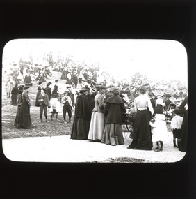
Photograph - Lantern Slide, c1900
This glass slide captures the crowd at the unveiling of the two cannons at Queen Victoria Park which were secured by Sir Isaac Isaacs and presented to Beechworth in 1901. In the forefront of the slide, elegantly dress ladies, some pushing strollers or holding onto children, and dapper gentlemen can be seen gathering around and on top of the park’s iconic rock. The unveiling of these two cannons would have been a celebratory affair for those in attendance, marking a momentous occasion for Beechworth residents which was captured in this lantern slide. The two cannons were secured by Sir Isaac Isaacs who was an influential figure in Beechworth. Sir Isaac Isaacs was born and raised in Beechworth, beginning his education at the Common school and eventually graduated as dux of the Beechworth Grammar School. His commitment to public service was evident early on and he was elected to the Legislative Assembly in 1892, representing Bogong, a district which included Yackandandah and Beechworth. During his time in office, Sir Isaac Isaacs pushed for better education, healthcare, employment opportunities and housing for the people of Beechworth. This glass slide is socially and historically significant as it captures a moment of celebration and advancement for the Beechworth residents while also symbolising an important milestone in the towns history. The slide also, perhaps indirectly, memorialises an important figure in Beechworth history, Sir Isaac IsaacsA thin translucent sheet of glass with a curved rectangular image printed on the front and framed in a black backing. It is held together by metal strips to secure the edges of the slide burke museum, beechworth, lantern slide, slide, glass slide, plate, burke museum collection, photograph, monochrome -
 Wooragee Landcare Group
Photograph, 2004
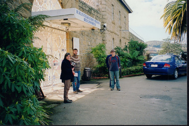
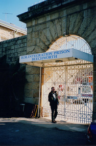
This photo was taken in 2004 and pictures Luke Bailey and Glen Scholfield, the Wooragee Landcare Group coordinator, outside Beechworth Prison. This was the last year Wooragee Landcare Group met with Beechworth Prison Farm and Industry Managers at the prison itself, where they discussed weed and rabbit control on the prison's 'Rockery' block. The weed and rabbit controls that were explored in this event aimed to educate people on how to manage common pests in the Wooragee landscape and improve the appearance of the Beechworth Prison. The Beechworth prison itself is significant as it was built between 1859 and 1864 and is designed using a radiating 'panopticon' method which had proved an efficient, cost-effective design for easy surveillance of prisoners by allowing guards to watch over a large area from a central observation point. The prison is historically significant for its association with the early development of Beechworth as the government administrative centre of north-eastern Victoria. It is part of a major precinct of public buildings and has links to numerous other places in Beechworth which used granite quarried and broken at the prison by male inmates. It is also significant for its associations with the bushranger Ned Kelly and the Kelly storyThe photo holds significance due to the social and educational context the image holds in representing the events Wooragee Landcare Group held in order to educate the public. The photograph also exemplifies the historic significance of the area due to the Beechworth Prison's relation to important historical eras and events.Landscape coloured photograph printed on gloss paperReverse: WAN NA E0NA0N2. NN1- 1 2906 / [PRINTED] (No.15) / 870wooragee, wooragee landcare, wooragee landcare group, beechworth prison, h.m beechworth prison, beechwoth gaol, ned kelly, greg johnson, agriculture victoria, department of primary industries, dpi -
 Wooragee Landcare Group
Photograph, 2004
This photo was taken in 2004 and pictures Greg Johnson, who worked at Agriculture Victoria (formerly known as the Department of Primary Industries, DPI), outside Beechworth Prison. This was the last year Wooragee Landcare Group met with Beechworth Prison Farm and Industry Managers at the prison itself, where they discussed weed and rabbit control on the prison's 'Rockery' block. The weed and rabbit controls that were explored in this event aimed to educate people on how to manage common pests in the Wooragee landscape and improve the appearance of the Beechworth Prison. The Beechworth prison itself is significant as it was built between 1859 and 1864 and is designed using a radiating 'panopticon' method which had proved an efficient, cost-effective design for easy surveillance of prisoners by allowing guards to watch over a large area from a central observation point. The prison is historically significant for its association with the early development of Beechworth as the government administrative centre of north-eastern Victoria. It is part of a major precinct of public buildings and has links to numerous other places in Beechworth which used granite quarried and broken at the prison by male inmates. It is also significant for its associations with the bushranger Ned Kelly and the Kelly storyThe photo holds significance due to the social and educational context the image holds in representing the events Wooragee Landcare Group held in order to educate the public. The photograph also exemplifies the historic significance of the area due to the Beechworth Prison's relation to important historical eras and events.Portrait coloured photograph printed on gloss paperReverse: WAN NA E0NA0N2. NNN- 3 2906 / [PRINTED] (No.13) / 868wooragee, wooragee landcare, wooragee landcare group, beechworth prison, h.m beechworth prison, beechwoth gaol, ned kelly, greg johnson, agriculture victoria, department of primary industries, dpi -
 Vision Australia
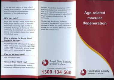
Pamphlet - Text, RBS Eye condition series, 1990?
Two brochures produced to help educate the general public about general eye conditions. As well as common questions, there are images of the eye and the differences in what a full vision person can see and what a person with the condition can see.2 A4 tri-folded brochures about various eye conditionsAge-related macular degeneration Information on Cataractroyal blind society of nsw, pamphlets, education