Showing 459 items matching "quartz mines"
-
 Bendigo Historical Society Inc.
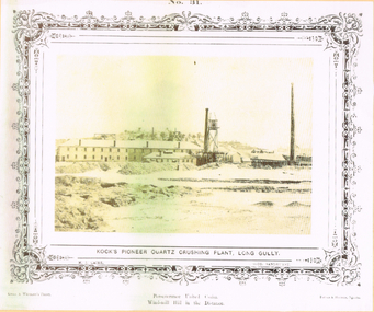
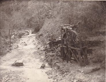
Photograph - LONG GULLY HISTORY GROUP COLLECTION: KOCK'S PIONEER QUARTZ CRUSHING PLANT LONG GULLY
... quartz mines. Henry Koch (1800-1889) was a German sailor who... quartz mines. Henry Koch (1800-1889) was a German sailor who ...The initial partnership in a quartz crushing plant between Henry Koch, Simon Albert and Charles Wallin was dissolved in 1860 with Koch becoming the sole owner. In 1866 the crushing plant consisted of a 50 hp engine and 48 stamping heads capable of crushing 600 tons of quartz per week. By 1902 there were 72 stamps and this was by far the largest crushing plant in the area, serving many quartz mines. Henry Koch (1800-1889) was a German sailor who signed off when his ship reached Melbourne in 1851. Having heard of the gold discovery he proceeded to Bendigo where he was initially employed in puddling in the Myers Flat area. He was soon employed and then made partner in a quartz crushing plant that he became sole owner of in 1860. He was also landlord at the British and American Hotel and the Silver Mines Hotel. HE also started the Perseverance United gold claim. He married Anna Maria Theresia Heinz in 1857. In 1872 he sold the crushing plant for 75,000 pounds and took his family back to Germany. He resumed his trade as a ship builder although he maintained many Bendigo mining interests.Yellow tone photo which has some green through it photo of Kock's Pioneer Quartz Crushing Plant, Long Gully. No 31 printed at the top. The photo has a decorative frame around it. It is a N. J. Caire Photo, Sandhurst and a Casey & Wenborn's Print. Forbes & Holmes, Agents. The photo has a long two storey building with chimneys and some smaller buildings and tall mine chimneys. Printed below is Perseverance United Claim and Windmill Hill in the distance. Paper is mounted on yellow card which is mounted on dark tan card and laminated.bendigo, history, long gully history group, the long gully history group - koch's pioneer quartz crushing plant - long gully, n j caire, casey & wenburn, forbes & holmes, perseverence united claim, windmill hill -
 Bendigo Historical Society Inc.
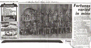
Newspaper - LONG GULLY HISTORY GROUP COLLECTION: KOCK'S MINE WORKERS
... quartz mines. Henry Koch (1800-1889) was a German sailor who... quartz mines. Henry Koch (1800-1889) was a German sailor who ...The initial partnership in a quartz crushing plant between Henry Koch, Simon Albert and Charles Wallin was dissolved in 1860 with Koch becoming the sole owner. In 1866 the crushing plant consisted of a 50 hp engine and 48 stamping heads capable of crushing 600 tons of quartz per week. By 1902 there were 72 stamps and this was by far the largest crushing plant in the area, serving many quartz mines. Henry Koch (1800-1889) was a German sailor who signed off when his ship reached Melbourne in 1851. Having heard of the gold discovery he proceeded to Bendigo where he was initially employed in puddling in the Myers Flat area. He was soon employed and then made partner in a quartz crushing plant that he became sole owner of in 1860. He was also landlord at the British and American Hotel and the Silver Mines Hotel. HE also started the Perseverance United gold claim. He married Anna Maria Theresia Heinz in 1857. In 1872 he sold the crushing plant for 75,000 pounds and took his family back to Germany. He resumed his trade as a ship builder although he maintained many Bendigo mining interests.Photocopy of an article from the Bendigo Advertiser, dated 5/5/1982 titled Fortunes carried in mine. Written above the photo is: Men from Kock's Mine Long Gully. One man is wearing a suit and the rest are in work clothes. The mine was worked, with some breaks, between 1857 and 1871 when the Pioneer Company took over, and was later known as Koch's Pioneer and Perseverance and worked continuously until 1924, a period of 53 years of uninterrupted mining.bendigo, history, long gully history group, the long gully history group - kock's mine workers, bendigo advertiser 5/5/1982, kochs pioneer mine, henry koch, havilah company's claim, garden gully line of reef, paddy's gully line, koch's pioneer and perseverance -
 Bendigo Historical Society Inc.
Negative - ALBERT RICHARDSON COLLECTION: KOCH'S PIONEER CRUSHING BATTERY (EARLY PERIOD)
... quartz mines. Henry Koch (1800-1889) was a German sailor who... quartz mines. Henry Koch (1800-1889) was a German sailor who ...The initial partnership in a quartz crushing plant between Henry Koch, Simon Albert and Charles Wallin was dissolved in 1860 with Koch becoming the sole owner. In 1866 the crushing plant consisted of a 50 hp engine and 48 stamping heads capable of crushing 600 tons of quartz per week. By 1902 there were 72 stamps and this was by far the largest crushing plant in the area, serving many quartz mines. Henry Koch (1800-1889) was a German sailor who signed off when his ship reached Melbourne in 1851. Having heard of the gold discovery he proceeded to Bendigo where he was initially employed in puddling in the Myers Flat area. He was soon employed and then made partner in a quartz crushing plant that he became sole owner of in 1860. He was also landlord at the British and American Hotel and the Silver Mines Hotel. HE also started the Perseverance United gold claim. He married Anna Maria Theresia Heinz in 1857. In 1872 he sold the crushing plant for 75,000 pounds and took his family back to Germany. He resumed his trade as a ship builder although he maintained many Bendigo mining interests.Envelope containing a negative of Koch's Pioneer Crushing Battery. Image shows large building, chimney on left. Negative not scanned.bendigo, mining, koch's pioneer crushing battery -
 Bendigo Historical Society Inc.
Photograph - Norman Penrose collection: Views of Bendigo No.31
... quartz mines. Henry Koch (1800-1889) was a German sailor who... quartz mines. Henry Koch (1800-1889) was a German sailor who ...The initial partnership in a quartz crushing plant between Henry Koch, Simon Albert and Charles Wallin was dissolved in 1860 with Koch becoming the sole owner. In 1866 the crushing plant consisted of a 50 hp engine and 48 stamping heads capable of crushing 600 tons of quartz per week. By 1902 there were 72 stamps and this was by far the largest crushing plant in the area, serving many quartz mines. Henry Koch (1800-1889) was a German sailor who signed off when his ship reached Melbourne in 1851. Having heard of the gold discovery he proceeded to Bendigo where he was initially employed in puddling in the Myers Flat area. He was soon employed and then made partner in a quartz crushing plant that he became sole owner of in 1860. He was also landlord at the British and American Hotel and the Silver Mines Hotel. HE also started the Perseverance United gold claim. He married Anna Maria Theresia Heinz in 1857. In 1872 he sold the crushing plant for 75,000 pounds and took his family back to Germany. He resumed his trade as a ship builder although he maintained many Bendigo mining interests.Sepia coloured photograph of Koch's Pioneer quartz crushing plant, Long Gully. The phot shows Perseverance United claim, Wind-mill and hill in the distance. N.J. Caire phot Sandhurst.Casey & Wenborn's print. Forbes & Holmes agentsviews of bendigo, n.j. caire, sandhurstr, quartz crushing plant, kock -
 Bendigo Historical Society Inc.
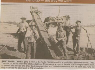
Newspaper - JENNY FOLEY COLLECTION: SAND SHOVELLERS
... quartz mines. Henry Koch (1800-1889) was a German sailor who... quartz mines. Henry Koch (1800-1889) was a German sailor who ...The initial partnership in a quartz crushing plant between Henry Koch, Simon Albert and Charles Wallin was dissolved in 1860 with Koch becoming the sole owner. In 1866 the crushing plant consisted of a 50 hp engine and 48 stamping heads capable of crushing 600 tons of quartz per week. By 1902 there were 72 stamps and this was by far the largest crushing plant in the area, serving many quartz mines. Henry Koch (1800-1889) was a German sailor who signed off when his ship reached Melbourne in 1851. Having heard of the gold discovery he proceeded to Bendigo where he was initially employed in puddling in the Myers Flat area. He was soon employed and then made partner in a quartz crushing plant that he became sole owner of in 1860. He was also landlord at the British and American Hotel and the Silver Mines Hotel. HE also started the Perseverance United gold claim. He married Anna Maria Theresia Heinz in 1857. In 1872 he sold the crushing plant for 75,000 pounds and took his family back to Germany. He resumed his trade as a ship builder although he maintained many Bendigo mining interests.Bendigo Advertiser ''The way we were'' from 2002. Sand shovelers: a gang at work at the Kocks Pioneer cyanide works in Bendigo in December, 1939. The man on the far left is the late Les Warren. Three gangs worked at the site. Each comprised five men, a 'tip-boy' and a horse and dray. Each gang emptied and refilled an 80-tonne iron vat each day. One full dray-load was the equivalent of 112 shovelfuls. The clip is in a folder.newspaper, bendigo advertiser, the way we were -
 Bendigo Historical Society Inc.
Document - DRAINAGE PROBLEMS - NEW CHUM MINES THE DRAINAGE QUESTION
... Victoria Quartz Mine... wire rope at the victoria Quartz mine, the trouble... Department Victoria Quartz Mine Mr Stanfield Mines Act Albert ...Handwritten extract from the Bendigo Advertiser Jan 2nd 1911. ''In absence of Mr McBride, Minister for Mines in the country, officers of the Mines Department were inclined to-day to say much about unwatering the deep Bendigo mines, which is again a pressing problem. Owing to the breaking of the steel wire rope at the victoria Quartz mine, the trouble was intensified. An arrangement had been made by which the companies affected along the line should contribute, but two of the companies, it is stated, suspended operations. A scheme has been placed by Mr Stanfield before the parties interested, and the officers of the Mines Department expressed the hope that for the sake of the future of deep mining, some arrangement should be come to. Unless the companies show a disposition to help themselves substantially, the officers do not think it likely that the Government will co-operate. There are, it was added certain provisions of the Mines Act, and covenants in leases can be enforced, but there is no desire to compel the companies which have carried on in the face of great difficulties, to do anything reasonable.'' Albert Richardson Mining History Collectiongold, drainage problems, drainage problems, new chum mines the drainage question, bendigo advertiser 2/1/1911, mr mcbride, mines department, victoria quartz mine, mr stanfield, mines act, albert richardson. -
 Bendigo Historical Society Inc.
Newspaper - LONG GULLY HISTORY GROUP COLLECTION: FLOODING OF THE VICTORIA QUARTZ
... Vic Quartz G Mine..... Written on the photo is: 4156 ft below Vic Quartz G Mine ...Copy of an article from the Bendigo Weekly 19/5/2000 Discover Bendigo - Flooding of the Victoria Quartz by James Lerk. Article mentions the flooding of the mine, the equipment left in there and where the water had come from. An accompanying photo, taken by Vincent Kelly, shows miners at work underground. John Ennor, the mine manager at the time and William Abraham, the Mining Inspector are in the photo. Written on the photo is: 4156 ft below Vic Quartz G Mine.bendigo, history, long gully history group, the long gully history group - flooding of the victoria quartz, bendigo weekly 19/5/2000, james lerk, william abraham, matthew stevens, 180 mine, new chum and victoria, new chum railway, new shenandoah, new chum reef, south bellevue, nell gwynne reef, new chum drainage association, bendigo advertiser, vincent kelly, john ennor -
 Bendigo Historical Society Inc.
Document - Great Extended Hustlers ,Hustlers Reef, Bendigo, April, 2014
... as 'the first spot in Bendigo at which quartz had been systemically... in Bendigo at which quartz had been systemically mined for gold ...Seven men were killed at the Great Extended Hustler's mine disaster on 2nd May 1914 by an explosion of dynamite occurring as the men were waiting at the plat to ascend the mine at the end of their shift. No blame was attached to anyone in the findings of the inquisition. It was unknown what caused the dynamite to explode. This document formed part of the research done at the time by Bendigo Historical Society, of the 100 years commemoration of the mine disaster, held at Hustler's Hill in 2014. Two page photocopy of article on the Great Extended Hustler's Reef Q.M. Co. Company formed in 1865 and area known as 'the first spot in Bendigo at which quartz had been systemically mined for gold'.great extended hustlers, goldmining, accident, 1873, david bannear, quartz, mining -
 Bendigo Historical Society Inc.
Document - THE RICH VICTORIA HILL AND ITS HISTORICAL ASSOCIATIONS, c1969
... Shaft (George Lansell), Victoria Quartz Mine, Mr E. J. Dunn... Shaft (George Lansell), Victoria Quartz Mine, Mr E. J. Dunn ...Document. 2 copies plus 4 loose sheets. 14 page typed document on the buildings and mines of Victoria Hill in the Gold Era. (10 pages document and 4 pages pictures). Document mentions 'Quartz Miners Arms' Hotel, Conrad Heinz - Bendigo Mayor 1894 and owned a butcher shop in Victoria Hill, British and American Hotel, Manchester Arms Hotel, Victoria Reef Gold Mining Company, Ironbark Mining Company, Hercules and Energetic Mining Company, William Rae, Gold Mines Hotel, David Chaplin Sterry, North Old Chum Mine, Ballerstedt's First Open-cut (J. C. T. Christopher Ballerstedt and Theodore Ballerstedt), Lansell's Big 180 Shaft (George Lansell), Victoria Quartz Mine, Mr E. J. Dunn (Chief Government Geologist). Pictures are- Victoria Hill from Rae's Open Cut, Looking North from Old Chum Hill to the Victoria Hill, Victoria Quartz on Victoria Hill, W. M. Rae's Crushing Works.cottage, miners, the rich victoria hill and its historical associations -
 Bendigo Historical Society Inc.
Document - DRAINAGE PROBLEMS - NEW CHUM MINES DRAINAGE PROBLEMS 1910
... 14 feet at the Victoria Quartz Mine. The water stood... & 27/8/1910 Page 9 New Chum Mines Victoria Quartz New Chum ...Handwritten extract from the Bendigo Advertiser 20/8/1910 Page 8. ''New Chum Mines. Unwatering of the deep levels is being carried on as expeditionsly as was expected by the authorities. In the last four days, the water has only been lowered 14 feet at the Victoria Quartz Mine. The water stood at the 3,226 feet level yesterday. The slow progress being made this week is no doubt due to the large quantity in the workings at some of the levels.'' From the Bendigo Advertiser 27/8/1910 Page 9. ''New Chum Mines. Very slow progress being made. At Victoria Quartz, the water was lowered 32 feet for the week, and is now at 3258 feet. New Chum Railway lowered the water 17 feet and the present level of the water is at 1796 feet. The Lazarus are raising water from 2157 feet. The water has ceased flowing into the New Chum and Victoria through the connecting level with the Lazarus Mine at about 2,500 feet. As the Victoria Quartz is down 4,614 feet, there is still a considerable quantity of water to get out before sinking of the shaft can be resumed.''document, gold, drainage problems, drainage problems, new chum mines drainage problems 1910, bendigo advertiser 20/8/1910 page 8 & 27/8/1910 page 9, new chum mines, victoria quartz, new chum railway, lazarus, new chum and victoria -
 Bendigo Historical Society Inc.
Newspaper - AUSTIN COLLECTION: Koch's Pioneer Gold Mine, Long Gully
... in the area, serving many quartz mines. Henry Koch (1800-1889... in the area, serving many quartz mines. Henry Koch (1800-1889 ...Koch's Pioneer Quartz Mining and Crushing Company was officially registered on June 30th., 1871 (Government Gazette No. 45, 1871). It operated at Long Gully, the first Manager was Andrew Lewis. Nominal capital was 90,000 pounds in thirty thousand shares of 3 pounds each. The initial partnership in a quartz crushing plant between Henry Koch, Simon Albert and Charles Wallin was dissolved in 1860 with Koch becoming the sole owner. In 1866 the crushing plant consisted of a 50 hp engine and 48 stamping heads capable of crushing 600 tons of quartz per week. By 1902 there were 72 stamps and this was by far the largest crushing plant in the area, serving many quartz mines. Henry Koch (1800-1889) was a German sailor who signed off when his ship reached Melbourne in 1851. Having heard of the gold discovery he proceeded to Bendigo where he was initially employed in puddling in the Myers Flat area. He was soon employed and then made partner in a quartz crushing plant that he became sole owner of in 1860. He was also landlord at the British and American Hotel and the Silver Mines Hotel. HE also started the Perseverance United gold claim. He married Anna Maria Theresia Heinz in 1857. In 1872 he sold the crushing plant for 75,000 pounds and took his family back to Germany. He resumed his trade as a ship builder although he maintained many Bendigo mining interests.Two sepia coloured images on paper, possibly taken from book. Top image: Koch's 'Pioneer' Quartz Crushing Works - Long Gully, printed under image. Image shows mining dam in foreground, large two storey mine building in middle background, two mine chimney on right hand side. Bottom image; interior of crushing battery. Printed on bottom ' Quartz Crushing Batteries & etc. Koch's Pioneer'. gold mining, koch's pioneer crushing battery, long gully, perseverance g.m. co., henry koch -
 Bendigo Historical Society Inc.
Document - MCCOLL, RANKIN AND STANISTREET COLLECTION: DIVIDENDS AND SHAREBROKERS, 10th July, 1977
... . Quartz Block Mine. Notes re mines are andwritten on back... Gwynne, Monument Hill Consolidated. Quartz Block Mine. Notes re ...6 page handwritten document. Front page ' List of Directors and Sharebrokers' List of mines. Pages 2 and 3 - list of sharebrokers in Victoria. Page 4 - list of dividends (25th) to Monument Hill Consolidated. Page 5 - dividend Information for North Deborah, Central Nell Gwynne, Monument Hill Consolidated. Quartz Block Mine. Notes re mines are andwritten on back of Bendigo Historical Society typed documents - 'Musicale, July 10th. 1977 at Dudley House. (scrap paper?) Possibly written by Albert Richardson.mccoll rankin & stanistreet, shareholders report -
 Bendigo Historical Society Inc.
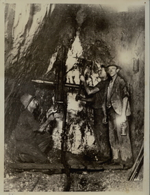
Photograph - DEBORAH MINE: UNDERGROUND
... in Deborah Mine with drill and pick. Lamp on wall. Quartz shows well... in Deborah Mine with drill and pick. Lamp on wall. Quartz shows well ...Black and white photograph. Three males underground in Deborah Mine with drill and pick. Lamp on wall. Quartz shows well. Deborah Mine 1000 ft. level. Inscription on back: A. Richardson, 29 Harrison St., Bendigo.mining, underground equipment, miners, bendigo, mines and mining, mine, mines, miners, person, males, workers, group, central deborah mine -
 Greensborough Historical Society
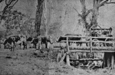
Photograph - Digital Image, Ruston bullock team Panton Hill 1860, 1860_
... to Greensborough and St Andrews. He later carted quartz from the mine... Janefield to Greensborough and St Andrews. He later carted quartz ...Peter Ruston was born in 1824 in Yorkshire. He migrated to Australia in 1850 where he found work as a bullock driver. By 1858 he had saved enough to buy his own bullock team and carted flour from the mill on the Plenty near Janefield to Greensborough and St Andrews. He later carted quartz from the mine at Queenstown (St Andrews) to the crushing plant at Panton Hill.A pioneer Greensborough family.Digital copy of black and white photograph.peter rustin, peter ruston -
Clunes Museum
Map, DEPARTMENT OF MINES, Untitled, c1859
... -emptive area. Indexes for quartz and alluvial mine locations .3.... Indexes for quartz and alluvial mine locations .3 Topographical ...All maps show names and locations of mines operating in the district (see reference section link to article).1 Map of Creswick Clunes - lists 45 mines in the Clunes enlargement and 100 mines in the Creswick enlargement .2 Department of Mines map of Clunes Creswick and shows the McDonald & Co. Pre-emptive area. Indexes for quartz and alluvial mine locations .3 Topographical map Ref GF23 Clunes Mt. Greenock Talbot.1 360 Scale 1:2500 .2 303/59 33 hand written in ink "received 15 October 1859" signed by R Broughton, James Stevenson - District Mining Surveyor .3 40 chains to an Inchgold mining, dept of mines -
 The Beechworth Burke Museum
Postcard, 1920
... and water wheel. Quartz was mined there, with gold also discovered... and water wheel. Quartz was mined there, with gold also discovered ...This postcard depicts the set-up of an abandoned gold mine. This includes a water wheel and other mining implements next to a creek. The postcard inscription indicates that this image is of the remains of the Wallaby Reef battery and water wheel. Wallaby Reef was discovered in 1864, and a prospecting claim established a four head battery and water wheel. Quartz was mined there, with gold also discovered at this location at a later date. By 1878 the mine was no longer resulting in rich deposits, this resulted in the miners moving their search for gold closer to the river where they were able to access more gold. This was in approximately 1879. In 1882 a rich deposit was found. In 1908 the battery was closed, and the mine finished. This photo was taken in 1920 and shows the deterioration of the site since its closure. Gold mining was crucial to the development of the Beechworth area. It has strong research and historical value because the clarity of the photo shows all the minute details of the mining equipment. The text on the back also indicates the mine is the Wallaby Mine, which was used for 45 years to find gold and quartz. Therefore, due to the location being quickly abandoned, this site is a rich location for historical study on gold mining during the 1900s. It can provide important information on the types of tools utilised and the impact of the mining on the environment.Black and white postcard photograph on card.8169 Be / Also near Wallaby Reef Workings / Relics of Rechabite Reef (locality) workings. / Shaft in bed of creek. Wheel used to drive sheadd (?) / stamp battery too I believe near B'worth 1920?beechworth, mining, gold mining, quartz mining, wallaby reef mine, mine battery head -
 Bendigo Historical Society Inc.
Document - RAE'S CRUSHING BATTERY - THE RICH VICTORIA HILL & ITS HISTORICAL ASSOCIATIONS
... Victoria Quartz Mine..., Lansell's Cleopatra Needle type chimney, Victoria Quartz Mine... Rae's Crushing Works Victoria Quartz Mine from Old Chum Hill ...The first five pages are photocopies of photos:- 2 of Rae's Crushing Works; Victoria Quartz on Victoria Hill, Ironbark; Looking North from Old Chum Hill to the Victoria Hill; Victoria Hill - from Rae's Open Cut. Introduction covers location of buildings and mines. Mentioned are:- North Old Chum Mine, Ballerstedt's First Open-cut, Quartz Veins (Spurs), rock formations pitching North, Prospecting shafts 1929, Concrete dam, Engine beds of Lansells Big 180 Mine, Lansells Big 180 Shaft, twenty stampers crushing battery, Lansell's Cleopatra Needle type chimney, Victoria Quartz Mine, Victoria Quartz dams, Rae's Open-cut, Quartz once roasted here to an intense heat, Anticlinal Arch New Chum Line, small primitive tunnels, Prospecting tunnels, Floyd's small 5 head crushing battery, Great Central Victoria (Midway) Shaft, Great Central Victoria engine-bed, Ballerstedt's small 24 yard claim, The Humboldt, Adventure ground, The Advance, Luffsman & Sterry's Claim, A round shaft. Small piece of paper with 'Notes on Victoria Hill complete. Notes prepared by Albert Richardson.document, gold, rae's crushing battery, rae's crushing battery, rae's crushing works, victoria quartz mine, from old chum hill, victoria hill from rae's open cut, ironbark, hercules & energetic, midway, wittscheibe, great central victoria, mr & mrs conroy, central nell gwynne, gold mines hotel, john brown knitwear factory, new chum & victoria, rotary club of bendigo south, north old chum, ballerstedt's first open-cut, lansell's big 180 shaft, cleopatra needle type chimney, a roberts & sons, mr e j dunn, h harkness & sons, eureka extd, new chum railway, pearl, inrush of water at victoria quartz, floyd's small 5 head crushing battery, great central victoria (midway), ballertedt's small 24 yard claim, humboldt, humboldt, great central victoria, victoria hill, bendigo & vicinity 1895 p51, j n macartney 1st edition 1871, bendigo goldfield registry 1871, plan of new chum line, mr rae anderson, annals of bendigo obituary 1904, bendigo advertiser, b m l records mines dept, patterson's goldfields of victoria, dickers mining record 23/11/1861, australian mining standard special edition 1/6/1899 p40, bendigo mines ltd, chinese joss house, fortuna, the victoria goldfield 1851 to 1954, the victoria hill 1854 to 1949 -
 Bendigo Historical Society Inc.
Document - MCCOLL, RANKIN AND STANISTREET COLLECTION: QUARTZ BLOCK MINE TARADALE, 1935/41
... MCCOLL, RANKIN AND STANISTREET COLLECTION: QUARTZ BLOCK.... Curnow & Son re : Quartz Block Mine Auction 1939, folder contains... from J. H. Curnow & Son re : Quartz Block Mine Auction 1939 ...Documents - bundle of documents - agreement for mining lease transfer, agreement for electricity, 1939 'Sale by auction' booklet with items vale(sale price?) Bank Statement, correspondence re: public auction, Power of Attorney 1937 Mary Symmons _ J. & E. Syndicate, agreement lease No. 8294 Castlemaine, list: Addresses of Cheque Receivers' ,suspension of Labour Covenants 1939, transfer of land to L. C. Stuckey, letter from J. H. Curnow & Son re : Quartz Block Mine Auction 1939, folder contains assay reports etc and correspondence re: Auction.MCCOLL RANKIN AND STANISTREETorganization, business, gold mining - legal, mccoll rankin and stanistreet -
 Federation University Historical Collection
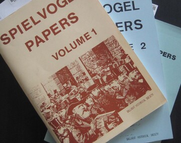
Booklets, Ballarat Historical Society, Spievogel Papers, volumes 1,2, & 3
... Wendouree, Ballarat Quartz Mines, Sebastopol, Ballarat Turf Club..., Lake Wendouree, Ballarat Quartz Mines, Sebastopol, Ballarat ...Nathan Spielvogel was a local historian. The Spielvogel Papers consist of the articles he prepared for a series of weekly talks on Radio 3BA in 1936 and 1937. According to Alex Barnett there is a reference in the Spielvogel Papers to the moving of the bodies of diggers killed at the Eureka Stockade to the old cemetery on 26 November 1857.3 soft covered books with text relating to the history of Ballarat. .1) yellow cover .2) blue cover .3) green cover .1) includes topics such as Gold discovery, Eureka, Main Road, Ballarat Fire Brigade, Ballarat Benevolent Home, Buninyong, Burke and Wills Monument, Chinese in Ballarat, Dana Street School, Ballarat Hospital, Lost Trades of Ballarat, Ballarat Military, Mount Pleasant, Old Colonists' Club, Phoenix Foundry, Ballarat Post Office, Railways, Ballarat School of Mines, South Street Society, Martin Hosking, Charles Curnow Phillips, James Sainsbury, and William Cross Yuille. .2) includes topics such as Ballarat streets, bowls, cricket, football, hotels, Little Bendigo, Lake Wendouree, Ballarat Quartz Mines, Sebastopol, Ballarat Turf Club, Ballarat Zoo, water supply. .3) includes topics such as the Kohinoor Nugget, Eureka, Black Hill, Sebastopol, oddietown, Joe the bellman, Trades Hall, Lal Lal Iron, Ballarat Library, Yuille Creek, Martin Hosking, Stonewall Jackson, steeplechase, Lemonade Paddock, Ivey's Flour Mill, Salvation Army, Stick Jaw Davey, Unicorn Hotel, doctors, Alfred Bells, Ballarat School of Mines Museum (War Museum), Joseph Orange, Ballarat East Post Office.ballarat, speilvogel, nathan spielvogel -
 Bendigo Historical Society Inc.
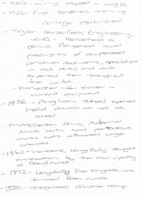
Document - LONG GULLY HISTORY GROUP COLLECTION: 1852 - 1950'S
... Big 180, Ballerstadt's Open-Cut, and the Victoria Quartz Mine...., and the Victoria Quartz Mine. Document LONG GULLY HISTORY GROUP COLLECTION ...Two hand written pages with year dates and what took place at that time. Dates range from 1852 to 1950's. 1950's - mining stopped in Long /G. 1926 - First Teachers training College established. Taylor Horsefields Engineering works - Horsefield a genius. Pioneered local production of compressed air driven roak-drills, specialized in rock bores and drills exported them throughout the world. Harvester - for f/ter in Harvest equipment. 1856 - Anglican School opened held church as well as school. Manchester Arms, Admiral Arms both has pretentious music halls attracted large crowds. 1862 - Ironbark, Long Gully sought annexation by the Municipality of Sandhurst. 1872 - Long Gully Fire Brigade was formed. Keen rivals. 1850 - recognised Chinese camp. ? Long Gully - due to the sinking deeper and the rewards generally richer, became the heart of 'Little Cornwall' - Cornish people. * Tent Church services held in 1862. Long Gully Mine opened April 1852. On the back of the first page is written - Mines - Reefs. mines mentioned are New Chum Hill, the New Chum and Victoria, The Victoria HIll Ironbark, The North Old Chum, Lansell's Big 180, Ballerstadt's Open-Cut, and the Victoria Quartz Mine.bendigo, history, long gully history group, the long gully history group - 1852 to 1950's, first teachers training college, taylor horsefields engineering works, anglican school, manchester arms, admiral arms, municipality of sandhurst, long gully fire brigade, chinese camp, little cornwell, long gully mine -
 Bendigo Historical Society Inc.
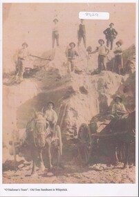
Photograph - Sand mining at the Whipstick
... Old Tom mine included quartz mining and open cut mining... Tom mine included quartz mining and open cut mining. Today ...Old Tom mine included quartz mining and open cut mining. Today the remains of the battery site, cyanide plant, hydrolic sluicing and a 1930's puddler can be seen. It was operating in August 1874 and was taken over in 1897 by an English syndicate, J. R. Syndicate. By 1899 the mine had reached 500 feet in depth . The mine closed c. 1901.8529 Sand mining at Old Tom mine the Whipstick, Eaglehawk. O'Halloran's team of nine men and two horses and carts. Two men with horse and carts; and seven men on top of the sand deposit. A4 copy of 1513 Box 25sand mining, whipstick, old tom mine -
Clunes Museum
Document - POST OFFICE HISTORIC RECORD
... 3486 IN 1901 2426 LONG YIELDING QUARTZ MINES WERE LOCATED... 3486 IN 1901 2426 LONG YIELDING QUARTZ MINES WERE LOCATED ...2 COPIES OF HISTORIC RECORD OF CLUNES POST OFFICE, WHICH WAS OPENED IN OCTOBER 1857, CLUNES WAS A MAJOR GOLD-MINIG SETTLEMENT AND WAS THE SITE OF THE DISCOVERY OF GOLD IN 1851 . IN 1857 IT HAD A POPULATION OF 22O, IN 1861 THERE WERE 1711 IN 1881 5811 IN 1891 3486 IN 1901 2426 LONG YIELDING QUARTZ MINES WERE LOCATED AT CLUNES. THE TOWN IS LOCATED ABOUT 33 KM NORTH OF BALLARAT. IT BECAM AN LPO ON 4 JANUARY 1994 BARRED NUMERAL CANCEL 147 WAS USED AT CLUNES. IT IS RATED AS COMMON POST OFFICERS AT CLUNES HAVE BEEN: MARK PATTINSON 1857-1861 JAMES LYNDONCOLLIER 1861-1884 JOHN HARTLEY KIBBLE 1884-1886 SAMUAL BAKER 1886-1887 AUGUSTUS WOLFE 1887-1890 MATTHEW GLENTON 1891-1903 JAMES DIRLING HUDSON 1903-1912 WALTER CHARLES THORNTON 1912-1918 FRANK EDGAR JOHN BLAKE 1918-1923 HERBERT STANLEY OPPERMAN 1923-1925 WILLIAM HENRY MADDOCK 1925-1928 GEORGE LEONARD POWELL 1928-1929 GEORGE A;EXANDER CAMERON 1929-1934 G A STEVENS (STEPHENS?) 1934-1945 WALTER BERTRAND WILLIAMSON 1945-1950 FEDERA; HENRY GORDEN RODDA 1950-1952 PATRICK JOSEPH LYNCH 1952-1956 THOMAS SELWYN BALLINGER 1956-1962 JOHN PATRICK GRIGG 1962-1966 LESLIE BENJAMIN CARMICHAEL 1966-1975 G M STOUT 1975 TO THERE IS A PHOTOGRAPH OF THE POSTOFFICE AND SOM STAMPS. ONE COPY IS LAMINATED clunes post office, post officers 1857 to 1975, history of post office -
 Bendigo Historical Society Inc.
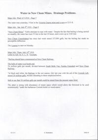
Document - DRAINAGE PROBLEMS - WATER IN NEW CHUM MINES
... in the Victoria Quartz mine and now at 3215 ft. Bgo. Adv 6/7/1910 page 7... Association Water in New Chum Mines Victoria Quartz New Chum ...Handwritten copy of Bendigo Advertiser reports of water in New Chum Mines. (1) 'The water rose yesterday, 9 feet in the Victoria Quartz mine and now at 3215 ft. Bgo. Adv 6/7/1910 page 7. (2) 'New Chum Mines. Futile attempts to cope with water. Despite the fact that bailing is being carried on steadily, the water has risen 55 feet in the last 24 hours, and is now up to 3160 feet. New Chum Consolidated has since last week raised 327,000 galls, but the bailing has made no perceptible difference. The Lazarus to start on Monday.' Bgo Adv 9/7/1910 Page 9. (3) Letter to Adv by A. L.N. Excerpts. 'Bailing should have commenced at New Chum Railway.' 'The bulk of water is at South end. 3.5 million galls per month, divided between South Belle Vue, Eureka Extended and New Chum Railway.' 'In black and white, the Railway in the wet season, July last year with the aid of the Cornish Lift, raised 2.25 million galls, besides attending to those employed below.' 'Safe to say that 3.5 million galls per month could be raised from the present water level.' 'The plant is strong with abundance of steam space which would allow the firewood to be used economically under the barborous Cornish Boiler or wood-eaters'. Bgo Adv 14/7/1910. Document from Albert Richardson Collection of mining history.document, gold, drainage problems, new chum drainage association, water in new chum mines, victoria quartz, new chum consolidated, lazarus, new chum railway, south belle vue, eureka extended, cornish lift, bendigo advertiser 6/7/1910 page 7, bendigo advertiser 9/7/1910 page 9, bendigo advertiser 14/7/1910 -
 Bendigo Historical Society Inc.
Document - VICTORIA HILL - KEY TO SIGN POSTS ON AREA MAP
... Victoria Quartz Mine... Chimney for Lansell's 'big 180' Mine, No 5 Victoria Quartz Mine... Chimney Victoria Quartz Mine Rae's Open Cut Prospecting Tunnels ...Three page hand written carbon copy of Sign numbers at Victoria Hill. No 1 North Old Chum Shaft, No 2 Ballerstedt's First Open - Cut. Special Sign Post, No 2 C Rock Formations Pitching North, No 2 B Rich shallow shafts, No 2 A Quartz veins, No 4 A Concrete Dams, No 3 Engine Beds - Lansell's 'Big 180' Mine, No 3 B Lansell's 'Big 180' Shaft, No 4 Twenty Stampers Crushing Battery, No 3 C Foundations - 'Cleopatra Needle' type Chimney for Lansell's 'big 180' Mine, No 5 Victoria Quartz Mine, No 5 A Fou;ndations Victoria Quartz Poppet Legs, No 5 C Foundations Victoria Quartz Winding Plant, No 5 B Victoria Quartz Dams, No 6 Rae's Open - Cut, No 9 Quartz Once Roasted Here, No 12 Anticlinal Arch, No 15 primitive Tunnels, No 14 Beautifully Coloured Rock Formations, No 16 Adit, Graded Bedding, Oblique Fault, Spurry Quartz Veins, No 17 Prospecting Tunnels, No 18 Floyd's Small Crushing Battery, No 19 Gt Central Victoria (Midway) Shaft, No 20 Great Central Victoria (Midway) Engine Bed, No 21 ballerstedt's Small 24 Yard Claim, No 22 Humboldt Shaft, No 23 Wittscheibe's 'Jeweller's Shop', No 24 The 'Adventure' ground, Large Open - Cut, No 26 Luffsman and Sterry's Ground, NO 27 A Round Shaft, Notes prepared by Albert Richardson.mine, gold, victoria hill, victoria hill, victoria hill key to sign posts on area map, north old chum shaft, ballerstedt's first open cut, lansell's big 180 shaft, 'cleopatra needle' type chimney, victoria quartz mine, rae's open cut, prospecting tunnels, floyd's small crushing battery, gt central victoria (midway) shaft, ballerstedt's small 245 yard claim, humboldt shaft, wittscheibe's 'jeweller's shop', adventure, luffsman and sterry's ground, david sterry, sterry's 'gold mines' hotel, round shaft -
 Eltham District Historical Society Inc
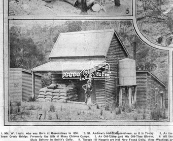
Photograph, Queenstown - St. Andrews District. "Quartz awaiting crushing at the State Battery in Smith's Gully.", c.1929
... bearing quartz extracted from the mines and was a sizeable... bearing quartz extracted from the mines and was a sizeable ..."The State Battery was the central component in the gold mining of this area from the 1920s. The battery crushed the gold bearing quartz extracted from the mines and was a sizeable weatherboard building enclosing the engine and stampers. All that now remains are the bases for the machinery that comprised the battery, one timber and a couple of concrete bases and the nearby dam, which supplied water. However the historic significance of the site remains and is enhanced by the Queenstown Cemetery on the other side of Smiths Gully Road". - Bick Study 1922 This site is now the Peter Franke Reserve and is managed by Parks Victoria Photo Source: The Leader, Nov. 2nd, 1929This photo forms part of a collection of photographs gathered by the Shire of Eltham for their centenary project book,"Pioneers and Painters: 100 years of the Shire of Eltham" by Alan Marshall (1971). The collection of over 500 images is held in partnership between Eltham District Historical Society and Yarra Plenty Regional Library (Eltham Library) and is now formally known as the 'The Shire of Eltham Pioneers Photograph Collection.' It is significant in being the first community sourced collection representing the places and people of the Shire's first one hundred years.Digital imagesepp, shire of eltham pioneers photograph collection, queenstown, st andrews, gold mining, smiths gully -
 Bendigo Historical Society Inc.
Photograph - Victoria Hill, Bendigo, 1973
... . Victoria Hill Quartz Gold Mines are registered as a site.... Victoria Hill Quartz Gold Mines are registered as a site ...Gold was discovered on Victoria Hill in 1854 and by 1861, 1,200,000 ounces of gold had been extracted from the site. The first claim was bought for 80 pounds by Prussian immigrant Christopher Ballerstedt and his son Theodore. Christopher Ballerstedt was nicknamed the "Father of the Hill" and was the first to prove that gold reefs extended below the surface. His 200-foot plus mine shafts yielded quartz rich with gold, inspired other miners, and were instrumental in Bendigo becoming the world's deepest and richest goldfield. The site still features relics of nineteenth century mining including quartz crushing machinery and the foundations of George Lansell’s 180 mine. These features are characteristic of Bendigo’s mining history and represent two prominent nineteenth century miners, Christopher Ballerstedt and George Lansell, who held important roles in the development of Bendigo. Victoria Hill Quartz Gold Mines are registered as a site of significance. The site is of historical, archaeological and scientific importance to Victoria. The mines represent the symbolic heart of Bendigo’s gold mining history and the importance that mining played in wealth creation and the development of Victoria. The diggings reserve is accessed from the rear of Albert Richardson Reserve located at 40-56 Marong Road, Ironbark. The site has steep and unformed paths and is closed to the public at dusk. It is important to stay to the paths to avoid the diggings. Interpretive signs help visitors to appreciate the importance of the site and the remaining relics of Bendigo’s mining history.Victoria Hill Ironbark, Bendigo. Photos of the poppet head, sand heap, tailings, shafts and tunnels. Before development into a tourist attraction.history, bendigo, victoria hill, ironbark, diggings -
 Bendigo Historical Society Inc.
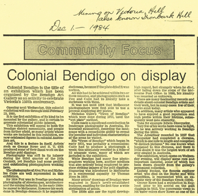
Newspaper - LONG GULLY HISTORY GROUP COLLECTION: COMMUNITY FOCUS - COLONIAL BENDIGO ON DISPLAY
... . showing the excavation of quartz reef and mine buildings near Iron... 1875. showing the excavation of quartz reef and mine buildings ...Copy of a newspaper article titled Colonial Bendigo on display. Date written at the top of the page Dec 1 - 1984. Article mentions an exhibition organised by the Bendigo Art Gallery of the early photographers on the gold field. Wet plate photography was used. Other mediums were also used such as engraving, artists drawings, lithography, water colours and diorama. Artists mentioned are George Rowe, S T Gill, Alex Fox, Nicholas Caire, Wet Plate Photography, Thomas Ham, Edwin Stocqueler and Ludwig Becker. There is also a photo by Nicholas Caire, taken 1875. showing the excavation of quartz reef and mine buildings near Iron bark Hill.bendigo, history, long gully history group, the long gully history group - community focus - colonial bendigo on display, bendigo art gallery, george rowe, s t gill, alex fox, nicholas caire, wet plate photography, thomas ham, edwin stocqueler, the advertiser, ludwig becker, burke and wills expedition, mine buildings near ironbark hill, victoria hill -
 Bendigo Historical Society Inc.
Document - LONG GULLY HISTORY GROUP COLLECTION: COLONIAL BENDIGO ON DISPLAY
... , taken in 1875, showing the excavation of quartz reef and mine..., taken in 1875, showing the excavation of quartz reef and mine ...Copy of an Advertiser Article titled Colonial Bendigo on display. The article mentions an exhibition organised by the Bendigo Art Gallery to celebrate Victoria's 150th anniversary. Mentioned are the artists George Rowe and S T Gill. The photographers Alex Fox and Nicholas Caire. Thomas Ham introduced engraving in a commercial capacity. Edwin Stocqueler and Ludwig Becker are also mentioned. Written above the article is: Mining on Victoria Hill, also known as Ironbark Hill. Dec 1 - 1984. On the back glass plates are mentioned. Also S T Gills water colours, lithographs and engravings. There is a photograph by Nicholas Caire, taken in 1875, showing the excavation of quartz reef and mine buildings, popper legs and chimneys near Ironbark Hill.bendigo, history, long gully history group, the long gully history group - colonial bendigo on display, bendigo art gallery, george rowe, s t gill, alex fox, nicholas caire, thomas ham, edwin stocquelerthe advertiser, ludwig becker, burke and wills, victoria hill, ironbark hill -
 Bendigo Historical Society Inc.
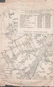
Document - MINING REPORTS - MAP OF PART OF THE BENDIGO GOLDFIELD INCLUDING WHITE HILLS AND EAGLEHAWK
... Mine Victoria Quartz 4614 ft. Names of Mines are Garden Gully..., Calls and Dividends. Also Deepest Mine Victoria Quartz 4614 ft ...BHS CollectionMap of part of the Bendigo Goldfield including White Hills and Eaglehawk. Map shows reef lines, gullies, railway line, tram route, type of rock, name of mine, Calls and Dividends. Also Deepest Mine Victoria Quartz 4614 ft. Names of Mines are Garden Gully United, Great Ext'd Hustlers, Johnson's Reef, South New Moon, New Moon, Catherine Reef, Virginia, Central Red White & Blue, Ironbark, Kock's Pioneer, Carlisle and the Hercules & Energetic. Map is part of the Albert Richardson Collection of mining documents and research. document, gold, mining reports, mining reports, map of part of the bendigo goldfield including white hills and eaglehawk, pabst bendigo goldfield, garden gully united, great ext'd hustlers, johnson's reef, south new moon, new moon, catherine reef, virginia, central red white & blue, ironbark, kock's pioneer, carlisle, hercules & energetic. victoria quartz -
 Bendigo Historical Society Inc.
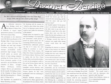
Newspaper - LONG GULLY HISTORY GROUP COLLECTION: THE MINE FLOODING CRISIS - BENDIGO'S DEPUTATION TO THE MINES MINISTER MCBRIDE
... Victoria Quartz Mine... of the Victoria Quartz. Of the 11 mines, 5 were willing to contribute... Victoria Quartz Mine S H McGowan Bendigo Mine Owners Association J ...Copy of an article from the Bendigo Weekly 25/6/2000 titled The Mine Flooding Crisis - Bendigo's Deputation to Mines Minister McBride by James Lerk. The participants in the deputation were S H McGowan, J H Craig, G A Petrie, J G Stanfield, George Lansell Junior, H E Rowe, A Capper Moore, I E Dyason, S L Stirling, Senator McColl, J Sternberg, T Hicks and T Glass. It was hoped the Government would provide a pound for pound subsidy for the unwatering of the Victoria Quartz. Of the 11 mines, 5 were willing to contribute. The Minister thought dams would be ineffective. There is an accompanying photo of Minister Peter McBride.bendigo, history, long gully history group, the long gully history group - the mine flooding crisis - bendigo's deputation to mines minister mcbride, bendigo weekly 25/6/2000, james lerk, hon p mcbride, victoria quartz mine, s h mcgowan, bendigo mine owners association, j h craig, g a petrie, j g stanfield, george lansell junior, h e rowe, chamber of mines, a capper moore, i e dyason, d l stirling, senator mccoll, j sternberg, t hicks, t glass, new chum, lazarus, 180 mine, new chum consolidated, new chum railway mine, mr merrin, peter mcbride